
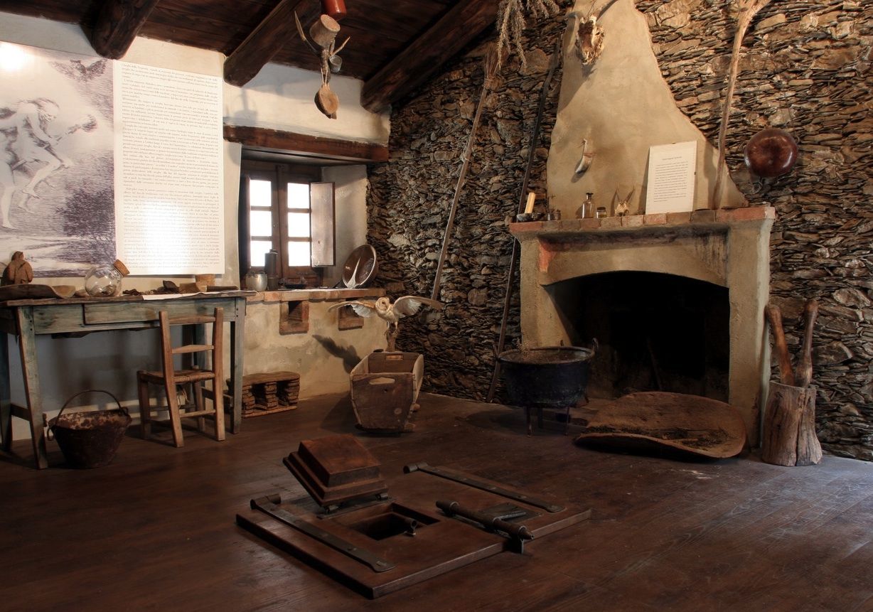
Sa Bovida Spanish Jail
A stone arched passageway and a narrow stairway connect the upper and lower parts of Aritzo, a mountain village nestled in the woods of the Barbagia di Belvì. Once through the vaulted passageway (sa bovida, in Sardinian) you’ll find yourself in front of an imposing 17th century building built of blocks of shale, sand and mud, infamous for being a maximum-security prison. Over the centuries, this Spanish prison took the name of its celebrated pointed arch, and dozens of prisoners at a time were locked up within its walls, in dire conditions, until the 1940s. Among the inmates locked up in its dank cells were also some French officers captured during an attempted landing by Napoleon in 1793.
The interior was recently renovated and you will be able to visit four of the rooms. The first one was the surveillance room, the others were cells for male and female inmates, while one of the rooms had no door at all, until one was recently put in. Today, the prison is a museum where you can see an exhibit entitled Bruxas, dedicated to witchcraft in Sardinia between the 15th and 17th centuries. You will see religious, magical and esoteric ritual objects like cloth dolls, potions, herbs and medicines, as well as cauldrons and mortars. One section of the exhibit is dedicated to the Inquisition and features a collection of instruments of torture. You'll also see a sanbenito, a penitential dress that suspected witches were forced to wear. Finally, you’ll see an ancient sundial in the internal courtyard.
Aritzo is also the town of chestnuts, surrounded by forests and streams, including is Alinos and the funtana of sant’Antoni. To enjoy its enchanting landscapes, you can take a walk to Texile, a 24 mt high, mushroom shaped, natural monument of limestone. In town you can visit sa Bovida, casa Devilla, a 17th century Spanish building, the Arangino castle, a medieval-style building constructed in 1917, and the ethnographic museum, where you can immerse yourself in local pastoral culture admiring artisanal masks, tradition garments and tools used in daily life.
Bonnanaro
The "cherry town" has a long and ancient history, linked to a "piece" of Sardinian history, the Bonnanaro culture of the early Bronze Age (1800-1600 BC). Bonnanaro is a small town with a population of 1000, overlooking the valley between Mount Arana and Mount Pelao, in the Meilogu sub-region of Logudoro. The surrounding hills have numerous water courses and springs, making them particularly fertile; they are planted with cherry trees, for which the town is famous within the island, and vines, with rare grape varieties used to produce an excellent wine. In mid-June, the popular cherry festival is held.
The Villa Gunar, later known as Gunnanor, was built around the year 1000 under the direction of the convent of San Pietro di Sorres. Today, the elaborate layout of the historical centre includes 18th and 19th century ancestral homes as well as the churches of Santa Maria Iscalas, Santa Barbara and Santa Croce (1624), and the Neoclassical parish Church of San Giorgio Magno, with its valuable paintings.
At the foot of the Pelao is the Church of San Basilio (early 19th century) and five kilometres from the town lies the sanctuary of Nostra Signora di Monte Arana, dedicated to the Madonna delle Grazie, with a forecourt overlooking the Valle dei Nuraghi: an unmissable panorama. The church is surrounded by cumbessias, lodgings for pilgrims during the novenas, and a statue of the Vergine delle Grazie which is entrenched with legends. Some traditions are linked to the Spanish dominion, which is reflected in highly detailed embroidery, bright colours, coral jewellery and filigree in traditional costumes, which you can admire during the local festivals. The musical culture has particularly strong roots in the Bonnanaro choirs.
The countryside has been inhabited since the Neolithic, as shown by the necropoli of Pertusos, sas Turres and the domus de Janas at the necropoli of Corona Moltana, dug into the rocky walls of a plateau two kilometres out of the town. Of the five underground tombs, Tomb I is the best known: it has a corridor leading through a small door into a rectangular antechamber with a sloping roof. From here you can pass through to the main chamber. At the bottom of the walls are two dug-out niches, where two individuals lay (whose skeletons were found in 1889) alongside 18 containers and a small bronze ring. Tombs III and V are also well conserved, better than II and IV. Human bones, ceramics and funerary items are all on display at the Museo G.A. Sanna di Sassari, along with the burial method, have led to the definition of a cultural facies known as the ‘Bonnanaro culture’, which developed in the 2nd millennium BC. The Faeddas, Nieddu, Maria de riu, Penternu and Toncanis Nuraghes date back to the later phases of the Bronze Age. The area continued to be occupied in Roman times, leaving ceramic remains found on Mount Arana and at sas Turres, where a mansio was located along the Olbia-Turris Lybisonis (Porto Torres) road.
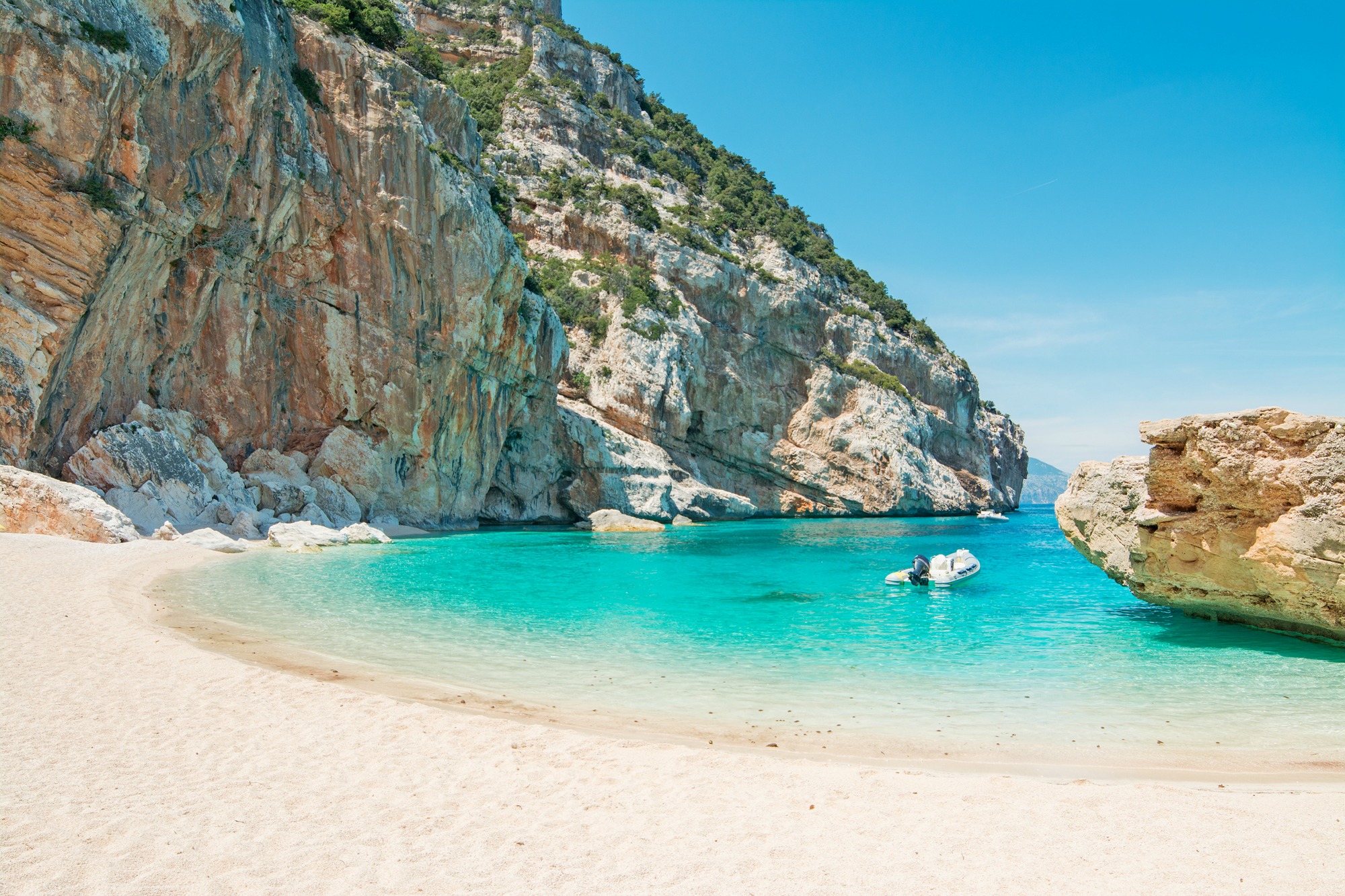
Cala Mariolu
Dive into this sea that looks like it has been painted. It is also known as ispùligi de nie (snow fleas) because it consists of small round, pink and white pebbles, mixed with sand. Cala Mariolu, in the territory of Baunei, gets its name from the Mediterranean monk seal that is said to have ‘stolen’ the fish from the nets of the fishermen from Ponza and was therefore called the mariolo (thief).
Its landscape is striking, with its endless shades of blue, emerald green and sky-blue, as well as its pebbles that resemble snowflakes. The cliff surrounding it reaches a height of 500 metres and looks out onto the sea both to the north and to the south, making Cala Mariolu accessible from the land only via a challenging trekking trail (for experts) through dense Mediterranean scrub. In the past, Punta Is Puligi acted as a place in which coal could be loading by the furisteris, the coal merchants who populated the Baunei area.
The seabed with its shallow waters is worth exploring with a mask, for those who have less familiarity, or with diving equipment for those who want to explore its depths: it is the habitat of various species. You can even catch a glimpse of dolphins offshore from time to time. Out of the water, you will see the peregrine falcon and the Eleonora's falcon, the European shag and the golden eagle.
A large rock, sa perda 'e su saltatori, acts as a pier. In fact, the cove is easier to get to via the sea, in private boats or using services heading to the coves that depart from the ports of Arbatax, Cala Gonone and Santa Maria Navarrese. Nearby, there are numerous caves, one of which is in the cove: it begins with a little beach and is ten metres deep, which is the result of the incessant movement of the sea over the centuries. Not far away, there is the charming Grotta del Fico. During your trip along the gulf, there are other little coves not to be missed: the unspoilt Cala Goloritzè, the splendid Cala Sisine and Cala Biriola and one of the beaches symbolizing the Mediterranean, Cala Luna, halfway between here and the territory of Dorgali.

Nurallao
Sheltered by two limestone hills, it sits next to SS 128, separating Campidano from the island’s interior. Nurallao is a town of 1400 inhabitants in Sarcidano, a border area between the provinces of south Sardinia and of Nuoro, with strong agro-pastoral activity and craftworks: it is famous for producing lime, shingles and pots. Deposits of refractory and china clays near the town were the source of considerable income in the first half of the 20th century. Past mining activity, which is now in decline, is attested by the abandoned mines of Niachili and by various kilns, including Funtan’e Susu, an industrial archaeology site. Until the 1960s, the mines were serviced by mining rail lines. Today they are part of the Trenino Verde line, which connects Isili with Sorgono passing next to Lake San Sebastiano. The lake is fed by Sarcidano river, which flows by common and holm oaks and Mediterranean shrubs of the Funtana is Arinus Park and forms the Su Craddaxioleddu Waterfall. This natural oasis, just north of the town, hosts the Festival of Is Tallarinus Nuraddesusu, typical dish of Nurallao, on Easter Monday, and a Sheep Festival paired with the Procession of Sant’Isidoro of is traccas (floats) in May. The most highly-anticipated event, the Regional Music Festival, takes place in September. At the end of June, the Feast Day of the patron saint, Saint Peter the Apostle, is celebrated with a procession in traditional dress that sets off from the parish church, where a 17th century statue of the patron saint is housed. The Church of Madonna della Strada is a must see. Set in the woods, it is the final stop of a mid-August pilgrimage undertaken for the Driver’s Festival.
Nuradao is mentioned in the peace treaty between Eleanor of Arborea and John I of Aragon (1388). The place name may derive from the Nuragic-Etruscan word for mound or walls. The Punics built fortifications around the town, which was then occupied by the Romans, who left traces at Sa Bidda Becia. Here, one can see the remains of houses, roads and wells of a village and the Baths of Cannedu (I-III AD). In Nieddiu, in the vicinity of which a fascinating Well Temple can be found, stands one of the area’s nine nuraghes. At Sa Conca ‘e Sa Figu, bronze statuettes of Sardus-Pater and a goddess were uncovered, in addition to a considerable amount of tin and lead, as well as a building, possibly a bronze foundry. Most importantly, in Nurallao, there is one of the biggest megalithic tombs in all of the Mediterranean: the Giant’s Tomb of Aiodda. Located in Pranu is Ciaexius, on the border with Nuragus, it is shaped like a taurine protome with an exedra of orthostatic slabs and an arched stele, at the base of which, a small door leads to 10-metre long burial chamber. Pottery fragments, copper and bronze pins, and fragments of steles with sculpted symbolic patterns similar to those found on menhir statues of Sarcidano (i.e. upside down human figures with and without daggers), were found. The burial dates back to 15th century BC, however it was in use even before, as seen from the “recycled” menhirs dating to 3000-2500 BC.

Lodè
In the Middle Ages, the southernmost border of the Gallura Giudicato, which is now the border between the provinces of Nuoro and Sassari, this town spreads out at the food of Mount Calvario, surrounded by the Mount Albo chain and the granite forms of nearby villages. Lodè is a mountain town in Alta Baronia with 1700 inhabitants; it is part of the Borghi Autentici d'Italia circuit, and its fertile land is watered by springs and the riu Mannu, which forms the sos Golleos waterfall. The agricultural and pastoral town has stone houses with wooden balconies, "interrupted" streets, narrow alleyways and arches, laid out around medieval churches: the parish church of Sant'Antonio Abate who is celebrated with bonfires in mi-January, the churches of su Rimediu and the Vergine d'Itria. The rural church of San Giovanni Battista is particularly characteristic, with celebrations held in late June with a palio horse race in honour of the saint. The carnival is very popular, with traditional local masks (sas mascheras nettas and su Maimone) and evocative Holy Week rites. During the celebrations you can taste the local gourmet specialities. Starting with several types of bread: calistros, coccone, simula, cozzulasa (with ricotta or pieces of lard) and cocconeddu chin s’ovu, at Easter. Recipes include sa manicatura with pork or mutton, potatoes, cabbage, chick peas and onion, and su pane vratau with layers of "braised" carasau, sauce, pecorino cheese and egg. Typical local pastries are amarettos with almond paste, aranzata with almonds and orange peel, and orugliettas with honey and puff pastry.
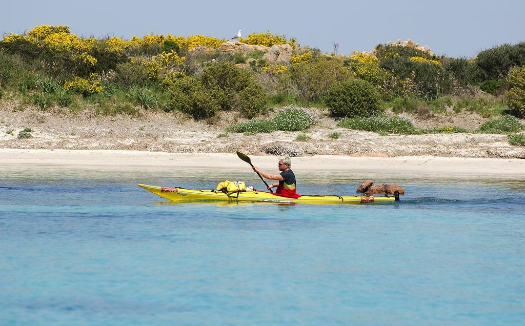
Part of the Tepilora park falls into Lodè territory, one of the most florid areas of the island, with nearly 8000 hectares of uncontaminated forest (recognised by UNESCO in 2017). It includes the plateau and woodland of Sant'Anna - with a suggestive sanctuary dedicated to the saint, part of the Usinavà forest, dotted with rocks modelled in various forms, and Mount Albo, an impressive range of light coloured limestone mountains, with ravines, crevasses, caves and peaks reaching over 1000 metres and the pure white peak of sos Aspros, a nature reserve populated by mouflons and royal eagles. The park extends from the woods of Tepilora as far as the mouth of the Posada rivulet, an element connecting mountain and sea. Herons, black-winged stilts and flamingos nest in the delta, and it is the ideal setting for kayaking. You will find well-marked paths, once used by charcoal burners, with prehistoric sites and pinnettos, ancient shepherds' huts. The paths running up to Punta Cupetti are ideal for trekking. The earliest traces of human settlement at Lodè date back to the Neolithic, with some domus de Janas, known locally as calas 'e sos naneddos (dwarves' caves). The most important Bronze Age finding is the sa Mela nuraghe on Mount Prana, where you will also see the foundations of the ancient villages of sos Lothos and Thilameddu.

Porto Alabe
The name is Catalan and it means seagull. The beach of Porto Alabe is a wide expanse of compact medium-large grain sand, of various colours, from white to golden yellow and ochre, that looks out onto limpid waters that vary in colour from emerald green to blue and, behind it, there is a background of sand dunes covered in Mediterranean greenery: it is the gem of the Tresnuraghes seashore. Moving along the six kilometres of Provincial road 83 that separates the village of Planargia from its marine district of Porto Alabe, you will have the impression that you are quickly passing from evocative hilly, agricultural and pastoral landscapes to the blue of the sea, which is decorated every year with the five sails of the Legambiente Blue Guide. Cliffs surround the edges of the beach, the final part of the rias, or volcanic hills with terraces gently descending to the coast. The waters are shallow and the seabed slopes gently, making bathing easier and is ideal for families with children. There is parking and there are refreshments points close to the beach.
Going beyond the promontories that delimit it, you will find numerous and isolated little beaches of fine pink sand. In order to catch get to them, from the car park, you can follow convenient trails along the rocky crags. As well as the smaller coves, Porto Alabe stretches for several kilometres: it is one of the longest sandy stretches in the Planargia and Montiferru regions, after Bosa Marina (ten kilometres away). The coast of Tresnuraghes takes up a total of seven kilometres. Along with the sand, there are tall sea stacks, on top of which the Aragonese built a coastal defence system consisting of the Foghe tower, near the mouth of the riu Mannu, and those of Ischia Ruja and Columbargia. The natural harbour of Foghe was always a landing place for invading Moors and pirates. In Antiquity it had already been a landing place for the Ciddilitani of Roman origin and the Euticiani from the Greek island of Euboea. Here, the ancient town of Ciddilis may have appeared.
Tresnuraghes owes its name to three nuraghi that were once near the village: only traces of one of them still remain. However, there is abundant evidence of the Bronze Age in the territory: the nuraghi of Martine, Nani and Tepporo and a Tomb of Giants along the road leading to the church of san Marco. Near the rural sanctuary, you will also see proof of the Neolithic period: domus de Janas and the dolmen su Ju Malmuradu (meaning petrified saddle). In the centre, the houses are mostly low and they were built around the parish church of San Giorgio Martire, one of the numerous churches in the village. Both in religious and nonreligious contexts, you can taste Malvasia, the well-known DOC wine. The Casa Deriu museum is a must. Here, you can go on a journey back in time through the history of journalism, the Sardinian press, fashion, travel and bourgeois life in the 18th-18th centuries.

Lu Bagnu
This is one of the few parts of the Castellanese shore, mostly consisting of high cliffs of red trachyte, which are formed by a great strip of sand. The Lu Bagnu beach, a neighbourhood of Castelsardo (two and a half kilometres from it), is protected by rocks lined in green: to get to the beach, climb down the steps from the town. The fine sand is the colour of cream, and its clear bottom is dotted with flat rocks that appear here and there, keeping the water warm and pleasant. The beach is suitable for families, thanks to its shallow waters, and is very popular among teenagers. It is perfect for diving aficionados, thanks to its transparent waters brimming with fish, an invitation to hours of adventurous snorkelling. There are several restaurants around, and camping is permitted.
For those interested in windsurfing and sailing, take a look at the cliffs and the La Capra beach, which defines a western boundary with Lu Bagnu, where the sea and the rocks create a natural pool.
After a day at sea at Lu Bagnu, use your evening to visit the ancient town of Castelsardo, which, perched on a promontory, is part of the select list of Italy’s most beautiful towns, a perfect combination of sea, history and identity tradition. Interesting buildings line narrow, steep streets: the town is surmounted by the Doria castle, who founded the town in 1102. Today the castle is the seat of the interesting Museo Mediterraneo dell’Intreccio (Museum of Mediterranean Weaving). Not far sits the cathedral of Sant’Antonio Abate, with its coloured bell tower overlooking the sea.
In the past, Lu Bagnu was the sea of Tergu, six kilometres away, a town famous – just like Castelsardo – for its Holy Week rituals and its Romanesque church of Nostra Signora di Tergu, made of red trachyte and white limestone.
Oniferi
Surrounded by the impressive Gennargentu mountain chain, the town is nearly 500 metres above sea level and looks over the splendid sa Costa valley, cloaked in cork, oak, holm and wild olive trees. Oniferi is a medieval town in the Barbagia di Ollolai region, and is divided into six neighbourhoods with a total population of 900: su Nodu, Mount Ormina, santu Juvanne, su Cantaru, su Pizu de s’Ortu, Untana e Sant’Antoni. The town centre hosts the new parish church of Sant'Anna, with its original 15th century foundations, subsequently extended to three naves in the 20th century, and the old parish church of San Gavino Martire, dating back to the 15th century and of considerably artistic value, surrounded by a lawn. The old patron saint is celebrated at the end of October, while in mid-January, the bonfires are lit for Sant'Antonio Abate and wine and typical local pastries are consumed. Oniferi is one of the towns where the canto a tenore tradition continues, handed down from generation to generation, and now recognised as a UNESCO cultural heritage. Some groups from Oniferi have become world famous. You can also discover the cultural, craft and gourmet attractions during the Autunno in Barbagia tour.
The hilly land around the town, crossed by the Rivu Mannu, an affluent of the River Tirso, is mostly used for pasture. Above all, the area has been settled since the Neolithic, and has a huge array of archaeological sites: numerous domus de Janas, dolmens, menhirs, Giants' Tombs and around 40 nuraghes fall under local jurisdiction, and date from the period between the mid-Bronze Age and the Iron Age (1700-900 BC), including Ola, Murtas, Badu Pedrosu and Brodu. The last is near one of the three most interesting prenuraghic necropolises, dug out of the rock, with symbols carved into the walls. The second is sos Settiles, surrounded by menhirs. The third is the sas Concas necropolis, a complex of twenty domus de Janas that is the largest and oldest in Barbagia (dating to 2700 BC), where other subterranean burials otherwise appear isolated or in small groups. The fascinating prehistoric monument (one of the most important in Sardinia) is set in a trachyte area on the edge of the SS131 DCN highway towards Nuoro, and is known not only for its size and structure, but also for mysterious architectural elements and symbols: graffiti of stylized, upside down men, perhaps representing the dead, are carved onto the walls of some of the tombs (Hemicycle, X and New West). Hemicycle's Tomb is unforgettable: formed of an anticamera, a large semi-circular room with a sloping roof and five other secondary cells.

Bados
Bados lies in the Bados area, in the commune of Olbia. The beach has light-coloured fine sand verging on grey and a number of rocky outcrops. The long beach, which is situated just before the commune of Olbia’s beach, stretches for around 300 metres and part of the beach is given over to a bathing establishment. Its shallow waters make it safe for children.
Isola Piana - Isola dei Cavalli
Transparent waters with infinite shades of blue, emerald green and turquoise appear before your eyes. If you want to experience a true natural paradise, you can disembark in heavenly places and swim in the sea where you will find the rare beauty of the islands of Piana and Cavalli, located in the marine area of Tavolara - Punta Coda Cavallo. On the small island of Cavalli, which you can get to via sea following the indications to the park, you will find a beach of light, fine, firm sand, surrounded by lush Mediterranean scrub. All around, the sea is crystal clear and its waters are shallow. A little way out, rocks stand out of the water, signalling the route for boats. In the distance, off the shore of Porto San Paolo and to the east of its 'little sister', you will notice larger Isola Piana. Here, there are various little beaches of fine sand, which is a greyish colour with hints of pink and ochre. On the horizon, you will see in the shallow waters, smooth rocks with tinges of pink and yellow, typical of the Gallura coast.
As well as the two little islands, you can use private boats or organized tours to visit the whole protected area stretching from Capo Ceraso to Isola Ruia, to the south of Capo Coda Cavallo: 76 kilometres of coast in the territories of Loiri Porto San Paolo, Olbia and San Teodoro and 15 thousand hectares of sea. You can admire the impressive granite island of Tavolara and the red porphyry rocks of Molara. Touching strips of land covered in Mediterranean Scrub, you will come across the islands of Porri, Topi, Drago and the little island of Rosso. Between one stop and another, during navigation, you can dive into the crystal clear waters and explore the marvellous seabed. You can do some breathtaking diving, like living in a documentary at Punta del Papa, in the shallows of Punta Arresto and in that to the north-east of the rock of Molarotto. You will find yourself in places rich in varieties of fish and marked by the passage of whales and dolphins, and where it is common to find the remains of ships and boats from any age, among which the mysterious shipwreck of Molara that lies at a depth of approximately 40 metres. This is a 19th century motorsailer, 70 metres long and with a tonnage of over 2 thousand tonnes (at the time already a beautiful 'antique'), on its way to Marseilles from Syria. It was sunk by an English submarine stationed in that part of the Tyrrhenian sea, perhaps during the Second World War.