
Su Crucifissu Mannu
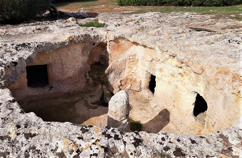
The Nurra is a ‘mine’ of heritage from the past, with a concentration of dozens of archaeological sites spread over a few square kilometres. One of the most fascinating is located just outside the town of Porto Torres and is partially hidden, maybe to continue to protect the secrets it has been keeping for thousands of years. It is the necropolis of su Crucifissu Mannu, a complex of domus de Janas dug out of a bank of limestone rock. 22 tombs have been found so far. Their construction began in the Late Neolithic period (3200-2800 BC) and were used continuously until the Early Bronze Age, around the 16th century BC. Since 2025, the site has been included—together with 16 other necropolises—in the list of Sardinian sites designated as Unesco World Heritage.
The hypogea are all multi-cellular, meaning that they are composed of several rooms, which can be accessed via a vertical well or descending dromos (corridor) entrance. The structure is typical of the domus found in the Sassari area, with an anteroom, a cell and rooms that open up in the walls of the main cell.
Three tombs in particular will leave a lasting impression on you: tomb VIII has two small rooms at the end of the dromos, followed by a large quadrangular cell and ten other rooms around it. A door opens up on one wall, above which there are two inscribed protomes. Tomb XII has 15 rooms, organised in a complex manner: some burial chambers are located at an opening on the right wall of the anteroom and others around the main cell beyond the door, of which you will notice the manhole cover still lying on the threshold. Tomb XXI will surprise you with its decorations: in fact, there are bull’s heads with crescent-shaped horns in the various rooms, as well as false doors and traces of columns supporting the vaults.
Inside the necropolis, numerous burial objects were found, useful for accurately dating human presence in the necropolis, and also skeletal remains, two of which showed signs of drilling on the skull. This was not an operation carried out on the dead, because in at least one case the person survived the mysterious practice. Several hypogea have lost their roofs, due to caving on the surface above, caused by the passage of the road connecting Turris Libisonis and Karales (the Roman ancestors of Porto Torres and Cagliari). Another enigma concerning su Crucifissu Mannu is also linked to the road and is represented by a series of straight furrows cut into the rocky surface. The most likely scenario is that they were caused by Roman carts that transported blocks of limestone to the port, following a change of route due to collapses in the necropolis. According to another theory, however, they could date back to the Nuragic age and are linked to rituals that are still unknown. On the subject of mysteries and religiousness, less than six kilometres from the necropolis, you can admire a temple, unique in Europe, at ziqqurat in Monte d’Accoddi, a majestic and almost contemporary sacred altar at su Crucifissu Mannu.

Gairo Vecchio
It seems that the name gairo means ‘land that flows’. It is not by chance that the events that tormented this place, starting at the end of the 19th century, precisely due to the instability of the land on which it stands, had a dramatic outcome in October 1951. Today, in ‘old’ Gairo, you can see the ruins of the buildings that have remained tenaciously clinging to the rock of the Trunconi mountain, which dominates the valley of the Pardu rivulet below, with little dirt and cobblestone alleys linked by steps and sloping lanes. In fact, the roads delimited the terraces on which the buildings stood and they are therefore positioned horizontally, on staggered levels, along the slope.
Accounts tell the story of five days of incessant rain and wind in Ogliastra that made the original centre of Gairo, already exhausted by half a century of collapsing grounds and landslides, unsafe for people and animals. The streets turned into raging torrents, making the land ‘slide’ dramatically towards the valley. For obvious reasons of safety, the village was gradually abandoned: the last of its inhabitants left their homes during the decade that followed. The families of Gairo were able to choose where to live and divided themselves between: the ‘new’ Gairo, which is the present-day Gairo Sant’Elena, built a few dozen metres upstream, a village a few kilometres away surrounded by greenery, namely the hamlet of Gairo Taquisara, and a village much further downstream that took the name of Cardedu, which was built from scratch on the plain located a short distance from the splendid beaches of Marina of Cardedu itself and that of Gairo.
You will experience a timeless atmosphere while observing buildings made of granite and schist, bound by mud or sand and lime mortar. The lime was produced in a kiln that was active until a few decades ago, located where the hamlet of Taquisara emerged. Some buildings had three or four floors and today, the wrought iron balconies still resist in some of the façades. Entering the village on foot or by bike and peeping into the houses from the road, you will notice fireplaces, staircases, windows and plastered walls painted blue. Your thoughts will carry you back to moments of intimate family life in a distant past. The feeling of abandonment increases as you observe the vegetation making its way through the ruins and reclaiming spaces that once belonged to it. Every now and then, vegetable gardens pop up, some of which are apparently still being cared for.
After visiting the village, you can continue the excursion in the surrounding area: near Gairo Taquisara, a lush holm oak wood contains is Tostoinus, an oasis in which there are typical cuiles – stone and wood buildings used by shepherds -, perennial springs and the remains of a Nuragic village. Following the ‘path of the eagles’ you can reach the top of the ‘butte’ of Perdu Isu, where there is a 360-degree view, and visit the archaeological complex consisting of nuraghe, a village and a sacred well. On top of another butte, that of Osini, stands the impressive nuraghe Serbissi, exactly ten kilometres from another village, namely Osini vecchio, which shares the same fate and the same poignant atmosphere with Gairo vecchio.
Sella del Diavolo
Its unmistakable profile is one of Cagliari's most characteristic features, leaving an impression due to its particular shape and dominant position on the Poetto beach. The Sella del Diavolo (Devil's Saddle) occupies the exact centre of the Golfo degli Angeli (Gulf of Angels) and is the offshoot of the Sant'Elia hill that reaches out to the sea. For decades now, the promontory has been a favourite destination for trips just a stone's throw from the city centre, ideal for hiking, even at night, with surprising traces of human habitation that have alternated over millennia, and an irresistible attraction for the view from its summit. The scenery is so impressive that, according to legend, even heavenly and demonic hosts fought over it. The myth is told in two slightly different versions, particularly in terms of the reason for the 'heavenly battle'.
According to the most popular version, the devils were enthralled by the place and tried to take possession of it. According to the variant, however, it was the angels who asked God for this enchantment, chosen for its purity and absence of evil, as a gift, triggering Lucifer's jealousy. The battle took place in the skies above the coast of Cagliari and saw the victory of the army of angels led by the archangel Michael. During the battle, Lucifer lost his saddle, which fell and turned into rock, giving rise to the promontory. This gave rise to the name Sella del Diavolo (The Devil's Saddle) and also the name Golfo degli Angeli (Gulf of Angels), as the inhabitants of the large inlet wanted to name it after their saviours.
Paths branch off from the square next to the small beach of Calamosca or from the small port of Marina Piccola, allowing you to explore the promontory, offering unmissable views of the landscape, up to, on clear days, Capo Carbonara, including the view of the twelve kilometres of Poetto and its promenade and, behind them, the profile of the Molentargius-Saline Park. Along the way you will notice European fan palms, junipers and wild olive trees, as well as mastic trees and euphorbias. The promontory also offers shelter to rare birds, such as peregrine falcons, kestrels and Sardinian partridges. It is also not uncommon for foxes and wild rabbits to appear in the bushes.
The natural cavities around Capo Sant'Elia have yielded traces of habitation since the Neolithic period. On the highest point are the ruins of a Punic temple dedicated to Astarte, as testified by the discovery of a slab preserved in the Archaeological Museum of Cagliari. You will also see two cisterns, one of Punic origin, larger than the second from Roman times. A perimeter of foundations leads back to the former church of Sant'Elia, most likely built in the 11th century by the Vittorini monks together with their monastery. According to tradition, the saint was martyred on the hill. The watchtower, part of the coastal defence system against Saracen raids, is of Spanish origin. In Catalan it was called pouhet (‘little well’) and the name Poetto is thought to derive from this. Finally, some military structures, including a blockhouse that you will encounter along the way, date back to the Second World War.

Spiaggia delle Vacche
It is named this way because it seems that years ago it was frequented by cows that lazed here peacefully in the sun. Today, it continues to be a small, restful corner of paradise on earth, set between granite rocks with soft lines shaped by the wind and surrounded by Mediterranean scrub. The ‘spiaggia delle vacche’ (beach of the cows) is located in the territory of San Teodoro, in the locality of Monte Petrosu, and is part of the marine protected area of Tavolara – Capo Coda Cavallo. It is a small thirty-metre strip of fine cream-coloured sand, rocky outcrops and a crystal clear sea, reflecting shades varying from blue to emerald green depending on the light. The water is shallow with a sandy seabed and is sheltered from the winds. From the beach, you can admire a captivating panorama, with the islands of Tavolara and Molara in front of theIsolotto Rosso (Red Islet) with the promontories of Porto San Paolo on the left. At sunset, the rocks are coloured with various pink and reddish shades.
To reach the beach, you can take the state road SS 125 in the direction of Olbia up to the small village of Monte Petrosu, then you can follow the Cala Girgolu road (or Ghjlgolu) until you reach an area equipped as a car park. From here, a path branches off, between granite rocks and dense vegetation, leading to a series of picturesque little coves: the first is the famous Cala Ghjlgolu, in the territory of Loiri Porto San Paolo. Here, the ochre-coloured sand is mixed with pebbles; around it, there are numerous ‘tafonate’ rocks, eroded by the wind and water that create cavities, and behind it a pond, the habitat of numerous species of seabirds. On the beach, you can rent pedalos, dinghies and kayaks to get to the nearby beaches, including the ‘spiaggia delle vacche’ and the small cove that precedes it along the path, known as ‘spiaggia della tartaruga’ (turtle beach) due to a distinctive turtle-shaped rock. To the north-east, you can also admire the ‘scogliera dei sassi piatti’ (cliff of flat stones), which owes its name to the polishing action of the waves that, when breaking on the coast, have made the rocks and rocky walls smooth.
San Teodoro is a renowned tourist resort that boasts numerous coastal ‘pearls’ located in the protected area of Capo Coda Cavallo: the most famous are La Cinta, a very long, thin golden strip washed by the blue sea, and Cala Brandinchi that has a Caribbean landscape, with an arch-shaped white sandy shore and a turquoise sea. A promontory overlooking the sea separates it from Lu Impostu, its natural continuation, while, further south, you will find the beautiful s’Isuledda with its rocky spur delimiting the protected area to the south: 500 metres of soft white sand leading into a shimmering sea, with sand dunes covered in Mediterranean greenery.
Mining village of Orbai
Paradoxically, its most captivating feature, that of being located in the middle of a lush forest with a splendid view of the Cixerri river valley, contributed to its decline, until it closed down. Its isolated position, the difficulty in reaching it and the consequent excessive cost of transporting lead, zinc and barium extracted from its quarries, together with the collapse of their price on the international markets, meant that the gates of the Orbai mine already closed in the 1950s. Today, abandoned buildings remain, bearing witness to a historical period that saw the emergence of dozens of small workers’ villages around wells and tunnels throughout the Sulcis – Iglesiente and Guspinese areas, characterised by the hard work of the miners and the continuous coming and going of people and means of transport, after which it entered a melancholy decline towards the last decades of the 20th century.
The village of Orbai is located on the slopes of the mountain of the same name, in the territory of Villamassargia, and was active for about 80 years. The first concession dates back to 1872, in favour of a company known as ‘degli Orbi’, which is where Orbaigets its name. An English company, United Mines Ltd, then an Italian-French company, Pertusola, were entrusted with it, building a small village and a washing plant. In 1943, the concession passed to the ‘Orbai mine’ company, which built a modern flotation system. Following an unsuccessful relaunch attempt in the early post-war years, the mine was closed and the concession was considered to have ceased to exist for good in 1968. Today, you can see the area of accumulation of flotation sludge and, not far away, the remains of the washing plant and furnace. Continuing along the path that branches off between holm oaks and strawberry trees, you will come to the village, with the recently-restored buildings that originally contained the management offices: along one side there are the houses intended for the miners, many of which have never been lived in.
You will come to Orbai by following provincial road SP 2 towards Villamassargia and taking the signposted diversion on the left. Alternatively, you can visit Orbai as the second stage of a tour coming from the mine of Rosas, in the territory of Narcao, along a route that stretches eight kilometres into a dense forest. Rosas is an open-air industrial archaeology museum, where a washing plant with a wooden roof stands out, in which there is a museum exhibition.
In the territory of Villamassargia, there is not only industrial archaeology, but also prehistoric traces dating back to the Bronze Age, as shown by the Santu Pauli and Monte Exi nuraghi and the Giants’ Tombs of Monte Ollastu. The town played an important role in the age of the Judicates, when the castle of Gioiosa Guardia was built, a ‘lookout’ over the Cixerri valley and the park of centuries-old olive trees s’Ortu Mannu, dominated by sa Reina, a natural monument with a trunk that has a 16-metre circumference.
Beata Vergine Assunta - Guasila
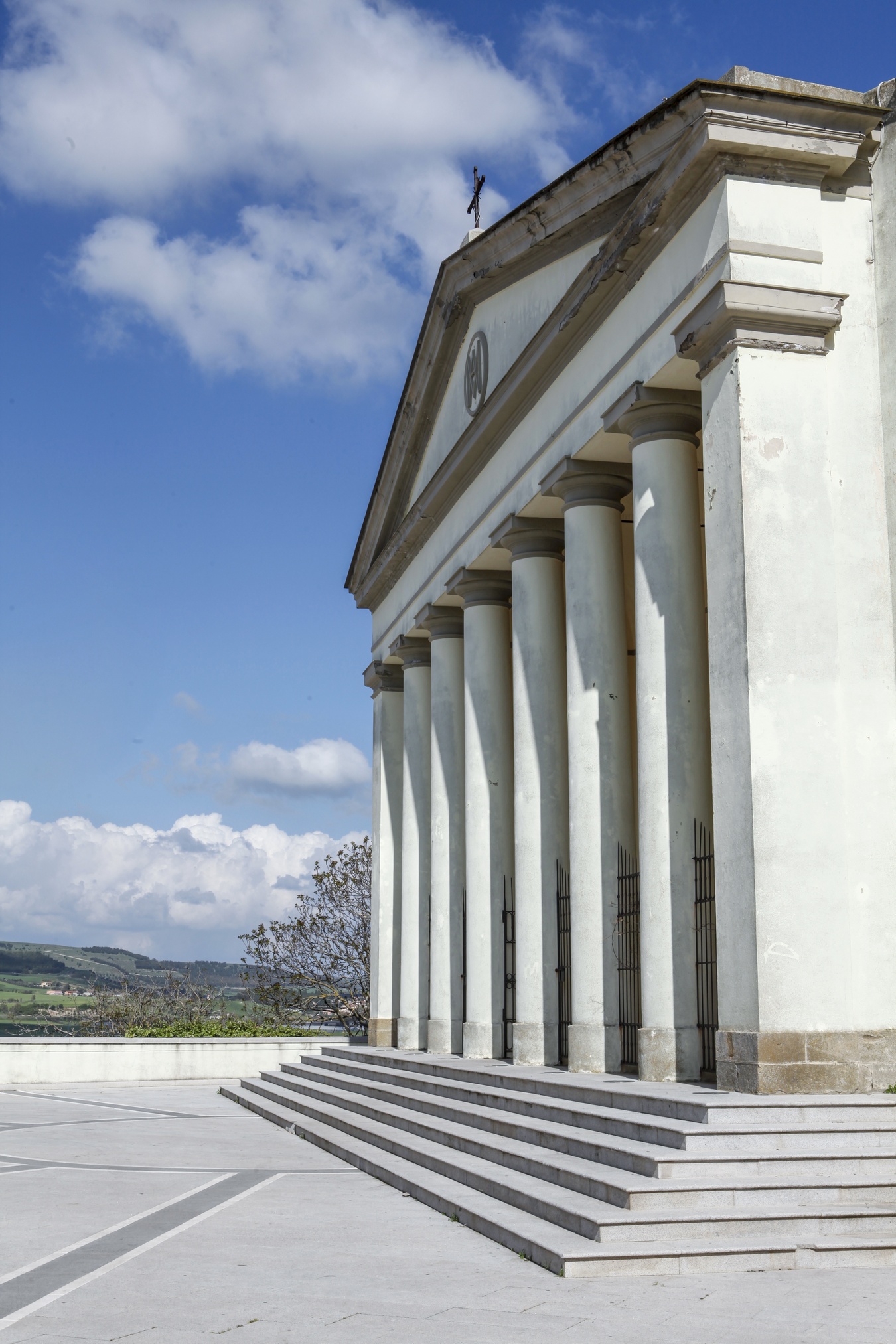
The inspiration for its shapes brings to mind the Pantheon in Rome and Palladio’s architecture. It is the main place of worship in Guasila, the heart of the village, and it is a true temple with an imposing and, at the same time, elegant appearance, built in that neoclassical style so dear to its designer, architect Gaetano Cima. The Parish Church of Beata Vergine Assunta dedicated to the Assumption of the Blessed Virgin Mary was designed in 1839 but building began three years later and was completed in 1852. It has an octagonal layout and you can enter the central body through a pronaos with six Doric columns, preceded by a stunning staircase. The tympanum is supported by two corner pillars.
The building was constructed on the site of a previous place of worship; in fact, the bell tower next to the façade on the right dates back to the 18th century. Inside the church hall, you will be impressed by the domed vault, with decorations that have geometric and floral motifs stretching from the base of the dome to the centre, closed by a skylight. The walls are punctuated by eight columns and six chapels open up between them, two of which are main ones. In the first, dedicated to Santa Maria, there is a statue depicting the dormitio virginis and a simulacrum of Saint Peter the Apostle that, according to tradition, comes from the village of Sennoru, one kilometre from Guasila, that later disappeared. On the days preceding the celebration of the patron saint, the dormitio virginis is the protagonist of a dressing ritual of Byzantine origin: the simulacrum is placed on a golden bed, sprinkled with oils and perfumes and dressed in sumptuous clothes and with is prendas, jewels and a silver crown. The statue is then placed in the centre of the sanctuary. The second main chapel is dedicated to the body of Christ and contains a simulacrum attributed to Antioco Lonis, a sculptor from Senorbì active in the 18th century. The presbytery, separated from the church hall by a marble balustrade, contains the main altar made of multicoloured marble. In its central niche, you can admire the statue of Our Lady of the Assumption between two angels. At the foot of the tabernacle, the remains of Saints Primo, Engrata and Benigno are kept in a walled-in urn, placed under a black stone. Items that come from the old parish church of Guasila include a baptismal font, a holy water font and a pulpit made in the early 19th century.
On the right of the temple, built as a diocesan sanctuary in 2002, you will see the Oratory of the Rosary. Its building dates back to the 18th century, while sources report that there was already an oratory operating in Guasila in the 16th century, with the name of Obraria de Nostra Senora del Rosser. A few steps away from the church, you can admire the precious liturgical items, vestments, reliquaries and the votive offerings from the sanctuary exhibited in the museum of Scrinia Sacra, located in the rooms of the building that was once a prison, then a town hall and today a place of art and culture.

Vignola Mare - Aglientu
This captivating landscape is even more breathtaking at sunset, when the sun goes down behind a Spanish tower, highlighting the hints of pink in the sand and rocks. During the day, it treats the eye to a thousand different colours in the sea and among the pebbles on the beach. This is the vision offered by the beach of Vignola Mare, in the Aglientu area, which received the Blue Flag award for water quality, environmental protection and high-quality services.
Vignola Mare was originally a fishing village and is now a tourist resort that still has uncontaminated stretches, surrounded by granite cliffs and Mediterranean scrub. Its sandy shore is divided into two parts at the point where the Vignola rivulet forms a small lake, which has a low flow rate during the summer, near a granite rock. The largest part, in front of the village, stretches for over a kilometre and features golden sand, with hints of pink due to the granite grains and mixed with pebbles smoothed by the sea. The stretch beyond the lake is also called La Turra or ‘beach of the tower’. In fact, it lies at the foot of a promontory on which a 16th-century Spanish defence tower stands.
The cove is crescent-shaped and the sand has different characteristics, as it is fine, white and soft. The sea in both sections is crystal clear, reflecting shades of blue, turquoise and emerald green, becoming deep blue offshore. The clearness of the water on the seabed makes the coast a destination for snorkelling, diving and underwater fishing enthusiasts, also because it is particularly rich in fish fauna. Meanwhile, its exposure to the winds attracts windsurfing, kitesurfing and sailing lovers. Its location on the slopes of the promontory provides La Turra greater shelter.
The main stretch of the coast is full of services: large car park, well-equipped area for camper vans, refreshment areas, beach equipment and boat rentals, diving centre and access for disabled people. A path surrounded by Mediterranean scrub will lead you to the Tower of Vignola, which was built using granite ashlars to guard an ancient tuna fishery and as a lookout for barbarian incursions. From the tower, you can admire a captivating view of the sea and the hinterland, while the outline of Corsica appears on the horizon. If you look to the left, you’ll notice another little cove, with similar characteristics to La Turra, that can be reached via the same path that leads to the tower. The cove is called beach of San Silverio, due to the solitary presence, at the northern limit of the beach, of a picturesque church dedicated to the saint it is named after, built in front of the sea in the early 20th century by the fishermen of Ponza.
Bingionniga
Nature patiently worked to create this place over millions of years. The artists are wind and water, which have carved the rock, shaping majestic limestone towers, the Buttes of Ogliastra, between which some dense, luxuriant vegetation has developed and is crossed by torrents. This is the captivating landscape that makes the state-owned forest of Bingionniga stand out, as it extends for over 400 hectares, almost entirely in the territory of Jerzu, while a small part of it falls within that of Tertenia, at an altitude that varies between 250 and 750 metres. It is mostly made up of holm oak forests, with a lush undergrowth and species of phillyrea. In the areas where the holm oaks thin out, a dense Mediterranean scrub has developed, with strawberry trees, mastics, rockrose and heather making up the greenery. The rocky areas are particularly enchanting, with various native species like the coronilla and the terebinth. The waterways tend to have a seasonal flow: the main ones are the rivulets of Moliapas, Alusti and Su Crabiolu.
You can explore the forest along numerous paths, on foot or by bike, and you can also reach the top of the ‘buttes’: in one of these, there is the fire lookout of Mamutara, with a spectacular 360-degree view. You will be captivated by the surrounding landscape and the colours of the cliffs ‘immersed’ in the greenery of the woods. From the plateau above Mount Arbu, Taccu in Tertenia, you will see rugged limestone peaks, centuries-old trees and other ‘buttes’, while to the east you will see a large part of the Ogliastra coast, from Marina di Tertenia to Santa Maria Navarrese. It is no coincidence that the Arbu is nicknamed ‘the enchanted mountain’.
The nature trails spread between the Buttes branch out into the heart of Ogliastra, from Monte Ferru to the north, through the Rio Pardu valley, Mount Corongiu, the most spectacular panoramic viewpoint of Jerzu, with traces of a Punic necropolis on the top, and across the territory ofUlassai. Nature has created plenty of unmissable attractions here, starting from the grotto of Su Marmuri, one of the most impressive caves in Europe, as well as one of Sardinia’s most majestic natural monuments. Other places absolutely worth visiting are the waterfalls of Lequarci and Lecorci, an exciting ‘water landscape’ where the waters of Lecorci flow at the foot of abutte, just below Su Marmuri, and, three kilometres further downstream, join the waters of Lequarci, with its cascade measuring almost a hundred metres.

Spiaggia del Relitto
It is arch-shaped, set in an enchanting bay surrounded by thick Mediterranean greenery. The whiteness of its beach is almost blinding and contrasts with the vivid colours of the sea, reflecting shades of emerald green, blue and turquoise. To the side, a few steps from the shore, lies the ‘landlord’, the skeleton of a motorsailer that ran ashore in 1955. The Spiaggia del Relitto (Beach of the Shipwreck) occupies an eastern coastal stretch of the promontory of Punta Rossa, south-east of Caprera, the second largest island in the National Park of the Maddalena Archipelago.
The Blue Flag has been flying here for years, because of the clearness of the water and environmental sustainability. The surrounding landscape is wild and uncontaminated, enclosed by rugged and ‘protective’ rocky cliffs. The water is transparent, with a sandy seabed, and is shallow near the shoreline, then sloping gently away from the shore. The outline of the Isola della Pecora (Sheep Island) in front of the beach is dominant: the stretch of sea between the beach and the islet falls within the integral reserve area of the park and, therefore, navigation, mooring, fishing and scuba diving are forbidden.
The wreck has been occupying the beach since the afternoon of 22 June 1955, when a fire broke out on board the motorsailer Trebbo, which was headed for Cagliari, carrying a load of coal. The impossibility of putting out the fire led to the decision to run the vessel ashore at the safest point, which was west of Isola della Pecora. You can visit the ‘shipwreck’ by car, by driving over the bridge connecting La Maddalena and Caprera, alongside the island in a southerly direction. After passing the village of Stagnali, you will cross the isthmus that leads to the promontory of Punta Rossa. Continuing east along a scenic dirt road set in the scrub, you will come to a car park, about 250 metres from the beach. On both sides of the strip of land that connects the southern extremity of Caprera, there are enchanting coves, including another stretch awarded the Blue Flag: the beach of I Due Mari (The Two Seas), so called due to the two beaches opposite each other, one on each side of the isthmus, featuring fine white sand and a turquoise sea with rocky outcrops. Caprera holds many other jewels: to the north-west, the pink granite surrounds Cala Serena, Cala Garibaldi and Cala Napoletana, with a sea so transparent that it seems unreal. Then, to the north-east, you will be breathless as you admire the ‘Sardinian Tahiti’, Cala Coticcio, a real natural swimming pool set in the granite and surrounded by uncontaminated Mediterranean greenery.
Cala Sarraina
It stretches for about 200 metres in a natural amphitheatre painted red by the trachyte rocks and green by the surrounding Mediterranean scrub and its sand is multicoloured - pink, red and orange -, while its sea is blue, reflecting shades of emerald green. What looks like a picture painted by an inspired impressionist artist is, in reality, the landscape of Cala Sarraina, a beach along the Costa Rossa, the westernmost coastal stretch of Gallura, a few steps from Costa Paradiso, in the territory of Trinità d’Agultu e Vignola. Because of its natural beauty and delicate environmental balance, along with its rich fish fauna, the bay area is part of the Isola Rossa – Costa Paradiso Site of Community Importance. Furthermore, the Blu Flag awarded by the FEE (Foundation for Environmental Education), has been flying in Cala Sarraina for several years, honouring the quality of the water, environmental protection and sustainability, safety and the quality of the services offered on the beach.
The sand is made up of grains resulting from the erosion of granite rocks, mixed with fragments of fossil coral. The waters are shallow with a gently sloping seabed, perfect for snorkelling. The beach is equipped with parking, refreshment areas and the possibility of renting beach equipment and boats. There are paths branching off from the beach along the cliffs: to the east, the route extends along the unspoilt coast and, as you travel along it, all you will hear is the sound of the waves crashing on the rocks; to the west you will discover a series of solitary and secluded coves, where you can relax and enjoy the view, which is particularly captivating at sunset. There is also a real trekking trail leading to the summit of Mount Tinnari, at an altitude of 214 metres, from which - on clear days - you can see Asinara and Corsica. At the foot of the mountain lies Cala Li Tinnari, also intimate and sheltered, with light, almost golden sand and smooth pebbles, in front of a sea reflecting shades of emerald green near the shoreline, then becoming light blue and deeper blue further out to sea. A little further east, the unmissable ‘pearl’ of Costa Paradiso is Li Cossi, surrounded by pink trachyte cliffs and the scents of Mediterranean greenery. Its charm starts from the path leading to it, 500 metres along a river, all the way to the beach and its sea with infinite shades of blue.