
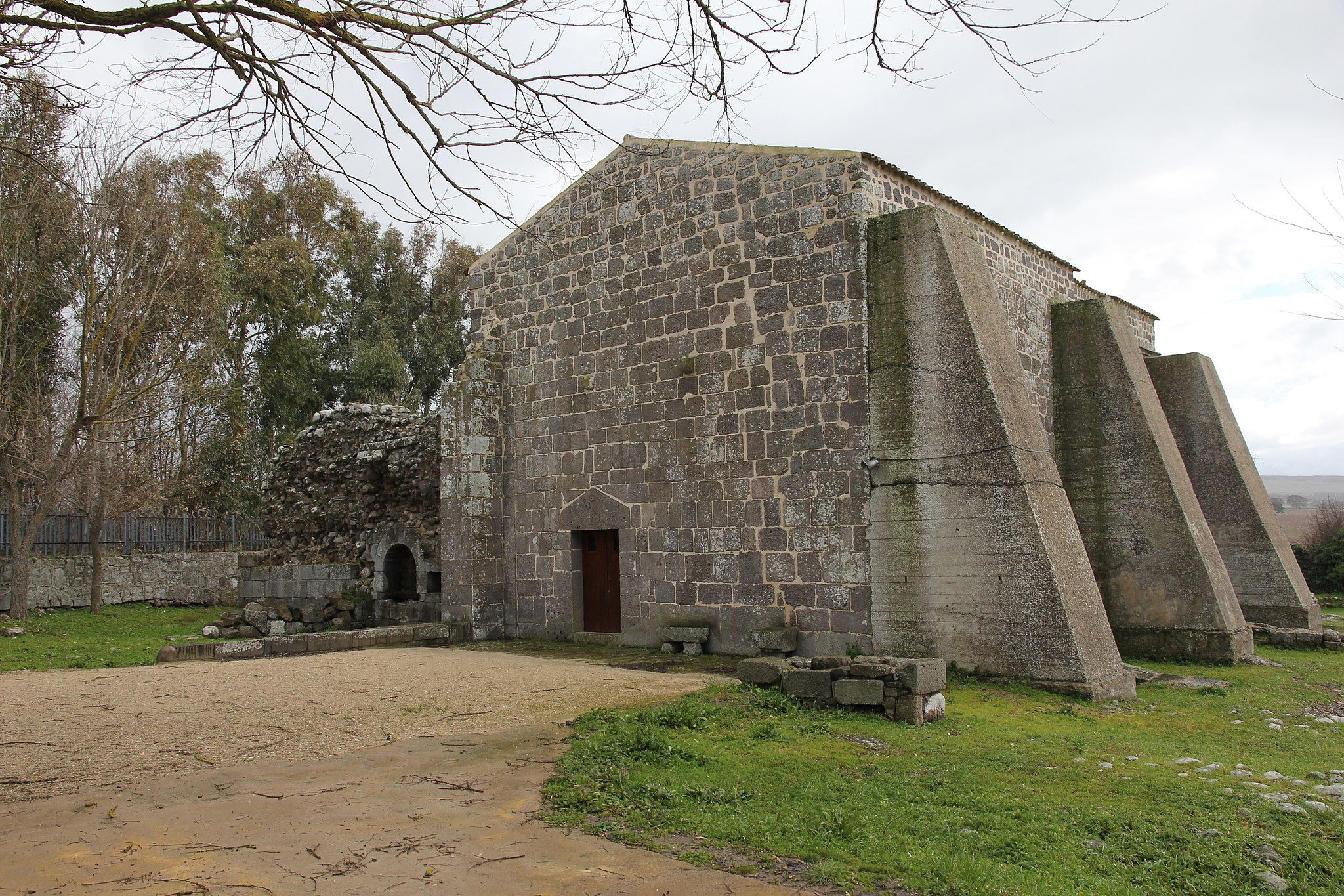
Santa Maria di Corte
It is the first and main Cistercian church in the Sardinian territory, evidence of the age of the Judicates, made up of wars, alliances, religious ferment and monasteries around which medieval village life revolved. Above all, it is the only remaining part of an abbey that reached its maximum splendour and then decline and ruin over just a few centuries. The church of Santa Maria di Corte is also known as Santa Maria di Cabu Abbas, from the name of the locality, a valley in the territory of Sindia - three kilometres east of the village - rich in springs and water sources. The sanctuary has lived two lives: the first began with the foundation commissioned by the judge of Torres, Gonario II, following an encounter with Saint Bernard of Clairvaux. The term 'corte' (court) contained in the name is, in fact, the result of the sovereign’s direct desire to build the abbey. Gonario asked and obtained, from the abbot, the arrival of monks and workers to build the complex and, in exchange, he granted large portions of land between Planargia and Marghine.
Between 1147 and 1149, the abbey was built and consecrated. The monastery became an economic centre, attracting farmers and artisans thanks to the ‘granges’, self-sufficient farms managed by the monks, but sources tell us that shortly thereafter, already at the end of the 13th century, the abbey complex was in complete crisis. The church and monastery were abandoned around the middle of the 15th century: the abbey was closed down by the Pope and the buildings were almost completely demolished to make room for other buildings. The sanctuary’s second life began at the beginning of the 17th century, when the renovation of the original transept began and new rooms were added, ‘converting’ the surviving building from scratch into a church. Thanks to the excavations and the evident traces on the ground, it is possible to reconstruct the layout of the entire building made from trachyte and dark basalt: the church had three naves, a crux commissa and a quadrangular apse. The cloister opened on the south side, surrounded by spaces used by the monks. Today, you can admire the southern part of the transept with two chapels, a vaulted room - perhaps used as a sacristy -, and part of the raised choir. On the right side, you will notice three buttresses, between which a portal with a rounded arch opens up between the first and second buttress. The chapels are barrel vaulted and each of them contains a single lancet window.
The abbey was destroyed also as a result of the popular belief that the monks were hiding rich treasures there. According to a legend, there is a second underground church, with a golden statue inside it protected by mysterious rituals preventing it from being found.
The celebration of Santa Maria di Corte is deeply heartfelt by the people of Sindia: on the eve of the celebration, su Izadolzu takes place and is a common vigil in which food and drink is offered. 8 September is the real day of the celebration, with a solemn procession, dances and shows.

Guarding enchanting locations
From the coast of Villasimius to the Marina di Tertenia, you can walk across picture postcard beaches and unspoilt coves. These were once the scene of dramatic Saracen raids and tireless, epic defence by soldiers and village populations, thanks also, and above all, to the coastal fortifications. You will often find them still in excellent condition, spectacularly towering over promontories and cliffs, offering unforgettable views every time.
Itinerary: 92.5 km
Journey time: about 19 hours, spread over four days
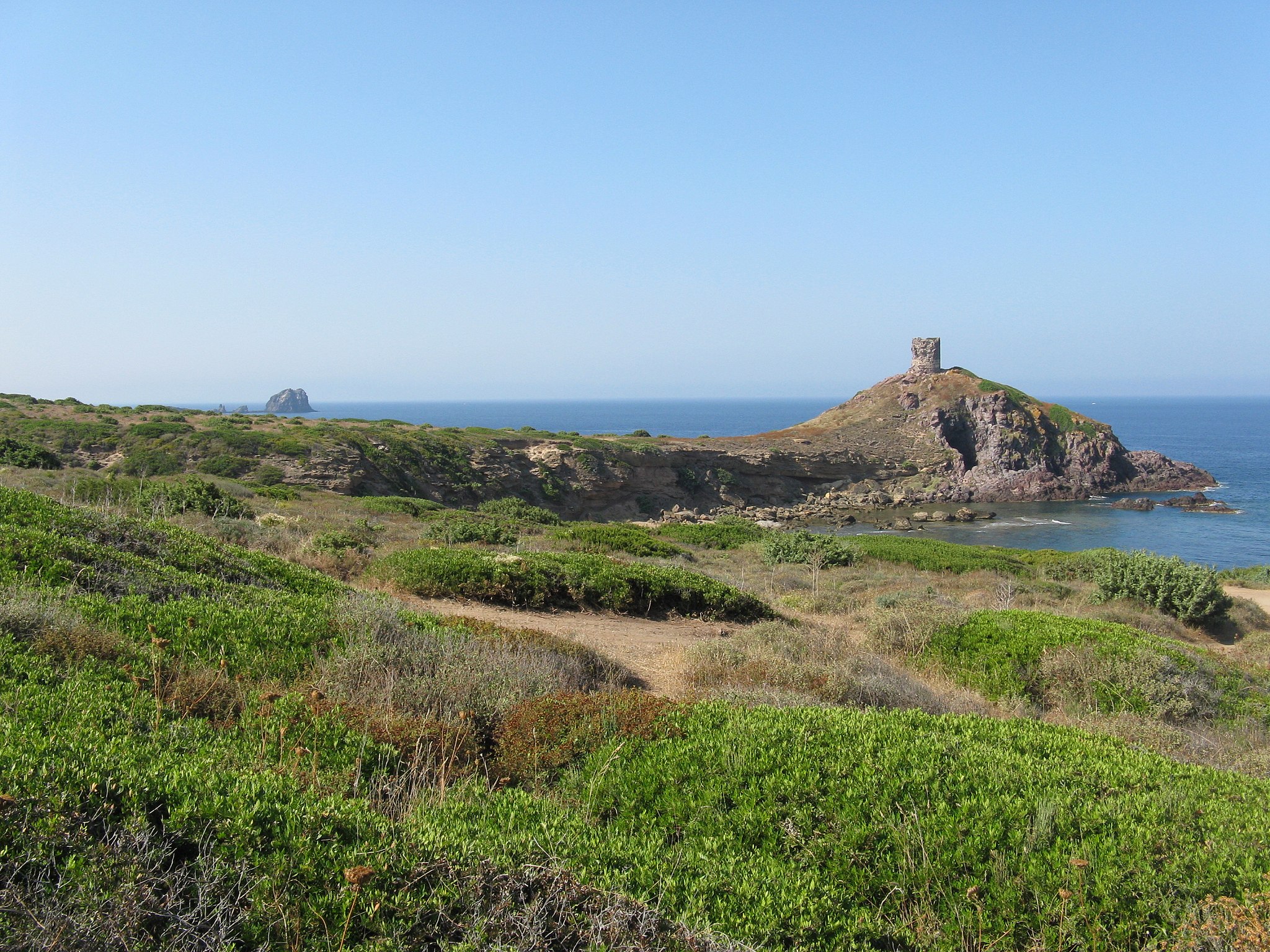
Towers with a view of the open sea
At the foot of provincial road SP 49, one of the most beautiful scenic roads in Sardinia, your journey will begin along stretches of wild coastline, picturesque villages by the sea, natural oases and rural churches surrounded by countryside. Linking the various legs of the journey as far as the Sinis peninsula are ancient watchtowers built during the Spanish domination, once a bastion against pirate attacks and today spectacular, romantic observation points looking to the west, especially at sunset when the sky is filled with warm colours.
Itinerary: 92,5 km
Journey time: 19h30 spread over five days

Sulcis-Iglesiente, amidst towers and mines
For centuries, the natural bays and harbours of the southwestern corner of Sardinia saw ships leave with their cargo of minerals extracted in the mines. Those same coves were sometimes threatened by pirates and invaders, and defended by fortresses built in strategic points. From Buggerru to Sant'Antioco, you will follow a path that retraces fascinating pages of history, the traces of which mark and embellish an area of infinite natural and scenic beauty.
Itinerary: 75.5 km
Journey time: 13 hrs 30 mins spread over 3 days

The mysterious charm of Nurra
Every people left something here: traces of buildings, artefacts, names of streets or places, traditions and legends. From Alghero to Porto Torres, different universes cross each other in a few square kilometres. Along the coast, dotted with watchtowers, your journey is a combination of picture postcard natural scenery and stories from a past, each of which somehow continues to live in the present.
Itinerary: 99.5 km
Journey time: 21 hrs spread over five days

Along the way of angels, martyrs and pirates
On the southern coast of Sardinia, where ancient peoples built fortresses, roads and towers, in places where the legend of the island’s most beloved saint was born, there is a path dotted with rocky lookout posts dominating the coast from up above on spectacular promontories. You can admire them, along with churches, archaeological sites and aristocratic villas, next to a sea painted with intense shades of blue.
Itinerary: 108 km
Journey time: 23 hrs spread over six days
From the granites of Gallura to the towers of Baronia
Departure is from Vignola Mare and arrival is at La Caletta di Siniscola, passing through the well-known towns of the Costa Smeralda. You will follow an itinerary that takes you into the heart of Gallura and shows you every aspect of it. The link between them is represented by the coastal defence towers, built in the north and the east by the Spanish Crown to oppose the barbarian incursions. Today, they embellish the landscape as they look out onto heavenly beaches and picturesque seaside villages.
Itinerary: 160 km
Journey time: 33 hrs, spread over 6 days
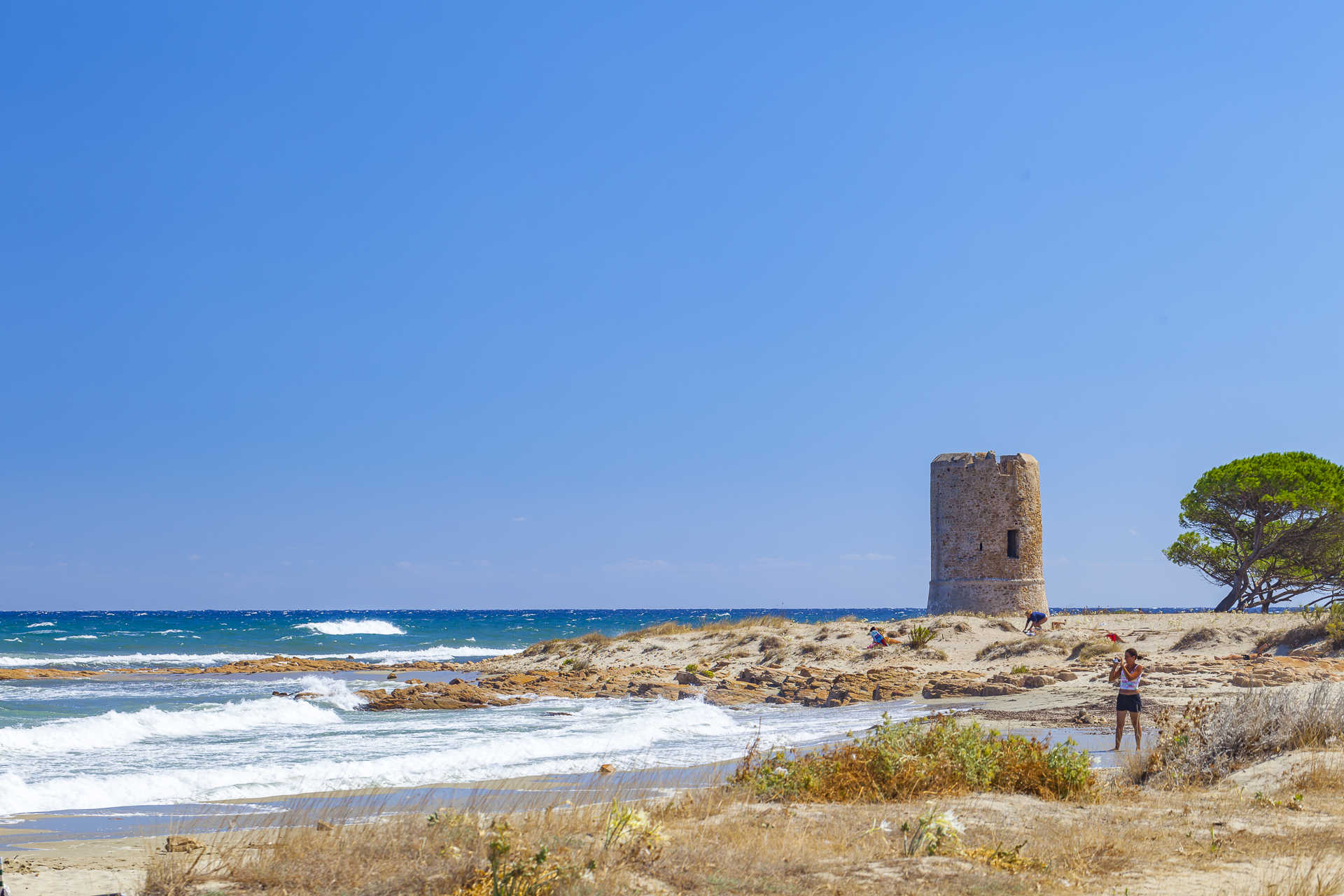
Sa Rocca Tunda
A wide expanse of pale grey sand, crystal clear waters and soft sand dunes behind it, a view that you will never want to stop observing, in absolute tranquillity. Sa Rocca Tunda stretches along the foot of Capo Mannu, in the northern part of the Sinis peninsula, next to a small village of little houses and dirt roads in the San Vero Milis area. The beach is about a kilometre long and part of the protected marine area of Sinis and is washed by a turquoise sea that takes on more vibrant colours offshore. The left side of the beach is delimited by the promontory of Capo Mannu. In front of it, the islet of sa Tonnara appears and, to the right, there is the cliff of su Crastu Biancu, beyond which you will have a view that stretches from the northern coast of the Oristano area all the way to the ‘costa dei grifoni’ (coast of the griffons) at Capo Marargiu. On the opposite side, behind the promontory, another rocky offshoot stands out, dominated by the remains of the Capo Mannu tower, built in the Spanish period (16th century).
A refreshment area is the only service in this wild and uncontaminated place. In fact, Sa Rocca Tunda is ideal for those seeking relaxation and tranquillity away from the chaos of the most crowded holiday resorts. Large spaces and shallow waters make it suitable for families with children. The transparency of the sea also attracts snorkelling enthusiasts, while the Sale Porcus pond behind it, populated by various species of birds - including pink flamingos - invites you to dedicate some time to birdwatching.
Around Capo Mannu, you will find numerous other unmissable beaches, which will take you on a real tour of scenic beauty. Almost in continuity with sa Rocca Tunda, towards the tip of the promontory, you will find su Pallosu, with its colony of cats. On the opposite side, a sandstone ‘barrier’ is located in the open sea a few dozen metres from a golden beach, creating an unusual landscape: it is Sa Mesa Longa, a real natural swimming pool with emerald green waters. To the south, in front of the village of Mandriola, lies the long beach of Putzu Idu, with its very shallow, blue and incredibly transparent waters. A spectacular cliff surrounds s’Arena Scoada, where rocks smoothed by the waves emerge, as well as sand mixed with quartz crystals and a sea reflecting shades of green and blue. Just before sunset, you can stop near the Capo Mannu lighthouse, at the foot of another Spanish tower, Turr’e sa Mora, to admire an unforgettable play of colours with a view of the island of Mal di Ventre.
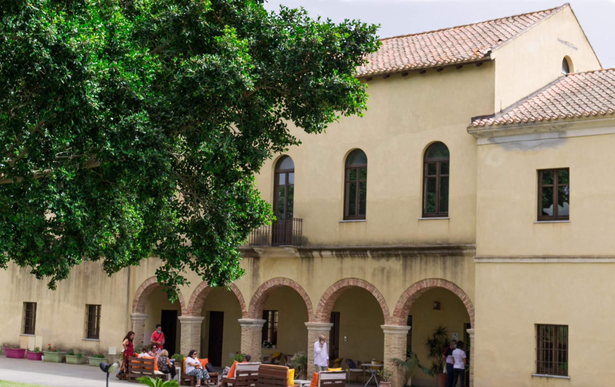
Casa Spadaccino
It was originally a railway station, then a manor house, after which it was abandoned for decades. Today it is a cultural centre. These are the four lives lived by Casa Spadaccino, a historic building a stone’s throw from the sea, at su Loi, a locality in the territory of Capoterra. It was constructed in 1873 by the French mining company of Petin et Gaudet, which held a concession in the inland mountains. It was located at the end of the ‘road of the Genoese’, an ancient coal merchants’ road on which a railway was installed. The building served as the terminus station for convoys loaded with iron extracted from the mine. In the 1930s, it became the heart of a thriving farm, surrounded by vineyards, vegetable gardens and orchards. The area was transformed into a large, colourful garden, where cutting-edge cultivation techniques were applied, so much so that it earned itself the nickname of su spantu, ‘the wonder’, which still identifies a small village not far from su Loi.
The urban development of the Capoterra coast led to the sale of much of the land, resulting in the decline and closure of the company. Casa Spadaccino - which owes its name to its last owner - was abandoned for decades, before being acquired and renovated by the Municipality of Capoterra. Today, the Laguna di Santa Gilla environmental and sustainability education centre is located inside it, along with the Laguna Museum (MuLAG), and it also hosts cultural events and shows. The exhibition is a journey through the natural and ecosystem-based aspects of the lagoon, also known as the Stagno di Cagliari. It also looks back at its relationship that evolved over time with the inhabitants of Capoterra. There are plenty of educational workshops and thematic programmes aimed at raising awareness about the lake environment.
The building consists of a single-storey central body, with an attic and an entrance portico with five arches, to which two other buildings, identical to each other, are attached. A large, sheltered garden offers peacefulness and a space for outdoor activities and events. You can combine a visit to the ‘house’ with an experience in close contact with nature on the banks of the lagoon. The lagoon environment extends for 1300 hectares between Cagliari and the territories of Assemini, Capoterra and Elmas. The wildlife that populates it is varied and fascinating for birdwatching enthusiasts, who can count on dedicated stations: you will see herons, hawks, black-winged stilts and above all pink flamingos, which have nested here for decades. You can walk along the paths around the lagoon, or ride on horseback or on a mountain bike.
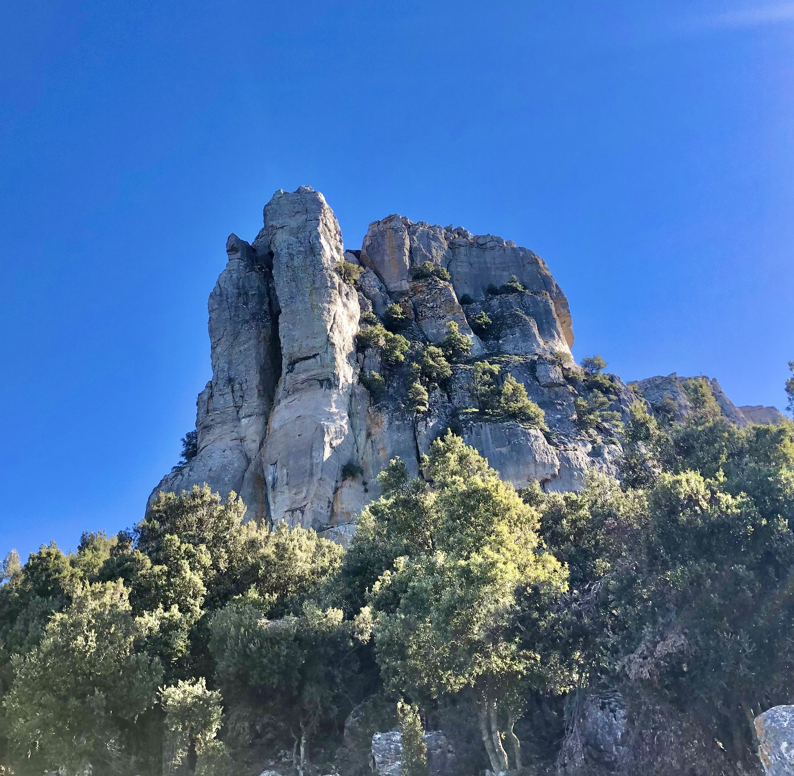
Monte Novo San Giovanni
A limestone ‘tower’ with spiers of up to 70 meters high, surrounded by rare endemic floral species, from which to enjoy a spectacular 360-degree view of both the Supramonte and Gennargentu massifs. That describes the spectacle of Monte Novo San Giovanni, a natural monument that stands at 1306 metres above the Montes forest, in the Orgosolo region, known as the 'village of murals' of the Barbagia of Ollolai. Seen from afar, it looks like an enormous bastion with an almost regular shape, a bit like the 'heels' of Ogliastra, but in reality the upper layer is broken into rocky blocks divided by deep cracks that are home to such endemic species as the ribes sardorum.
The view from here spans from the Gennargentu to the Supramonte of Orgosolo and Urzulei, from monte Corrasi to the gola di Gorropu, then to the Baronia coastline along the sea. You’ll see the full length of the Montes forest and the centuries-old sas Baddes oak woods, one of Europe’s oldest. At the top of Santu Juvanne, as it is known here, are two wooden huts. On the right looking south-east you’ll see Monte Fumai, another tall limestone tower vaguely shaped like a pyramid. The top reaches 1316 metres in height and it shares its geological origins with Santu Juvanne. The trail that leads to the natural panoramic terrace is accessible to all and an easy walk. It starts at the Montes forestry station and goes by the Funtana Bona natural springs, the source of the Cedrino river, and which, as its name suggests, is a source of pure clean water. The trail, which can also be enjoyed on a mountain bike, is shaded by oak woods and majestic holm oaks. Now and then you might even spot a mouflon, a local breed of mountain goat. Other local fauna includes wild boar, wild cats, dormice, martens, hares and foxes, while eagles, ravens and peregrine falcons circle in sky around the peaks of Monte Novo San Giovanni and Monte Fumai. Near the base of the tower the forest thins out, the rugged landscape comes alive with asphodels and rock roses and begins to open up: you may even see grazing herds along the bends before you reach a small section with stone steps that finally lead you to the summit.
The Montes forest bears traces of ancient settlements, like the Mereu and Presethu Tortu nuraghes near the sas Baddes woods, and the two Giants’ tombs at sa Senepida. At the feet of Monte Fumai are the remains of a pastoral village known as Norculanu, the setting of legends and popular tales that you can hear as you stroll along the streets of Orgosolo, decorated with murals.