
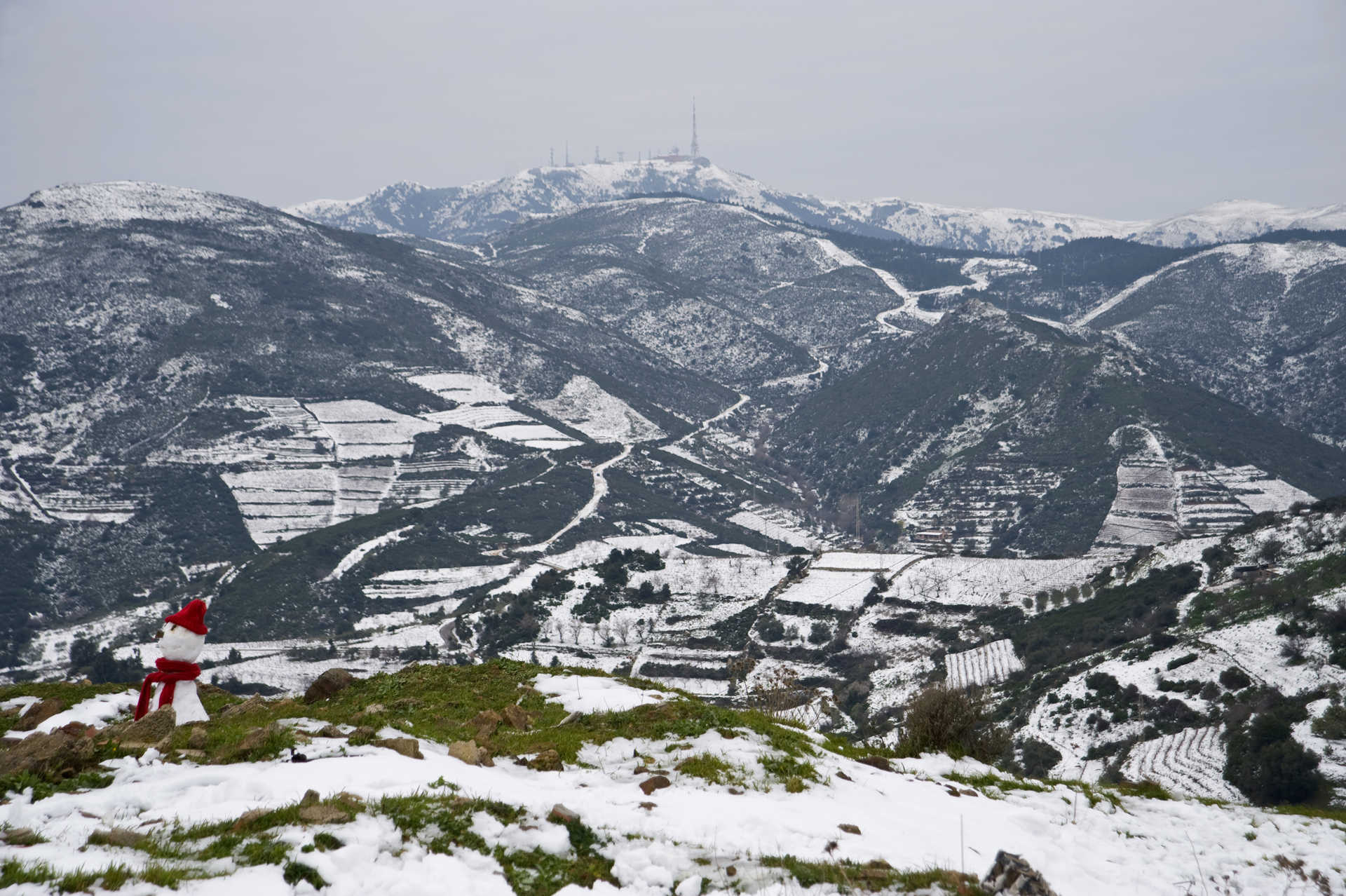
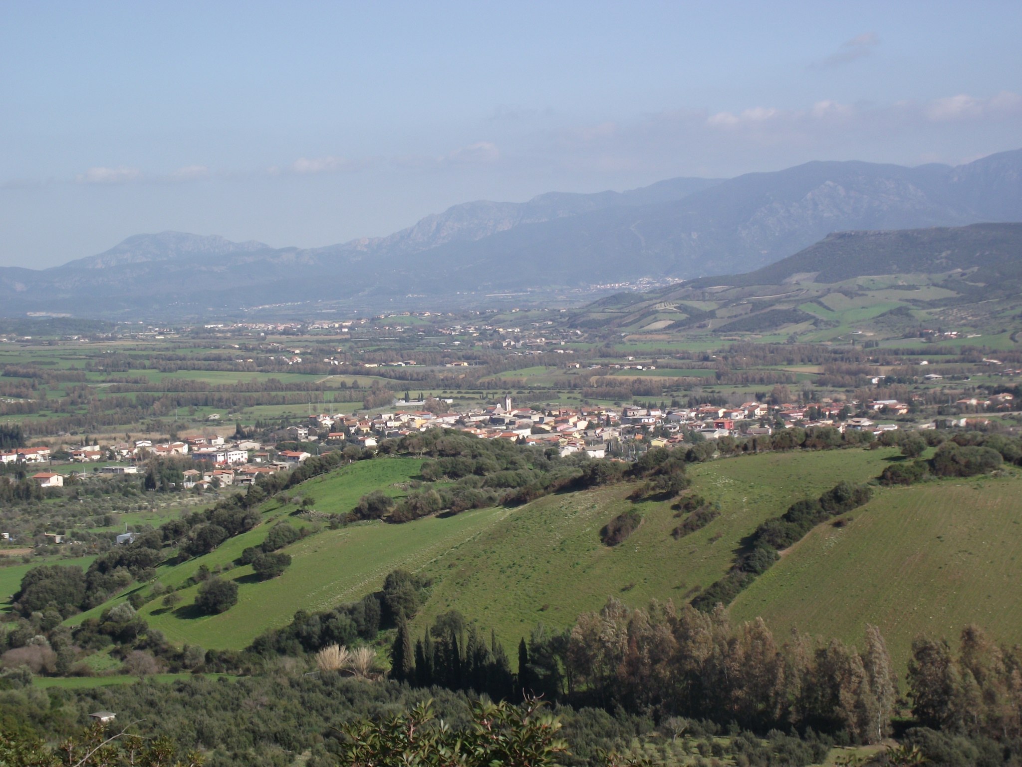
Burcei
Climbing up the eastern side of Monte di Serpeddì, at an altitude of 700 metres above sea level (compared to one thousand of the mountainous massif), is the town of southern Sardinia that has more characteristics and appearances of a mountain town. The name of Burcei, a Municipality of three thousand inhabitants, derives from burrei – a ‘herd of oxen’ – as a confirmation of the local pastoral tradition. The town arose towards the end of the 17th century when a number of families of breeders from Barbagia coming from Sinnai, Settimo San Pietro and Villasalto areas occupied the mountainous land, dotted with woods and springs, being particularly suitable for pastoralism, on which the local economy is still based. They settled near the spring Sa Mitza de su Salixi which, until the end of the 20th century, remained the centre of the town. The inhabited area preserves structures from the ancient Sardinian architectural tradition, which are clustered around three small piazzas. From the centre, an endless panorama can be admired, with views overlooking Cagliari and the Poetto beach.
The nearby countryside, as well as grazing, is used for vegetable gardens, grape vines, legumes, and above all, for its tasty and renowned cherries, protagonists of the local cherry festival in June. At the edge of the village, expanses of greenery can be admired for their fresh water springs, inebriating aromas and evocative views. This is the heart of the Parco dei Sette Fratelli, one of the largest and most fascinating natural oases of the island and of all of Italy. Along the valley of the Rio Brabaisu lies a forest of holm oaks and alders, inhabited by numerous species of rare animal species. Nearby is the Tuviois forest, which dates back hundreds of years. To the south of the town is the pretty gorge of the Rio Cannas, which flows between cascades, granite walls carved by water, and bushy and colourful oleanders. It is a land inhabited since the Bronze Age, as evidenced by the nuraghe edifices of Bruncu Entosu, Bruncu Moddizzi, De Su Attu, Dom’ e s’Orcu, Sa Serra and Su Nuraxi. Amongst the modern monuments, however, one highlight is the parish church of Nostra Signora di Monserrato, built in 1886 based on the design of the architect Gaetano Cima (a ‘design’ analogous to that of the Chiesa di Guasila) and characterised by an octagonal layout with side chapels, a neoclassical façade, being gabled and divided by columns, and featuring a tall bell tower. The patron saint of the village is celebrated on 8th September, whilst Santa Barbara is celebrated at the beginning of June. These are occasions on which to taste the specialties resulting from the local farms: excellent goat and sheep cheeses, exquisite cured meats and bread made from durum wheat semolina, cooked in a wood oven. Another unmissable event to taste delicacies is the Sagra de sa Pezza de Craba (a goat meat food fair) in August.

Cala d'Arena
Cala d'Arena is the most northern beach of the island of Asinara and perhaps its most beautiful, divided in two during the winter by a small brook. to the rear stands a coastal tower dating back to the Sixteenth century. Up to a few decades ago the Loggerhead sea turtle laid its eggs here, and it was also possible to sea some specimens of the monk seal. The beach has brilliant white sand, surrounded by Mediterranean brush and its waters are unbelievably crystal clear. Cala d'Arena is a conservation area mainly due to its extraordinary natural beauty, found in the colours of the sea and in the harsh and evocative rocky areas that alternate with the white sand. A little more to the north of the bay we find the lighthouse of Punta Scorno, that marks the northern extremity of the island of Asinara.
Perdaxius
It’s place name means ‘rocky or stone quarry’ and reflects the lay of the land and the abundance of rocky materials in the surrounding hills, including Monte s’Orcu. Perdaxius stands on a flat area crossed by a stream of the same name, in the heart of the limestone basin of Sulcis, an area rich in galena, once extracted in the mines of Peppixedda and San Simplicio. Now abandoned, they represented the town’s main income for centuries. Now, the town lives off shepherding, quality cheese making (goat and sheep milk cheeses); wine making (carignano, monica and cannonau wines); and the production of high quality leather, used by top designers. The local art of ‘bread making’ is closely linked to the cycle of life and celebrations: civraxu, cocoi, a bread with an egg typical of Easter, and pani de sposoriu, for important ceremonies, stand out. The local culinary traditions are also renowned, including excellent meats (beef, piglet, lamb, sheep and kid) and sweets, including bianchinus, gueffus, pabassinas, pardulas, pirichittus and pistoccus.
The Municipality of Perdaxius, independent since 1958, includes 14 small hamlets – Mitza justa, Is Manais and Is Pistis being the biggest – where about half of the 500 residents of the municipality reside. This reflects the town’s origins as a grouping of various isolated villages. The main village was founded after the year 1000 by Franciscan monks, conquered by the Pisans, passed under the control of the Giudicato of Cagliari and finally, under the control of the Crown of Aragon. Petrargio or Perdacha, abandoned by its residents in the 15th century to escape pirate raids, was repopulated and reorganized in the 18th century. The houses, which originally stood around a monastic settlement, now line a network of roads that gravitate towards the new Parish of San Giacomo (1959). A 13th century Pisan Romanesque church is also dedicated to Saint Giacomo, whose feast day is celebrated in late July (along with Saint Anna). Now restored, it has a façade of brown volcanic rock, topped with a bell-gable. It is the most important architectural site in the area along with the Romanesque church of San Leonardo, which stands in the town’s outskirts among century-old olive trees and has a façade rebuilt in the 17th century. Paintings dating to the Spanish period on the doors of the wardrobe housing the saint’s simulacrum are of note. Celebrations in his name are held on the Sunday of the Pentecost. Su Corrali, a Benedictine monastery in the hamlet of Pesus is also worth a visit.
The fertile lands and abundance of mineral deposits have drawn settlers since prehistoric times. The area contains the Camboni Nuraghe, not far from the town, and the nuraghe of Mount s’Orcu. Traces of burials in natural cavities near Su Moinu de Perdaxius also date to the Bronze Age.
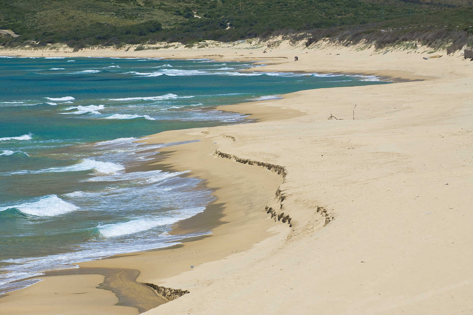
Beach of Buggerru
It appears to the right of the modern little tourist harbour, with light reflecting on the sand and splendid blue waters. The beach of Buggerru is a soft and welcoming expanse washed by a transparent sea of iridescent colours, which often receives awards from Legambiente (Italian environmentalist association) and the Touring Club. The waters are shallow and the seabed is sandy.
The beach is very close to the residential area, so all the main services are at your disposal. Buggerru, a former mining village, emerged in 1864 and is concentrated on the floor of a valley that looks out to sea. At the end of the 20th century, it became a tourist centre, thanks also to the port, overlooked by the exit of the Galleria Henry, through which a steam train once travelled, carrying the mineral extracted from the nearby mines, now a tourist attraction. Its coastline is low and sandy, as far as Capo Pecora, the southernmost locality of the Costa Verde (Arbus), and is protected by high dunes.
Among the nearby beaches, don't miss a chance to visit the wonderful inlet of Cala Domestica, a dreamy gem set between the white limestone cliffs, located in the south, in the middle of the former mining area. To the north, there are the large dunes of San Nicolao, behind which there is an impressive area of reforestation of pines, a perfect stretch for mountain bike excursions and, further up, in the territory of Fluminimaggiore, there is Portixeddu (or beach of Rio Mannu), featuring ochre-coloured fine sand and delimited to the north by a cliff that favours the formation of natural pools.
Villamassargia
It lies in the valley of the Cixerri river, surrounded by the hills of the Iglesiente region. Villamassargia is a village with fewer than four thousand inhabitants, in which ancient textile traditions are still intact: numerous artisan workshops produce rugs, tapestries and household articles. The creation of objects made of wrought iron and wood is also remarkable. The agri-food products are of excellent quality: from cheeses to olives and olive oil, bread and pastries. In the old town centre, there are typical agricultural-pastoral houses next to two religious buildings. One is the parish church of Madonna della Neve, originally built during the first decade of the 12th century by the Benedictines and today it has a Gothic-Catalan style, resulting from the various phases of its reconstruction between the 14th and 16th centuries. The second one is the church of Nostra Signora del Pilar, that offers an uncommon factor in Sardinian medieval art: from an epigraph on the facade, not only can the date of its construction be obtained (1318), but also the name of the builder (Arzocco de Garnas). It was first named after San Ranieri, celebrated at the beginning of September. The façade, which is Romanesque style, has maintained its original appearance, in sedimentary rock, with a depiction of Eve with the snake. There is a beautiful rose window over the entrance portal.
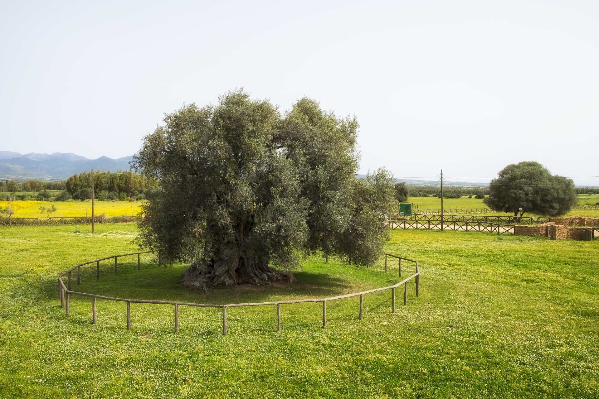
Villamassargia reached its maximum splendour during the Middle Ages, when it became the capital of a curatory in the Guidicato of Calari. The Castle of Gioiosa Guardia, dates back to this period and its ruins are located on a hill four kilometres from the village. The name indicates the role of control it held over the valley of the Cixerri river. It was built between the 12th and 13th centuries and is made entirely of andesite, at the behest of the counts Della Gherardesca. It was later possessed by the republic of Pisa and, in the end, it was absorbed by the Aragonese. At the foot of the fortress, there is an open air museum, S'Ortu Mannu, where there are more than 700 majestic centuries-old olive trees, transplanted there between 1300 and 1600, with robust and knotted twisted trunks. One of them, Sa Reina, has a trunk of over 16 metres in diameter, a natural monument. At the end of October, the feast of the olives takes place in the park.
Villamassargia participated in the mining epic of Sulcis. The greatest legacy of industrial archaeology is the mine of Orbai, nestled in a forest and already used in the Roman era and abandoned in the nineteen sixties. Lead and zinc were extracted there. The territory is also dotted with archaeological sites, from the Ancient Neolithic period, as is confirmed by materials found inside the grotto of Corongiu Acca. The numerous Nuraghi date back to a later period (2nd millennium BC) among which Santu Pauli and Monte Exi, Tombs of Giants of Mount Ollastu and several sacred wells. An aqueduct and foundries date back to the Roman period.

La Punta
The beach of La Punta has rocks and vertical cliffs which plunge into the sea. Its waters are an intense sky blue and its rocks, both dark and pinkish, form evocative plays of colour. From high up on the promontory, one can admire an enchanting view, that takes in the coasts of the Sulcis, the Isola Piana and the Isola dei Topi, along with an old building in which tuna was prepared and packed, a fish which today is mostly exported to Japan.

Neoneli
Spread across the green hills in the heart of the island, a short distance from the scenery of Lago Omodeo, is one of the largest artificial basins in Europe, with the environment, nature, culture and traditions having rendered it an authentic Italian village. Neoneli is a small town with around 700 inhabitants in the historical territory of Barigadu, documented in the late Middle Ages as Villa di Leunelli (‘Neunelli’), which today owes part of its fame to the Neoneli choir, a polyphonic quartet interpreting the archaic cantu a tenòre, also celebrated thanks to artistic collaborations with the singer-songwriter Francesco Guccini and with the group Elio e le Storie Tese. Adding to the prestige of the town is the wildlife oasis of Assai, almost a thousand hectares of land on the slopes of Monte Santa Vittoria, covered by dense forests of holm oaks and cork oaks and populated by deer and fallow deer. Within the park is the museum of the oasis that exhibits various stuffed exemplars of species of mammals and birds, including raptors and a splendid golden eagle specimen.
The town is characterised by houses in red trachyte, a common local stone, with windows in the Aragonese style and adornments in basalt. These are flanked by artisan workshops, where cork carvers, leather workers and blacksmiths create artistic pieces produced to this day according to ancient techniques. These including Sos Corriolos, masks worn during the ancestral seremonies of the famous Neoneli carnival. A bonfire is lit in the central square, around which propitiatory dances take place. At the centre is the parish church of San Pietro, built in 1611, with its façade in pink trachyte. Within is housed a precious 15th-century silver monstrance and two wooden statues. Highlights on the rich calendar of events are the festivities in the town church of Sant’Angelo (‘s'Angelu’) celebrated in August, and that of Saint Antiocho martyr held two weeks after Easter. The religious processions are surrounded by folkloristic shows, market-exhibits and the famous music of the canti a cuncordu or sa neunelesa. Amongst the village festivals, the Sa Festa de Sa Fregula Istuvada and de Sa Cassola at the beginning of October are not to be missed. Fregola pasta cooked in broth and topped with various layers of pecorino cheese and lard is an excellence of local cuisine based on the local agricultural-pastoral tradition, consisting of simple dishes and intense flavours. There are a range of traditional sweets, often tied to the festivities: tzipulas for carnival, amarettus, seadas, sospiri, soft almond paste pralines, on the occasion of weddings and solemn ceremonies. Unmissable in late September is Licanias, the ‘culture and flavours’ of the rural landscapes, the same inhabited by the Neolithic culture, as evidenced by the Domus de Janas of Puleu, Pranu-Sasa and Su Angiu. The ruins of the Nocurreli, Olisetzo and Pruna Nuraghe date back to the Bronze Age.
Licheri Watermill
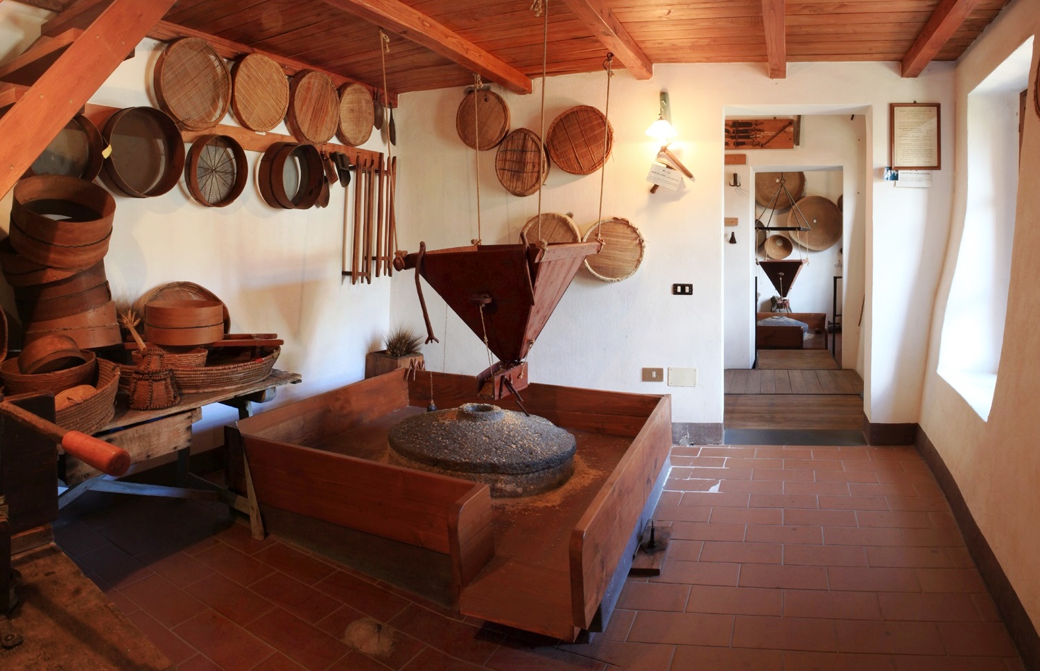
Fluminimaggiore was established in 1704, following an act of vassalage. At that time, its inhabitants chose to make the most of their main natural resource, the Rio Mannu river, by building mills along its course: in the second half of the 19th century there were 21 of them! One of them, built as early as the mid-eighteenth century, now has a new life. It is the Licheri mill, which currently accommodates the ethnographic museum set up by the Municipality of Flumini, with the collaboration of the population. Its millstones are still perfectly functional, despite the fact that almost three centuries have passed since its creation: the exhibition set up inside narrates its 270-year history, where you will come into contact with ancient trades and customs linked to the agro-pastoral cycle of life.
You can get to the mill by crossing a wooden bridge: the external structure is divided into three parts with ladiri masonry (mud and straw bricks) and reed roofing. Ploughs, harrows and an olive press wheel are on display in the courtyard. Under the main building, the water wheels moved (and are still operational) the two millstones, located inside two niches. The indoor museum exhibition consists of ten rooms: you can admire tools for wine-making and oil production, with a press made of chestnut wood; a room dedicated to blacksmiths and farriers; a bread oven and tools for cheese-making; a weaving room and several rooms reconstructed as domestic environments, kitchens and bedrooms. Rooms 3 and 4 ‘tell’ the story of milling, starting from Nuragic finds and ending with an electric mill from the 1930s. You will be impressed by the large silos made from woven reeds, designed to contain cereals. The millstone is formed by two overlapping basaltic stones: the lower one, su koru, is stationary, while the upper one, the tunica, rotates as it is connected to the water wheel set in motion by the current of the river. Hanging on the walls, there are tools used by housewives to sift flour, a sieve and a wooden frame. The last room contains an ox cart and a carriage from the late 19th century. There is no lack of interaction with children: they will be able to experiment with various tools and discover toys from the past.
On the subject of activities from the past, a ruin from the historical mining period, the ‘ghost’ village of Malacalzetta, appears in the lush woods. Fluminimaggiore is not just industrial archaeology, but also Punic and Roman, thanks to the Temple of Antas, one of the monuments that best represents Antiquity on the Island, standing in a lush green valley. Then there is a masterpiece of nature: five kilometres from the town lie the enchanting su Mannau caves, with rooms dotted with stalactites and stalagmites of various shapes and embellished by little lakes. Lastly, there’s the sea: the beach of Portixeddu with its seaside village is the other great attraction of Flumini.
Turcus e Morus Multimedia Museum
Legendary figures, legends and tales of battle, assaults and brave defences: the most violent of times in Sardinia’s history are marked by vicious pirate invasions and are on display in a unique exhibit. The Turcus e Morus multimedia museum in Gonnostramatza is housed in the halls of the former monte granatico. The idea of bringing to life the dramatic era of invasions carried out by the fearsome Saracens comes from an epigraph preserved in the church of San Paolo, two kilometers from the town. Here you can see proof of the destruction of the nearby town of Uras de manu de turcus e morus e fudi capitanu del morus barbarossa (by hand of the Turks and Moors led by the Moorish pirate Barbarossa) on 5 April, 1515.
This historic invasion is the starting point for the telling of the events that spanned ten centuries (the 8th to the 18th) on the coasts and inlands of Sardinia. The multimedia tools have the protagonists themselves telling the stories they played a part in, with interactive touch screen video-portraits, life-size holograms and the reconstruction of coastal towers - built by the Spaniards to combat the pirates – as well as naval bridges on which the figures of the pirate stories move about. You can also see dioramas, models of boats and period weapons.
One of the halls houses the digital reproduction of the retablo dell'Annunciazione, painted in 1501 by Lorenzo Cavaro, the man who started the Stampace school of Cagliari. The original hangs in the parish church of San Michele Arcangelo. Among the animated figures you will see and hear are Barbarossian pirates, Christian slaves and Sardinian tower fighters, as well as Barbarossa himself and the others that took part in the historical events that plagued the Mediterranean between the 15th and 17th centuries. You will explore the village of Sèrzela, now vanished but described via archaeological remains and descriptive videos, home to the last remaining vestige, the little church of San Paolo. The village was a refuge for those inhabitants of Uras who survived the onslaught. The museum periodically organises educational events, and is accessible to the handicapped and the visually impaired.
Aside from the parochial church, built between the 17th and 18th centuries over a Gothic-Aragonian structure, and the old parochial church of Sèrzela dedicated to San Paolo, Gonnostramatza is also home to the little 16th century church of Sant’Antonio Abate, set along the old main road that connected with the nearby villages. The town is a member of the sa Corona Arrubia consortium, founded to raise awareness of the local archaeological remains, the most important of which is the Eneolithic tomb known as Bingia e Monti, where the oldest gold coin ever found in Sardinia was unearthed.

Sini
Dominated by the imposing but evocative silhouette of Giara Park, it peeks from between lush, rolling hills, from which visitors can enjoy a view over fascinating scenic cliffs covered with almond groves, vineyards, century-old olives and cereal fields. Sini is a small town of 500 inhabitants that lies in the portion of Marmilla belonging to the Province of Oristano, from which it is over 60 kilometres away. The place name derives from sinu, a reference to the cove where the town is located. During the Medieval period, the town was part of the Giudicato di Arborea, while during Aragonese rule it was first the property of the Baron of Tuili and then of Marquis Laconi.
The municipality of Sini includes part of Sa Jara Manna (the Giara), a basaltic plateau of volcanic origins home to wild horses unique to Sardinia. A wild and uncontaminated place that has no parallels, it is an ideal setting for hiking, biking and horseback riding. Another of Sini’s naturalistic jewels is the Park of Cracchera, embellished during less arid periods by the Su Strumpu waterfall.
In the town centre, stand the Parish of Santa Chiara d’Assisi, whose patron is celebrated in mid-August, and the ancient Church of San Giorgio Megalo. In late April, the town comes alive with a celebration in the patron saint’s honour marked by folklore events, craft exhibitions and above all, the Festival of Su Pani ‘e Saba. The festival, an opportunity to try this delicious sweet of almonds, raisins and sapa, attracts thousands of visitors every year.
The extremely fertile and welcoming lands surrounding Sini, which currently lives mainly of farming and shepherding, is dotted with prehistoric and Roman sites where tombs, pottery and coins have been found. Seven nuraghes can be visited: Bruncu su Sensu, Buccascala, Perdosu, Scala ‘e Brebeis, Sedda, Siorus and Bruncu Suergiu, on the Giara, near the border with Genoni. Around the latter, the remains of a Punic-Roman settlement can also be seen.