

Punta Li Paddimi
The coastline of Castelsardo is formed from imposing red trachyte cliffs which every now and then boast a number of different shades, from dark to the lightest of reds. Not many beaches are found here but all of them are extremely beautiful, accentuated by the wild aspect of the landscape. The beach of Punta Li Paddimi, bordered by a brown reef, is a narrow bay covered with multi-coloured pebbles lapped by a limpid crystalline sea with splendid blue and emerald-green reflections. A number of flat rocky outcrops appear here and there on the shore.
Antiquarium Arborense
Representing the history of the city and territory of Oristano, it safeguards a precious heritage. The Antiquarium Arborense museum was founded in 1938 as the third museum in Sardinia, thanks to the Oristano municipality’s acquisition of the collection owned by Efisio Pischedda, a lawyer who, combining forensic activities with a passion for archaeology, pieced together the largest private collection on the island in the 19th century, composed of finds from Tharros and the Sinis peninsula.
Renovated in 2016 and equipped with a multi-touch table and wall plus interactive 3D models, the museum conserves a legacy consisting of some ten thousand cultural and archaeological assets, consisting not only of the Pischedda collection, but also of those of Carta, Sanna Delogu, Pau, Cominacini-Boy and D’Urso-Vitiello. The exhibition is housed in the elegant and neoclassical Palazzo Parpaglia, which has housed the Antiquarium since 1992, named after its first curator, Giuseppe Pau. The finds, which cover a chronological arc from prehistory to the Middle Ages, are flanked by two reconstructive models, the Tharros of late Roman times (4th century AD) and Oristano in the era of the Judicatures (14th century), when the capital of the Giudicato of Arborea was the protagonist of the island’s history.
At the time the city, current capital of the province of the same name, was embellished with palaces, churches and fortifications, all surrounded by walls, of which considerable traces remain to this day, along with the majestic Torre di Mariano (or di San Cristoforo). After visiting the Antiquarium, to learn more about the Giudici of Arborea, the cultural tour can be continued with a visit to the Museo della Sardegna Giudicale in the baroque Palazzo Arcais.
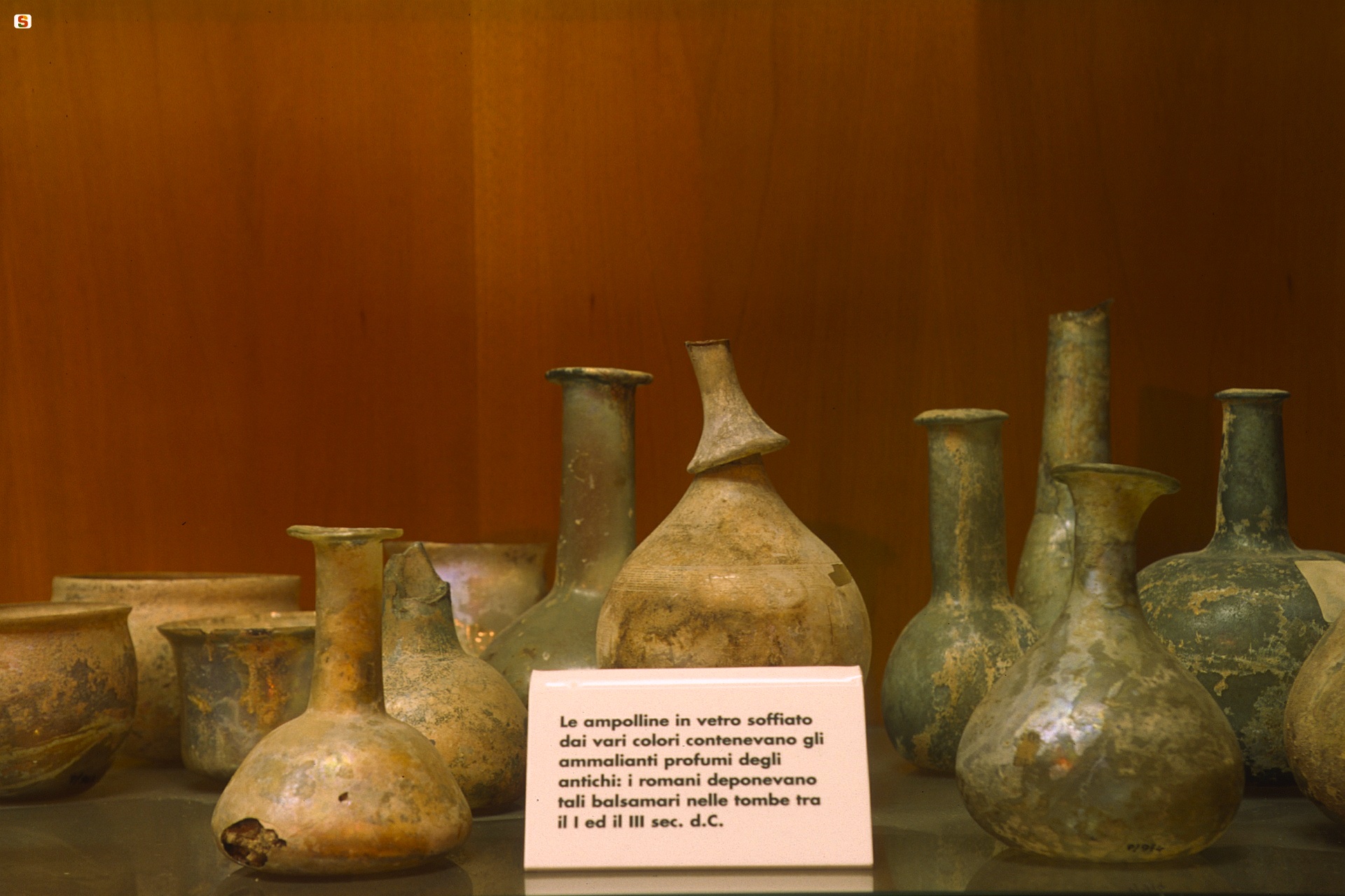
The ‘Parpaglia’ contains archaeological and ‘dei retabli’ (altarpiece) rooms, temporary exhibitions and the tactile museum exhibiting reproductions of artefacts from various cultural periods, which children and the visually impaired can ‘read’ with their hands. The room dedicated to the ‘sands of time’ offers a glimpse, as quick as an hourglass, that goes from the settlements from the ancient Neolithic times, hallmarked by the obsidian of Monte Arci, to the anthropisation in the middle and recent Neolithic age in Sinis, in Montiferru, Barigadu and the upper Campidano area. Widely documented are the pre-Nuragic and Nuragic civilisations, as creators of monumental architecture, bronze statues and, in Mont’e Prama (in Sinis), colossal statues of limestone warriors - preserved in the archaeological museums of Cagliari and Cabras - as are their interactions with other Mediterranean civilisations. The ‘highlights’ from trade between the peoples include a goblet of Attic-Mycenaean origin depicting Hercules fighting the Cretan Bull, a Carthaginian perfume burner which also depicts Hercules with a lion skin and the richest collection of Etruscan ceramics found beyond Etruria. The Phoenician and Punic ages (7th-3rd centuries BC), when Othoca (Santa Giusta), Tharros and Neapolis were founded, are represented by splendid grave goods. From the Roman and early Middle Ages (2nd century BC – 7th century AD), characterised by the development and splendour of pre-existing cities and the birth of the Forum Traiani, Cornus and Uselis, the most valuable finds are a collection of glass vases. The ‘antiquarian family room’ is dedicated to the lawyer Pischedda and family and to the archaeologist predecessors. The ‘sala dei retabli’ (‘altarpiece room’) safeguards three splendid Sardinian-Iberian paintings: Il Retablo del Santo Cristo by Pietro Cavaro (1533), the Madonna dei Consiglieri (1565) and the precious San Martino of the Catalan school (early-15th century). Also to be admired are ‘copies’ of artworks from the cathedral of Santa Maria Assunta and the church of San Francesco.

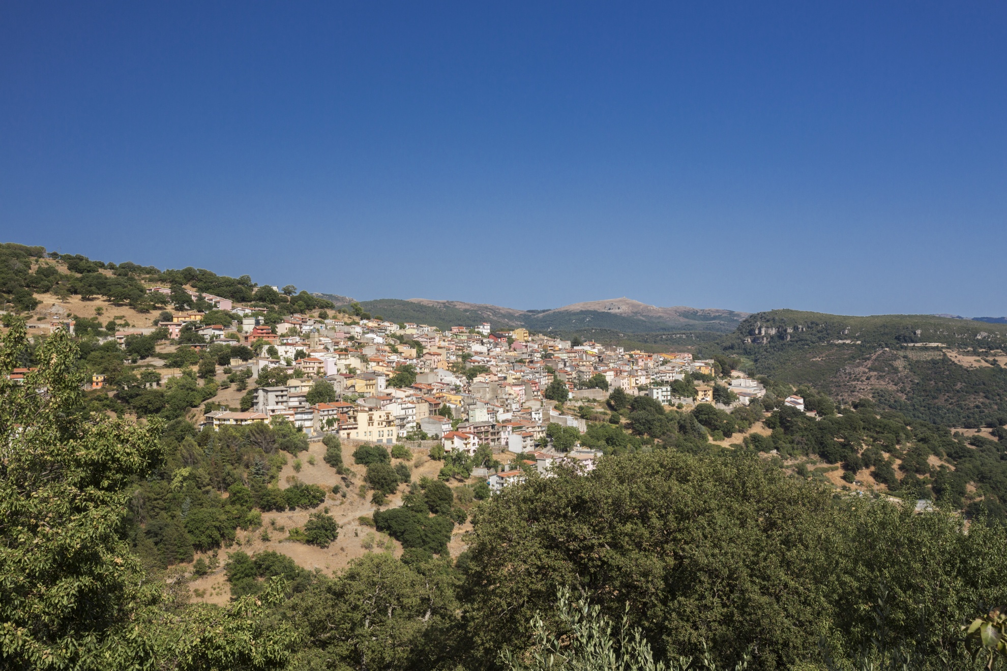
Padru
It emerged around 1700, perhaps already a Roman site, and became a Municipality in 1996. Padru is a small village in Gallura, with just over two thousand inhabitants, and its territory is on the border of the splendid park of the Oasis of Tepilora, which can be reached from its most distant and evocative district, Pedrabianca, with its houses made of stone and mud that climb up the white quartz rocks. From Sa Contra 'e S'Ifferru, there is a 360-degree view of the valleys, hills and mountains over half of Sardinia. From the village, you will reach evocative panoramic and naturalistic areas, with woods and springs, like the forests of Sa Pianedda and S'Ozzastreddu. From the 'terrace' of the peak of mount Nieddu (just under a thousand metres high) you can admire the splendid setting of the coast of San Teodoro and the Tavolara marine area. All the itineraries lead through large holm oak forests, cork oak forests and Mediterranean scrub, inhabited by mammals and birds of prey, like the golden eagle and hawks. In the autumn, the woods offer a generous variety of mushrooms. In the past, up until almost the end of the 19th century, the forests were practically impenetrable and, still today, the cork oaks create mysterious atmospheres. The territory is perfect for excursions on foot, on horseback or by mountain bike. You will find refreshments in the spaces equipped for picnics, cooled by the water from the springs, among which that of Sos Pantamos. Among the itineraries, in a land rich with rivers and torrents, you can discover the fluvial ones by kayak. Along the road that leads to the picturesque village of Pedrabianca, you can admire rocks with unusual shapes, like Sa Conchedda de Fizza Ona. Nearby, there is another extraordinary place: the Usinavà forest. From the district of Sa Serra, you will reach the little rural church of Sant'Elia, originally built in the 15th century. At the end of May, celebrations take place to honour the saint. All around, you will find a myriad of uninhabited villages, like Poltolu, with small granite houses, Baddevera and the Stazzi (rural settlements) of Avrio, Giuscherra Giuscherreddu and Piras.
You can combine archaeology with nature. About one kilometre from the residential area, in the direction of Olbia, there is the complex of Santu Miali, nestled in a splendid green setting. In a valley rich with woods, you will find the remains of a large Roman building (possibly a rural villa), a vast necropolis with 15 interments and the remains of two medieval churches, one of which featuring a bi-apsidal hall. As well as the substantial number of ceramic fragments, a 'group of coins' consisting of about 3500 minute silver coins was found in the tombs, as well as Roman coins and various necklaces.
Seulo
A pleasant, welcoming mountain town for which the surrounding territory is named. It is part of Sardinia’s blue zone: one of five areas in the world where lifespans are above average. Between 1996 and 2016 twenty centenarians have been recorded here. Seulo is the main town of the homonymous sub region of Barbagia, located on the border of southern Sardinia and Nuoro. The town, with its roughly 800 inhabitants, stretches at the foot of Monte Perdedu (1400 m), which is separated from Gennargentu massif by the Flumendosa river. If you follow the course of the river, it will take you past deep gorges, valleys covered by holly oaks and Mediterranean shrubs, limestone cliffs, springs, small lakes and rapids. Over the millennia, its waters have carved karstic caves inhabited since prehistoric times in the Addolì Forest. Some examples include Sa Ruta ‘e i Bitulleris and Sa Omu ‘e Janas, with a large hall full of stalagmites and stalactites. The most famous and characteristic spot is Su Stampu ‘e Su Turrunu, on the border with Sadali: a “water landscape” composed of a sinkhole, cave and a spring with a waterfall and small lake.
The Flumendosa also has a lot of drops, which have generated the waterfalls of Piscina ‘e Licona and Sa Stiddiosa, along the border of Gadoni, with water falling in a thick rush in the winter and a calm flow in the summer from plant-covered limestone into polished, rounded schists below. Combined forces of water and wind created S’Arcu ‘e Su Cuaddu, a natural dolmen under which a Domu de Janas was excavated. In order to bring attention to the natural beauty of Seulo, the Ecomuseum of Alto Flumendosa was founded in 2002. Excursions are grouped by theme: Andalas (trails), the most famous excursion, takes visitors to the coves and canyons of the river on August 13.
The town radiates from a 16th century Parish of Beata Vergine. However, the oldest church, the Church of Saints Peter and Paul, whom are honoured in June, is located in the upper part of the town. It is called the town of s’orrosa ‘e padenti, the “peony of the forest”, the main flower of Gennargentu, In the first warm days of spring, it paints the steep slopes of Perdèdu with reds and yellows. In April, a festival dedicated to this flower is held and guided tours to see the flowers are organized. In July, a Festival of Su Casu in Filixi, a unique cheese, is held. The town is also known for its bread and sweets. The cuisine is based on ancient shepherd tradition recipes and contributes to the longevity of the community. There is also a tradition of crafts: carpet weaving and knife making. Celebrations begin mid-January with Saint Anthony’s fires and offerings of wine and sweets. At the end of September, there is the Feast of Saints Cosma and Damiano, held in the country church named in their honour. In June, there is an unusual festival: Sa Tundimenta Seulese, the Sheep Shearing Festival. The area’s enchanting natural beauty safeguards archaeological treasures. Neolithic and Bronze Age walls and towers watch over the town: Domus de Janas, a Giant’s Tomb and some nuraghes, the closest of which are the smaller Su Nuraxeddu and the larger Su Nuraxi ‘e Pauli. The most important site, the Nuragic village of Ticci, stands on a plateau. A common characteristic of pre-nuragic monuments are cult chapels and this area is one of the most touched by this “cup-mark” phenomenon.
Barumini
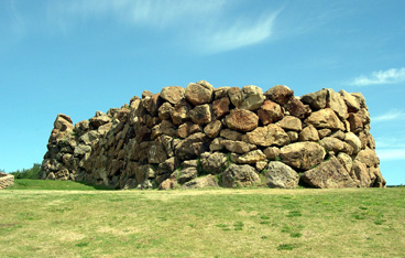
In the centre of the Marmilla region, in the valley of the Mannu river, at the foot of the Giara, there is a special atmosphere: ever since prehistoric times, Barumini was the main centre of a very rich territory, with a population of approximately one thousand 300 inhabitants today. It is one of the most captivating places of culture on the Island. At the entrance to the residential area, there is a monumental complex that has made it world-famous: Su Nuraxi, the only archaeological site in Sardinia declared a UNESCO World Heritage Site (1997). Not only is it the most impressive (and most well-preserved) of the thirty Nuragic sites, but it is, above all, the most precious inheritance left to us by the Nuragic civilization. The archaeological excavations took place in the middle of the 20th century by Giovanni Lilliu. The cultural centre located a short distance from the nuraghe was named after 'the father' of Sardinian archaeologists and events, concerts, and archaeological and crafts exhibitions (permanent and temporary) take place here, in this incomparable setting.
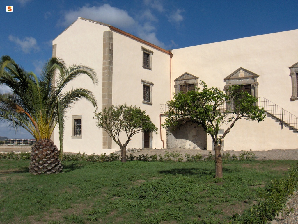
Su Nuraxi, made entirely from basalt blocks, reveals two thousand years of stratification, from the 16th century BC to the 7th century AD. It is a complex nuraghe, consisting of a bastion with a central tower (18 metres tall) and four corner towers. All around it, there is a maze of 50 huts (dating back to the Final Bronze Age), wells and cisterns. Another trilobed nuraghe also bears witness to the prehistoric origins of Barumini. and is located in the centre of the village, dating back to the 16th century BC, the Nuraxi e' Cresia ('nuraghe of the church') that was unearthed during the renovation of Casa Zapata, a splendid residence of the Aragonese barons (who arrived in Sardinia in 1323), built in the mid-16th century and a rare example of renaissance-inspired Spanish civil architecture. The noble palace, along with the garden and courtyard, have been the site of a museum centre since 2006, inside which two towers from the Nuragic monument are kept and can be viewed from above, thanks to suspended walkways and transparent floors. In the archaeological section of the museum (managed by the Fondazione Barumini Sistema Culture) there are 180 artefacts on show, found in the nearby Nuraxi. The other sections, set up in the rural courtyard, are historical-archival and ethnographic, where the regional museum of the Launeddas, traditional three-piped musical instruments, is also located.
Barumini was also inhabited in the period that followed, as is evident in the traces of walls from the Roman era. In the Middle Ages it was annexed to the Giudicato of Arborea: there are still beautiful examples of religious architecture in its old town centre: the ancient Pisan church of San Nicola and the 13th century church of San Giovanni. The basalt plateaus of the nearby Giara, the home of the famous little horses with a mysterious origin, is the best place for trekking and bicycle tours: you will be able to observe them as the gallop around the centuries-old cork oaks, downy oaks, holm oaks, Mediterranean scrub and little temporary lakes of Is Paulis.

Santa Maria della Neve
It sits on a hill the locals call sa tanchitta, outside of the historic quarters of Seuna and santu Pedru, a place much loved by the Nobel author Grazia Deledda. Santa Maria della Neve was constructed over the old and smaller church of Santa Maria Maggiore, which Bishop Giovanni Maria Bua decided to rebuild because it was too small to function as a Cathedral when Nuoro was elevated in rank to seat of a diocese. Although he blessed the cornerstone in 1835, a variety of events slowed the work down and it took almost twenty years for the new cathedral to be completed. The majestic building dominates a huge piazza. Twin towers stand on either side of the main gable.
The façade has four monumental granite columns topped by Ionic capitals that hold up the entablature. The perspective is closed by a triangular gable with a Palladian touch the designer, a Friar from Sassari named Antonio Cano who died tragically during construction, was especially fond of. The outer flanks are characterized by the lovely lines of the apses of the side chapels.
Technically speaking there is only one nave. It has a barrel vaulted ceiling and wide windows let in plenty of sunlight that then creates lovely chiaroscuro effects. But the three chapels on each side, each with an apse and covered by a hemispheric vault, communicate with one another via tall arches and so the effect is that of three naves and a cross-shaped layout. The raised presbytery is distinguished by a highly geometric structure where white marble, multicoloured stone and golden garlands alternate.
The area’s artistic flair comes to life and the church becomes the spiritual centre of the entire region around Nuoro during the last week of July and until the 5th of August, when religious festivities bring together local parishes and lay brotherhoods with those from ten towns in the surrounding province for masses, novenas and processions, culminating on the last day with a popular celebration dedicated to Santa Maria della Neve.
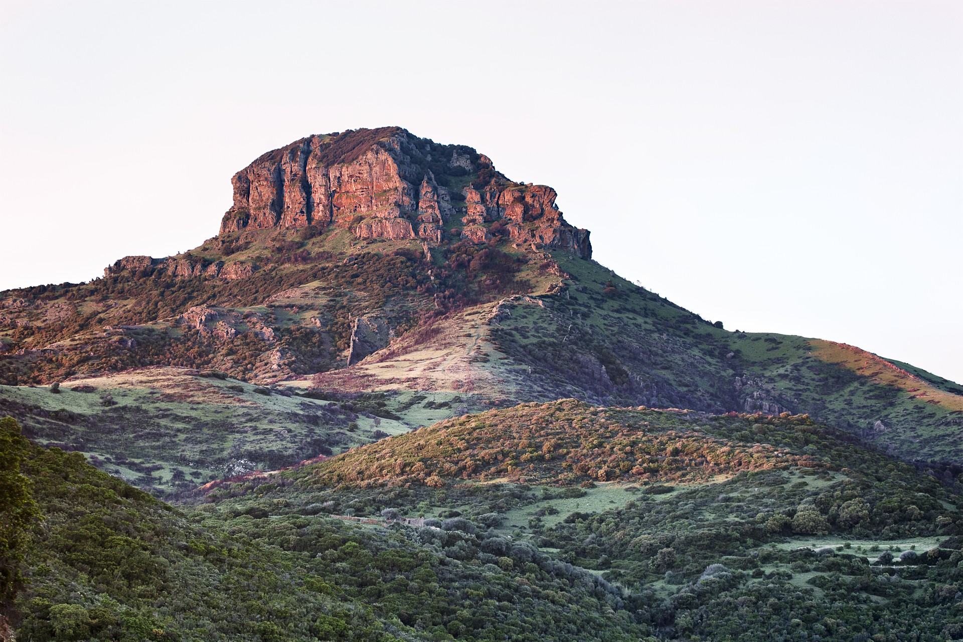
Monte Arcuentu
Arkù indicates the arched shape of the summit that, when seen from Piscinas and Scivu, looks like a dolomitic tower. The mighty Monte Arcuentu, a popular trekking destination, is part of a mountain range that runs parallel for eight kilometres to the beaches of the wild and wonderful Costa Verde. It is part of the territory of Arbus, which is eleven kilometres away, and it is near the Montevecchio mines, once the economic reference point of the area and today an open air museum of industrial archaeology. From the summit of Arcuentu, the horizon disappears before your eyes: you will admire landscapes of the nearby mountains of Arci and Linas, from the gulf of Oristano to the Costa Verde and from the valley of Campidano to the peaks of Montiferru, Sette Fratelli and Gennargentu.
The rocks - tuff and basalt of volcanic origin - alternate with aiguilles and towers as you climb. Along the slopes, there are flowing torrents that have created deep, narrow valleys. The Italian Alpine Club's (Club Alpino Italiano - CAI) easy trail leaves from the mines and will take you to the summit, at 785 metres, in a spectacular landscape. Along the trail, you will be walking through woods of holm oaks and Mediterranean scrub, from broom to orchids. The prayers and meditation of Fra' Nazareno and Fra' Lorenzo, of the 20th century, are linked to this place. Fra' Nazareno's hut is situated along the trail and Fra' Lorenzo spent a month here every year for thirty years. It is probable that, while walking, through the vegetation and rocks, you will see deer, wild boar, weasels, hares, martens and foxes. At the top, you will witness the flight of the golden eagle, the peregrine falcon, the buzzard and the Eurasian sparrowhawk, while in the background you will hear the song of chaffinches, robins and woodpeckers.
Punic oil lamps and a storage room containing coins were found in the mountain area, while a necropolis from the Roman period was discovered on the slopes. At the top, there is an ancient castle, which later became a monastery: you will see its ruins. The fortress, dating back to 1164 or earlier, was in a strategic position between the Giudicati of Arborea and Cagliari. It then became a monastery of the Vallombrosan order and flourished for three centuries before its decline and use as an arsenal. Some legends tell us about Arcuentu area: for example, there is the legend of Luxia Arrabiosa, the young woman from Guspini, whom a feudal lord wanted to marry. Lucia refused and he had her walled up alive in the mountain, along with a loom of gold. Today, shepherds say they can hear her singing as she weaves.

Supramonte di Orgosolo
The Supramonte is a mountainous complex characterised by carbonatic highlands and dolines. With an area of around 35,000 hectares, it also takes in the long stretch of coastline of the Golfo di Orosei and it falls within in the territorial areas of the municipalities of Oliena, Orgosolo, Urzulei, Dorgali and Baunei. Enormous rocky bastions characterize the landscape, alternating with deep canyons and rocky peaks that tower into the sky. The Supramonte, for ease, is divided according to the territories of the municipal areas in which it falls. The Supramonte of Orgosolo stretches from Funtana Bona to the calcareous Monte Fumai (1316 m), to Monte Novo San Giovanni, one of the most panoramic areas in Sardinia. This area of the Supramonte is characterised by grandiose karstic phenomena. The doline of Su Sercone, a wide calcareous abyss around 200 m deep, within which grow centuries-old yews is certainly worthy of attention. Another remarkable beauty is the forest of Sas Baddes-Nuraghe Mereu, considered to be the only extended area of holm oak forest in Europe, having never been felled.

Aglientu
Aglientu is located a few kilometres from the sea, in an area predominantly rich in granite. Its landscape is characterised by majestic boulders and green valleys that slope down towards sandy shores with high desert-like dunes alternating with imposing cliffs. Just like Monti Russu, a pink granite relief with a rounded shape extends towards the Gulf of Asinara. The 22-kilometre-long coastline, with extensive unspoilt stretches, is renowned for the beautiful beaches. Amongst the largest is Rena Majore (on the border of the Santa Teresa Gallura territory), Litarroni and Vignola, a fishing village where a Spanish tower from 1606 stands 12 metres high, from which a panoramic view of the sea and inland can be enjoyed.
The name of the town has Latin roots, with the meaning of white, also being present in other place names in the area (Montagliu, Agliacana, Frati Agli and Agliu). The discovery of stone tools dates the presence of man here since the ancient Neolithic period. Numerous Nuraghes, including Tuttusoni and Finucchjaglia, are mainly distributed along the coast. In Roman times within the area, at the height of the current Aglientu, there was a horse exchange station along the road from Porto Torres to Santa Teresa Gallura. The town centre was built in 1776, when Vittorio Amedeo III ordered the construction of the church of San Francesco d’Assisi. A few decades later, constructions went up in which religious ceremonies, socio-economic activities and trade fairs were held during festivities. Around 1850, a number of wealthy families built houses, establishing the first nucleus of Aglientu, originally a hamlet of Tempio Pausania, before becoming an independent municipality in 1959.
There are numerous town churches: the oldest is the 17th-century one dedicated to San Pancrazio (who is celebrated on 25th January), with much more recent constructions being those dedicated to San Giovanni and San Silverio in the Portobello marina (dating back to the decade of 1930-40). Even more modern, six kilometres from the town, is San Biagio, built in 1967 on the site of a previous edifice, inside which is safeguarded a wooden statue of the saint dating from the 15th to 16th centuries, carved by Sardinian craftsmen. Numerous summer festivals attract thousands of tourists from the coast: an event dedicated to seadas (a sweet cheese with honey) in late June, and to sausage and cheese in mid-August.