

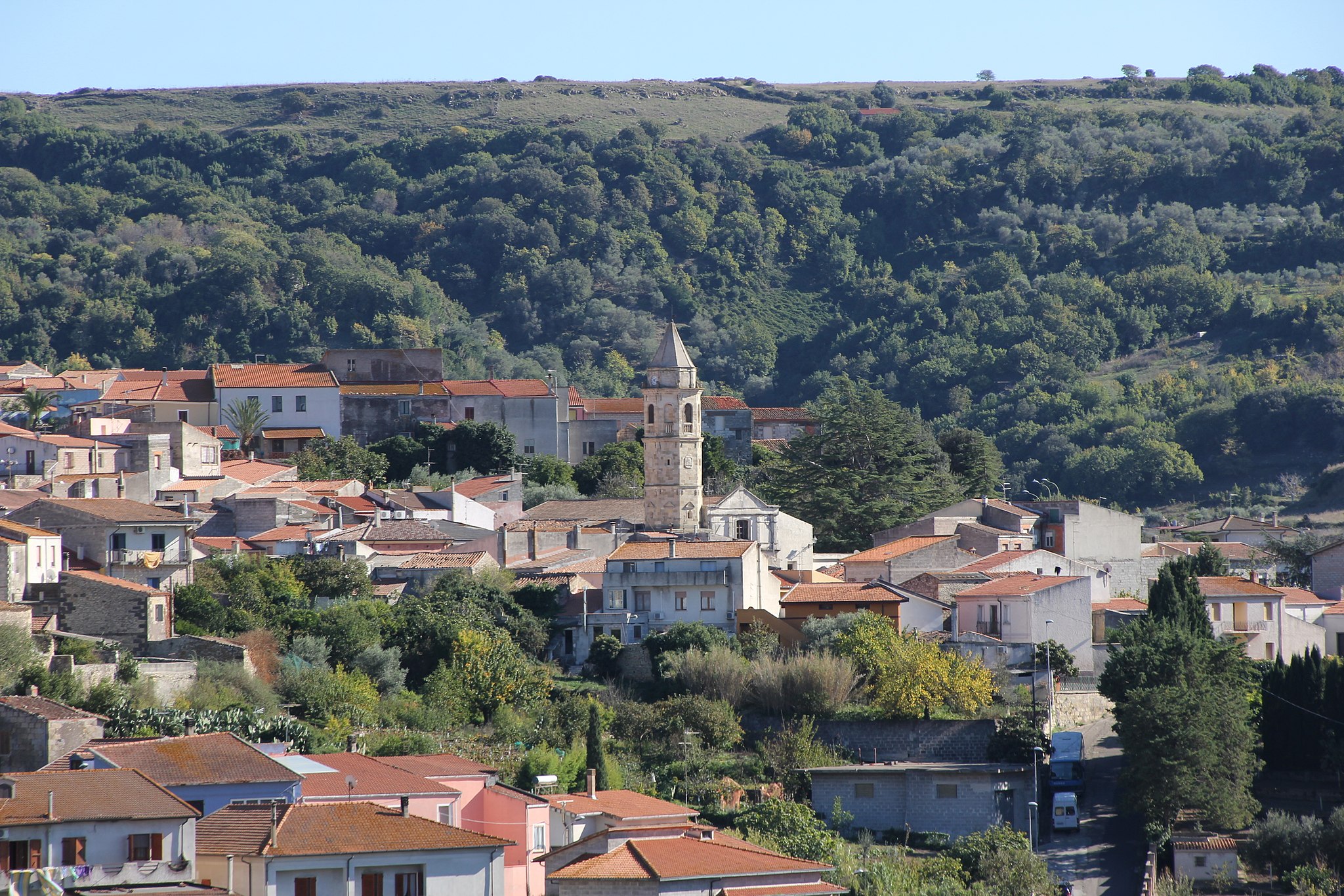
Ussassai
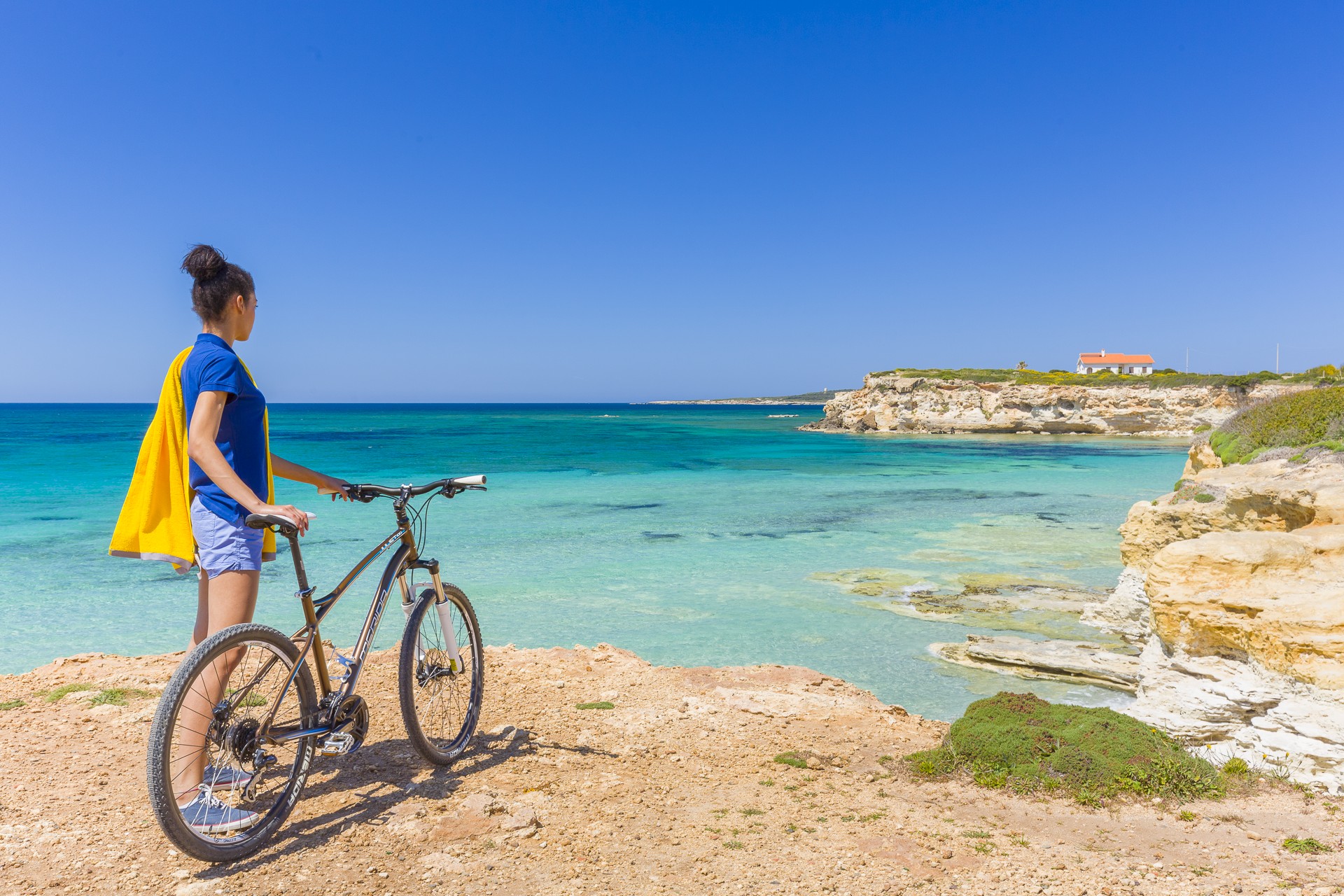
The town sits perched at over 700 metres on the north-eastern slopes of Monte Arcuerì, overlooking the San Gerolamo river valley below, protected by limestone-dolomite bastions and deep gorges covered in woods. With less than 600 inhabitants, Ussassai is the smallest of the towns of the Barbagia di Seulo, as well as being its easternmost, not far from Ogliastra along state motorway 198, the road that connects Seui and Lanusei. The views from town are breathtaking: around the shimmering walls outcrops of rock have been sculpted by the passage of time, erosion, and some now resemble known personages, like the one they call Dante because it looks like the poet’s profile. The limestone stacks effectively isolated the area for centuries and thus also preserved its pristine beauty. There is a myriad of streams, oak and cork trees and Mediterranean shrubbery in which to go hiking and biking, especially in the Takiggeddu, su Piss’e Irtzioni and Niala woods.
A part of Montarbu (most of which is under the jurisdiction of Seui) falls under Ussassai, an area of pristine nature, home to one of Sardinia’s loveliest forests, a fauna oasis since 1980, where deer and mountain goats roam, the hunting grounds of royal eagles and peregrine falcons. You can also go visit the lovely landscape of bare peaks and verdant nature in something of an alternative way: on board a Trenino Verde (Green Train), whose Mandas-Arbatax line stops at the old Ussassai station that was inaugurated in 1893, today used exclusively for tourist services.
The town’s origins date back to time immemorial and it is steeped in rural tradition. The lower part stands out for the old stone houses while the upper part of town boats modern dwellings. The main church, which is home to a precious ostensory dating to 1625, is dedicated to San Giovanni Battista, celebrated in late August. A week earlier – on 10 August – they celebrate San Lorenzo. Ussassai is famous for its red apples, the stars of festivities at the end of October when locals make such delicacies as culurgiones cun sa mècuda e is coccois prenas. Another important date is the Coja antiga in the second half of August, with a heartfelt traditional re-enactment of rural wedding. At santu Gironi, in the countryside not far from the town, is the sanctuary of San Salvatore. The Romanesque-Byzantine building dates to the XII century and houses stone trunks placed in a semicircle, the famous cumbessias, or accommodations, for the faithful who flock here to celebrate San Salvatore and San Gerolamo (12 and 30 September respectively). The church may have been the parish church of the old town of Trobigitei, which was abandoned and disappeared under Aragonese rule.

Capo Pecora
An unspoilt, picturesque place, far away from everything. Capo Pecora is one of the gems of the Costa Verde and is on its southernmost extremity, in the territory of Arbus. To the south, it is on the border of Portixeddu (Fluminimaggiore) and to the north it borders on another pearl of Arbus, Scivu. Its granite promontory stands out along a coastline dominated by limestone rock: the pink granite contrasts with the turquoise sea and the green Mediterranean scrub.
Sheer, windswept cliffs, overlooking the sea, outline it and frame the little beaches with pebbles smoothed by the relentless work of the sea. In the little coves, the rocks have taken on unusual guises: one of them is known as 'beach of the dinosaur eggs'. The biggest beach in Capo Pecora, surrounded by fragrant shrubs, has large-grained golden sand. The waters are particularly transparent and take on a bright sapphire blue colour - a true delight for the eyes.
The locality is quite sparsely frequented and is a silent, private oasis. It is known for its marine wildlife and the seabed is teeming with gilthead bream, flathead grey mullet, sea bream, octopus, amberjacks, sea bream and sea bass. Therefore, it is very popular with snorkelling enthusiasts: don't forget your mask and camera if you want to discover and immortalize the beauty around you and the wonders of the seabed.
With a long but not challenging trek through the cliffs and granite walls, from the promontory of Capo Pecora, inhabited since prehistoric times and perfect for palaeontology and fossil enthusiasts, you will reach the beach of Scivu, where you can visit its nature reserve. The trail, high up above the sea, unwinds along paths and mule tracks. Once you have reached the highest point of the plateau, at the watchtower, you can look out to the north at the spectacular view of the Costa Verde: the 'desert' of the wild and wonderful Piscinas and the other 'pearl' of Torre dei Corsari. Then you can go down the steep slopes to reach Scivu, where you can hear the sound of the fine-grained sand as you walk on it. The coast of Arbus is a long series of immense beaches with sand dunes that plunge into the waters tinged with blue and emerald green. It also includes Portu Maga, the Marina of Arbus and Funtanazza, captivating places and surfers' havens.
S'Arena Scoada
Slightly south of Capo Mannu, in the northernmost point of the Sinis peninsula marine area, in a setting of astonishing coastal beauty that alternates small coves and stretches of limestone rock, there is a long beach with an oceanic-tropical appearance. This is S'Arena Scoada, which extends from Punta S'Incodina, near the cliffs of Su Tingiosu, as far as Putzu Idu, from which it is separated by a small reef. The beach is part of the San Vero Milis territory, less than twenty kilometres away (while Oristano is 25 kilometres away), and it was originally known as S’Aena Scoada, meaning the donkey without a tail. The name was later transformed into 'sand without a tail', a type of very fine, golden sand alternated with tiny fragments of multi-coloured quartz, stones and smooth rocks. One of its distinguishing features is the limestone rocks mixed with clay, used for sand-baths. The water is very clear and it is a green-blue colour, while the sandy seabed slopes gently. From here, you can admire landscapes that open up towards the island of Mal di Ventre. The sandy shore is very popular with kitesurfing and windsurfing enthusiasts and it has ample parking and a bar.
Behind it, lies a small tourist centre, while to the north you can admire a fascinating arch dug out of the rock: S'Architteddu. Further on, there is the beach of Putzu Idu and other gems including Capo Mannu, an immense promontory that is almost an island, given that it is connected to the mainland by strips of land and by the Salina Manna pond. In order of appearance, first of all you will encounter Mandriola, followed by the coves of Sa Figu and Dei Tedeschi, Sa Mesa Longa, Su Pallosu and, after going beyond the promontory, there is Sa Rocca Tunda and then the little coves of Scal'e Sali. To the south, on the border of Riola Sardo, the rocky coast rises with respect to the water's edge, almost announcing the impressive sight of the cliff of Su Tingiosu. Erosion of the limestone has led to the creation of enchanting little coves.

Casa Steri - Museum of Sardinian Farming and Food Culture
One of the most distinctive aspects of Sardinian cultural traditions is food, narrated in its evolution over thousands of years: not only foods, but also the cultivation, preservation, transformation and production techniques. All this inside a seventeenth-century Campidano manor house ‘with a courtyard’: it is Casa Steri, in the historic centre of Siddi, a rural village ‘lying’ at the foot of the giara of the same name. The theme of the museum exhibition is the history of the Island’s food since the Nuragic age and it is divided into various spaces, residential and productive. You will visit rooms dedicated to the production cycle of milk and oil. It is no coincidence that Siddi is part of the Italian ‘Città dell’Olio’ (Cities of Oil) circuit. You can also admire a grain mill with a rare eighteenth-century millstone powered by horses. In the kitchen, you will see traditional objects such as sieves, baskets and clay scivedde (containers).
You can also visit rooms used as shelters for work and farmyard animals, among which stables, where tools for branding livestock and wine-making equipment are on display. There is also a granary, with various tools needed for working in the fields: ploughs, hoes, sickles and seeders. In the various rooms, there are panels with texts describing traditional farming activities, which the inhabitants of the village helped write, as a ‘historical memory’ and source of knowledge handed down by the community. Events and temporary exhibitions are often held in the ‘reception room’ of the house, in which the walls are painted with Art Nouveau motifs. Workshops are also periodically organised in the museum, during which you can learn techniques for making products like pasta, bread and desserts and learn about the characteristics and curiosities of the products of Sardinian cuisine.
The Siddi territory combines captivating natural environments with an important archaeological patrimony: the two aspects coexist in the park of sa Fogaia, a kilometre and a half from the town. In a forest of holm oaks and Mediterranean scrub there are numerous plant species, aromatic plants and flowers, together with about 60 bird species – which you can learn more about at the Ornithological Museum of Sardinia, the only one of its kind on the Island –, without forgetting reptiles, hares and foxes. In the upper part of the park, you’ll find the nuraghe sa Fogaia, with a more ancient core and buildings added later on. A few kilometres further north, on the Giara di Siddi, one of the most famous and best-preserved Giants’ Tombs awaits you: sa Dom’e s’Orku. It is a megalithic tomb dating back to the Bronze Age and was made with large blocks of basalt from the same giara, set in a splendid landscape.

Porto Faro
A jewel nestled in the heart of Palau, a short distance from the inhabited town of Porto Faro is one of the most characteristic beaches of northern Sardinia, the name of which derives from a white lighthouse whose painted tip overlooks a small inlet carved into the locality of Punta Palau. From here, you can savour the panorama of the entire national park of the archipelago, from the “big sister” of La Maddalena to the smaller islands of Santo Stefano and Caprera.
Within the cove is a picturesque beach, characterised by fine white sand, lapped by the crystal-clear sea with a shallow and sandy seabed. Strolling along the cove or snorkelling, you will be fascinated by the sight of pink granite rocks eroded by the waters to take on quite unique forms. Not surprisingly, just a short distance away is the monument that most characterises Palau, the Roccia dell’Orso.
Porto Faro is surrounded by Mediterranean scrub that extends almost to the sea. It is not particularly crowded even in summer, being the ideal place for those who love tranquillity and relaxation. Within walking distance, you will find all the tourist services you could need. Behind the lighthouse is a tourist village perfectly inserted into the dense vegetation and bathing facilities available. Nearby, there is also a little private pier suitable for mooring small- and medium-sized boats so you can set out on an exploration of the Maddalena archipelago.
Mara
The village is perched on a plateau, surrounded by hills and valleys covered in Mediterranean brush. Mara is a small village in the Meilogu area with a population of around 600, whose name means "marsh". The villagers' traditional occupation is sheep-farming, as you can discover from the Centro di documentazione della civiltà contadina (Farming civilisation records centre), part of the Grazia Deledda literary park. At the centre of the village stands the 18th century parish church of San Giovanni Battista, a harmonious blend of styles with its Gothic-Aragonese belltower and Baroque facade. The church has multi-coloured wooden altars, a large 17th century altarpiece, and 18th century statues and paintings. In the old town ("Mara antica") is the church of Santa Croce (17th century) with a nave divided into two cross-vaulted bays and a "Renaissance" doorway in limestone.
The land around Mara is dominated to the north by Mount Traesu, one of the volcanic craters of the Meilogu region, and a peak topped by the ruins of Bonuighinu castle. The fortress, possibly built by the Doria family, passed to Arborea and later to the Aragonese. You can still see the remains of the walls, tower and two cisterns. Between these two bare peaks, a smaller hill is home to Nostra Signora di Bonuighinu, a 17th century extension of a pre-existing building, which may have been the parish church of a subsequently abandoned medieval village (documented in the condaghe di San Pietro di Silki). Legend tells that the Madonna appeared to invite the inhabitants of Mara and the nearby villages, who were in conflict, to establish rules of bonu ighinau (neighbourliness). The sanctuary was built on the spot where she appeared. Restored in 1797, the complex includes a church, cumbessias, loggias and "palazzotti", which are used during the festival of the Madonna di Bonuighinu in late September. The ornate facade, preceded by a stairway and sacristy, is in Rococo style. The sobre interior hosts three Baroque wooden altars. A mule track leads from the church past the opening of the sa Ucca de su Tintirriolu (the bat's mouth) and sa Ucca de Filiestru caves, which were constantly inhabited from the 6th millennium BC to the late Bronze Age (11th century BC). The prehistorical culture of Bonu Ighinu (4th millennium BC) was named after the caves, thanks to their archaeological significance. The remains from the various "cultural" layers (held in the G.A. Sanna Museum in Sassari) show that the people living there were farmers and hunters. The first cave is at the foot of a limestone cliff: smaller tunnels, passages, rooms and drops lead off a main tunnel with ceilings up to 20-25 metres high, amidst stalactites and stalagmites. A torrent runs underneath all year round. The inhabited part was closest to the entrance, while the remains found in deeper areas - small idols and carvings on vases - suggest a place of worship, also used by the inhabitants of the more cramped Ucca de Filiestru caves. Mara has a high number of nuraghes (17), some of which are well-preserved, including the Tomasu nuraghe, originally single-tower, with a second tower added later, with a surrounding village, the Coladolzos "corridor" nuraghe and the settlement of sa Mura.
Notteri - Timi ama
The Notteri beach is a carpet of sugar-fine white sand, lapped by a crystal-clear sea. That is why it is often picked as a set for films and TV commercials. Its pristine natural environment is enhanced by the nearby Notteri marsh, home to the stately pink flamingos.
The beach is easily reached following the road signs to Villasimius, along Provincial Road SP 17. Once in town, drive along the main road heading south, and follow the signs to Notteri.
In addition to its natural attractions, the beach has a number of services: it has a spacious parking area also suitable for campervans, a hotel, bars, a restaurant and night clubs. It is also accessible by persons with reduced mobility. Its gently sloping seabed makes it safe for children. Rental of sun umbrellas, beach loungers and pedalos. Its good exposure to the wind makes it much loved by windsurfers. It is also a favourite destination for breath-hold spear fishermen and scuba divers.
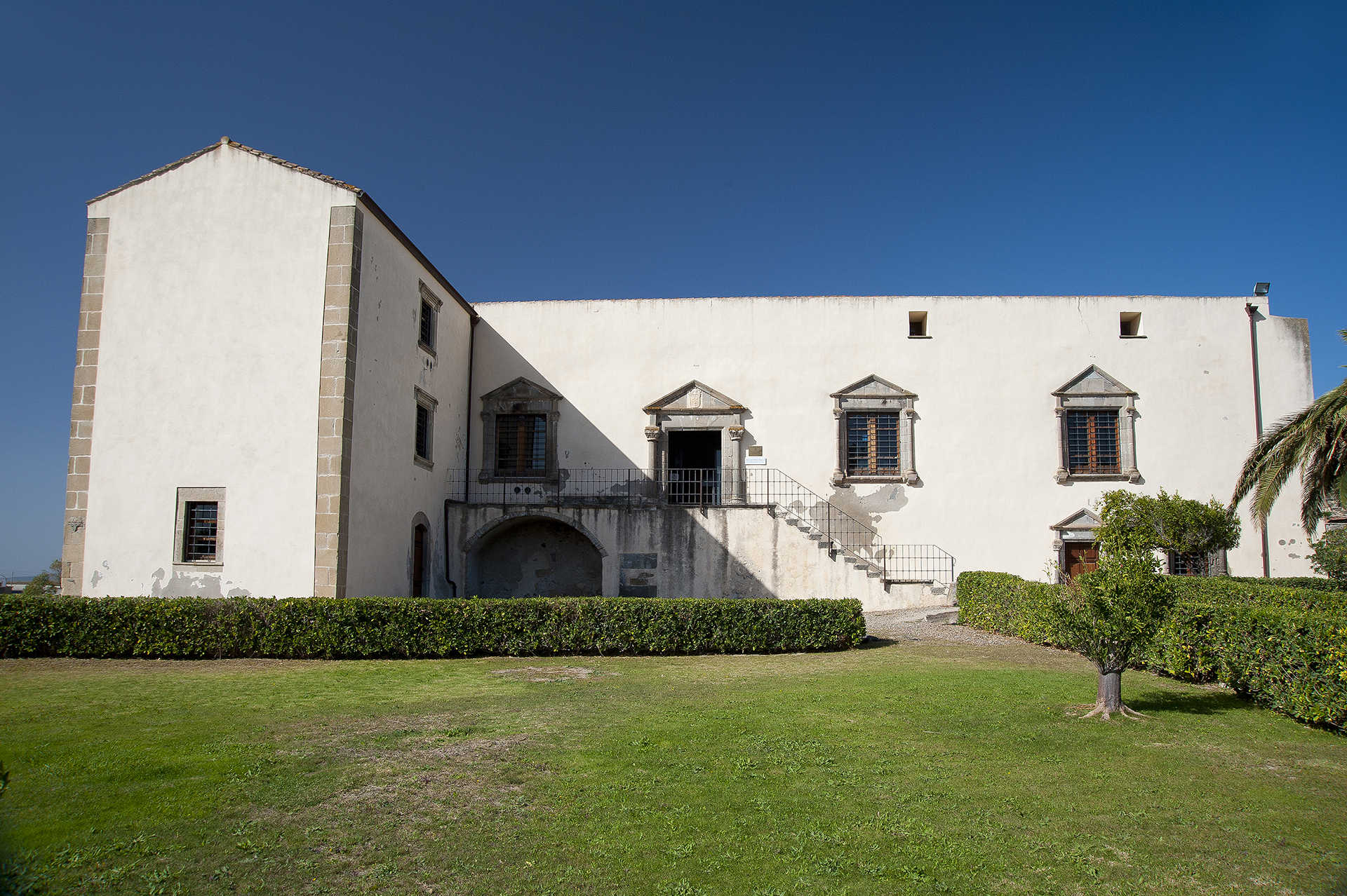
Casa Zapata
Noble power, good taste and a display of luxury combined with a priceless cultural patrimony. In Barumini the beautiful dwelling of the Zapata family, the building of which was ordered by Don Azor, alcalde of Cagliari, at the end of the 16th century, over the ruins of a nuraghe. Since 2006, the Spanish residence has been a museum centre. The building is a rare example of Hispanic civil architecture in Sardinia, built based on classical-style models. You will see this clearly in the features of the residence, divided into two floors, and in the architectural decoration.
The façade has a portal and windows with tympana resting on smooth columns with a double torus base, grooved door-jamb and coffered capitals. The family crest is carved into the central tympanum: a vermilion shield with three gold-checked shoes. The same elegance can also be seen in the staircase. You will recognize the buyers’ classical taste in the Zapata family palace in the Castello district of Cagliari.
In 1990, the 'musealization' of the house began, in order to enhance the value of the findings from the nearby Nuraxi, the greatest piece of evidence that we have inherited from the Nuragic civilization. It was found that it had been built over another complex nuraghe, renamed Nuraxi e' Cresia because of its proximity to the parish church, frequented between the 14th and 10th century BC. The excavations safeguarded the structure of the house and, at the same time, made the view of the complex visible from above, with suspended walkways and transparent floors: you will enter a noble palace and suddenly find yourself above a nuraghe. Inside Casa Zapata two towers are visible (central and eastern), while the other two, the double defence wall and the village are outside the palace.
The nuraghe is part of the archaeological section of the museum, along with a collection of over 180 artefacts found at Su Nuraxi, among which a famous model of a nuraghe made of limestone. Another two sections are set up in the ancient rustic courtyard adjoining the palace. In the historical-archival showcases, you will see thousands of documents - original papers and digitized documents - that tell the story of the Zapata family from 1541, when Azor acquired the fief of Barumini, Las Plassas and Villanovaforru. The ethnographical section hosts tools for daily and agricultural activities dating back to the early 20th century. Here, the regional museum of the Launeddas is located. These are ancient, traditional Sardinian musical instruments with three pipes.

Funtanazza
A suggestive stretch of coast where the golden colours of the sand, brown of the rocks and blue of the sea blend, in a scenario that for almost three decades, between 1956 and 1983, has been a 'summer colony' for many children. Funtanazza, set among the stupendous Torre dei Corsari and Marina di Arbus, was the first and pioneering resort in the uncontaminated and wild (then more than ever) Costa Verde, in the territory of Arbus. From June to September the children of the miners of Ingurtosu and Montevecchio, about twenty kilometres away, spent their holidays in the 'Francesco Sartori' seaside colony, built by the company that managed the mining sites - as wished by CEO Rolandi - "as the reward of so many labours, so many sacrifices, so much darkness accumulated in the tunnels". You can reach it by taking the state road 126 through a world crystallized in time, made of abandoned mines and ghost villages. The nearest services are in Marina di Arbus, Torre dei Corsari and in the tourist village of Portu Maga.
The inlet of Funtanazza welcomes, partly sheltering it from the mistral, a stretch - about one kilometre - of medium-grained golden sand, bathed by the limpid sea with its colours shifting between green and blue, with a sandy bottom dotted with a few rocks, which gets deep very quickly. The beach is bordered by cliffs covered with thick Mediterranean vegetation: on one side large basalt rocks hide small caves, while on the other the cliff slopes gently. To the south, down to sa Cabada bianca point you will be able to pick your way between volcanic rocks containing an infinity of fossils easily visible on the white cliff, dating back to the Miocene. The complex, impressive in size, overlooks the beach. A verdant pine forest of nearly eight hectares overlooks the coast, along with the imposing complex of the former colony, which occupies more than two thousand square metres and could accommodate about two hundred children and sixty adults. Consisting of three distinct areas, including accommodation facilities and two swimming pools, it was autonomous thanks to the aqueduct, electric cabin, radio link and telephone systems, as well as access roads. When built (1956) it was considered a futuristic structure, the most modern in Europe. Today it is a huge and spooky building awaiting redevelopment.
South of Funtanazza you will discover the two most splendid pearls of the Costa Verde: Piscinas, a sandy desert lapped by the emerald sea, and the 'talking' beach of Scivu. Other spectacular dunes on the north end of the coast are the Sabbie d'Oro of Pistis.

Suni
It sits on the basaltic plateau of Planargia, overlooking the valley of Modolo. Suni is a town of just over 1000 inhabitants a few minutes from Bosa, with which it participates in Strade della Malvasia event: where visitors can taste this prized sweet wine. In the Medieval period, the town was first part of the Giudicato of Torres then, following a brief spell under Malaspina family control, it passed to the Giudicato of Arborea. The town extends around the Church of San Pancrazio (15th century) and the Parish of Santa Maria della Neve. Saint Pancrazio’s Feast Day is celebrated in mid-May with processions, traditional song and dance, and an ardia. Saint Mary’s Feast Day, on the other hand, is celebrated in early August with a Folklore Festival. In late June, there is the Festival of Saint Narcissus, in the charming country church dedicated to him. In late September, saints Cosma and Damiano are celebrated.
Near the parish, in the town centre, a residence that has retained its original architecture has been transformed into the House Museum of Tiu Virgiliu, a ‘living’ example of 19th and 20th century popular culture. It contains over a thousand objects, artefacts and machines used by craftsmen and farmers in displays including a cobbler’s workshop and a weaving corner. A photographic exhibition talks about Suni’s Pre-Nuragic and Nuragic sites. Periodic exhibitions focused on cereal processing and bread making, traditional dress and toys also take place.
According to legend, Suni is the modern Sa Idda Ezza (the old town), where Nuragic ruins including the Giant’s Tomb of Chighentolu were unearthed. The village is found near a 12th century Cistercense monastery. In reality, the area around the town bears signs of even older human settlements, dating to the Neolithic. The most important prehistoric sites can be found in the Suni Archaeological Park, which includes the Seneghe Proto-Nuraghe, the Nuraddeo Nuraghe complex and the Domus de Janas of Chirisconsis. Seneghe is a rare example of an accessible corridor nuraghe: dating to the Copper Age (2400-1800 BC), it is set on a basaltic cliff. A variety of Roman pottery has been found around the site. Nuraddeo is composed of a well-preserved 16-metre-tall keep surrounded by a three-towered bulwark. The remains of a village can be seen around the site. The hypogenic necropolis of Chirisconis, carved into the tuff, consists of 12 openings leading to single and multiple chamber burials: in all, it contains 21 small chambers with traces of red paint on the walls and access to a ‘vestibule’. Near the park, gleams the Pischina ‘e Paule pond, inhabited by numerous animal species. From here, you can set off on scenic walks through griffon nesting areas.