
Gonnosnò
It is located at about 200 metres above sea level at the food of the Giara plateau, within a naturalistic context of great environmental value. In the upper Marmilla, today it boasts around 800 inhabitants. As the toponym (gonnos, high ground) indicates, Gonnosnò, is at the centre of a hilly area that also includes the fraction of Figu, so called presumably due to the abundance of fig trees. In 1947, the municipality was named Figu-Gonnosnò, assuming its current name as of 1964. The town and township are mentioned in the books of Sardinian history due to being the first to have established a Monte Granatico (1678). It is not by chance that the economy is agricultural-pastoral, even if craft plays an important role.
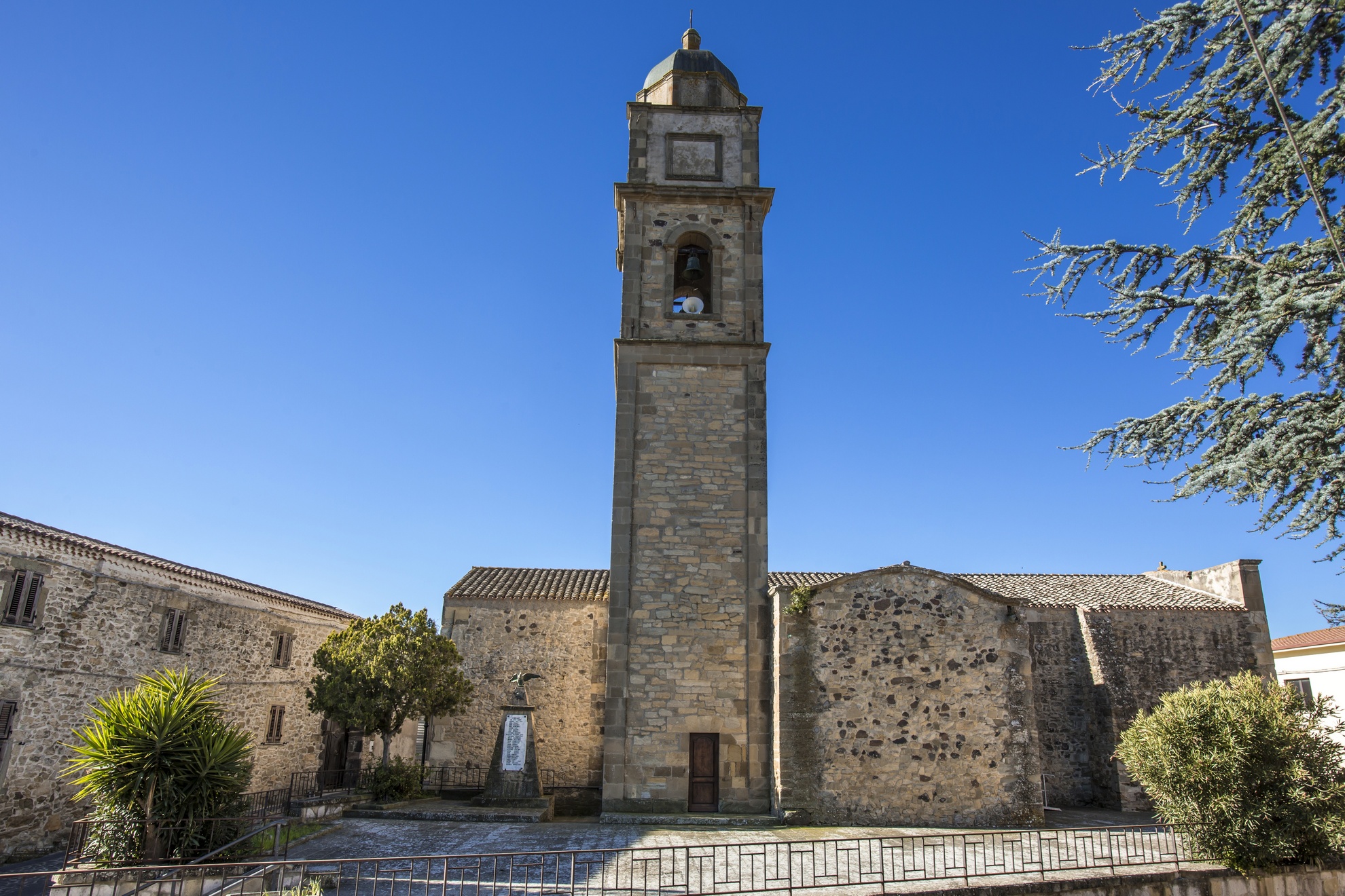
Amongst the artistic excellences of the village is the parish church of Sant’Elena Imperatrice, with a bell tower dating back to 1645, topped with a small dome. Until the 1970s, it was also covered with 800 coloured tiles (since removed). Inside are two chapels dating back to 1690: the Madonna del Rosario and San Basilio, in which there is a wooden altar embellished with carvings and gildings. The baptismal font is from the 17th century whilst the main altar is from the 19th century, with a polychrome marble antependium from the 1700s. The patron saint is celebrated in mid-August. Perched at the top of a hill since 1624, the Chiesa di Figu is dedicated to the Nativity of the Virgin Mary. The main door is adorned with a contoured and decorated architrave. The interior has a single nave with a wooden roof. It houses three very ancient statues: the Resurrection, Virgin of the Rosary and Sant’Antonio Abate, in whose honour bonfires are lit in mid-January. The other celebrations are held for San Sebastiano (20th January), San Salvatore (the first Tuesday after Easter), San Bernardino da Siena and San Priamo (mid- and late-May) and San Vitalia (early October).
The territory of Gonnosnò is rich in Nuragic remains: the temple-well of San Salvatore, constructed in worked stone blocks at about 300 metres from the spring, the four Tombs of Giants of Is Lapideddas and a dozen single-tower Nuragic structures scattered throughout the territory. The most interesting is the Nuraghe Nieddiu on a protruding spur of the Giara, perhaps an imposing defensive structure, made of roughly-shaped basal blocks that have been carefully positioned. The tower has a diameter of 11 metres and is currently three metres high.
Magomadas
Magomadas is one of the Borghi Autentici d’Italia (authentic villages of Italy) and is included amongst the Città del Vino (cities of wine), which is not surprising given that it is part of the ‘Strada della Malvasia di Bosa’ (Malvasia di Bosa road). Magomadas is a small town with less than 700 inhabitants of Planargia sub region that unfurls along the top of a hill with a panoramic view of the Modolo valley on one side, and the sea with kilometres of evocative coastline on the other. The picturesque village is characterised by ancient houses and surrounded by the warm colours of the vineyards that extend along the fertile countryside that has always marked the agricultural-pastoral traditions and economy of the community. As proof of this, in a 16th-century building in the historical town centre, there is the Museo del Vino (wine museum), providing a historical excursus on winemaking in Planargia, and a wine shop with wine tastings paired with typical dishes. Also in the town is the parish church of San Giovanni Battista, built in the early-17th century in late Gothic-Catalan style (subsequently restored). The single nave is interrupted by a triumphal pointed arch in red trachyte that leads into the presbytery. Of particular value therein are three 18th-century altars. Also worth a visit is the Chiesa di Santa Croce, dating back to late-14th/early-15th century, housing a beautiful wooden Christ with outstretched arms, the protagonist of the Rito de s’Iscravamentu during Holy Week.
Amongst its attractions, the small town also boasts a stretch of coast with beautiful white beaches, rugged cliffs and pristine waters of deep blue. In the hamlet of Santa Maria del Mare, three kilometres from the village, is the church of the same name that dates back to 1635. Once known as s’Stella, two celebrations take place here in the third week of May and in August - a procession and concerts in the piazza - being the most adored by the Magomadese community and with many visitors in attendance thanks to the Sagra della Malvisia (malvasia festival) also taking place.
The territory has been inhabited since the Nuraghic age, as evidenced by the remains of a sacred well in the locality of Puttu and various Nuraghic structures, with the Nuraghe Sebe on the outskirts of the town ‘strategically’ dominating the surrounding valley. The original settlement was built during the Punic period, as can be determined by the toponym magom adasht or, ‘new city’. The ancient Carthaginian settlement near the sea transferred to a hill near the current ruins of the Chiesa di San Nicola for means of defending the people against Saracen raids in the 14th century. Around 1388, the village was the heart of the island, where the peace treaty between Eleonora d’Arborea and the King of Aragon was stipulated.

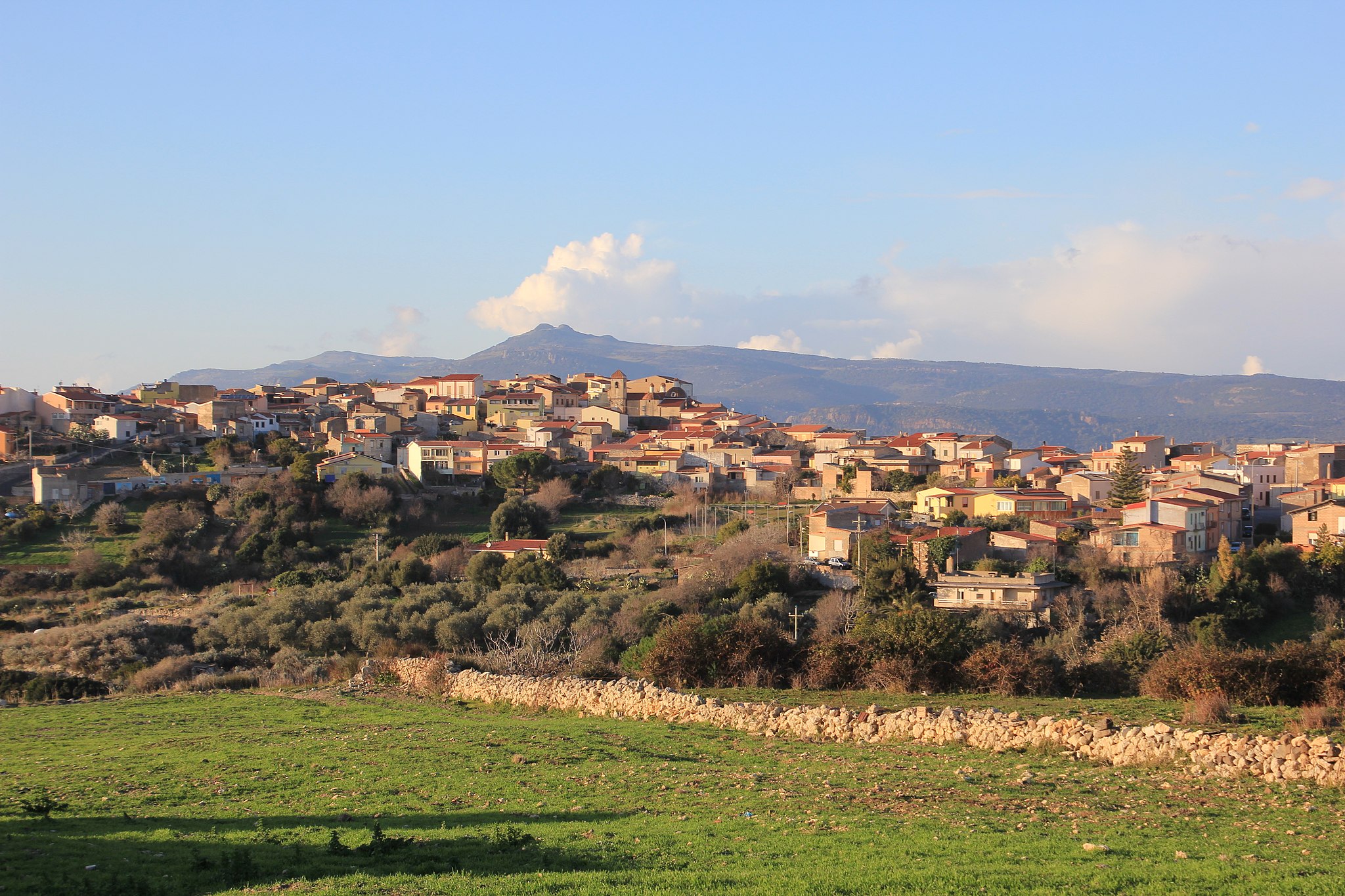
Mogorella
It rises at the base of the evocative Mount Grighine in a luxuriant area dominated by the Monte Arci park and covered with Maquis shrubland (cistus, strawberry trees, holm oaks, lentisk, myrtle), downy oaks and cork oaks, being the habitat of numerous animal species. Mogorella is a very small town of about 450 inhabitants in the upper Marmilla region, in the province of Oristano. Its toponym, officially certified in 1546, indicates a ‘small hill’. The patron saint of the village is San Lorenzo, celebrated twice a year. Firstly comes a procession on 20th May accompanied by folk groups and knights, in conjunction with the Sagra della Pecora (sheep festival), with the traditional dishes enjoyed together with local wine; and then in mid-August there are religious rituals and civic events.
Its territory has been inhabited since prehistoric times, as can be proven by seven Nuragic remnants, the great attraction of the area. Of particular importance is the Protonuraghe Friarosu, which stands on a 400-metre-high limestone plateau near the entrance to the village. It has a ‘corridor’ structure, of which seven stone rows remain, with a height of five metres. This represents, especially in the architectural context of the two internal sub-elliptical spaces, the ‘connecting link’ between the archaic Nuragic typology and the more evolved tholos (false dome) variety. It dates back to between ancient and middle Bronze period, as confirmed by the numerous ceramic finds discovered, including plates, pots, bowls with rims, hemispherical and streamlined bowls, narrow-mouthed ollas, all materials from the Bonnanaro culture, used both in Proto-nuragic and in the Nuraghe a Tholos. Another important prehistoric remnant is the Nuraghe Mannu, being the best preserved of all. Neighbouring these are the Nuraghi Bau Tentu, consisting of two circular structures joined by corridors, and the Luas, originally consisting of three overlapping rooms connected by a staircase. Of the Nuraghe Cuccuru, one kilometre from the inhabited town centre, there remains a tract of the perimeter walls. The Aresti, Pastoris and Ruina Tassa are of single-tower type, just like the Nuraghe Fenugu, around which a large village presumably stood. The discovery of a precious and rare bronze sculpture, the Gladiator of Mogorella, today displayed in the National Archaeological Museum of Cagliari, proves that the area was occupied in Roman times. At almost eight centimetres, the statuette depicts a secutor, who was opposed to the Reziario and had to dodge fearful weapons. The head is covered by a helmet, whilst the raised right hand holds a sword (of which remains the hilt), and the left one a shield, now lost.

Furtei
Furtei stretches along the western side of a hill between Medio Campidano and Marmilla. A small town with 1,600 inhabitants, it lies around 40 kilometres from Cagliari and has an economy based on agricultural activities. It was an important town during Medieval times. The territory includes a high concentration of Nuragic remnants, with the ruins of five Nuraghe structures. A short distance from the town is the village of Nuraxi, documented since the 17th century. Now almost entirely uninhabited, here once stood the ancient parish church, the town church of San Biagio, dating back to the 13th century. A tradition event taking place on Palm Sunday sees the mayor deliver La Palma della Passione to the parish priest, who carries it in a procession. This ritual is a symbolic act in memory of the peace established between Furtei and Nuraxi (1605) through the intercession of Baron Santjust, who gave a palm branch to the families in each of the two villages.
Today, the parish church is the Chiesa di Santa Barbara, with the saint’s feast day celebrated at the beginning of December. Inside there is a painting depicting the Crucifixion of Jesus, an act that is ‘relived’ during Holy Week, on the Friday prior to Easter. The parish church, former parish church and churches of Santa Maria della Natività, of San Narciso (from the 13th century), of San Sebastiano and of the Sacra Famiglia come to life on the occasion of the sacred rituals, from the Friday of the Passion prior to Palm Sunday, with Sa Pintadura De Sa Prama, through to the Easter ritual De Su Incontru, followed by the processions of Our Lady of Sorrows and Palms, for the preparation of Christ and for Su Scravamentu (the deposition of the body of Christ). In addition to these holy events, there are also many religious festivals, including the bonfires of San Sebastiano (19th January), the celebrations of Sant’Isidoro, protector of farmers (mid-May), of San Biagio at the end of August, with the evocative procession of the return of the saint, and of San Narciso (end of October), with the intonation of the rosary with alternating choirs and the invocation of Is Coggius, all in the Sardinian Campidanese dialect. The main festival is held in the second week of September for the birth of the Virgin.
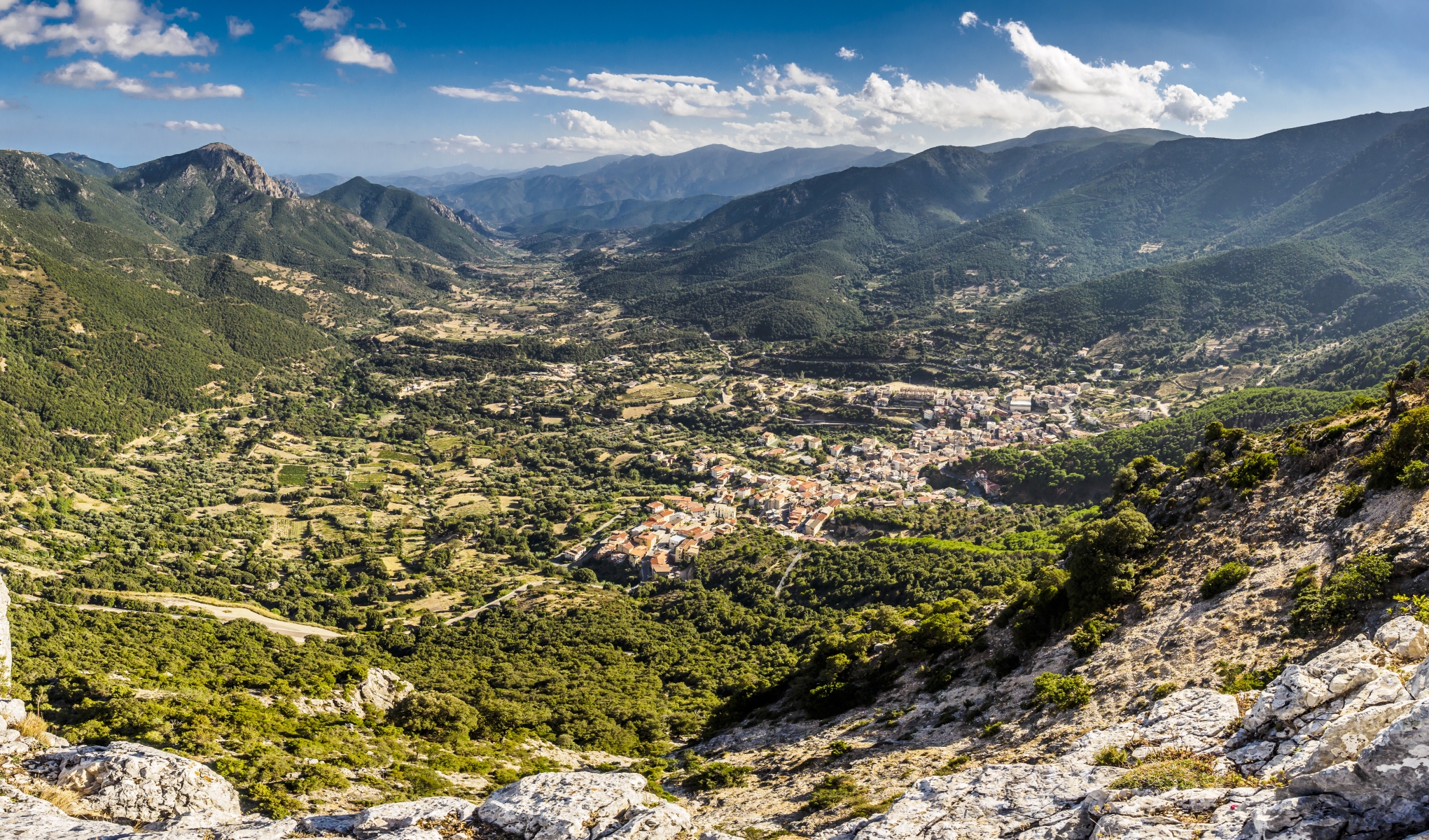
Urzulei
Urzulei extends up the slopes of the imposing Monte Gruttas, surrounded by the impervious and wild landscapes of the Supramonte, reaching heights of a thousand metres and replete with ravines, sheer cliffs, chasms, dolines and gullies right up to the sea. A town of 1,300 inhabitants to the north of Ogliastra, Urzulei borders the Barbagie mountain area of inner Sardinia and is dedicated to animal farming, resulting in exquisite delicacies: hams and Guanciale (cured meat from pork or wild boar jowl or cheek) and cheese, including casu marciu, sa frue and caglio di capretto.
On the border with Orgosolo, the deep su Gorropu gorge is truly impressive. At 500 metres in length and 1.5 kilometres wide, it is one of the largest and most spectacular canyons in Europe, modelled over the millennia by the Flumineddu, one of the two major waterways in the area, together with the Codula di Luna, which flows gently to the Gulf of Orosei. Thousand-year-old junipers and yew, holm-oak forests such as su Fennau, and Mediterranean essences fill the valleys, coloured in spring by orchids, peonies, and oleanders. It is the habitat of the mouflon and the golden eagle. In the oasis of sa Portiscra, the Sardinian deer can also be glimpsed.
For centuries, access was limit to Roman rulers, with a third of the territories composed of carbonate rocks pierced by about 200 caves. Standing out are those of su Palu, 15 kilometres of tunnels and rooms similar to fairy-tale worlds, of s'Edera, in which three rivers flow, uniting in a re-emerging torrent in the su Gologone spring; and of su Eni de Istettai, which reaches the heart of the Supramonte, a destination point for speleologists from all over the world. The impervious elevations were largely inhabited during the Nuragic age. The two monumental Tombs of Giants of s’Arena bear witness to this, part of the complex including the Nuraghe Perdeballa, the village Or Murales, one of the largest on the island and bearing over 100 huts, and the hypogeic sanctuary sa Domu ‘e s’Orcu, a grotto overlooking the town, where the statue ‘Mother With Her Dead Son’ was found, a famous bronze exhibited at the National Archaeological Museum of Cagliari. Grottos and sites on the Cammino di San Giorgio can be visited, a pass from which the s’Iscala de su Piscau can also be admired.
The village is embellished with ancient buildings of worship: the 16th-century Chiesa di San Giorgio in Gothic-Aragonese style, the parish church of San Giovanni Battista (17th century) which contains a pink marble altar and a prestigious baptistery, and the quaint church of Sant’Antonio da Padova. The patron saint is celebrated twice - once on 26th April and again at the end of August, when the Palio di Urzulei is held. San Giovanni is celebrated on 24th June. Celebrated a week prior, festivities are held in the small church of San Basilio Magno of the medieval village of Mannorri, having disappeared at the end of the 18th century due to a mysterious series of events that involved feuds and balentia (courage), love and betrayal. Echoes of the past can be found in the music, dance, poetic competitions and in the small houses of the Museo Andalas de Memory. Echoes of the Dionysus worship rituals can be found in the carnival mask of su Mamuthoì’e Bruvera, also called s’Urcu. Every August, the town comes to life for the morra tournament, in which contenders from all over Europe participate. The cuisine is traditional: macarrones imboddiaos, culurgiones, roast suckling pig and kid, lamb cooked in the pan and the sheep dish, ‘Pecora in Cappotto’, venison cacciatore or flavoured with myrtle. All is accompanied by the cannonau wine. Su piggiolu is the bread par excellence.

Santa Giusta - Castiadas
To the north, the last beach of Castiadas is part of the Costa Rei coastline, confirming all of the area’s most charming characteristics, with a few extra distinctive traits. Santa Giusta consists of a beach about a kilometre long, also known as the beach of Villa Rei, and by a decidedly smaller cove, framed on one side by a small promontory and on the other by a white granitic outcrop known as the Scoglio di Peppino (Peppino’s Rock), with a shape resembling a tortoise. The ‘rock’ marks the border between the coastal territory of Castiadas and that of Muravera and it is one of the main attractions of the Costa Rei. You can lie on its ‘back’ to sunbathe, stop to take some striking photos and practice a few dives.
The sand of Santa Giusta is soft and white, almost impalpable, with golden reflections and a few grains of shingle. The crystal clear sea will enchant you with its turquoise colour and hints of emerald green, thanks to the sunlight as it reflects on the surrounding vegetation. The waters are shallow and get deeper gradually, making the beach safe for children and allowing the water to warm up quickly, resulting in a ‘swimming pool effect’.
In the northern cove, you will also see a sand dune covered in sea daffodils and, behind it, a ‘crown’ of junipers. Not surprisingly, the stretch of coast between the little beach and the promontory was declared a site of community interest and is part of the Natura2000 network.
Thanks to its beauty, colours and surrounding view, the beach of Santa Giusta is chosen by numerous couples every year as a location for their wedding. The ‘sacred’ aura for the fateful “yes” is accentuated by the presence of a bronze statue at the top of a small promontory, depicting Christ blessing, facing the sea.
The southern limit of the beach is marked by a rocky strip that interrupts the beach and ‘plunges’ for a few metres into the sea. Beyond, you will find the beach of Cannisoni, also characterised by light sand and a crystal clear sea. Further south, there is the coast of Sant’Elmo. Then there is the splendid cove of Monte Turno. On the other side, after Peppino’s Rock, you will enter the long coastline (eight kilometres) of Costa Rei, which is part of the Muravera territory.
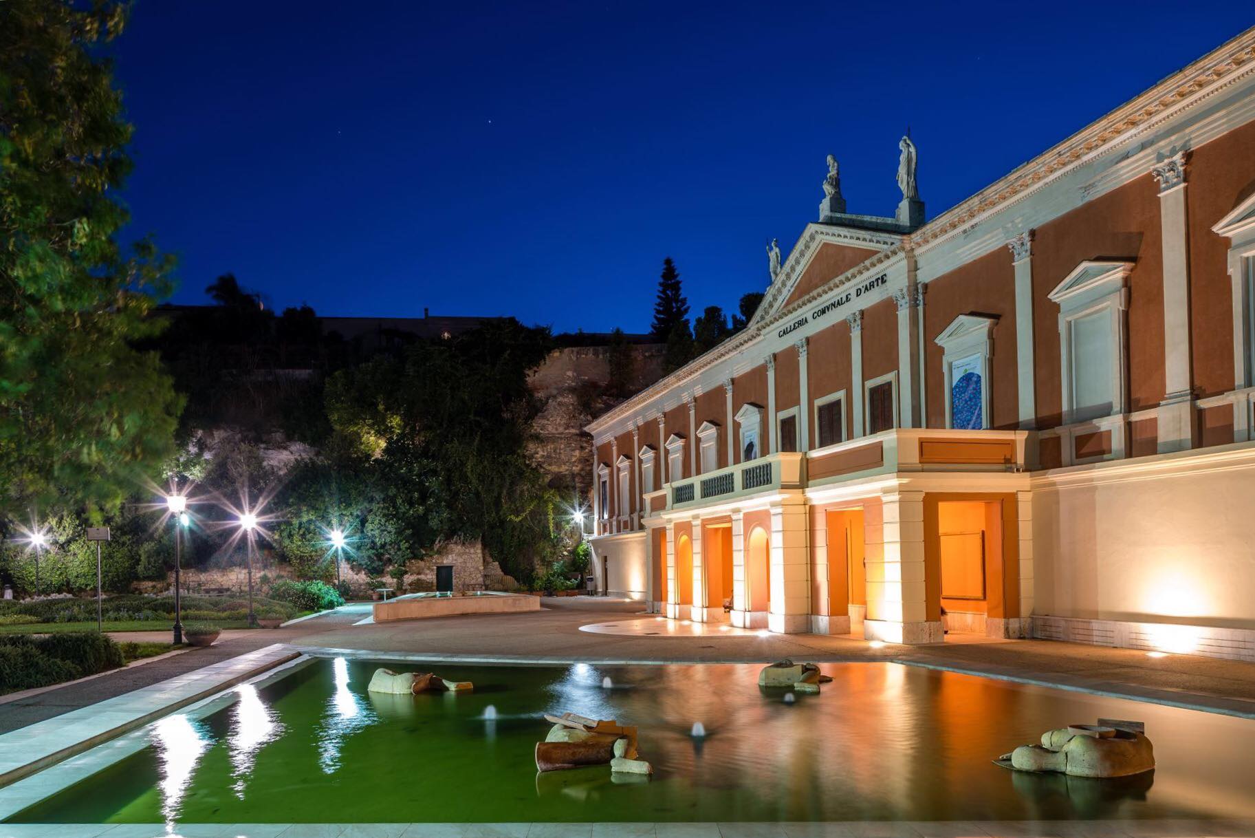
Municipal Art Gallery
One of Cagliari’s most beautiful green areas stretches across a ridge of the Buoncammino hill: a sort of ‘hanging garden’, with a long, spectacular tree-lined avenue. At the end of the avenue, you will notice the elegant Neoclassical façade of the former royal munitions depot, which has accommodated the Municipal Art Gallery since 1933. The military building was destroyed by an explosion and was rebuilt in 1828 based on a design by military engineer Carlo Boyl. After a century of use as a barracks and a warehouse and after further modernisation works, it became a museum. After crossing the garden, before entering, you can admire the façade of the building, with limestone friezes and a tympanum with three statues carved in Carrara marble above it.
Inside the ‘gallery’ there are two main exhibition areas: the first is the Ingrao collection, donated to the Municipality of Cagliari in 1999, which contains works by the greatest Italian masters of the 20th century, including Umberto Boccioni - with 31 works including paintings and drawings -, Giorgio Morandi and Mino Maccari. About 650 works form a collection of the main artistic trends of the last century and are kept in the rooms called ‘the collector’s rooms’. In the second area, you can admire the most important collection of works by Sardinian artists, especially between the early 20th century and the late 1970s. The artists represented, including the main personalities on the Sardinian artistic scene, went on a search for harmony between the ideas of contemporary art and the island’s cultural context. One room is dedicated to the plaster sculptures of Francesco Ciusa, including the famous ‘madre dell'ucciso’ (mother of the slain). Among the 74 works on show, there are also creations by Pinuccio Sciola, Costantino Nivola and Maria Lai. A collection of Sardinian ethnographic materials from the late 18th century and a large collection of prints are also on display.
The ‘gallery’ also accommodates the library specialised in the history of art and the ‘Reading Garden’, an initiative that allows you to borrow books and newspapers and read them outdoors. Educational courses, activities for children, meetings and cultural reviews are periodically promoted. The rooms are accessible to the blind.
The cultural itinerary can continue to the fortifications of the Castle district, crossing the spectacular Porta di San Pancrazio, to reach the Citadel of Museums, the ancient site of the royal arsenal and today the largest museum centre in Sardinia, which includes the National Archaeological Museum, the Museum of Siamese Art, the Anatomical Wax Museum, the Ethnographic Museum and the National Picture Gallery.
Santa Margherita di Pula
Almost ten kilometres of soft, golden sand lapped by shallow, warm waters in tones of green, with a sea that is so clear you can see right to the bottom even without diving. Santa Margherita is a pearl of southern Sardinia, the symbol of Pula, which extends to the west as far as another feature of the island, the coast of Chia (in the territory of Domus de Maria).
Santa Margherita di Pula is composed of a series of bays and beaches, almost uninterrupted, divided only by the rocks of small promontories, named according to the area (including Cala Marina and CalaBernardini), overlooking numerous luxury resorts including some which are among the island's most renowned, a destination for film and television stars, sports celebrities and top financiers.
The beaches are reached by small access roads next to the hotels or through the pine woods behind them, where you'll find hidden apartment blocks, villas and holiday homes. You'll discover unforgettable places, coves with super-fine, white tongues of sand, dotted with pink granite rocks, while the pines offer shade from the summer heat. The area is swept both summer and winter by a wind much appreciated by surfers. The sea bed is well-known among snorkelling and underwater fishing enthusiasts.
A short walk from Santa Margherita is the Pula nightlife, with its numerous events and aperitifs in Piazza del Popolo and Piazza di Chiesa, to combine with long walks and lots of sports. For example, you can go jogging along the tree-lined streets leading to Nora, where, not far from the beach, you'll discover the ancient Phoenician-Punic and later Roman town. To the east of the Nora archaeological park, the beach and church of Sant'Efisio, lies the beach of su Guventeddu, much loved by kite and wind surfers. Keep fit with a nature walk, and continue on to the nearby Nora laguna. Fall in love with the system of small channels and islands created by the delta of the Rio Arrieras, which hosts a lush, typically Mediterranean plant life and many species of birds.

San Vero Milis
It extends along the northwestern extremity of the Campidano, next to the ridges of the Montiferru massif and a quarter of an hour from the sea. San Vero Milis is an agricultural village with approximately two thousand 500 inhabitants, famous for the art of weaving, where baskets and cane baskets are made, as well as mandarin-growing and the production of Vernaccia wine, with its distinct fragrance of almonds. It is also famous for its wonderful coastline and, for cat lovers, there is the feline colony of Su Pallosu. Cereal-growing has always been the main activity: the village was first a Carthaginian granary and then a Roman one. Linked to this activity are its homemade bread and pasta. Other traditions are Su Carru 'e Is Padda, the San Vero carnival, Holy Week, with its climax during the Triduo Sacro (Holy Thursday, Friday and Saturday), and traditional men's and women's costumes. The Exhibition of New Wines takes place in November. In the village, the parish church of Santa Sofia stands out, dating back to 1604, with a small 'Gothic' rose window on its façade made of red trachyte and three Renaissance-style entrances, while inside there are Baroque simulacra and altars. Another church not to be missed is that of San Michele Arcangelo.
The territory features a large variety of settings: from the cultivated countryside to the dunes of fine sand in the coastal desert of Is Arenas, from the high limestone cliffs of capo Mannu and Su Tingiosu, a surfer's paradise, to the various pools, among which Sale 'e Porcus, an oasis protected by LIPU (Italian League for Bird Protection), which is also frequented by the greater flamingo and is an ideal place for birdwatching enthusiasts. The erosion of the limestone rock led to the creation of some of the most charming little coves and beaches on the Sinis peninsula. About twenty kilometres from the village, you will encounter its 'gems': S'Arena Scoada with its oceanic-tropical appearance, that opens up in front of the island of Mal di Ventre, the splendid and sheltered Putzu Idu with soft, white quartz sand, the small, delightful Mandriola, the splendid, multi-coloured Sa Mesa Longa, a genuine pool set between the cliffs, the peaceful feline oasis of Su Pallosu, one of the Pearls of the Sinis peninsula, the long, wide Sa Rocca Tunda, with its soft, golden sand, and the little pebbly coves of Scal'e Sali. Further on, there is the bay of Is Arenas. Along the coast, there are various towers, among which those of Saline, Scala 'e Sali and Sa Mora, built by the Aragonese as a defence against the barbarian incursions. The presence of humans in the territory from the 4th-3rd millennium BC, is confirmed by three Domus de Janas necropolises, among which those of Serra Is Aràus, with an 'oven-like' room and a well-entrance. About thirty Nuraghi date back to the Bronze Age, among which S'Urachi, one of the most important in Sardinia: to date, seven towers have been identified in the defence wall.