
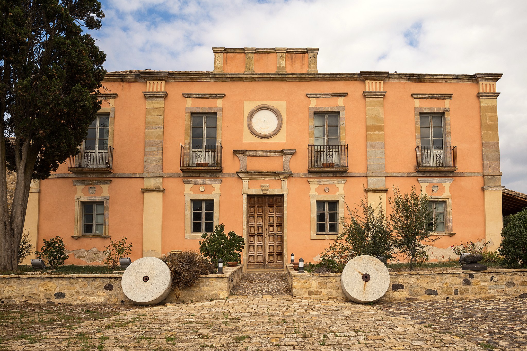
Villa Asquer
The prestigious 19th-century residential architecture preserves the memory of the family who not only constructed the house but established its agricultural activity and lived within. Villa Asquer, which was first a business hub and then a residence from 1920 to the end of the 20th century, belonged to the noble family of Ligurian origin. It is located in the historic centre of Tuili, a village in the Marmilla area at the foot of the Parco della Giara - part of which lies within its territory - within a splendid setting amidst cork trees, holm oaks, Mediterranean scrub, centuries-old olive trees, marshes, Giara horses and prehistoric sites.
The Asquer family became nobility following the marriage between Giovanna and Pietro Ripoll, the first Count of Tuili (1775). The villa was built in the mid-19th century using prestigious neoclassical forms attributed to the mastery of architect Gaetano Cima. The building was the fulcrum of the family headed at the time by the marquis and doctor Gavino Asquer, who managed the farm using innovative entrepreneurial methods.
The structure extends over six thousand square metres. At its centre is the main house, split over two levels. The ground floor contained the administration and servant rooms, whilst the first floor held the noble residence. The façade of the villa has large pilasters and a circular frame in the centre. In the large central courtyard, to the rear and sides, are the loggias, warehouses, olive groves, sheds and stables, once used for rural activities and now utilised for exhibitions and events. A must-see is the ‘Sala dello Scialle’, with its walls embellished with paintings centred on the embroideries of the shawls from Tuili, and the ‘Sala dei Cesti’, with authentic furnishings from the family’s legacy.
In the 1980s, the villa was purchased and restored by the municipality. Today, it is a cultural hub housing two cultural landmarks of the area: the olive and olive oil museum and the Sardinian musical instruments museum. The first, set up on the ground floor, illustrates the olive-growing tradition through images, stories and agricultural tools of the time, including a 19th-century oil mill and machinery from the second half of the 20th century. The museum honouring the musical tradition is on the first floor. An entire wall is dedicated to the rich collection of launeddas, an archaic wind instrument made with reed. Its sounds are diffused within the room with live melodies. Reed was also used to create the benas, sulitus and pipaiolus. One space is dedicated to percussion - tumbarinos, afuente, taulitas and matracas - with phonographs, gramophones, turntables and accordions.
The Villa Asquer complex extends over an entire block, overlooking the piazza of the parish church of San Pietro Apostolo, from which it is separated by a stone arch. The church, consecrated in 1489, has a single nave with three chapels on each side, with the third on the left being embellished with a starry vault with hanging gems, the only legacy of the original Gothic-Catalan layout. The façade concludes with a double crowning topped with an ‘Admiral’s hat’ form. The interior houses 19th-century marble decor and various works of art, including the altarpiece by the maestro Castelsardo, a 16th-century work considered the masterpiece of Sardinian Renaissance painting. In the historical centre, dominated by ‘courtyard’ houses characterised by portals from the end of the 19th century, another elegant neoclassical building stands out: Villa Pitzalis. One great cultural attraction is the ‘Sardegna in miniatura’ (Sardinia in miniature) park, where you can stroll amongst Nuraghe and dinosaurs on a reduced scale.
Fountain of Rosello
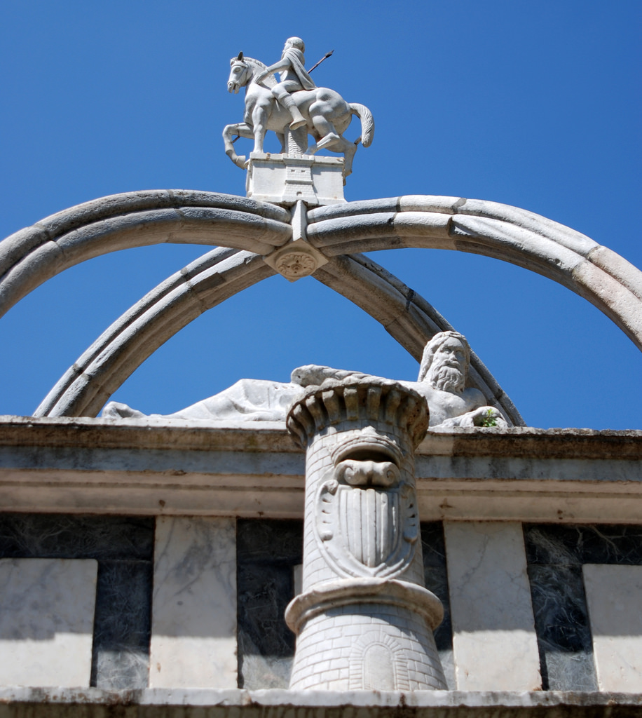
Symbol of Sassari and a unique monument in Sardinia, included in the 'Fountains of Italy' series of stamps, it contains the metaphor of time that flows like water, symbolized by twelve mouths, the months, and four statues, the seasons. Outside the ancient city walls, near the bridge of the same name, the fountain of Rosello was built at the beginning of the 17th century, in late-Renaissance style, giving a name to the district that arose around 1930, where the Masedu museum and the basilica of Sacro Cuore are located.
The sculptural complex is made up of two overlapping rectangular blocks that are linear, simple and white and dark grey colours, enhancing the lions' heads from which water flows. The statues representing the seasons rest on the mouths of dolphins: a girl with a garland of flowers (spring), Hercules with a crown of grapes and a bearskin (autumn), an old man resting (winter), a woman with ears of corn (summer), the only original, kept in Palazzo Ducale. The other three were destroyed during anti-feudal uprisings (1795) and were recreated thirty years later.
In the first order, with four corners, you will notice crenellated turrets symbolizing the city and others with the coats of arms of the Crown of Aragon. At the top, there are two crossed arches supporting the equestrian statue of San Gavino, a martyr from Sassari and protector of the town. To the south, you will see a river divinity, lying down, emblem of the Mannerism of the monument. In the lower block, you can read the dedicatory inscription with the date of the works (1605-6), created under Phillip III, which led to its current appearance.
However, its origins are much more ancient. The earliest evidence of its existence dates back to 1295. Over the centuries, the fountain underwent various interventions and was always fundamental for providing water. Indeed, from Roman times, the fountain of Gurusellu supplied water to the aqueduct of Turris Libisonis (now Porto Torres). Nearly two thousand years later, in the 19th century, a multitude of water carriers transported water from Rosello to the houses by loading the barrels onto hundreds of donkeys.
In the medieval old town centre of Sassari you will find its others symbolic monuments: religious ones, like the cathedral of San Nicholas di Bari and the churches of Santa Maria di Betlem and Sant'Apollinare, as well as civic ones, like Piazza d'Italia, and cultural ones, among which the G.A. Sanna museum.

Balai
A charming little cove, sheltered by limestone cliffs and framed by spectacular scenery. The soft golden sand, the crystal clear water, the bright colours of the sea, the white rocks and the lush green park behind it make Balai the most beautiful and popular beach in Porto Torres, a town in the centre of the Gulf of Asinara. The beach, of sand mixed with little pebbles, is just a hundred metres long and, therefore, it’s often crowded in the summer. It is famous for an unusual tradition, the New Year’s Day swim. You will find it in the eastern outskirts of the town, on the Cristoforo Colombo promenade, one kilometre from the centre. It's worth visiting all year round, for pleasant walks along the pedestrian and cycle path that runs alongside the Porto Torre coast and, passing by Balai and the other small city beaches - Renaredda and Scoglio Lungo -, it stretches to the beginning of the very long (eight kilometres) and wide beach of Platamona, with a pond and pine forest around its border.
The seabed in Balai is sandy and the waters are almost immediately deep, with a few rocks on the edges, ideal for snorkelling. The limestone reefs that surround it, pierced by small caves, are an attraction for expert divers. The best-known point is the Rocca manna. Close to the beach is the Chico Mendes park, with palm trees, lawn, aromatic plants and colourful flowers, almost suspended over the cove. In the surrounding area, you will find numerous services for bathing, bars and restaurants.
To the west of the bay, standing on a sheer cliff, is the small church of San Gavino A Mare, better known as Balai vicino, which is where the beach gets its name. The sanctuary, was built in the mid-19th century, has a simple structure, without an apse or bell tower, and a bare, very white façade, contrasting with the emerald green sea. It stands next to a cave used as a tomb, where, according to tradition, the martyrs of Turrita, Saints Gavino, Gianuario and Proto were buried. Moving on for a kilometre along the coastal road, you will come across another small church, named San Gavino Decapitato (St Gavinus beheaded) or Balai lontano (distant Balai), with a single nave. It is said that the two sanctuaries were built, respectively, in the place where the bodies of the three martyrs were thrown into the sea and in the place they were found. During the Festha manna, in May, their statues are carried in a procession that reaches Balai and starts from the splendid basilica of San Gavino, the oldest – built in 1060 – and biggest Romanesque church in Sardinia, as well as the symbol of Porto Torres, in which the remains of the three saints are kept.
From Porto Torres, you can reach the Asinara National Park by ferry, where you can discover the island's natural heritage and secular history. Nature and history are often intertwined in the Porto Torres area. Today's main seaport in the north of the island has its ancestry in Turris Libisonis, the only colony in Sardinia composed exclusively of cives and possibly founded by Julius Caesar himself. Excavations have unearthed the ruins of monuments - thermal baths, domus with mosaics, porticoes and tabernae -, which can be visited in the archaeological park inside the city, and countless artefacts, kept in the Antiquarium Turritano museum. Outside the city, ‘spanning’ the rio Mannu, is the biggest bridge built by the Romans on the Island (1st century AD), 135 metres long and still standing almost intact. The main prehistoric site is the necropolis of su Crucifissu Mannu, with 22 domus de Janas dating back to the 4th-3rd millennium BC, while the most important piece of medieval evidence, after the basilica of San Gavino, is the Aragonese Tower, built between 1323 and 1326 at the behest of Alfonso V of Aragon.
Golden sands of Pistis
A vast stretch, a kilometre and a half long, of hills of fine, golden sand, modelled by an exceptional sculptor, the northwesterly mistral wind, which gives them unique and fascinating forms. The Golden Sands of Pistis, also known as Is Arenas 'e s'Ollastru (‘the sands of the water and of the wild olive’) border, in the south, with the splendid Torre dei Corsari and represent the northernmost beach of the Costa Verde, in the territory of Arbus. Patches of twisted junipers - one transformed by the poet Tziu Efisiu Sanna into a dwelling (the House of the Poet) - mastics, wild olive trees and other Mediterranean shrubs cover the 'Little Sahara', also coloured by hoary stock, sea daffodils and yellow hornpoppy in the springtime. Through the dunes, which are up to thirty metres high, upon your arrival, you can see the crystal clear waters that become emerald green in the sunlight.
The beach can be accessed by the persons with disabilities, has parking, dining and refreshments areas, services and bathing equipment rentals. Those who love the rocks will also be satisfied: at the end of the strip of sand, you will see basalt rocks standing out. S'Enna e S'Arca is located on the northern side, an impervious place, featuring basalt and sandstone shaped by the wind and the force of the sea, which conceals a series of hidden coves and is a destination frequented by fishing enthusiasts. The sandstone was also the object of ancient activities, to which a Punic-Roman quarry bears witness and can be seen from the entrance to the village of Pistis. Continuing on towards the beach, the rocks merge with the sand, creating natural pools, perfect for children.
The sea of the Costa Verde is all spectacular and wild. The dunes and the Saharan environment are a characteristic not only of Pistis and Torre dei Corsari, but also of Funtanazza, Portu Maga of Marina di Arbus and of the two undisputed ‘pearls’ of the coast, the ‘desert’ of Piscinas and the ‘talking’ beach of Scivu (so-called due to the sound the sand makes when you walk upon it).
Capitana
Its sandy shore is divided between two coves. The first is smaller and crescent-shaped and the second is longer, stretching towards a rocky promontory. It is narrow, due to the continuous erosion caused by the sea, and runs for almost two kilometres alongside the locality of the same name, in the territory of Quartu sant’Elena, town with the third largest number of inhabitants on the Island. The beach of Capitana characterises a wide stretch of the Cagliari-Villasimius scenic route and appears with its bright colours at the end of a straight road, just before entering a landscape where the little villas give way to the greenery of the poplars, tamarisks and eucalyptus trees and also to small elevations covered in Mediterranean scrub and spectacular rocky cliffs.
You will have access to the beach via various detours from the SP 17 provincial road and you will find a strip of fine white sand that quickly makes way for the water’s edge, where shallow waters and a sandy seabed gently slope towards the open sea. The sea is transparent near the shore and the various shades of blue get darker as you look further out to sea, gradually becoming a deep blue. When the northwesterly mistral and southeasterly scirocco winds blow, Capitana becomes an irresistible attraction for surfers and also for kitesurfing and windsurfing enthusiasts, for whom there is no lack of schools and equipment rental services. To the west of the beach, there is a well-equipped marina that has two docks and was awarded the Blue Flag in 2020 as a tourist port. In this area, the seabed near the rocks becomes pebbly and, thanks to the transparent sea, snorkelling allows you to observe the abundance of marine animals.
There are plenty of services nearby, such as bar-restaurants, pizzerias, hotels, campsites and sports fields. Proceeding eastwards, there is a small beach of pebbles and rocky outcrops near the promotory: this is Baia Azzurra, ideal for relaxing, as it is cosy and private, thanks to the rocky stretches surrounding it. There is a handy wooden walkway, where you can sunbathe and enjoy the view. On the left, at the foot of the rocky spur, there is a part of the coast called the ‘cove of the pools’. You will be surprised by the transparency of the water, with its turquoise hues, where white rocks smoothed by the waves emerge.
You can also explore the historical and archaeological traces left in the area, by visiting the Carlo Baldi military battery, a fortification dating back to the 1930s, and the nuraghe Diana, a trilobate building from the middle of the 2nd millennium BC. According to popular legend, the Nuragic fortress guards a fabulous treasure: the booty accumulated by a pirate and his beloved, ‘La Capitana’, who waited in vain for his return, scanning the sea from these shores, and honoured by the local people with the name of the place.
Armungia museums system
A series of places narrate the history and culture of the Gerrei. Armungia is a 'open-air' museum that includes the ethnographic museum of sa Domu de is Ainas, the blacksmith's workshop, the mineralogical museum, the Emilio and Joyce Lussu history museum and the Armungia nuraghe dating back to the 5th-4th century BC, which rises majestically in the centre of the village - an almost unique case of Nuragic architecture within an inhabited area - and which can be accessed from the ethnographic museum. The nuraghe, which gives its name to the village that developed around it, is the starting point in the itinerary of the museum system: walking the stone streets of the village you will discover all the cultural sites, each with its particular historical, artistic and archaeological value, all 'mirrors' of the local identity.
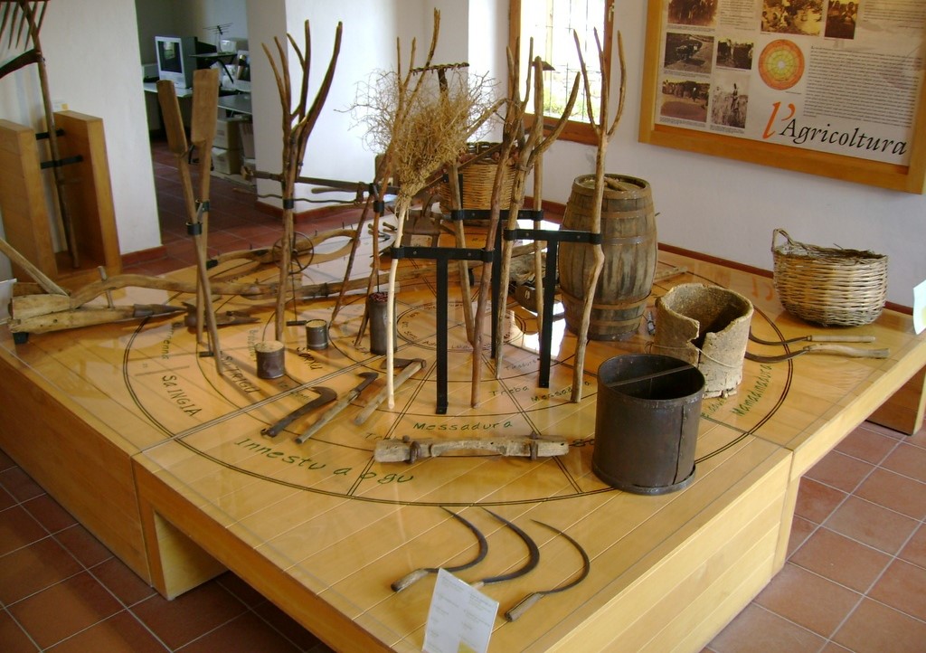
Sa Domu de is Ainas, 'the home of work tools', uses a heritage of about 600 pieces to reconstruct the agro-pastoral culture of the communities of Sarrabus-Gerrei. The location is the 19th century town hall: the exhibition is divided into several rooms with illustrative panels, documents and images of the era, in addition to the case minime, three small stone houses that host the multimedia archives. The first two rooms display traditional clothes and jewels, and the tools of traditional female activities, especially weaving on the loom and bread making. The "agriculture room" is characterised by a large wooden solar calendar, which illustrates in Sardinian the phases of agricultural work; the "territory" room illustrates the life of the community, including cheese making. The "crafts room" is dedicated to the blacksmith's activities. The section refers to the Blacksmith’s forge, on ferreri, which you can visit in the museum itinerary through the streets of the historic centre: it is a small building of the early 19th century, and has been a craft workshop since 1928. On the ground floor you will find the shoeing frame, forge and courtyard with the sandstone wheels; on the first floor the work is recalled in its symbolic values with testimonies and vintage photos and the story of the Piedmontese family Vellini, who once owned the home.
The pride of the museum itinerary is the exhibition dedicated to Emilio Lussu and his companion Joyce Salvadori, which traces the personal and political experience of two key figures in Italian 20th century democracy. You can admire it in the casa del segretario, an imposing manor house built between the late 19th and early 20th centuries. The "photo room" traces the biographical events: childhood at Armungia - to which Emilio remained very attached, the Great War, the foundation of the Sardinian Action Party, the anti-fascist struggle, and the political experience of rebuilding Italy. The "multimedia room" offers films, period interviews and historical documents - in particular a manuscript letter to Piero Gobetti, in 1924; the "books" room is dedicated to Lussu's literary works. Other spaces host permanent exhibitions, including "Joyce Lussu: the path of a woman in the history of the 20th century".
Terralba
Between the inlets of the Laguna di Marceddì and the Stagno di San Giovanni, where Neapolis once reigned, a city founded by the Phoenicians and subsequently occupied by the Punic, then Roman and Byzantine populations, stands Terralba, a small town on the Campidano plane in the Oristano sub-region, 25 kilometres away. Known for its gavina watermelons and the communal winery (established in 1948), which produces monica and nuragus wines, Terralba is the second most populous town in the Province of Oristano, with over ten thousand inhabitants. The lagoon and pond, which together form a protected ecosystem stretching over 1,800 hectares, are home to over 5,000 birds. There are rare species such as the purple heron, western marsh harrier, pink flamingo and the western swamphen. The area contains many fish varieties, hence why fishing has always been practiced. From the hamlet of Marceddì, twelve kilometres from the city, come eels, mullets, wedge clams and mussels (nieddittas). The village, enriched by the Museo del Mare (Sea Museum), comes alive after Ferragosto on the occasion of the Sagra della Madonna di Bonaria, with processions on the ground and on the pond.
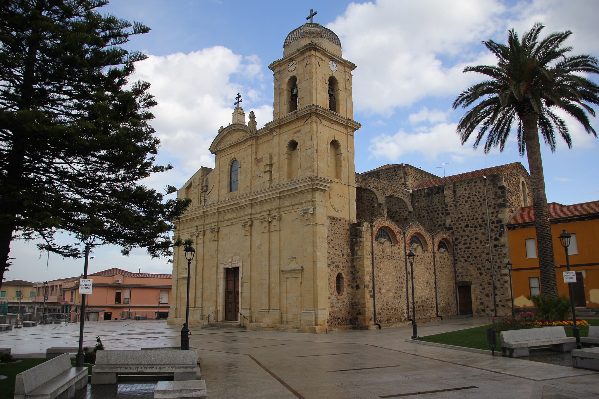
Legend has it that here once stood the village of Osea, founded by Hercules Libycus some 364 years before Rome (1000 BC). The Saracen raids forced the inhabitants to move to nearby Neapolis, surrounded by walls with angular towers and aqueducts, the ruins of which can be seen in the Stagno di San Giovanni. The city, grand and beautiful in the late Imperial era, was also important in the early Middle Ages. It fell around the year 1000 at the hands of the Barbarians. Perhaps in 1017, the survivors founded Terralba, which replaced it as the capital of the curatoria within the Giudicato of Arborea and as the bishop’s seat. The toponym appeared in 1048, coming from terra (land) and alba (clear). With the Neapolitans, Bishop Mariano I was also transferred. At that time in Terralba, there was the Chiesa di Santa Maria, the episcopal ‘dimension’ and the immediate prosperity providing the resources to build in 1144 the Romanesque church in honour of the patron saint, San Pietro. Built between 1820 and 1933 on this ancient (ruined) layout was the new majestic Cattedrale di San Pietro, in late-Baroque form, which contains Neapolis capitals and the former cathedral, baptismal font and wooden pulpit from the 17th century, along with a precious silver cross and statues of the saint and of the Madonna. The patron saint is celebrated at the end of June. Another sanctuary in the inhabited area is that of the Church of San Ciriaco, founded in 1741 and re-consecrated in 1958, which preserves a painting by Padre Lilliu, a sarcophagus of Mary as a child, a tabernacle from the previous building, and two statues of the saint, the smaller of which is used during the procession on 8th August. From the beginning of the 20th century are two Art Nouveau buildings, the elementary schools in Via Roma and the municipal house. From the feudal era, there are three coastal towers: Flumentorgiu, Marceddì and Torre Nuova. The ‘daughter’ of the 1919-28 reclamation is the fraction Tanca Marchese where, in mid-January, the Fuochi di Sant’Antonio Abate are lit, traditionally beginning of the carnival, characterised by allegorical parades with zeppole and malloreddus alla Campidanese. The first human settlements (in San Giovanni, San Ciriaco and Bau Angius) date back to the 7th millennium BC, thanks to the fertile soils, fish-filled basin and obsidian deposits of Monte Arci. Terralba also offers Nuraghic sites, including the Villages of Pomata and Coddu su Fennugu, along with a density of Punic testimonies (late-5th to late-3rd century BC) unlike any other Mediterranean context. In the locality of Pauli Putzu, ten Roman tombs were found together with grave goods, whilst a basin from a farm was discovered in the city. Some finds are kept in the Eliseo historical-ethnographic museum.
Torre dei Corsari
A desert bathed by emerald sea and swept by the wind that moulds it and turns it into an ideal destination for surfers. Torre dei Corsari is one of the pearls of the Green Coast, in the Arbus territory, and it is named after the Spanish tower called Flumentorgiu (17th century), a watchtower against attacks by Saracen pirates. From the promontory, you can admire, to the south, a bay with calcareous cliffs, while to the north you can see the immense Is Arenas ‘e s’Acqua e s’Ollastru beach, all the way to the delicious secluded coves and steep rocks, a paradise for fishing aficionados.
The beach is one and a half kilometre long: golden dunes of astonishing beauty, they look like hills, clumped and shifted by the endless action of the Mistral.
The colour of the sand, which is covered by sea lilies, wallflowers and sand poppies in spring, contrasts and highlights the landscape behind, made of hills covered by Mediterranean scrubs, with giant strawberry trees, junipers, brooms and mastics. From every angle and at any given time, Torre dei Corsari offers you unforgettable views, and, in the evening, marvellous sunsets. The beach is accessible to disabled people, has a parking area (for campers as well), and it is possible to rent umbrellas and beach chairs. There are also plenty hotels, cafés and restaurants.
The sea of the Green Coast is spectacular and wild, rarely calm, always demanding respect. The dunes are a feature shared by the entire coast: in the two kilometres of the Sabbie d’Oro of Pistis, where there is a juniper tree turned into the house of poet Tziu Efisiu Sanna (The Poet’s House), in Piscinas, a gem of the Green Coast where even Sardinian deer go for walks, and in the “talking” beach of Scivu, so called for the sound it makes when you walk on it. Other wonders include Funtanazza, Marina di Arbus, Portu Maga, where there is also a diving centre, and Capo Pecora, the southernmost limit of the Arbus coast, a popular destination among scuba divers and fishermen.

Delitala Collection
This art collection consists of 66 graphic artworks: woodcuts, etchings, lithography and two fine oil paintings donated by Delitala to the Municipality of Orani on his one hundredth birthday.
The works on display include the portraits of the artists' mother and father and religious scenes, with dramatic scenic compositions, made more impressive by the variety of drawing styles.
The scenes of village and farm life, from the bomborombò folk dance to grape crushing, open as many windows onto the traditional lives of the Sardinian communities. The engravings 'Gente del 1908', 'Gente del 1918', 'Eroi', 'Gente del 1938-Aratori' portray specific moments in the lives of the mountain communities of the Barbagia area, governed by an archaic unwritten code of honour.
Mario Delitala's works belong to a vibrant period in the island's art, when Sardinian engravers were recognised nationwide both for their exquisite mastery of technique and for the dramatic, lyrical and poetic quality of their work.
Address: piazza Italia, 7 (Comune) - 08026 Orani Phone 0784 74123- 0784 74462 Managing Agency: Municipality of Orani Manager: Municipality of Orani.
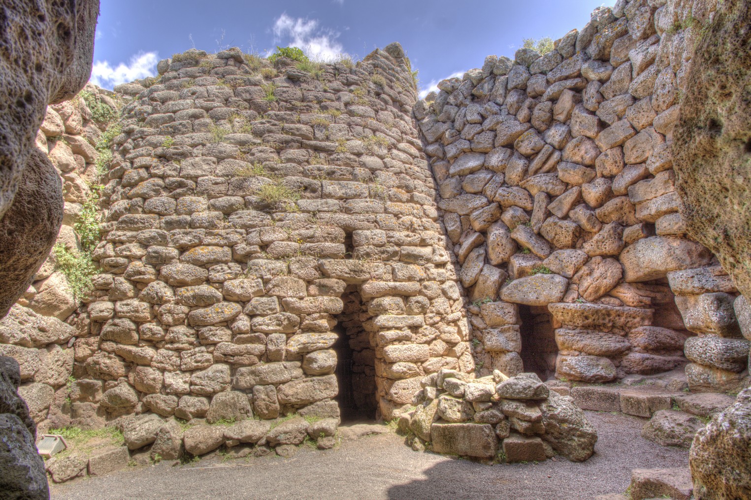
Nuraghe Arrubiu
The name of Red Giant is due to its grandiose size and the hints of red lichens that colour its basalt stone walls. The complex of Nuraghe Arrubiu, in the territory of Orroli, stretches for five thousand square metres and consists of a central tower (fortified tower) that is 15 metres high - originally it was double this height - surrounded by a formidable bastion formed by five towers, in turn surrounded by a defensive wall with seven towers joined by curtain walls. Inside it there are various courtyards. To the southeast there is another defence wall with five towers joined by masonry. There are a 21 towers in total. Within the fortified wall, of which the first of three floors is still remaining, by walking along a narrow passageway, you will reach the central room, that contains a fireplace and a ritual vase. The (false) tholos roof is still intact, as in some of the smaller towers.
In the courtyards, platforms, cisterns, fireplaces, niches, steps, entrances, corridors and covered rooms have been unearthed. All around there are numerous remains of huts. Along the eastern side there is a large, round one: it is the hut used for meetings, with a seat along the perimeter and a fireplace in the middle. The monument 'lived' between the 10th and 9th centuries BC, in alternating phases. After a collapse, it remained uninhabited until the 2nd century BC, when the Romans turned it into a wine-producing workshop: two tanks and tools for pressing the grapes bear witness to this. The date and importance of the site are confirmed by the artefacts: there is pottery imported from Peloponnesus which also confirms contact, which was not sporadic, with the Mycenaean civilization.
The archaeological area of Orroli is at the centre of the gentle hill of Pran' e muru, that watches over the territory along the Medio Flumendosa lake. The gorges, into which the river flowed, are now partly submerged by two artificial lakes. A territory deeply marked by the presence of man since prehistoric times, as is confirmed by the extraordinary concentration of vestiges from the past: from the Neolithic to the Bronze and Iron Ages to relics from the Roman Period and the Early Middle Ages. The Arrubiu was the stronghold, around which satellite nuraghi gravitated, which dominated strategic points and access roads. Near the complex, there is the Tomba dei Giganti della Spada. In the park of Su Motti, in a forest of downy oaks, there is a necropolis containing 15 Domus de Janas. In the village, there is the House of the Nuraghe Arrubiu, a museum created out of an ancient noble residence that includes twelve rooms in which the results of the excavations in 1981 are on show.