

Costa Serena
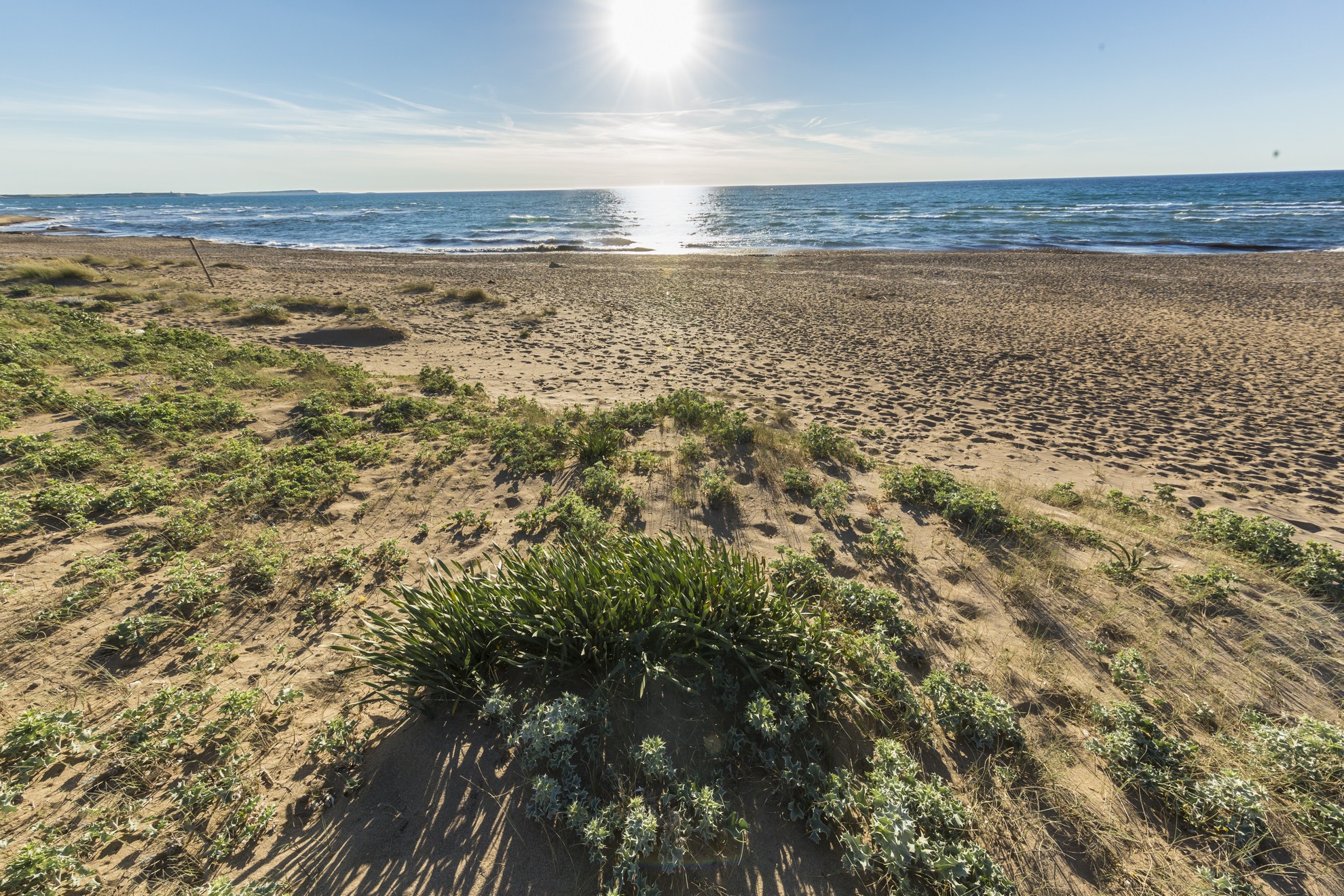
The vegetation almost reaches the water, as if the myrtle and helichrysum bushes were tempted to dive into it, enchanted by the turquoise reflections of the sea. The greenery behind it surrounds a lagoon, while in front, it covers a small island. This is the captivating landscape characterising the beach of Costa Serena, one of the stretches of the Palau coast. The beach extends in a crescent shape of medium-fine grained golden sand. On the right, you will see a small port, while the view in front is embellished by a rocky islet entirely immersed in Mediterranean scrub. The beach is never overly crowded. It is suitable for children, thanks to the shallow waters, and is sheltered from the winds blowing in from the north. It is also frequented by water sports enthusiasts, especially lovers of windsurfing and kayaking. In addition to relaxing on the beach, swimming and enjoying sports on the sand and in the sea, you can stroll peacefully along the banks of the salt water lagoon behind it.
Beyond a small stretch of coast dotted with rocks, the coastline of Padula Piatta extends to the south-west and is also known as Cala Petralana, from the name of the river that flows to the beach, dividing it into two parts. The sand is soft and cream-coloured, with a sea of shimmering colours due to the reflection of the sunlight on the surrounding vegetation. You might want to linger on the beach at least until sunset and admire the wonderful colours as the sun sets on the horizon, the islet of Costa Serena and, further away, s’Isuledda or Isola dei Gabbiani (Island of the Seagulls). It is really a peninsula, connected to the mainland by a 50-metre-long sandy isthmus that opens out like a fan on two beaches, a paradise for sailing and surfing: Porto Pollo to the east and Arenaria to the west.
A few hundred metres as the crow flies separate the beach of Costa Serena from the Fortress of Monte Altura, evidence of the anti-French defence system that characterises the Gallura coast and the islands of the Maddalena Archipelago. It was built towards the end of the 19th century in local granite and, along with the batteries of Capo d’Orso and Baragge, it helped protect the northern coast. It was a ‘fortified citadel’, surrounded by walls, and the buildings within it were used as lodgings, dormitories, warehouses, workshops and even gardens and vegetable gardens. From the fortress, you can admire a breathtaking view of the Maddalena Archipelago. Also set in the stone and with a view of the open sea, you’ll find the Talmone military battery, which is at least a century older and can be reached via a path that starts just north of Costa Serena. You can imagine the soldiers wandering between the barracks and the turret, and in the lookout posts, always alert, staring out at the blue.
Valledoria
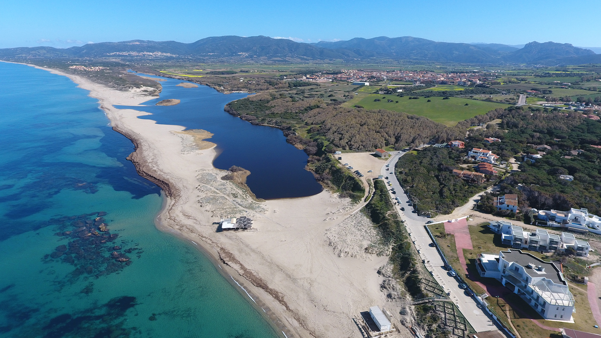
In the lower Coghinas valley, Valledoria accompanies the third river of the island to its mouth and faces the heart of the Gulf of Asinara, surrounded by lush landscapes. Valledoria is an agricultural and tourist town with over 4,000 inhabitants, with its main cultivation being artichokes, protagonists of cultural events in April and the basis of the local gastronomic tradition, whilst the processing of gold and coral forge the strong artisan tradition. Valledoria has been an independent municipality since 1961, arising from the merger of the localities of Baia Verde, Codaruina, La Ciaccia, La Muddizza, Maragnani, San Pietro (and Santa Maria Coghinas, which then became independent in 1983), firstly being the hamlets of Castelsardo and Sedini. The centre is Codaruina, whose name refers to the ‘periphery of the ruins’ of the ancient and glorious city of Ampurias. The original agglomeration was formed by the influx of agricultural entrepreneurs from Gallura who occupied the fertile and vast depopulated plains, while the toponym ‘Valle dei Doria’ derives from the noble Ligurian family that dominated the Anglona historical region in the 13th century.
Between the end of the 20th and beginning of the 21st century, numerous tourist facilities and services were built to enhance the seven kilometres of soft and golden sands, interrupted only by the outlet of the Coghinas river and some rocks in Maragnani. The San Pietro beach offers a contrast in colours with the sparkling sand and blue sea. The Baia delle Mimosa is then a stretch of white sand framed by dunes covered with greenery. San Pietro and La Ciaccia are destinations for those who enjoy breezes and kite surfing, coming from all around Europe. The whole territory is an exploration of nature: the plain is dotted with abundant gardens, lush pines and eucalyptus woods, gentle elevation and plentiful water. Before entering the sea, the Coghinas river forms a wetland extending over 50 hectares, the lacustrine area of the Valledoria beach, inhabited by herons, anatidae, widgeons, dabbling ducks and, along the banks in the reeds of rushes, tamarisks and willows, by coots, moorhens and water rails. Sea bass and mullet swim in the brackish waters. The area is ideal for horse riding, trekking, snorkelling, kayaking, sport fishing and sailing.
The first settlements in the area were on the hills of Muddizza then in the plains, as the swamp gave way to cultivable land. The fecundity, easy access from the sea and the navigability of part of the river all contributed to the fortunes of Ampurias, to which the Sardinian Church attributed great importance. Indeed, it was amongst the first episcopal hubs of the north, maintaining its authority until 1503 and strengthened by incorporating the diocese of Civita (Olbia). The mouth of the Coghinas river constituted an integrated port system, which the excavations in Zilvara and Santa Maria Maddalena helped bring to light. Documenting its evolution is the archaeological museum of the village, which also exhibits stelae from a Roman necropolis.

Porto Botte
The beach of Porto Botte has coarse sand mixed with pieces of seashell. There is the added bonus of a pool nearby where it is possible to admire flamingos and other migratory aquatic birds.
Cala Cipolla
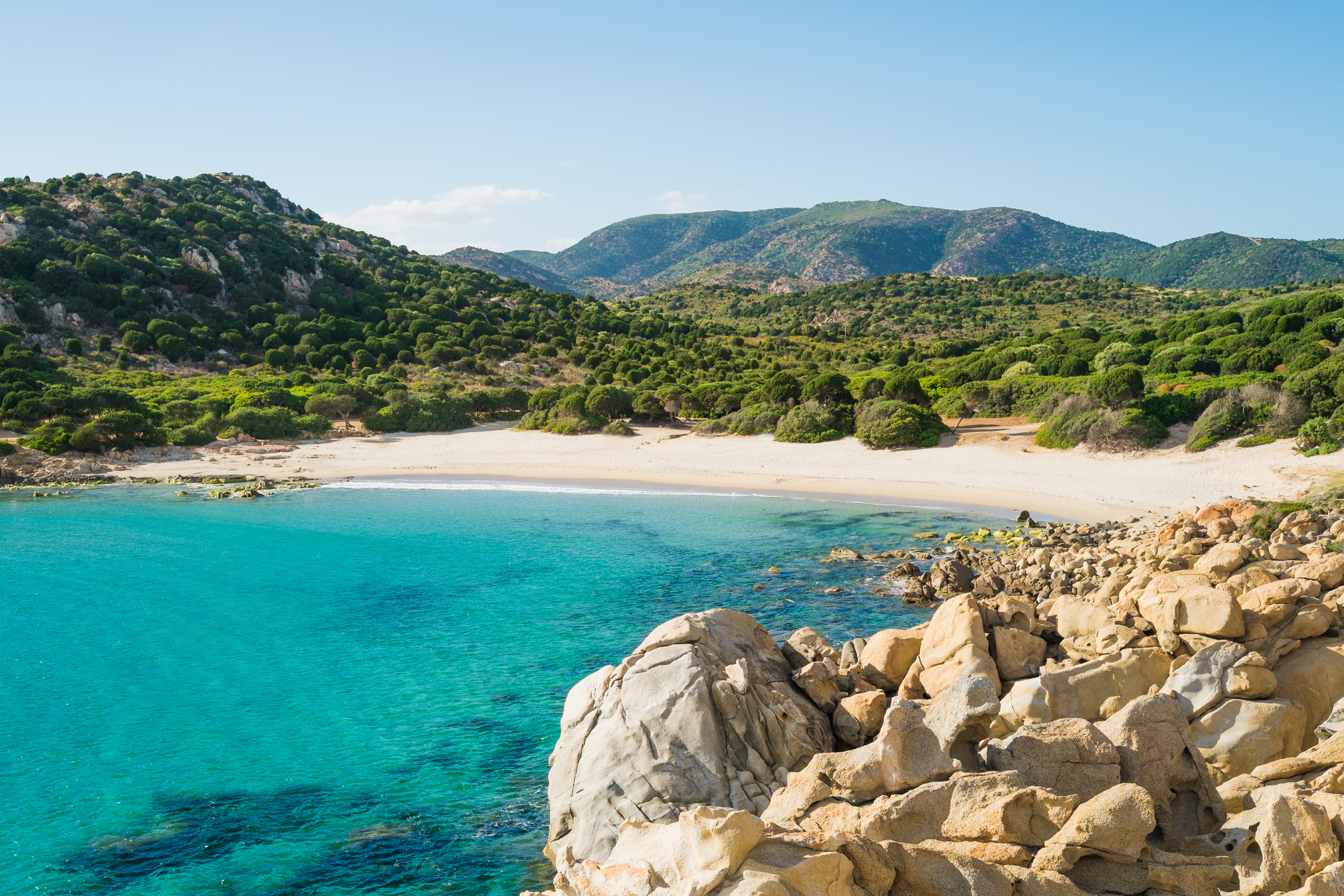
A charming stretch of fine, golden sand, enclosed between two pink granite promontories that stretch towards the sea, forming a natural pool. Behind it, there are sand dunes with Mediterranean vegetation and a pine and juniper forest. Cala Cipolla has a distinctive appearance with solitary, wild nature: it is one of the most captivating beaches of the Chia area, in the territory of Domus de Maria, three quarters of an hour from Cagliari. It is a little to the east of the promontory of Capo Spartivento, over which a lighthouse stands, accessible via a path, from which you can enjoy a view of the entire southwestern coast.
The splendid little cove is hidden between the hills and is characterized by a transparent sea, with iridescent colours that range from deep blue to green. The sandy seabed has shallow waters for several tens of metres from the shore, making it perfect for children. Every now and then, small rocks interrupt the uniformity of the waters. All around, the Mediterranean scrub frames the little cove. It is an ideal destination for surfers and it is popular with those who like underwater fishing and scuba diving. The car park is four hundred metres from the beach, where there is also a kiosk-bar.
The fine, golden sand is typical of the entire Chia coast, which is one of the most popular tourist locations in Sardinia: over six kilometres of dreamy coves and beaches that you can admire from the 17th-century Aragonese tower. A promontory separates Cala Cipolla from Su Giudeu, a beach used in films and advertisements. Further to the east, there is Sa Colonia, a kilometre of sand between two promontories, Cala del Morto, a small, sheltered beach with shallow waters, and Cala della Muscia, which can only be reached via the sea. Not to be missed is Su Cardolinu (meaning mushroom), a little island joined to the mainland by an isthmus of sand, where the tophet of the Phoenician city of Bithia (8th century BC) was unearthed, and can be visited on foot from the beach of Porticciolo. Close to it, there are two ponds: you will notice and take close-up photographs of the great flamingos, in the company of herons, coots and Great Cormorants.
San Francesco - Iglesias
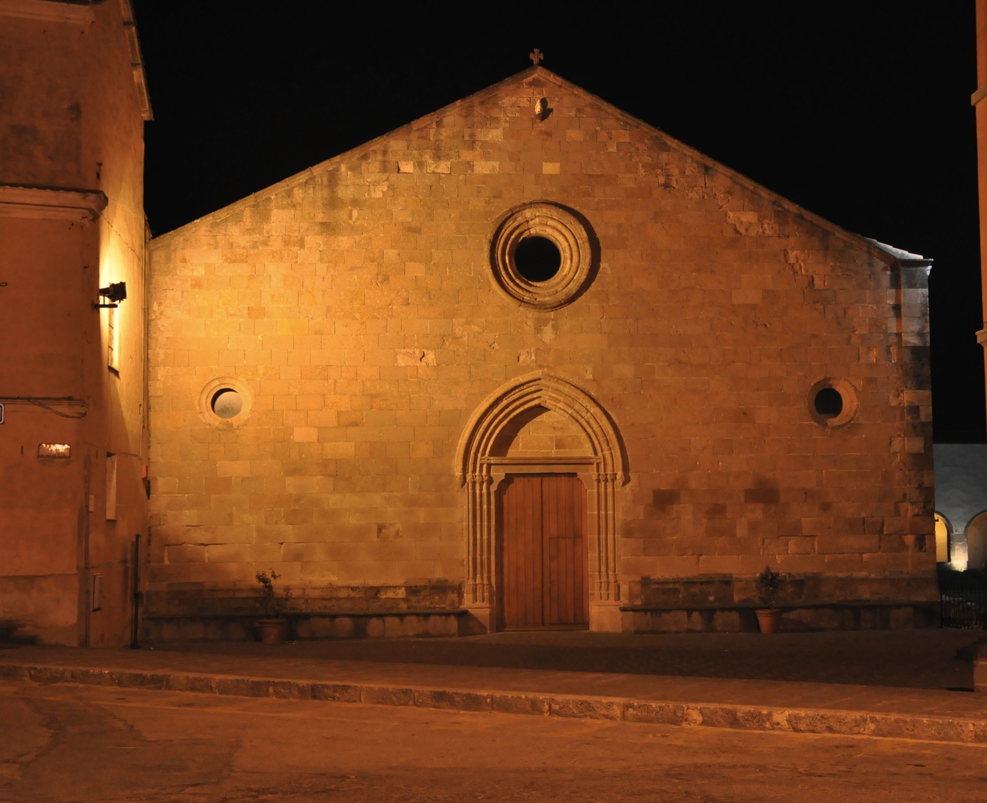
There is no certainty about when the Franciscans arrived in Iglesias: according to one theory they were already present at the time of the Pisan domination, while others think that they arrived after the power was seized by the Aragonese Crown (1324), which imposed the religious order it preferred on the city. In both theories, the first building of the Church of San Francesco, one of the main examples of Gothic-Catalan architecture in Sardinia, must have emerged later. It is not even clear whether or not it was constructed on pre-existing Benedictine structures. In any case, the present-day building is a 16th-century renovation, with subsequent interventions that did not change its general appearance. A few engravings of decorative elements are helpful in confirming its origin: a capital and a holy water font show the date 1558, while the year 1584 appears in the chapels on the sides of the presbytery.
On the gabled façade, made of red trachyte ashlars, you will notice two oculi and a rose window, in line with the entrance portal, decorated with jambs in bundles and monolithic architraves with a pointed relieving arch. The interior has a single nave, divided into seven bays, with a wooden roof. Various capitals bear coats of arms and inscriptions: in addition to the year of installation (or completion of the works), you will notice the coat of arms of the Franciscan order (two crossed arms) and of the Iglesiente municipality in the Spanish period. The apse is narrower and lower than the nave, closed by an ‘umbrella-shaped’ vault. On the sides of the nave, seven chapels open up per side and it has been suggested that the third on the left dates back to the original fourteenth-century church building, because it is very different from the others: the entrance arch is smaller and the roof, with a cross vault, is plastered. On the back wall of a room added to the first chapel on the left, you can admire the Retable of San Francesco, a work attributed to Antioco Mainas, a painter from Cagliari of the Stampace school. The altarpiece was painted in tempera and oil around 1560 and has the double triptych pattern, with a five-compartment predella. Among the scenes painted in the compartments, there is the Crucifixion, a Madonna and the Stoning of Saint Stephen.
Iglesias already has Catalan-Aragonese traits in its name, which continue to appear in the city’s traditions, such as the Easter Holy Week rituals, particularly during the processions of the Mysteries. Another event not to be missed, in mid-August, is the medieval historical parade. Among the monuments, the Castle of Salvaterra, built by the Pisans, and the Cathedral of Santa Chiara, dating back to the Middle Ages, stand out. For over a century, the Iglesiente area was the centre of the historical mining period, while today it is part of the Geo-mining Park of Sardinia. In addition to the city museums, you can visit the mine of Monteponi and the mining sites along the coast of Nebida and Masua, among which the spectacular tunnel of Porto Flavia.
Nuraghe Arresi
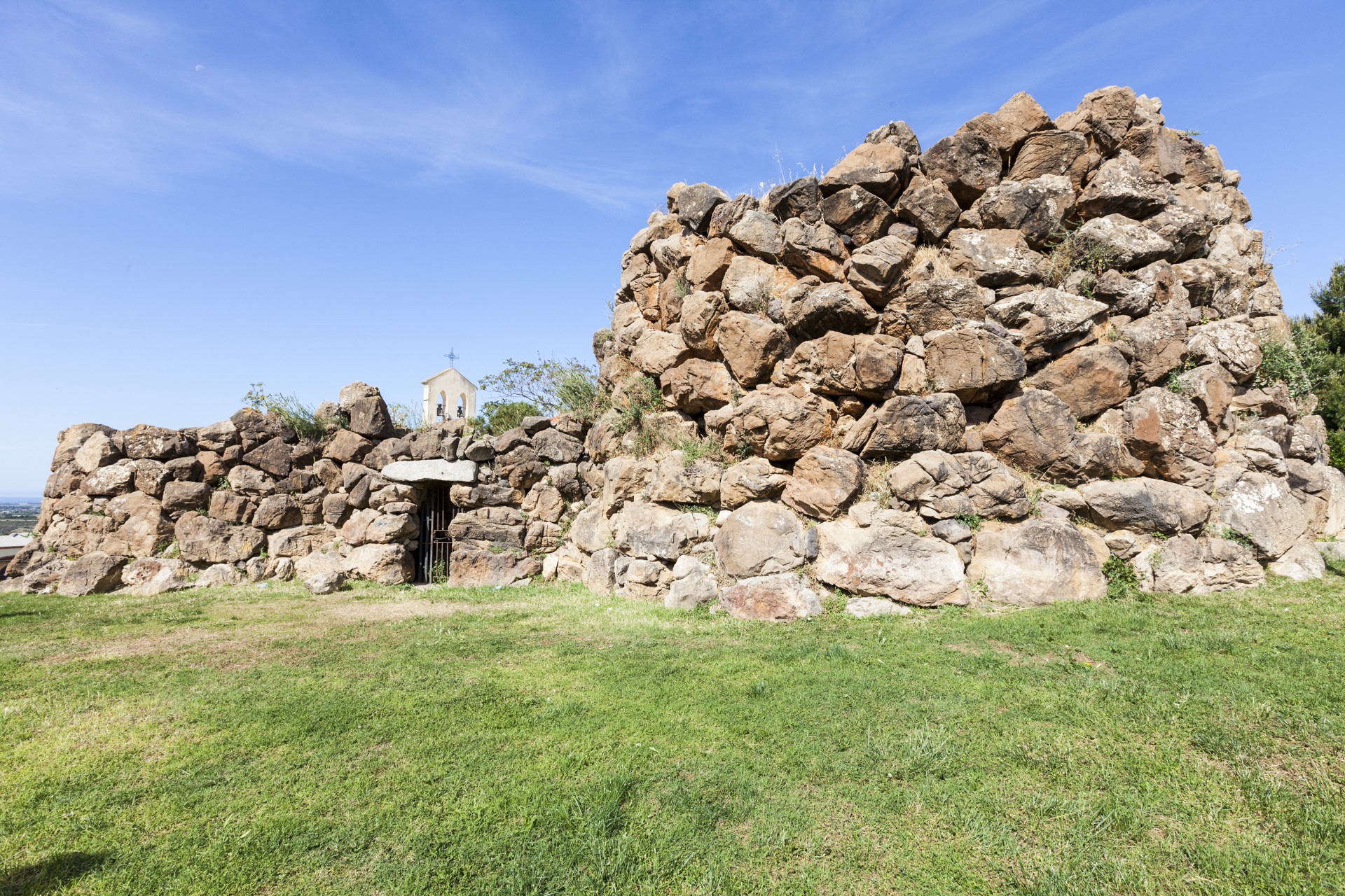
With a Neolithic site, one Nuraghe and two churches, this archaeological-artistic complex is enclosed in the space of a few tens of meters. Around the Nuraghe Arresi arose the first inhabited nucleus of Sant'Anna Arresi, a village in the lower Sulcis area whose name combines its prehistoric origin to the patron saint, to whom are dedicated ‘old’ and new parish. The Nuraghe, dating from the 15th-14th century BC (Middle Bronze Age), stands between the two churches and was built on an older settlement, inhabited in the late Neolithic and the early Aeneolithic periods (3200-2600 BC). Completing the prehistoric picture within the village are two Nuragic fountains, to the east and west of the monument. It is a case of cultural superimposition: various spiritual ‘forts’ came in succession within the town for millennia.
Arresi is a Nuraghe ‘a tancato’, which consists of a main tower connected to a secondary wall via two arms that close to form a courtyard. The building is made of limestone blocks arranged in rows with irregular ‘weaving’. The main tower (keep) has a diameter of about 13 metres and today is seven metres high today, whilst the secondary tower is smaller, having a diameter of four metres and a remaining height of two and a half metres. The entrance is in the arm of the eastern wall, surmounted by a granite architrave and leading into a hall in whose walls open up two small rooms. The corridor leads to the inner courtyard overlooked by the two towers. Inside the keep, travelling along a corridor, there is a small blind room and a narrow and steep staircase. Inside the main room are three niches arranged in a cross formation. In the secondary tower, there is a small room and an adjoining niche. No traces of a terrace or of the tholos roofing of the towers remain. The complex gives its name to the square in which it stands, Piazza del Nuraghe. It is here, at the beginning of September, that one of the most famous and long-lived Sardinian music festivals takes place, being Ai Confini Tra Sardegna e Jazz.
Other Nuragic structures and Tombs of Giants are scattered throughout the Sant'Anna territory. Along the road that leads to the beautiful Porto Pino - including four kilometres of fine white sand, surrounded by lagoons and pine forests - there is the Coi Casu complex, inhabited between the late and final Bronze age (17th-11th century BC). It consists of a Nuraghe complex with a village, around which emerge the ruins preserved by the lush Mediterranean vegetation. Amongst the various structures is a space for preserving food. Life returned to the settlement in the late Punic period (3rd-2nd century BC) until the Byzantine period (7th century AD).
Is Arenas
The name means ‘the sands’, or more specifically 'sand dunes' and they are among the most extensive in Italy. It is a small desert, where reforestation began in the 1950s, with pines and acacias, because the dunes risked expanding and turning the internal area into a desert. Today it has become a vast green area, where there is a pine forest and a golf course. Is Arenas (or Sas Renas) stretches for almost six kilometres: it is one of the longest beaches in the Oristano area, delimited to the north by the tip of Torre del Pozzo and to the south by a canal that links the sea and the pond of Is Benas. The central (and largest) part of the sandy shore is in the territory of Narbolia, while the southern part is in San Vero Milis and the northern part is in Cuglieri.
The beach has reddish-yellow sand with hints of gold, mixed with pebbles and shells on the water's edge. In some areas, you can admire pure white sand, like grains of rice, washed by the transparent water. Behind it, the landscape is dominated by the woods of Montiferru, while towards the sea you will see Capu Mannu, the northern tip of the Sinis peninsula and the protected area in which it is located.
It is often windswept by the strong northwesterly mistral wind and is, therefore, frequented all year long by windsurfing enthusiasts. Entering the water is not recommended in such conditions, while simply observing the sea will give you exciting sensations. The beach can be accessed by the disabled, it has ample parking and it is suitable for camper vans. There are also campsites, restaurants and bars.
The central stretch of the western coast, in the province of Oristano, is made up of beaches with fine sand or grains of quartz alternating with cliffs. Not to be missed, a little to the north of Is Arenas, is S'Archittu of Santa Caterina di Pittinurri (Cuglieri), one of the symbols of Sardinia, and also the beautiful beach of Putzu Idu. To the south, there is the Sinis peninsula, which boasts three absolutely beautiful pearls in the territory of Cabras: Mari Ermi, Maimoni and Is Arutas. Descending along the gulf, you will find the marina of Torregrande, the city beach of Oristano, and San Giovanni di Sinis, near the archaeological site of Tharros.
Spiaggia di Talmone
Talmone beach is in the Porto Cuncato locality. It is a cove framed by white limestone rocks and with amazingly clear water. This small sheltered cove has a crescent-shaped beach surrounded by shrub vegetation and offering jaw-dropping views.
On SS 133 in the direction Palau to Santa Teresa Gallura, take a side trail.
This beach has no amenities. Its crystal clear waters and beautiful sea floor make it a great place for snorkelling and diving. It is a quiet beach and does not get crowded.
Golfo Aranci
Situated at the base of the Capo Figari headland, Golfo Aranci overlooks the Gulf of Olbia and had always been an important port of call for goods since the beginning of the XX century. In 1961 the National Railways opened a ferry service for cars and passengers, which up till then had been Olbia's appanage. From then on the Golfo Aranci, Gallura's second gateway to the sea, started to develop its tourist profile thanks to the area's great beauty and to its proximity to the fashionable hotspots of the Costa Smeralda. The fishermen from Ponza who were attracted here by the richness of the sea bed and also the Gallura area's middle classes who spent their summers here, also contributed to its development as a tourist centre, together with an important historical research survey indicating that the area has been populated since Prehistoric times, confirmed by the presence of a sacred Nuraghic well at Milis. The actual name of Golfo Aranci, which long ago was known as Figari for the abundance of fig trees, derives from the presence of a beach called Sos Aranzos, one of the most beautiful in the Bay of Sassari, causing the derivation from "gulfu di li ranci" (gulf of crabs), as it was identified on maps, to be abandoned. Legend tells however, that the name comes from the wreck of a ship carrying a load of oranges.
From Golfo Aranci all the way to Olbia, low and regular coasts come one after another, characterised by little inlets and beaches of fine white sand most of which have tourist facilities. There are 24 beaches to be found in this area, all differing in size and easy to reach, some of which are situated in the village centre. One of the curious features of the village is the old fishing village which lies on the sea shore at the end of the inhabited centre and where you find coloured little houses and fishmongers' where you can buy good fresh fish all year round. Tourist structures and services are continually on the increase thanks to the hard work put in by the local council with the aim of making a stay in Golfo Aranci all the more pleasurable and easy, comprising among other things, the building of a tourist port. On Via Libertà, there is plenty of chance to do some shopping in the charming shops selling craftwork and typical local products, which liven up a walk around the centre in the summer months. The Parish Church of San Giuseppe, dedicated to the Patron Saint of the village attracts many curious visitors who wish to take a look at a number of marks on its wall that seem to resemble Padre Pio. The village offers all its tourists the chance to go trekking, to do water sports and go scuba diving in its crystal-clear water and for lovers of local cuisine, the chance to find excellent fish dishes in the local restaurants or to find fresh fish all year round.
Mangiabarche
White, time-worn, gently curving cliffs plunge into an intense blue sea. The beach of Mangiabarche is found on the island of Sant'Antioco, in the territory of Calasetta, not far from the town's three beaches: Le Saline, Sottotorre and Spiaggia Grande.
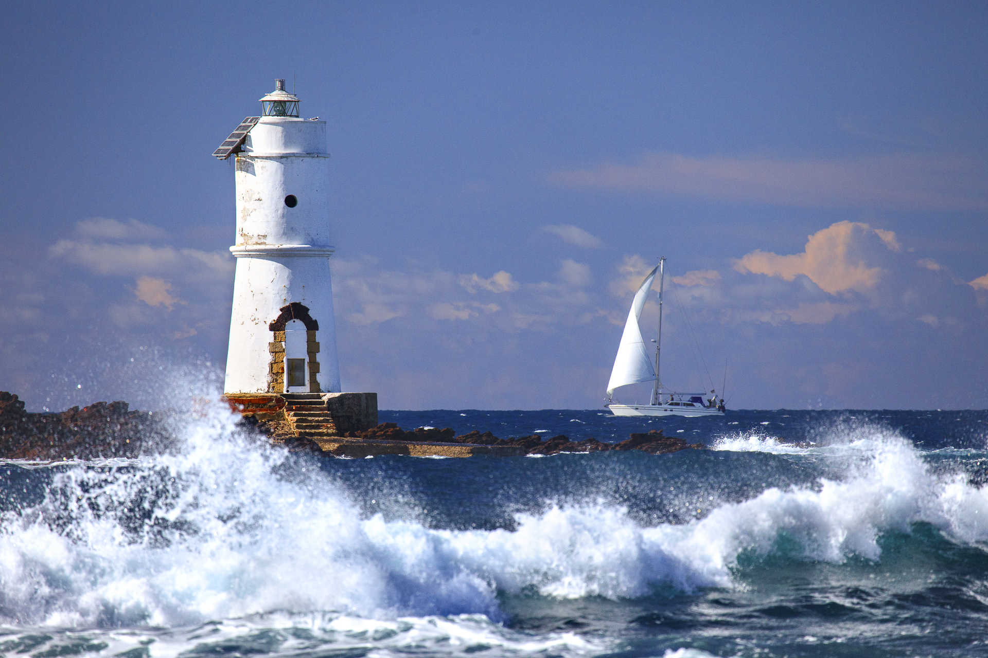
With only a small amount of sand, and crystal clear sea in the summer, this is a splendid place to dive or fish. In the winter, the waves become majestic. The jewel of Calasetta faces onto a rock, Punta Mangiabarche, topped by a small, solitary lighthouse placed to protect (sometimes unsuccessfully) boats from getting trapped on the semi-submerged rocks, which create a somewhat menacing fascination. In fact, the beach itself is named for its reputation as a danger to sailors and boats.
The reflections of the light on the water and the unusual landscape make it an obligatory stop for visitors to Sulcis all year round: visit the beach for a refreshing summer dip, or enjoy the enchanting panorama in the dark red light of an autumn sunset. During the winter storms at sea, huge, foamy waves explode against the lighthouse, showing off all the unforgettable power of the sea.
Close to the beach you'll find a small car park, bar, restaurant and hotel. Continuing along the western side of the island, you'll come across another pearl of the Calasetta territory: CalaLunga, an emerald green inlet that runs from open sea to a stretch of sand sheltered from the wind and currents of the sea, and surrounded by Mediterranean brush. In the part of the island in the territory of Sant’Antioco, the largest beach is Co’quaddus, while Is Praneddas is an amazing terrace over the sea, two hundred metres high and full of the colours and scents of aromatic plants. On the rocks of Capo Sperone, the southernmost tip of the island and a special wildlife reserve, you can spot the rare Eleonora's falcon and the peregrine falcon.