
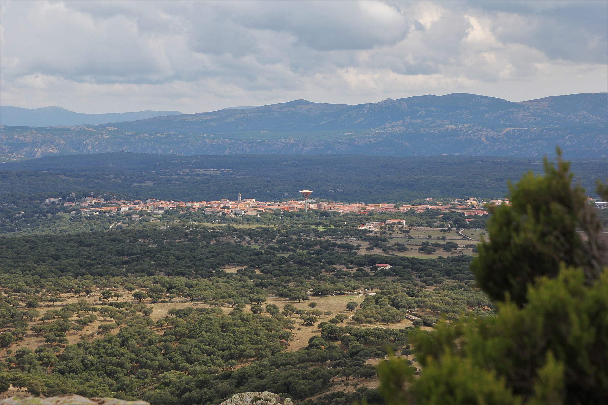
Alà dei Sardi
It is located at an altitude of almost 700 metres at the top of a plateau, next to the lush slopes of Mount Acuto, which gives a name to the territory to which the village belongs. Alà dei Sardi, a village with less than two thousand inhabitants, an enclave in the Logudoro area of Gallura, is part of a 'mosaic' made up of rugged, silent granite elevations with bizarre sculptures shaped by the wind, forests of holm oaks and oak trees, the kingdom of the mouflon and the eagle, staggering valleys with streams forming little lakes and the waterfalls of Su Fosslu Malu and flat dirt roads with stretches of Mediterranean scrub, where the trials for the Rally d'Italia Sardegna, a round of the world championship, takes place. From the village, you will see the Gulf of Olbia and the majestic outline of Tavolara and from the forest of Lithos, the mountains of Barbagia.
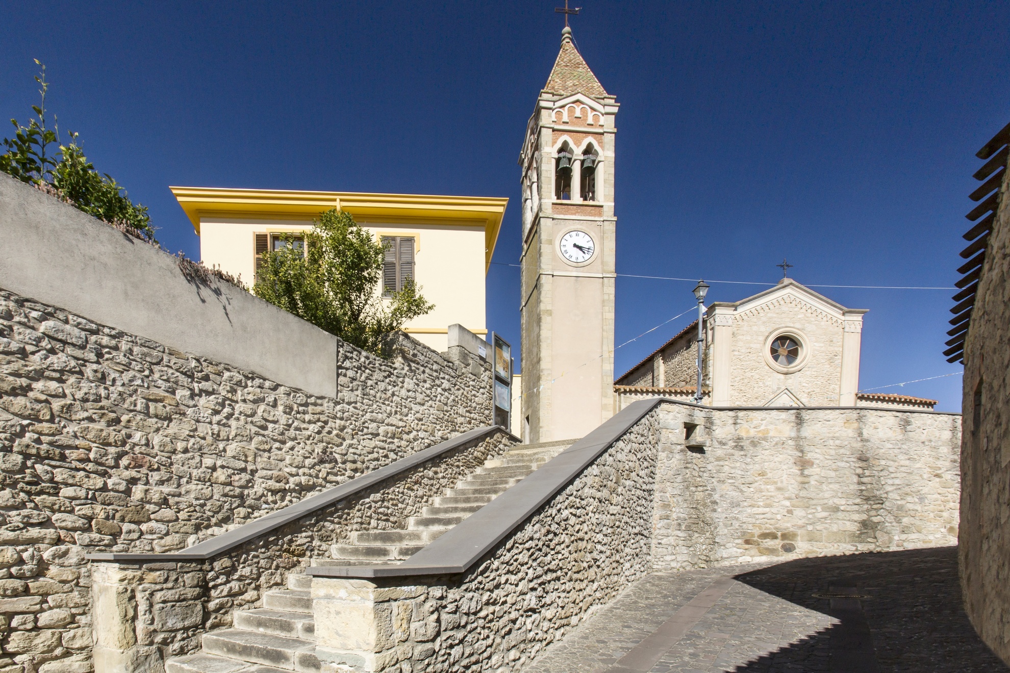
The first document to acknowledge Alà dates back to 1106. The name may have Paleo-Sardinian origins, linked to the Basque alha, meaning 'pasture', referring to the extensive pastures. Other possibilities may be the Latin ala - a roman army was stationed in the area - or the Punic word meaning 'placed high up'. The 'dei Sardi' specification was assigned by regal decree in 1864. The present-day village emerged in the 17th century around the Church of Santa Maria (1619), which was rebuilt between 1880 and 1961, becoming the parish church of Sant'Agostino. The façade is made of granite, enriched by statues of saints, while the majestic seventeenth-century mosaic of Our Lady of the Rosary is kept inside. The patron saint is celebrated at the end of August with religious celebrations and associated folk performances, where the splendid traditional costumes of Alà are on show, and the ham festival. The historical village centre is made up of houses and little buildings with 'austere' granite façades and wrought iron fixtures. In this setting, along the narrow streets, you will see unexpected granite architecture pop up: the wells of 'E Mesu Idda and S'Oltu Mannu, old town hall and small castle of the Dessena family. On the façade of Palazzo Corda (1850), 'the castle', a mural commemorates the last bardana (1870), meaning looting at the expense of the wealthy. Other churches in the centre are San Giovanni Battista and Sant'Antonio da Padova. Two kilometres from the village, in the Sanctuary of San Francesco d'Assisi, the origin of which is linked to legend, a celebration takes place early in October and attracts ten thousand worshippers. The processing of cork, granite and stones by the famous maistos of Alà is the main resource of a village undergoing considerable development since the year 2000, and boasts (with Buddusò) the largest wind farm in Italy. The centuries-old agricultural and pastoral tradition is still alive, with renowned products: beef and honey.
The territory was already inhabited in the Neolithic age. The greatest evidence is Nuragic: almost twenty sites, including towers, villages, tombs of Giants and sanctuaries. The main ones are Sos Nurattolos, dating back to the Iron Age, consisting of a sacred fountain, meeting hut, sanctuary and dwellings; the well-preserved nuraghe Boddò, and the village of Su Pedrighinosu, with circular buildings and a forge. The site was later inhabited by the Balares, a non-native rebellious people. Balare and Alà are phonetically similar and this is not a coincidence, if you consider that in the local dialect of Alà the 'b' at the beginning of a word is typically dropped.
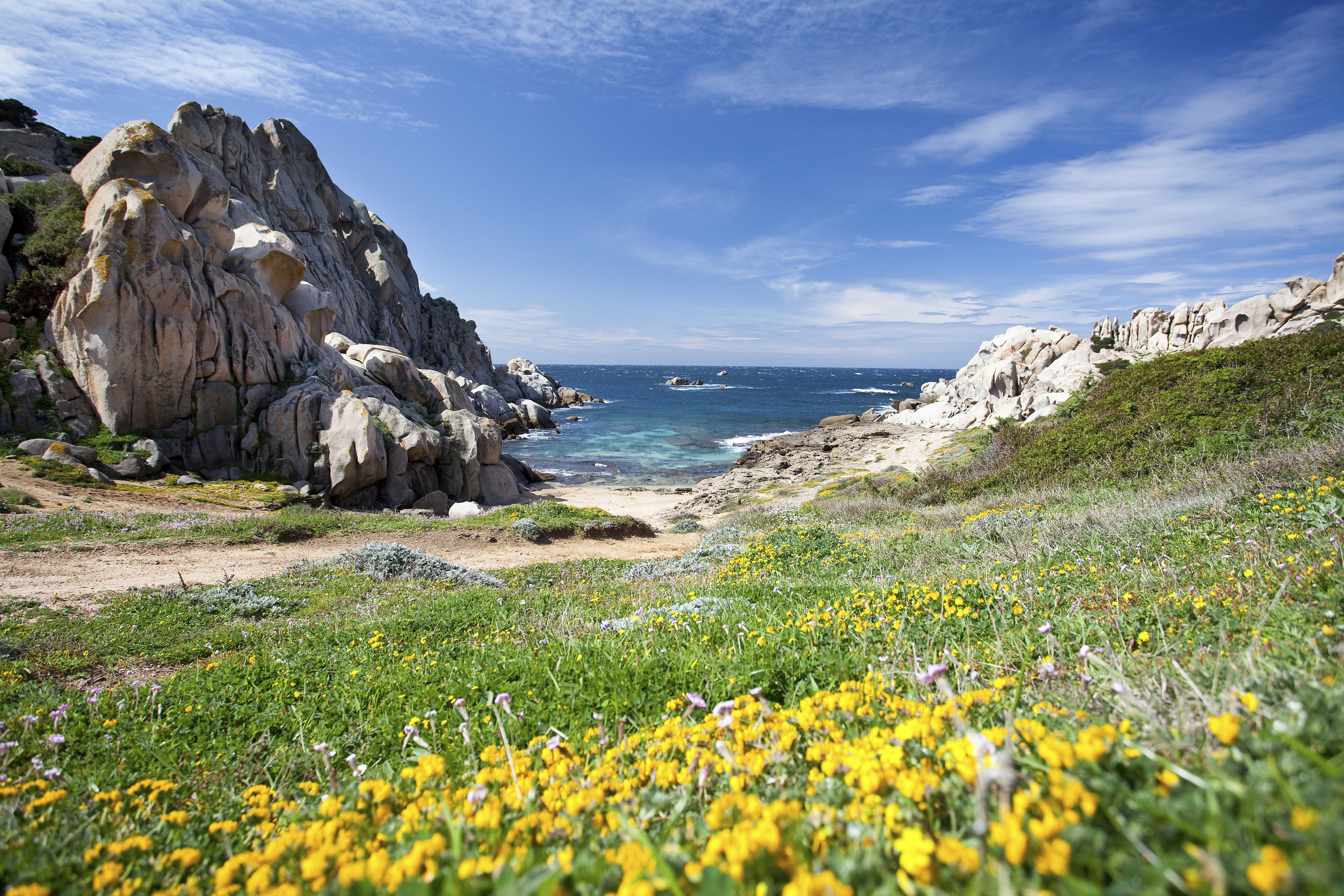
Cala Grande - Valle della Luna
A little valley, about 500 metres long, consisting of impressive granite rocks shaped by the force of the weather over thousands of years. Cala Grande (or Valle della Luna) is located in the western part of the promontory of Capo Testa, in the territory of Santa Teresa Gallura, approximately four kilometres from the residential area. You will see hidden little coves appear between the rock faces, with turquoise and crystal clear waters, made magical by the contrast with the golden colours of the rocks and the green of the dense Mediterranean scrub, in which there are strawberry trees, myrtle and heather.
Since the late 1960s, the promontory has been chosen as a home by a group of hippies and naturists, who have helped to keep it unspoilt. It was named Valle della Luna because of the unusual white colour of the rocks in the moonlight.A spectacular setting in which peace and nature rule, as in the other beautiful places in the valley: the coves ofl’Ea and Mezzu. Here, you can enjoy breathtaking, evocative landscapes, particularly popular with diving enthusiasts, which can be found everywhere during a visit to the whole area of the promontory.
Valle della Luna is one of the symbols of the long, splendid Santa Teresa Gallura strip of coastline, which offers you a myriad of must-see beaches: during your holiday, you can visit one or more per day. Starting with Capo Testa, which is joined to the mainland by a strip of sand forming Rena di Ponente (or Taltana) to the west and Rena di Levante to the east. Also near the peninsula-promontory, the little rocky coves of Santa Reparata are also worth visiting. A short distance from the old town centre of the renowned locality in the Gallura area, you can enjoy the dazzling colours and the transparent purity of Rena Bianca, a city beach of inestimable beauty. To the east of the residential area, you will find the picturesque Cala Sanbuco and the large and well-equipped La Marmorata. Continuing on in the direction of Palau, you will find the granite pools of Valle dell'Erica, Porto Liscia-Sciumara, the home of windsurf, and the captivating peace and quiet of the Conca Verde.

Aggius
In the heart of the Gallura is a characteristic village that will strike you for the great care they take of their granite houses, considered among the most beautiful in all the region. One of the main activities of those who live in Aggius is the extraction and processing of granite, but the town is also known for its beautiful carpets and, more generally speaking, for its fine textiles. The Touring Club Italiano has awarded the town with a Bandiera Arancione (Orange Flag) in recognition of the characteristics of the historical centre, the beauty of its setting and the efficiency of its services for visitors.
Among the attractions is the town’s choir, famous for its remarkable sound and nicknamed “Choir of the Galluran Roosters” by the famous poet Gabriele D’Annunzio. Another highlight is the atmosphere created during Holy Week, when the small town becomes something of a Jerusalem and the streets fill with the faithful as members of the local lay brotherhoods clad in traditional garments walk in solemn procession. Aggius is one of the few towns in Gallura to have maintained this centuries-old tradition and the entire week from Palm Sunday through Easter celebrations are held in spectacular Spanish tradition.
Do not miss a visit to the museo etnografico named after Oliva Carta Cannas, home to original items and machinery that tell of the history, culture and traditions of the Gallura region. Another unique museum focuses attention on the phenomenon of Bandits and is housed at the palazzo of the ‘vecchia Pretura.’
The vast area surrounding Aggius is ideal for hiking among the characteristic stazzi (characteristic rural settlements) and archaeological sites. The Izzana nuraghe, Gallura’s largest, is especially interesting.

Torre del Budello
The beach of Torre del Budello has dark sand mixed in with various grain gravel. Its name comes from the Spanish era look out tower of the same name. The Isola Rosso rises out of the sea in front of the beach, a rocky outcrop covered in typical Mediterranean brush vegetation

Valledoria
Seven kilometres of soft, golden sand, with dunes covered in sea lilies sprouting here and there, the mouth of a river that creates a little lake behind it and a crystal clear, blue and emerald green sea in front. The long sandy shore of the Valledoria coast is a succession of colourful, fragrant landscapes that you can experience in many ways: relaxing on the beach and swimming in the transparent sea, riding the waves on kiteboards and surfboards, or observing the wildlife that populates the mouth of the Coghinas river, while walking or on horseback, cycling or crossing the river by boat or in a kayak.
Between the river and the sea, the most interesting natural stretch of the Valledoria coastlines extends next to the special protection area known as the ‘mouth of Coghinas’. The beach is called Alta Bhanda and you can reach it aboard one of the boats departing from the area called Imbarcadero. You can watch spectacular sunsets, when the sun’s rays fill the sea, the dunes, the vegetation and the shores of the lake with bright colours. You can also reach the beach via a walk from the adjoining beach of San Pietro a mare. It is the most famous stretch of the coast and it gets its name from a small church near the parking areas.
In the surrounding area you will also find remains of the ancient town of Ampurias, a bishopric in the Middle Ages. The beach is made of soft-coloured sand with dunes on which there are sea lilies and Mediterranean scrub and, thanks to the surrounding greenery and the rays of sun on the water, the sea reflects shades of emerald green. Unlike Alta Bhanda, you’ll find services such as refreshment areas and beach equipment rentals here. It is one of the spots most popular with water sports enthusiasts.
Continuing west you will come across the small beaches of Baia Verde (Green Bay) and Baia dei Ginepri (Bay of Junipers): they get their name from the surrounding vegetation, where eucalyptus, mimosa and junipers stand out. In Baia Verde, a wooden walkway makes access easier for people with disabilities and reduced mobility. A cluster of rocks separates Baia dei Ginepri from the beach of Maragnani, the shore of which is delimited at the back by cream-coloured sandstone rocks. The waters are shallow and suitable for families with children. The remains of buildings dating back to the Roman era can be found in the area; other finds - including urns - were discovered in the waters in front of the neighbouring beach to the west, known by two names: Prima Guardia and La Ciaccia. The sea here has a vivid turquoise colour, with a few rocks emerging every so often, and it is ideal for snorkelling enthusiasts.
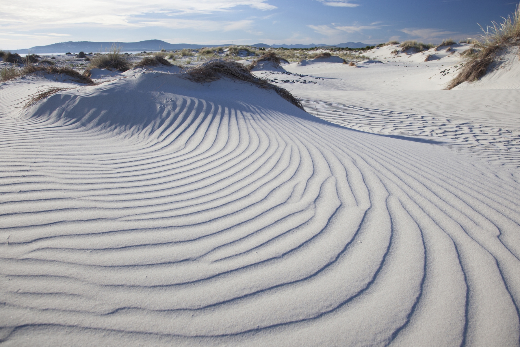
Le Dune
A dazzling one-kilometre long stretch of gentle, light sandy hills that reach a height of thirty metres. Between one and the other, as you walk towards the shore, you will see blue and turquoise brush strokes: the contrast between white sand and the colours of the sea will leave you breathless! The beach of Le Dune offers a dreamy landscape, with Mediterranean scrub that interrupts the whiteness with touches of fresh vegetation, while rosemary bushes give off their essence. This paradise, also known as Is Arenas Biancas, is the stretch of Porto Pino that is part of the territory of Teulada. Part of the coastline is only accessible in the summer, because it is located in the military firing range.
Overall, the beach of Porto Pino is almost four kilometres long: the long northern stretch (about three quarters of the total) of white sand dunes is part of Sant'Anna Arresi.
Close to the Le Dune beach, there is ample parking, which is also suitable for camper vans. On the sandy shore, there are bathing establishments, where you can rent beach equipment, and there are also places for dining and refreshments. A few kilometres away, there are accommodation facilities and restaurants. The water, cool and dominated by the currents, is accessible to all because the seabed slopes gently and it is also ideal for underwater fishing or snorkelling enthusiasts, as well as a destination for surfers throughout the year.
It is an oasis of incomparable beauty that will be one of your most precious memories: intense sunsets, the surrounding territory acting as a natural frame and long walks. In particular, behind the beach, where the pond of Is Brebeis is located, there is the summer home of numerous migratory birds: the greater flamingo, the kingfisher and the egret. The lagoon area then extends to the north with the ponds of Maestrale, Porto Pino, Il Corvo and Foxi.
Le Dune is one of the 'pearls' of Teulada, which can boast other dreamy beaches along its coast. Moving south, you will encounter, in order of appearance, Porto Zafferano, also part of the military area and only accessible via sea, in July and August, a beautiful and secluded place, the enchanting Porto Tramatzu, with its dazzling colours and shallow waters and, lastly, Tuerredda, simply a corner of the Caribbean in Sardinia, the symbolic beach of the Island.
Zerfaliu
It lies in the curadorìa of Campidano Maggiore, near the right bank of the Tirso, the longest river on the island that crosses the entire fertile and flourishing territory. Zerfaliu is a town of just over 1,000 inhabitants in the upper Oristano area, an important town for the cultivation of citrus fruits, to which the Sagra degli Agrumi (citrus fruit festival) has been dedicated since 1997, between February and March. In addition to oranges, tangerines, mandarins and grapefruits of a range of varieties, there is an exhibition of agricultural and food products and handicrafts, sweets recipes and marmalades based on citrus fruits and offering tastings of typical dishes. The area used for cultivations, for the orchard ‘gardens’, is a strip of land that separates the town from the river, Su Bennaxi, rendered particularly fertile thanks to the silt sediments following floods.
The other parts of the territory are Gregori, destined to the cultivation of cereals and pastures, and the evocative northern extremity, s'Ungroni, a valley dominated by oaks, Mediterranean maquis and the Nuraghe 'e Mesu, the largest and best preserved in all the land, a complex structure with two smaller towers flanked by a keep. Around its enclosure is a Nuragic well. Also noteworthy are the remains of the Nuragic structures Jana and Cagotti, close to the village. Not much remains of the Nuraghi Crabai, de su Strampu and San Giovanni. Tombs of Giant have been identified in Bau Craba and Serra Ebbruzzu. Roman presence is attested thanks to the discovery of a bronze disk with engravings from the 2nd century AD and, above all, by the small necropolis of Santu Giuanne, with tombs from the time of Emperor Hadrian. Nearby stands the church of San Giovanni Battista, whose original Romanesque layout dates back to the 13th century, perhaps made of material from the nearby Nuraghe San Giovanni. Built entirely in basalt and limestone, today it stands on the outskirts of the area. The first village arose around the historic Pisan church, dating back to the 11th century, of which there remains a pointed arch with an overlapping bell tower. The historic town centre consists of monumental buildings in basalt and trachyte and houses in raw brick, adorned within with wall frescoes, floors of coloured tiles and storage areas for supplies and for barrels of the local Vernaccia wine. Next to the Pisan arch stands the parish church of the Santissima Trasfigurazione, built under Spanish rule (15th-16th century) on the site of a prior church, before then undergoing various restorations until its reconstruction in 1947. Behind the altar is window dedicated to the Gesù Trasfigurato, the patron saint of the town, celebrated in early August. On the eve of the feast there is a long procession called s’Arrassignu. Greatly prized is the feast at the end of June in honour of San Giovanni, patron saint of shepherds, an event associated with the Sagra della Pecora (sheep festival), with opportunities to taste boiled sheep dishes and malloreddus. Other popular festivities are the feast of Sa Pio and s’Incontru at Easter.
Usellus
In a unique setting amongst the hills and mountains, between the parks of the Giara and Monte Arci and surrounded by luxuriant forests of oaks, stands a small town with a glorious past. Usellus is a quaint village of less than 800 inhabitants of the upper Marmilla. Its ancestor is Uselis, a town inhabited since the 8th century BC by people who traded with Phoenicians and the Punic populations of Tharros, then the colony Iulia Augusta from the 2nd century BC. It was an episcopal see for a millennium (from the 3rd to the 12th century) and capital of Curatoria in the Giudicato of Arborea. The Roman town controlled the passageways with the Barbaria and a crucial point when heading towards Aquae Napolitanae (Sardara), Forum Traiani (Fordongianus) and Neapolis (in Capo Frasca). The fundamental document attesting to the status of a colony is a bronze tablet of patronage from 158 AD, with the Usellenses being holders of the same rights and duties as citizens of Urbe. The geographer Tolomeo mentions Uselis as one of the only two Sardinian civium romanorum colonies (the other is Turris Lybissonis). Other Roman remnants are the bridge in the locality of Su Forraxi, a large number of brick tiles and the well-preserved network of roads. On the Roman ruins, on the hill of Donigala, arose the Chiesa di Santa Reparata, with three naves and a façade surmounted by a bell tower. Around the churchyard, the cumbessias have been preserved, being lodgings for the faithful used during novenas and festivals.
Abandoned in the 12th century, the town was rebuilt further downstream, in its current position. The historic town preserves numerous houses with lollas (porticos) open onto cobblestone courtyards that overlook the streets bearing imposing portals. At its heart stands the 17th-century parish church of San Bartolomeo, the patron saint celebrated at the end of August. Of late, an art exhibition has been inaugurated every year. Two kilometres from the town, in the pretty village of Escovedu, is the Chiesa di Sant’Antonio da Padova. Here, traditional architecture can also be admired, especially the 18th-century manor house of the Prinzis. Here also stands the communal winery, which produces excellent Malvasia, Monica and Vermentino varieties from the vineyards on the hills. From the olive groves comes a prestigious extra-virgin olive oil, whilst delicious cheeses, ricotta and meats come from the pastures. Skills and creativity are expressed in the processing of ceramics, iron, wood and stone, such as the tiles that complete the traditional mosaic of Usellus. There is also no lack of festivities, with the procession in honour of Sant’Isidoro held in mid-May, associated with the Sagra della Pecora (lamb food fair). In addition to Santa Reparata, another rural building of worship dates back to the time of the Vandals - the Chiesa di Santa Lucia, celebrated in early September with solemn rituals and a communal lunch in the s’Arroxiu wood. Near the church is the Tomb of Giants, Matrox’e Bois, flanked by the Nuragic complex of Santa Lucia, surrounded by cyclopean walls and the remains of huts. It is the largest of the nine Nuraghe in the territory. Mankind has been present in these area since the pre-Nuragic age, thanks to the strong drawcard of the obsidian, the ‘black gold’ of the Neolithic period, coming from the regional park of Mount Arci, of which 300 hectares belong to the Municipality of Usellus.
Fluminimaggiore
From the mountains to the sea, with natural monuments, evidence of prehistoric times and a Pheonician-Punic, Roman and industrial archaeological legacy. Fluminimaggiore is a municipality with three thousand inhabitants stretching along the valley of the Rio Mannu river. The river flows through the village and sets the blades of the Zurru Licheri mill into motion. The windmill dates back to 1750 and is currently an ethnographic museum where you can learn about local culture and history. The current municipality was established in 1704 when Viscount Asquer authorised the rebuilding of the village of Flumini Major, which had been uninhabited for a century. In the 19th century, the agricultural hamlet was converted into a centre supporting extraction activities: you will visit a place that symbolises Sardinian mining history with about thirty sites around it, bearing witness to a sudden and ephemeral development. The ghost village of the mine of Malacalzetta stands out.
The territory, which is full of forests, starts at the slopes of Mount Linas and descends towards the coast, with amazing landscapes. There are various coves along the coast: Guardia Is Turcus, Sa Perdixedda Manna and Sa Perdixedda Pittica ('the big and small stone') and the tourist district of Portixeddu, ten kilometres from the village. The long beach, which is cut in half by the outlet of the Rio Mannu river, has fine, ochre-coloured sand, is delimited by a cliff with natural pools and it is washed by a crystal clear sea. Five kilometres from the village you can explore the fairy-tale grottoes of Su Mannau, a Karst complex 'sculpted' 540 million years ago. It stands out due to its natural beauty and speleological and archaeological importance (one room was an underground temple). You can lose yourself in the magic resting under the surface, in the large rooms studded with huge limestone formations and unique shapes, stalactites, stalagmites, crystals and pools.
The grottoes were connected to the temple of Antas, one of Ancient Sardinia’s most important monuments, which you can reach via a path that had already been plotted by the Romans (four kilometres from Su Mannau). In a lush valley, you can admire a flight of steps covering three floors (there were originally more than three) and a podium decorated by elegant columns delimiting the votive areas. Created as a Nuragic sanctuary (9th century BC), it lived through the Carthaginian and Punic-Hellenistic periods. The temple reached its maximum splendour during the Roman era. The bronze statue of a divinity was found in a nearby tomb: perhaps the Sardus Pater or the Punic God Sid, the transposition of the local divinity Babai. In the summer, the Antas Music Festival takes place. As well as those in the temple, Pre-Nuragic, Nuragic, Phoenician-Punic, Roman and medieval artefacts from the territory are also on display in the archaeological museum. The paleontological museum is also worth visiting, where the marine Palaeozoic environment has been recreated. The most heartfelt events are the Fires of Sant'Antonio Abate (16 January), the Holy Week rituals and the festivals of Sant'Antonio da Padova (June) and Santa Maria Assunta (August).

Pinacoteca Nazionale
The Pinacoteca Nazionale (National Art Gallery) in Cagliari is a collection of ancient paintings, which was built starting in the 1800s.
It is located in the Cittadella dei Musei, a museum and cultural-academic complex that comprises the Archaeological Museum, the Art Gallery, Cagliari University's Department of Archaeology and History of Art and School of Sardinian Studies, the Regional Ethnographic Museum and the City Museum of Siamese Art (Cardu collection). This large museum complex was created on the site of the former Military Arsenal, on a design by Architects Piero Gazzola and Libero Cecchini, over a number of years starting in 1979.
The centrepiece of the Art Gallery is on display on the ground floor: a group of ancient Sardinian paintings, dated between the 15th and 16th centuries, mostly from the destroyed Church of San Francesco di Stampace. The paintings are by the Maestro di Castelsardo and Pietro Cavaro, the most prominent Sardinian painters of the late Gothic and early Renaissance periods. On the lower levels are 17th and 18th-century works, mainly by painters from the mainland.
A visit to Cagliari's Art Gallery is a chance to explore the work of the Catalan and Sardinian painters who made their mark on the island in the Aragonese period.
Address: Cittadella dei Musei, piazza Arsenale, 1 - 09124 Cagliari Phone +39 070 662496 Managing Agency: Ministry for Cultural Heritage and Activities