
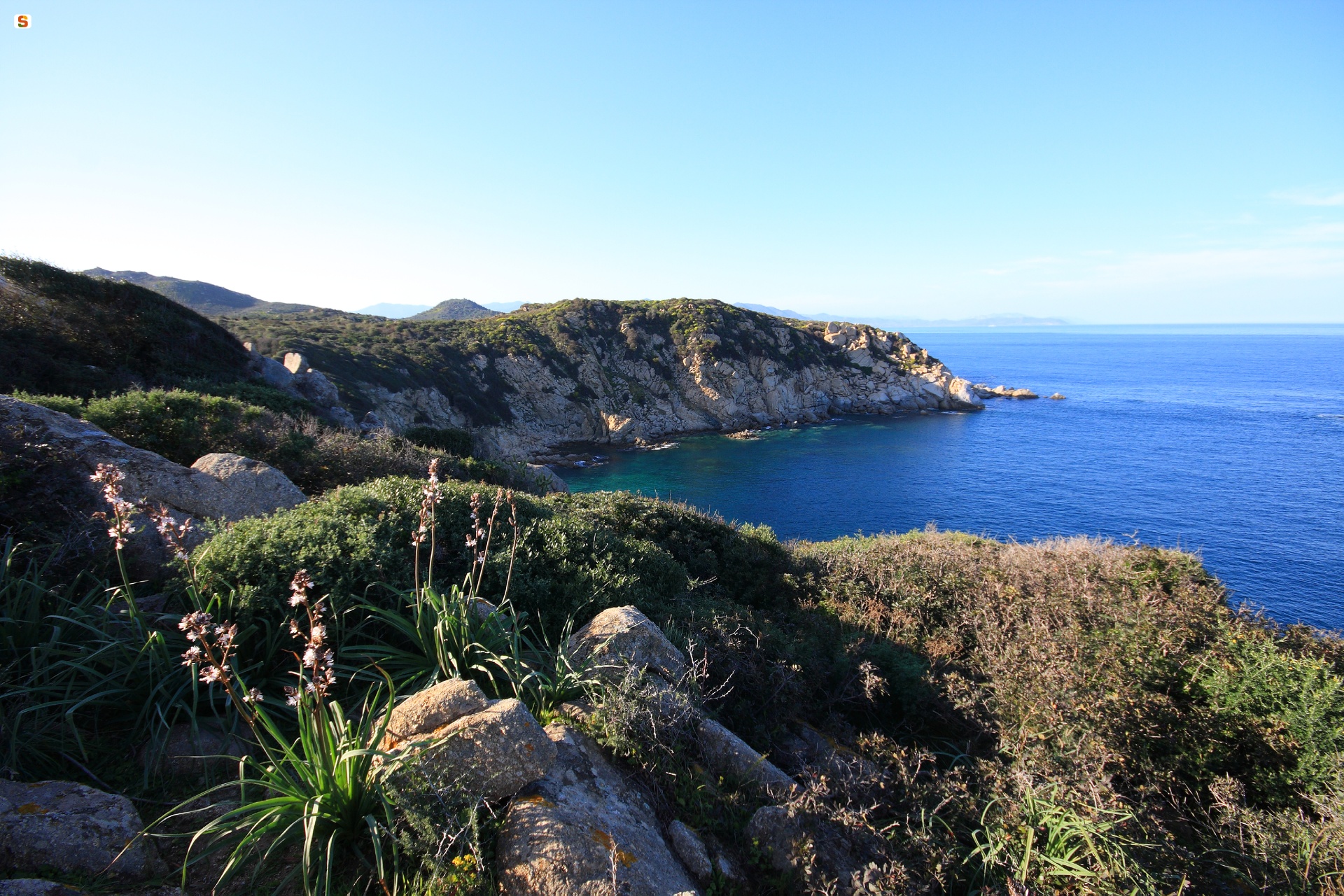
Cala Sa Figu
Those who go there to enjoy the sea in a bay surrounded by wild nature cannot resist the desire to explore the paths through the Mediterranean greenery and admire the view from the nearby promontory. Those who venture out along the paths that cross Capo Ferrato, riding a mountain bike or wearing trekking shoes, after seeing the beach, can’t resist stretching out on the sand and diving into the crystal clear waters. Cala sa Figu is the perfect combination of sea and nature. The crescent-shaped bay is located in the coastal area of Muravera, bordered by rocky cliffs covered in vegetation. The beach is made up of small grey and white grains of sand and, in the northern part, there are also pebbles. The sea is a deep blue colour, its waters are shallow and the seabed is sandy in the central part, becoming rocky on the sides, near the cliffs.
There are no services and sa Figu is the ideal beach for those who love little-frequented and unspoilt stretches of coastline with a primordial appearance. It is also known as the ‘bay of the amphorae’: the reason for this is the presence, in the stretch of sea in front of the beach, of numerous fragments of terracotta from ships that sank in the Roman era.
A strip of granite rock separates the beach from another cove, which is smaller but equally fascinating: Portu de s’Illixi, also nestled between the cliffs. In the northern part, beyond a mass of rocks, it ‘conceals’ a secret: another tiny cove, almost invisible until you enter the water. Speaking of surprises, along the stretch of cliff immediately east of Cala sa Figu, while on board a boat, you can admire a natural phenomenon dating back millions of years and only visible from the sea: columnar basalts generated by the volcanic activity of the nearby Monte Ferru.
The granite spur of Capo Ferrato is a destination for outdoor activities: the waters around the promontory are frequented by snorkelling and underwater fishing enthusiasts. Meanwhile, on the surface, there are trekking and mountain bike trails running in a ring towards the Capo Ferrato lighthouse and passing by the Spanish tower of Monte Ferru, built in the 17th century to oppose the threat of pirates. Both from the top of the volcanic cone and from the top of the promontory, you can admire a captivating landscape, allowing you to see the pool and the coast of Feraxi, while to the south you will have an extensive view of the long, white stretch of sand of Costa Rei.
Tula
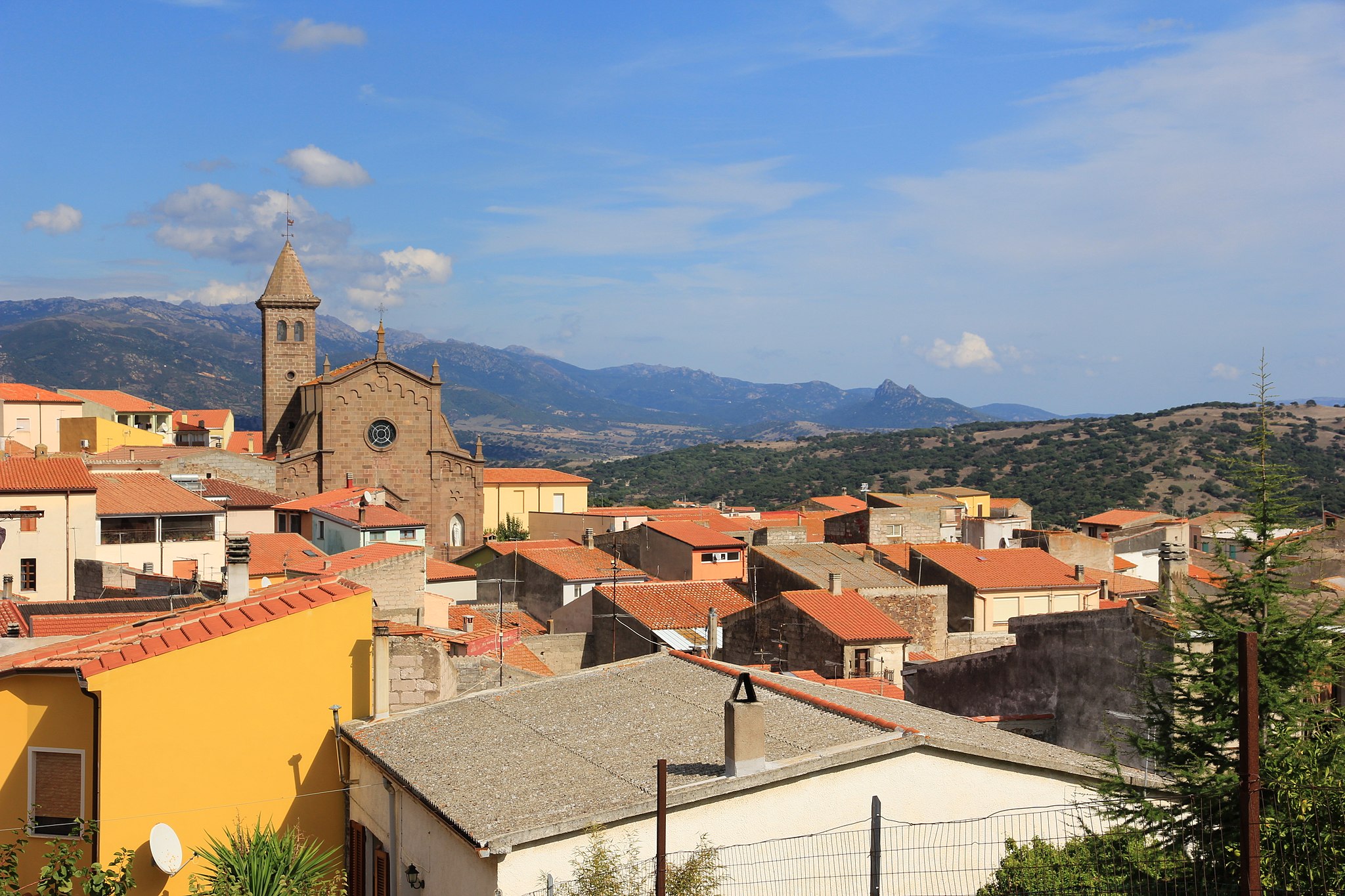
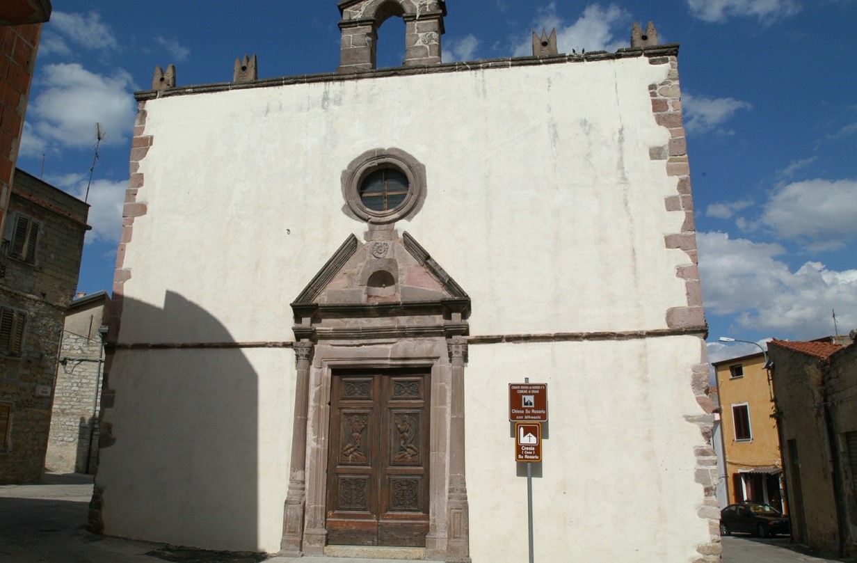
Tula stands at the base of the trachyte and calcareous plateau of Su Sassu, from which one can admire the Chilivani plain and the picturesque landscape of Lake Coghinas, having always been the protagonist of life in the town. Tula is a village of 1,600 inhabitants on the northern borders of Campo di Ozieri, intersecting precisely with three historical territories: Logudoro-Monteacuto, Anglona and Gallura. The oasis of Coghinas, the largest reservoir in the north of the island, is a great attraction. Here, nature and sport unite. The shores are lined with Mediterranean and tamarisk shrub, in its waters live trout, carp, perch, tench and eels. In the surrounds are valleys dotted with forests of oaks and cork trees extend farther than the eye can see. It is an ideal place for birdwatching, trekking and mountain bike enthusiasts. To experience Tula in a highly evocative way, there is canoeing and water skiing. A must held on the banks at the beginning of August is the Sagra della Carpa (Carp Festival), an opportunity to taste various seafood dishes. A wonderful view of the lake can also be enjoyed from the hamlet of Sa Sia - whose 50 residents speak Gallurese as opposed to the Logudorese dialect spoken throughout the country. It was here, at the beginning of the 20th century, that the Chiesa di San Pietro was built, in memory of that church of the same name was submerged during the construction of the reservoir.
The village, which survives on agropastoral and craft enterprises, has a quaint historic town centre with houses in tufa and locally-sourced stone, plus tall and majestic houses with portals of inlaid wood and wrought iron rosettes, as evidence of the historical evolution of the village. The oldest streets are narrow, the main one paved in granite. Here stands the parish church of Sant’Elena Imperatrice. Built in 1898 in the Pisan-Romanesque style, it houses a polyptych of the Holy Trinity. On the road to Perfugas is the Romanesque church of Nostra Signora di Coros, built in pink and grey trachyte in the first half of the 12th century. Of the original walls, erected next to a Tomb of Giants and the Nuraghe s’Arroccu, remain the lower rows of the apse.
The most ancient remnants in the territory date back to the Neolithic period, specifically the Domus de Janas, with a mushroom-shaped one to be found in Coloras. The most interesting site is Sa Mandra Manna, inhabited constantly from the Neolithic to Byzantine age. Here, a megalithic wall, a dolmen, a Corridor Nuraghe and other structures can be admired. During the Nuragic period, the territory was densely inhabited due to its enviable strategic position. Near the lake arise the Nuraghi Occultu, Mazzone, Sa Pigalva and Mannu. The discovery of coins confirms the presence of the Romans, attracted by the fertile lands. In the Middle Ages, the Villa di Tula was part of the Giudicato of Logudoro, before being acquired by the Doria family in the mid-13th century. The wedding between Eleonora d’Arborea and Brancaleone Doria (1376), saw it annexed to the Giudicato of Arborea.
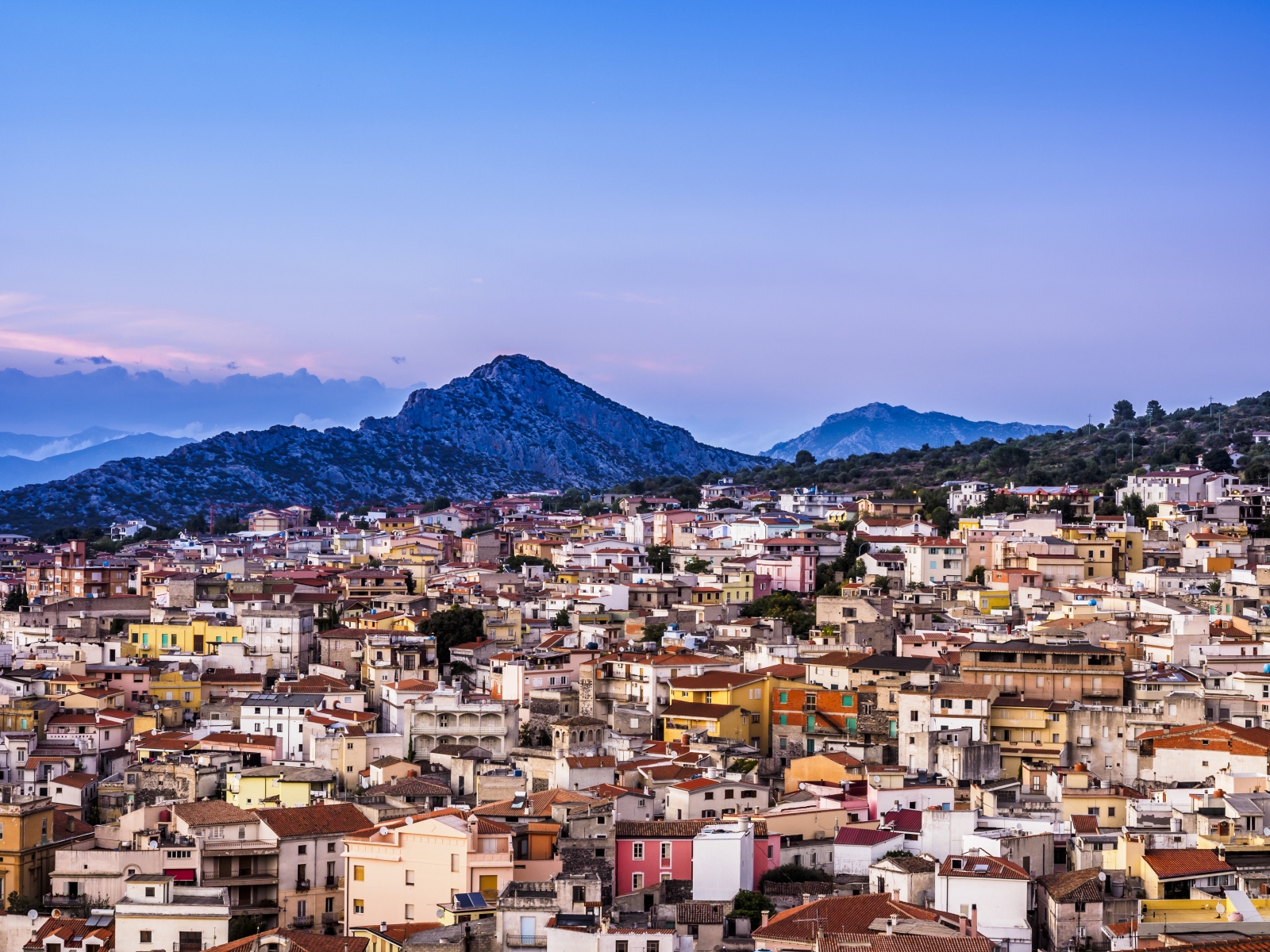
Fonni
“A fabulous horizon surrounds the village, the high mountains of Gennargentu, with luminous peaks that shine like silver, dominate the great valleys in the Barbagia, that rise, immense grey and green shells up to the crests where Fonni, with its flint houses and pebble alleys stand up to wind and lightning.” That is how the Nobel Prize author Grazia Deledda describes that what is now the largest town in the Barbagia di Ollolai (4,000 inhabitants) in her book Ashes (1903). The town sits at a thousand metres and is also a celebrated ski resort, thanks to the ski lifts that rise to the summits of Spada and Bruncu Spina (in excess of 1800 m). The snow falls thick in winter, the peaks turn white, while other seasons are graced with enchanting colours: peonies, gentian, rosehip and purple that surround the forest. It’s an area perfect for long hikes through woods and over brooks in nature reserves where rare species can be spotted along the trail. It is home to the Fonni Shepherd a breed of dog that specialises in protecting land and herds.
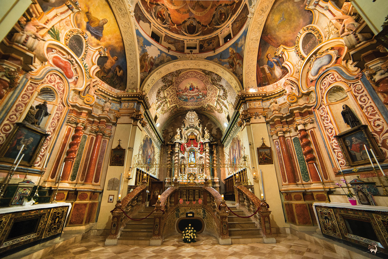
In the historic districts of town you’ll find mountain houses covered in scandulas, old wooden tiles, and admire the picturesque murals. During the Autumn in Barbagia festival make sure you visit the loggias and cantinas open to the public for the occasion. In the centre of town are the late-Gothic church of San Giovanni Battista, the basilica of the Vergine dei Martiri, surrounded by cumbessias and flanked by a Franciscan convent (1610) and the oratory of St, Michele (1760). It is enriched with frescoes, silver reliquaries and an underground sanctuary. Next door is the Museum of Pastoral Culture, set up in an 1800s residence. Here you can get an idea of what life was like in the country. Other churches in this devout and traditional town include del Rosario, Santa Croce and the Sanctuary of the Madonna del Monte. You will appreciate the delicious sweets produced here (called savoiardi), you will enjoy the Fonni Palio in early August and the Fonni Carnival festivities, featuring Urthos and Buttudos masks. The area’s archaeological gem is just outside of town, as you head to Pratobello, a Nuragic Age complex known as Gremanu. Set in a thick oak woods, it is the island’s only Nuragic aqueduct, associated with the Madau necropolis, made up of four Giant tombs with a shape resembling a bull’s head and horns. The settlement dates to between the XV and IX century BC and, further down towards the valley, has three temples (a large circular one, a megaron and a semicircular one) built with alternating basalt, limestone and trachyte to create pleasant chromatic effects. There are sacred enclosures, some one hundred huts and, further up, an articulated system to use the water from the springs for both sacred rites and daily use.

Villaputzu
Its ancient roads and stone houses match the shape of the mouth of the Flumendosa river. Villaputzu, a village with five thousand inhabitants, lies a short distance from the southeastern coast of the Island, along which there are stretches of sand and promontories with inlets. Four kilometres from the village, you will find the marvellous Porto Corallo and its modern tourist port, dominated by a tower, which is one of six making up the Aragonese defence system (16th century). Nearby, there is the captivating Porto Tramatzu: fine sand set in Mediterranean greenery. Further north, there is the beach of Quirra (or Murtas), which is only partly accessible due to military restrictions. Next to the coastline, alluvial plains with ponds open up and are the habitat of the western swamphen, the mallard and the greater flamingo. This unspoilt scenery combines sun and sea with birdwatching, biking and trekking. As you explore further, you will encounter dense woods: you can walk amidst the ruins of industrial archaeology, like the mine of Baccu Locci, and grottoes with intricate underground passages, stalactites and stalagmites.
Villaputzu's origins can be identified with Phoenician-Punic towns and the river port of Sarrapos (hence the name Sarrabus), dating back to the 7th century BC. It later became a Roman village, as is documented in the Itinerarium Antonini. The current village gravitates around the parish church of Santa Caterina of Alexandria. The Late Gothic church of San Giorgio Martire is also worth visiting. It was rebuilt in the 16th century on a previous 12th century structure. Among the rural churches, that of San Nicola stands out. It is a very rare example of a Sardinian Romanesque red brick building. The little church stands at the foot of the mountain of Castello di Quirra (13th century), places in which historical tales are told of sieges, along with legends about the Carroz family. The mountain has seven caves on different levels, where artefacts from the Palaeolithic era and from Roman and Medieval settlements have been found. There are infinite traces of prehistoric times in the territory: Domus de Janas necropolis of Torre Murtas and of S'Oru, underground interment of Casa Forrus, Pseudo-Nuraghi, single-tower and complex Nuraghi, Tombs of Giants and the sacred well of Is Pirois, built on the top of the Nuraghe.
The Fires of Sant'Antonio Abate, the carnival and the festivity of San Giorgio (in May) animate the village and the festival of the launeddas, in August, is the event par excellence: players from all over the island perform here. A similar concert, Canti di Canne, is staged on 26 December at San Giorgio. The musical instrument, consisting of three pipes played using the 'circular breathing' technique, has primordial native origins. Villaputzu boasts centuries of use of this instrument: skilled masters hand down this priceless heritage to young players. On the subject of traditions, you can admire fabrics, wicker baskets, wooden and ceramic objects in the summer, during the Sarrabus handicrafts exhibition. Citrus fruits stand out among the agricultural products. The exquisite cuisine is the result of ancient customs: culurgionis and malloreddus, char-grilled meat and fish and pastries like pardulas and pabassinas.

Talana
It is perched at an elevation of 700 metres. Surrounded by woods, it boats a view that spans from Gennargentu to the north-west, to the coast of Tortolì-Arbatax, 25 kilometres to the south-east. Talana is a town of just over 1000 inhabitants in the heart of the Ogliastra territory, the land of centenarians and ‘aging well’, thanks in part to an unpolluted environment, healthy lifestyle and good food. Uncontaminated nature and infinite scenic views are the town’s attractions: it is an ideal place for hiking along marked trails through thick woods and craggy steep, rocky slopes cut by hidden ravines eroded by water, where the more daring visitors can go canyoning through rapids and small waterfalls. Masses of pink granite extending almost 800 meters up the slopes of Mount Mundugia, with its curious trapezoidal shape and impressive gradient, are worth a look.
The town name has Pre-Roman origins, tracing to Thalna (or Thalana), an Etruscan divinity, or to Tàlara (later Tàlana), used to refer to ‘mountainous areas’. A typical mountain town, it perches on some hillocks truncating the steep ridges below the Forest of Funtana ‘e Filigi, which re-emerge further down and continue to the Valley of Coa ‘e Serra. Talana has retained its original layout: narrow, winding alleys linked by frequent stairways and lined with multi-storey houses, some built using grey granite. The network of streets converges at the Parish of Santa Marta. Constructed in early 19th century, it houses 16th century wooden statues. The church is the site of two festivals: the one in late July is called Santa Marta Piccola (little Saint Marta), and the one in early September, Santa Marta Manna (big Saint Marta). In late September, the town celebrates Saint Michele. The church dedicated to him is now gone, but there is a social-cultural centre bearing his name. On the first Sunday in May, a statue of Saint Efisio is carried in a procession to the small country church dedicated to him.
Tradition recipes are based on culurgiones, roasted meat and cheeses. Excellent products arrive from olive groves, vineyards and pastures: olive oil, cannonau and prosciutto, which visitors have the opportunity to taste at the Regional Show/Market of Prosciutto, held in late July/early August. To learn about local crafts, there is the Arti Antiga exhibition. Set up at the house museum in Via Cavour, it includes textile, wrought iron and pottery items, which explore ancient uses and traditions. The area’s wealth of springs and fountains - Gillaoro, s’Orgoese, Sa Carrera and Funtana ‘e Idda in the town alone – has drawn people as far back as Pre-Nuragic times, as seen from the Domus de Janas of Silla Caccari. The area was densely populated during the Nuragic Era: 70 settlements have been found, often on rocky protrusions. The best examples are the village of Praidas at an elevation of over 100 metres and nuraghes of Bau ‘e Tanca and the well-preserved and mysterious s’Arcu ‘e s’Apiargiu (o Lotzorei).
Dorgali
The history, manufacturing arts, the sea, the wild mountains and fragrant woods of the Supramonte will take you to a magical and legendary world. In Dorgali, you will visit an enviable natural patrimony of 225 square kilometres, one of the most extensive municipal territories in Sardinia.
Walking through its distinctive streets, you will see houses made of dark volcanic rock and workshops, where filigree jewellery, pottery and carpet weaving will allow you to discover the village's artisan calling. You can visit the churches of San Lussurio, Madonna d'Itria and the parish church of Santa Caterina. You will travel back in time while in the archaeological museum, which contains artefacts from the Nuragic age (also those of the nearby site of Serra Òrrios) and from the Punic and Roman periods. A few kilometres from the residential area, you can take a trip to the Lanaittu valley and to the legendary Village of Tiscali.
Not far outside the village, in the opposite direction, after passing through a short tunnel, you will see the splendid sightof the Gulf of Orosei, like a real gateway between mountain and sea. Here, you will see true gems like Cala Gonone, Cala Cartoe, Ziu Martine and Cala Osalla, all beaches with golden sand. By boat, or a strenuous hike, you can reach Cala Luna, which borders on Baunei, one of the Mediterranean’s most enchanting beaches. Graced with a beach of almost powdery sand and surrounded by blooming oleander trees it was the setting for the Lina Wertmüller cult film Swept Away. Further inland is the Codula di Luna, a deep gorge of steep walls and ancient juniper trees that have always acted as guardians of the beauty of this place.
Dorgali is famous for the Bue Marino Grottoes, a spectacular 'forest' of stalactites and stalagmites in which there is an underwater saltwater lake and where, during the Cala Gonone Jazz event, one of the most spectacular concerts taking place in Sardinia is celebrated every year. On the subject of marine discoveries, don't miss a chance to visit the Aquarium of Cala Gonone: 25 pools with numerous rare species, particularly loved by children and youngsters.

Tramatzu
The beach of Tramatzu has fine, light-coloured sand. It is surrounded by rocks. The name refers to the typical flora of the Mediterranean brush: ‘tramatzu’ means ‘tamarisk’ ,a plant similar to the cypress tree.
Flussio
The town of Flussio runs into Tinnùra, with which it shares a main street that crosses through both towns (ss292). Flussio is a small town with less than 500 inhabitants in the Planargia, which sits on a gentle slope between the lower valley of the Temo river valley and a basaltic spur known as Pedra Senta. It’s a fertile land specialized in asphodelus plants which, when dried, are the raw material used to make elaborate woven baskets known as corbule, and other containers, and the reason why Flussio is famous first and foremost for its weaving, an art handed down over generations and still today practiced by the town’s womenfolk. In April you’ll be able to enjoy the re-enactment of the rituals of harvest during the shared festival called Tirende isciareu, or “gathering the asphodelus.” Don’t miss a chance to walk through town right after the harvest, when the plants are left to dry in bundles in courtyards, on streets and piazzas, covering every square inch of the town, and to listen to stories about how the baskets are woven. To learn more about this ancient tradition, visit the museo dell’Asfodelo. Items are also made using reed, willow, elm and olive branches. Malvasia grapes are the other main product of Flussio. The Planargia wine cooperative, located in town, makes a very pleasant wine and has earned the DOC denomination. They also make sparkling wine and grappa. Flussio belongs to the Strada del vino malvasia di Bosa wine road.
The area was first inhabited in prehistoric times, as proven by numerous Bronze Age constructions like the Giannas, Murciu, Caddàris and Carcheras nuraghes, the sos Trainos and sa Figu Bianca Giant Tombs, and the megalithic wall, which appears to date to the Nuragic Era, near the parish church of San Bartolomeo. This church was built in the XII century and is now part of a larger and more modern structure. Legend has it that San Bartolomeo himself taught the inhabitants of Flussio to weave. In the late 1800s stone weapons, the remains of a tomb and the ruins of a Roman building were brought to light. It may well have been a fortified settlement.
Celebrations in Flussio include 16 January when bonfires are lit in honour of sant’Antonio Abate, in August when their patron saint is honoured with a procession from the church of Santa Maria della Neve along the towns streets, and the festivities surrounding saints Bartolomeo and Costantino, featuring a picturesque procession on horseback. In mid-December they celebrate Santa Lucia and hold the su binu nou festival to celebrate the new wine.

Cala Fuili
This wonder is worthy of a film and, in fact, appears on the set of ‘Swept Away’ (1974) with Mariangela Melato and Giancarlo Giannini. It is the last cove that can be reached by car or by bike from the renowned tourist location of Cala Gonone, because the road ends at the point in which a descent towards the beach begins. The small, unspoilt, panoramic Cala Fuili, in the territory of Dorgali, not far from the Grotte del Bue Marino, will amaze you with its shallow, incredibly transparent waters and sea with colours ranging from green to turquoise.
Once you have gone down the steps carved out of the rock and crossed a dense wood of shrubs of Mediterranean scrub, the beach, with its white sand mixed with pebbles and rocks emerging from the sea, appears before you.
Your walk will be rewarded by the scenery: the contrast between the green vegetation and the blue sea contributes to the fairy-tale setting of this little cove, along with the rock faces that attract numerous climbing enthusiasts every year. It is very popular with trekking and canyoning lovers –it can also be reached via the evocative internal trail of Codula Fuili - as well as with diving and snorkelling enthusiasts.
Further south, along the Gulf of Orosei, you will find other havens with unspoilt nature and crystal clear waters: Cala Luna and, in the territory of Baunei, Cala Biriola, Cala Sisine, Cala Mariolu and Cala Goloritzè, which will offer you landscapes that warm the heart.
If you are interested in the civilizations of the past, in this area you will be able to go on a journey back in time and visit nuraghi, menhir, dolmen and domus de Janas, or you can delve into the evocative atmosphere of the Nuragic villageof Tiscali. You can also visit the Grotta di Ispinigoli, featuring a 38-metre stalagmitic column, the highest in Europe.