
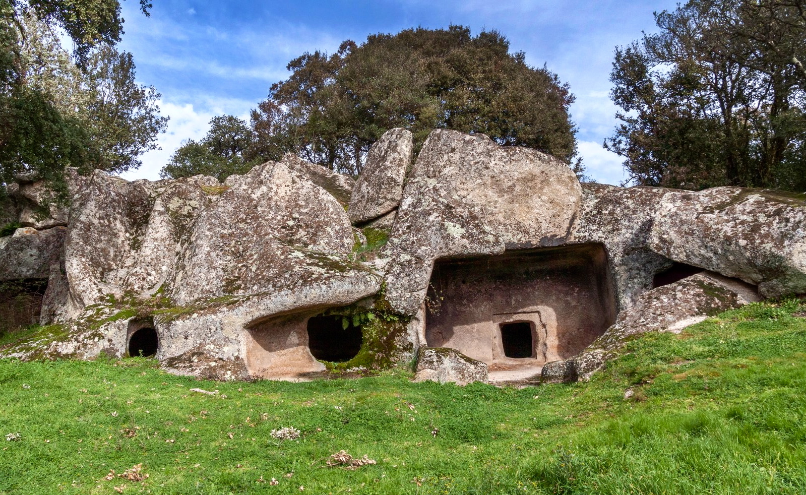
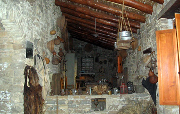
Necropoli di Ludurru
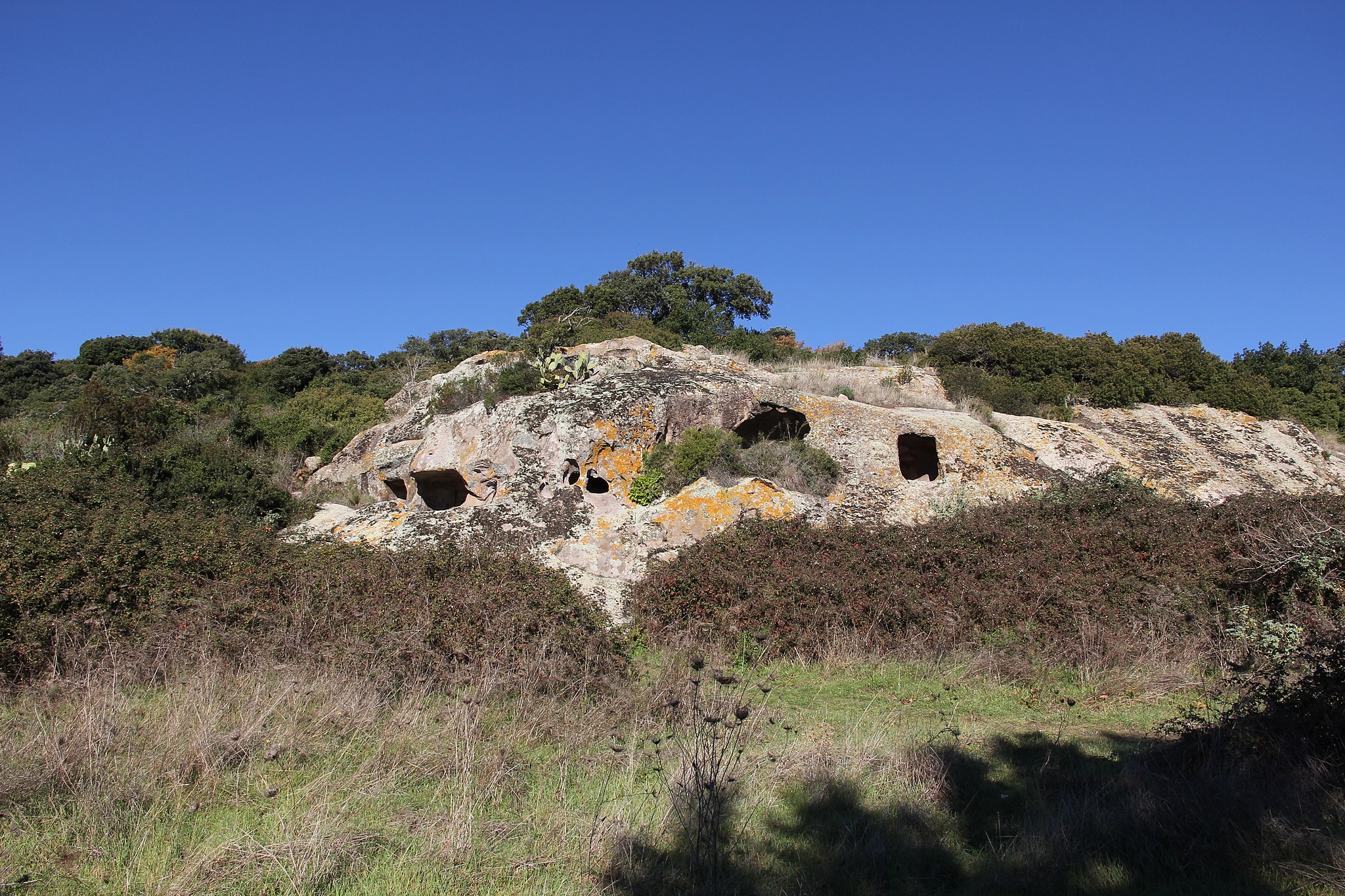
Since the Neolithic period, the people who inhabited the area of Buddusò used one of its most distinctive natural resources, granite. The precious stone was not only present in everyday life. In fact, worship and relative rituals dedicated to deceased loved ones required their remains to be conserved in hypogea dug out of the very hard rock, involving huge efforts. One of these granite benches used for the cult of the dead is in the locality of Ludurru, a few hundred metres from the inhabited area of the ‘granite’ village, which today represents a crossroads between the historical territories of Gallura, Monte Acuto, Goceano, Baronìa and upper Barbagia. Here, surrounded by Phillyrea shrubs and cork oaks, lies a domus de Janas necropolis, consisting of six ‘fairy houses’, hypogea dug during the Final Neolithic period (3200-2800 BC).
The tombs have one or more rooms. Tomb 1 has a pavilion with a hatch that leads into the anteroom, where you will notice, along the perimeter of the floor and ceiling, bands carved in relief that frame the walls and drainage channels on the floor. Two entrances with painted red bands above them lead to the central room, from which two secondary rooms branch off. Tombs 2 and 3 are single-celled and the third hypogeum in particular has a semicircular niche. The fourth domus is divided into three rooms preceded by an anteroom, in which one corner is occupied by a rectangular counter and, in the centre of the floor, a cupule was created for the hearth or in which votive objects would be placed. In the main cell, there is a trace of two semi-columns. Hypogea 5 and 6 are similar, made up of a pavilion that leads into a semicircular space. Outside, you can see a ‘roof’ covering an entrance to the tombs, while on the left of the necropolis, a false door was carved on a boulder covered with lichens, symbolising the entrance to the realm of the afterlife. Lastly, on the top of the granite outcrop, you will notice an almost regular parallelepiped-shaped boulder, with a hollow similar to a channel and a basin: the most probable theory is that it was an altar.
Buddusò contains numerous other prehistoric remains. In all, about 60 domus de Janas have been found, one of which is within the village, while most of them are in the necropolis and in its countryside: in addition to Ludurru, the burial sites of Borucca also stand out. The Bronze Age is documented by 32 nuraghi. The most important is located along the road that leads to Bitti: it is the nuraghe Loelle, hidden in the woods and featuring a ‘mixed’ structure, partly protonuraghe and partly a complex structure. Next to it, there is a village of huts, two Tombs of Giants and a dolmen.
Is Mortorius
The beach of Is Mortorius is found in the locality of the same name, in the municipal area of Quartu Sant'Elena. The seashore is made up of various sized grains of gravel, from sand to rock. Its waters are of a changing blue due to the plays of light created by the sun reflected on the seabed of stones. A strip of rock stretches out, smoothed by the sea, and inhabited by typical fauna of limpets and sea urchins. Nearby, are the two bays of Baia Azzurra, hemmed in by vegetation and bluffs.


Isola Piana
A jewel set into the blue of the sea, full of fascinating legends.Piana island is part of the Sulcis archipelago and falls under the territory of Carloforte. Over the centuries it has welcomed communities of monks, it was a penal colony, the historical centre of tuna fishing and a noble holding. Today it hosts a prestigious tourism residence with 200 homes: access is reserved for the owners and their guests.
To reach the island, which has a marina for pleasure boats, you will need to cross a short strip of sea from Calasetta, Carloforte or Portoscuso. You can swim, but not enter. On the island there are no cars, motorcycles or bicycles: it is a nature reserve, and any kind of noise or environmental pollution could disturb the Eleonora's falcon, royal gull and plovers that nest here. However, the island is small and easy to cross on foot, in contact with the untouched nature and clear sea, where you can sail or fish. It is an ecological oasis: completely self-sufficient in terms of water and electricity, with energy saving technology, and no waste water discharging into the sea: the water is purified and recycled for watering the gardens and vegetable gardens bordered by palms and Mediterranean brush.
The history of Piana is tied to that of tuna fishing. In the late 17th century, the King of Sardinia granted the licence for tuna fishing and processing to Don Francesco Pes, who was raised to marquis in 1774. The island was made a holding and assigned to the Villamarina family: the marquis and his family lived alongside the tuna fishers, who inhabited a village near the fishing vessel during the work. In 1898, Marquis Salvatore Pes began activities again with advanced equipment, and rebuilt the homes. In 1964, activities ceased and the village lay abandoned until 1975. The luxury resort was created with 160 homes for the island's owners and other homes within the residence. The rite of the tuna slaughter, however continues. Every year in May and June the tuna fishing vessel is launched: the catch is processed in the island of San Pietro. There is one particular tradition on the island: diving off the pier to say goodbye to a friend. Not so much a goodbye as an arriverderci - until we meet again. While you're waiting to go back, don't miss the chance to see all the other attractions of the Sulcis archipelago, especially the coastal beauties of the two largest islands: Sant’Antioco and San Pietro.
Cala Sisine
It is perhaps less well-known thanother coves in the Gulf of Orosei - Luna, Goloritzè and Mariolu - but it will nevertheless make your holiday a dream, thanks to the blue sea and a seabed of round, white pebbles. Cala Sisine is located at the end of a codula, which is a gully, once a riverbed and now the mouth of a small torrent, which originates on the plateau of Golgo,in the Supramontedi Baunei area.
Approximately 200 metres wide, it looks out onto the cliffs of Serra Ovra that stand over 500 metres high and overlook the sea. It is bordered, almost enshrouded, by rocky crags, while the gorge is covered by the greenery of centuries-old carob trees and holm oaks. Quite ironically, although it is one of the most beautiful seaside localities of all, it has a unique mountainous appearance. The waters are a shimmering turquoise colour due to the play of sunlight reflected upon it. The seabed consists of light grains of limestone sand and rounded stones, the ideal setting if you want to take your mask and do some snorkelling.
To the south, there is a spectacular cove, fifty metres high and a trampoline for the bravest and most expert divers. You can get to the cove in private boats or using services departing from the ports of Arbatax,Cala Gonone and Santa Maria Navarrese. It can also be reached on foot, but with greater difficulty, along marked-out trekking trails. If you want a little refreshment after your walk, there are bars and places for dining/refreshments.
In ancient times, it was known as Portu ‘e Sisine, a landing place for cargos of coal. In fact, to the north there is still a building constructed by the carbon merchants. Tools have been found in the area,revealing the presence of humans here about 4000 years ago. In past centuries, stopping here was a must, after having crossed the terrible monti insani, meaning insane mountains (which is where the name Monte Santo comes from), as Cicero defined them. The oldest inhabitants tell us that, to the south of the beach, during the Second World War, a submarine stopped in a sheltered area known as Su Stuggiu (the hiding place). During your trip along the gulf, in the Baunei territory, don't miss an opportunity to stretch out on the (more) famous and equally charming coves of Biriola, Goloritzèand Mariolu.

Maladroxia
A natural paradise, suitable for families, couples or a relaxing solo break. The beautiful beach of Maladroxia is one of the jewels of Sant’Antioco, about nine kilometres from the centre of the main town on the island. It is characterised by a long and undulating sandy beach of about 500 meters of soft, fine and soft sand mixed with sections of pebbles, plunging into the limpid and crystalline water of a sea with colours ranging from emerald green to turquoise. The seabed is low near the shoreline and gently sloping; just a little further out, you will come across dry dunes of posidonia, on which you can walk. The frequent winds make it an ideal destination for surfers and it is loved by scuba-diving enthusiasts. The beach is surrounded by Mediterranean greenery, and backed by the small village of Maladroxia, a tourist resort with private villas, holiday homes and hotels, restaurants and pizzerias, kiosks and bars. The wide range of services complete the picture: ample parking, buses, and rental services for bathing equipment, pedal boats, canoes and rafts. The village is dominated by a hill surmounted by the s'Ega de Marteddu nuraghe.
Maladroxia stretches in front of the Golfo di Palmas, on the south-eastern side of the Island of Sant’Antioco, the largest minor island of Sardinia, whose territory is divided between the towns of Calasetta and Sant'Antioco. The coastline has high jagged cliffs to the south and lower shores to the north. Portixeddu is the nearest beach to the village, and is made of pebbles, like the nearby and larger Turri beach. Another sandy stretch in the territory of Sant'Antioco is the long and sinuous beach of Coacuaddus, divided into two parts by a large rock and bordered by limestone cliffs. Do not miss the cliffs of is Praneddas (or arco 'dei Baci'), where you can stand on a terrace, 200 meters above the sea, to admire the whitewashed rocks of Cala Sapone and Cala Grotta and Cala della Signora . Capo Sperone is the extreme southern tip, in front of which rise the islets of Vacca and Toro, natural havens inhabited by rare birds.
The town is characterised by colourful houses, amazing restaurants and a tourist port, which give it a strong seafaring identity. Once it was known as Sulky, a Phoenician colony born in 770 BC, which later passed under the Carthaginian rule and became a flourishing Roman city with the name of Sulci. Don't miss a visit to the sanctuary of Sant'Antioco Martire, patron saint of Sardinia, and to the Ferruccio Barreca archaeological museum which contains Phoenician-Punic finds.
Cala Napoletana
Its sea is so transparent that the boats parked offshore seem to be floating in the air. If it weren't for the numerous, multicoloured fish crowding the seabed, the waters of Cala Napoletana would be identical to those of a swimming pool. The surrounding landscape, on the other hand, makes you think of an earthly paradise: fine, soft, white sand, granite rocks tinged with pink and sinuous shapes, patiently smoothed by the wind and waves, and lush, green bushes in the Mediterranean scrub surrounding the small cove.
In reality, the sandy shore is divided into three beaches, separated by rocks and large granite boulders. The water is shallow and the gently sloping, sandy seabed is perfect for snorkelling, thanks to the extraordinarily transparent water. For those who want to relax and admire the view, the central hours of the day are best, when the sun’s rays highlight the natural colours of the beach with magical plays of light.
The beach occupies the northwestern corner of the island of Caprera – the second largest island of the Maddalena Archipelago Park –, on the stretch of coast south of Punta Galera, which can be reached by sea in private boats and on guided tours of the islands of the archipelago, or along a captivating path. The land route starts from the Arbuticci battery – a late 19th-century fortification that houses the Giuseppe Garibaldi Memorial Museum -, and the first stretch of it runs through the Mediterranean greenery, with heather, myrtle, helichrysum and strawberry trees, and then reaches a dilapidated lookout, at a breathtaking viewpoint. From here, you can admire the Strait of Bonifacio and other islands further north of the archipelago, Budelli, Razzoli and Santa Maria. You can then walk among the granite rocks, until you see the deep blue colour of the sea of Cala Napoletana.
The territory of Caprera is entirely protected by the park and it contains unmissable gems like Cala Coticcio, the ‘Sardinian Tahiti’, which can also be reached by sea or via an internal path. To the south, you will find the beach of Due Mari (Two Seas) and Cala Portese on the sides of an isthmus, both washed by the turquoise sea. Further east, you will find the Spiaggia del Relitto (Beach of the Shipwreck), characterised by the spectacular skeleton of an ancient ship lying on the shore. The island is not only known for its beaches, but also for being Garibaldi’s last dwelling: in the Compendio Garibaldino, one of the most frequently visited museums in Italy, you can retrace the adventurous events in the life of the Hero of Two Worlds.

Sant'Andrea apostolo - Orani
One of the last examples of neoclassical architecture on the Island, consecrated in the first half of the 20th century, stands at the top of a monumental flight of steps, and includes sacred items, such as a spectacular altarpiece. La parish church of Orani, dedicated to Saint Andrew the Apostle, has the appearance of a Palladian-style temple. The building has a troubled history: designed to replace the ancient church dedicated to the same saint - now reduced to ruins, except for the bell tower which is still in good condition -, its construction site started up just 60 years after the abandonment of the previous parish church and, because of a dispute with the builders, it was completed many decades later, in 1930.
After going up the flight of steps, you can admire the gabled tetrastyle pronaos, supported by columns of the Tuscan order, before the façade. Inside, you will see a large, bright construction, with a Greek cross layout, in which, where the arms converge, and there is a semi-spherical dome with a lantern. There are pilasters and Ionic half-columns. Your attention will then be captured by the altarpiece, created by Orani-born artist Mario Delitala: the work depicts the Glory of Saint Andrew, surrounded by a triumph of angels. You will then see a 17th-century pulpit in inlaid marble, which came from the ancient parish church, a wooden pulpit originally located in the nearby Church of the Rosario and a retable dating back to the 16th century.
During the Spanish dominion of the Island, Orani was a populous and important centre and home to a marquisate. Its main place of worship was the Aragonese Church of Sant'Andrea. You can see what remains of it on the southern outskirts of the town. It also had a Greek cross layout, built using mixed stone and exposed volcanic rock in the jambs and architraves. In the relieving arch above the portal, you will notice an ashlar depicting Saint Andrew’s cross. Furthermore, traces of chapels with barrel and cross vaults can be identified. Unlike the church, the bell tower was renovated and so it is still intact. The tower, made of squared volcanic stone ashlars, is square-shaped and has six levels separated by cornices, rising up to the crocket spire.
Today, Orani is known for its archaeological heritage, for its enchanting hilly landscape, its artisan and agropastoral traditions and for being the birthplace of several artists: as well as Delitala, Costantino Nivola was also born here. You will be able to learn more about the internationally-renowned sculptor by visiting the Nivola Museum, which contains over 200 of his works.
Nostra Signora de sos Regnos Altos
At first sight, it looks like a normal single-nave church, without friezes or external decorations, built in the courtyard of the Serravalle Castle in Bosa, a picturesque medieval village in the Planargia region. In reality, the church of Nostra Signora de sos Regnos Altos hid its priceless wealth in the internal walls, under the plaster. ...and it may still be jealously guarding some secrets. One is linked to its founding, with no source, so the theories formulated vary between the 12th and 14th centuries. Subsequent renovations, also undocumented, fuel the mystery. The church probably served as a palace chapel inside the castle. It has a rectangular hall with a semicircular apse and two entrances, one on the façade and one on the north-east side. At the end of the 19th century, a decision was made to extend the hall to the east and this involved the destruction of the original apse. The great revelation, however, came to light during the consolidation works in the two-year period of 1972-73: while removing the plaster, a surprising series of frescoes appeared, which had originally occupied the entire perimeter of the building and are interrupted on the eastern side due to demolition of the ancient apse. The work dates back to the 14th century and is attributed to Tuscan craftsmen sent by John of Arborea, brother of Marianus IV. The painting is displayed on two registers, separated by a decorative frame and inspired by the themes of the preaching of Saint Francis: between the Adoration of the Wise Men, the Last Supper and Saint George slaying the dragon, you will also see the only Sardinian portrayal of the legend ‘of the three living and the three dead’. The virtues celebrated are poverty, chastity and humility, topics dear to Franciscan spirituality.
The church was originally dedicated to Saint Andrew. According to a folk legend, in 1847 a child found a wooden statuette depicting a Madonna among some of the ruins of the castle. The artefact was given the name of Nostra Signora de sos Regnos Altos (Our Lady of ‘sos regnos altos’) and placed in a niche inside the church, where it is still found today. The news of the discovery of the statue of the Madonna, in honour of whom the name was changed, spread rapidly and became a destination for pilgrimages and a reason for prayer and veneration. The number of devotees continued to increase, hence the origin of the celebration that has been taking place every year since the mid-19th century. In mid-September, the narrow streets of the medieval district of sa Costa are filled with decorations, lights and colours. Open spaces and alleyways host sos altarittos, which are small altars decorated with flowers, typical filet lace and statuettes of the Madonna. You will hear the sound of the gosos, heart-rending liturgical songs, and you can enjoy the festive tables with excellent Malvasia wine and typical cakes.
In addition to the medieval castle, a place of legendary tales and a captivating panoramic viewpoint over the valley, in Bosa you can visit the ancient tanneries on the left bank of the Temo river or stroll among the picturesque multicoloured houses on the opposite bank and visit the oldest Romanesque church in Sardinia, San Pietro extra muros.
Necropoli di Sas Arzolas de Goi
Its five domus de Janas are secluded, located on the steep slope of a trachyte hill, and can be accessed through hidden entrances: secret passageways branch out from them, into the depths of the rocky elevation, with a total of 18 funeral cells. The pre-Nuragic necropolis of sas Arzolas de Goi, dating back to the Ozieri culture (3200-2800 BC) and in use until the Eneolithic period (2400-1800 BC), is located a few hundred metres from Nughedu Santa Vittoria, a small municipality in the Barigadu region, 50 kilometres from Oristano, that looks out onto the splendid scenery of Lake Omodeo. In the tombs, which are multicellular, with corridor, anterooms, main room and lateral spaces, lateral spaces, there are prehistoric artistic expressions, like effigies carved in the stone depicting the deities invoked by the Neolithic populations.
Four tombs are grouped together on the hillside, while the fifth is about twenty metres away on the front of a body of rock. The entrance door of tomb 1 appears to be warning you, with a raised carving of a bull’s head, complete with ears and horns. The Bull is the male God, venerated in Neolithic times as a symbol of fertility and fecundity along with the Mother Goddess, also portrayed in sas Arzolas. You will also find the taurine effigy on a pillar inside the funeral cell. On the walls of the passages, you will notice mysterious ochre decorations – the symbol of life being renewed through blood – colouring architectural elements like pillars, pilasters, cornices and small niches with a deep red colour. Tomb 2 extends longitudinally and consists of two cells preceded by an anteroom and secondary rooms. Here, the traces of red paint becomes more intense, almost warming the environment. In the middle of the floor of the first cell, you will notice a hearth. The entrance to the second cell is adorned by a cornice. The room attached to it has straight walls embellished with red paint, crosses carved into them and the roof of a hut inhabited ‘by the living’ depicted on the rock. The third hypogeum is rectangular: you will notice two ‘beds’ raised from the floor, located near other small cells. In the last tomb, which was dug twenty metres southeast of here, you will also see traces of ochre and taurine effigies.
After the underground visit, you can carry on with your archaeological and artistic tour. Contemporary with sas Arzolas de Goi, there are the Neolithic domus de Janas of s’Angrone. Next, there is the protonuraghe of su Casteddu, around which there are huts and a megalithic structure reminiscent of dolmens and Tombs of Giants. In the old town centre of Nughedu, at the foot of mount Santa Vittoria and of the centuries-old wood of Assai, the sixteenth-century parish church of San Giacomo stands out between the ‘Spanish-style’ houses. In the countryside, you will find the Novenario di San Basilio Magno, consisting of a late Gothic-Catalan-style church and a portico surrounded by fifteen muristenes (modest pilgrim accommodation).