
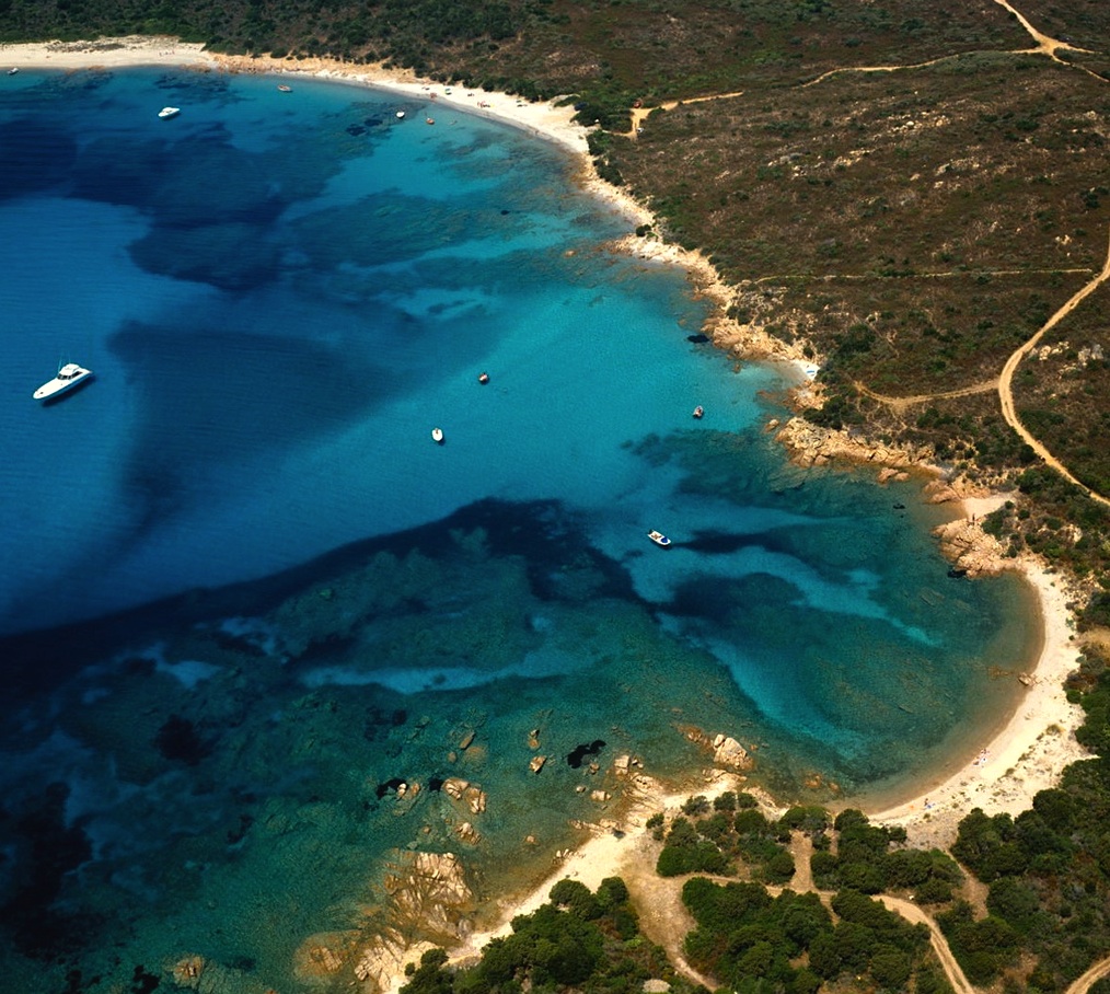
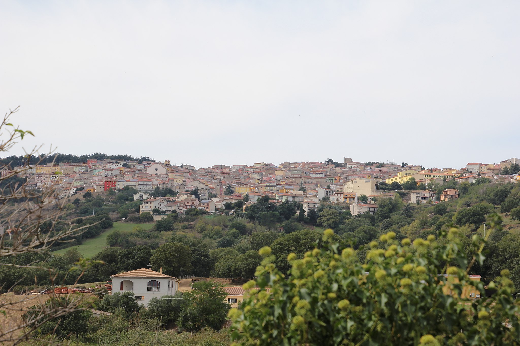
Razza di Giunco
Its name is linked to the giunchi (meaning rushes) that populate the nearby marshy areas and it is no coincidence that unspoilt nature is the recurring theme along this stretch of coast between Portisco and the inlet of Petra Ruja, in the territory of Olbia. In reality, Cala Razza di Giunco has four beaches, including promontories, islets and fjords, creating a spectacular setting, nestled between the pink granite rocks. The beaches alternate white sand and golden sand, sometimes with pebbles, while the crystal clear sea will strike you with its deep blue and emerald green reflections. The shallow waters make it suitable for children, but it is also a destination for snorkelling enthusiasts and it is populated by numerous species of fish near the shore.
The cove is equipped with numerous services: ample parking, rental of sun loungers and beach umbrellas, windsurfing school and equipment rental and a kiosk bar. In addition, the Razza di Giunco coast is dog-friendly: you can relax and have fun in the vegetation, in the sand or in the water with your four-legged friend.
When looking out to sea, you will see the islands of Soffi and Mortorio in the distance. Then, to the east, the outline of the islet of Portisco stands out and, further on, Porto Rotondo and Punta Volpe. To the west, a spectacular promontory embraces the last and smallest of the cove’s four beaches, known as Razza di Juncu.
Further north-west, you can continue your tour of the Costa Smeralda beaches along provincial road SP 94, in the Arzachena area. You will come across Petra Ruja, which stretches in an arch shape and is characterised by its red rocks that give it its name. Then there is Liscia Ruja, the largest and best-equipped beach of the Costa Smeralda, with 500 metres of sandy shore surrounded by rockroses and strawberry trees, with its sand that turns pink as you get closer to the shoreline. Moving on, there is the bay of Cala di Volpe and, one kilometre to the south-west, the seaside village of Capriccioli, with its coastline set between pink granite rocks, surrounded by junipers and wild olive trees and divided into two main coves, with soft, light sand and shallow waters, as well as a sea reflecting captivating shades of colour ranging from turquoise to emerald green.
Lotzorai
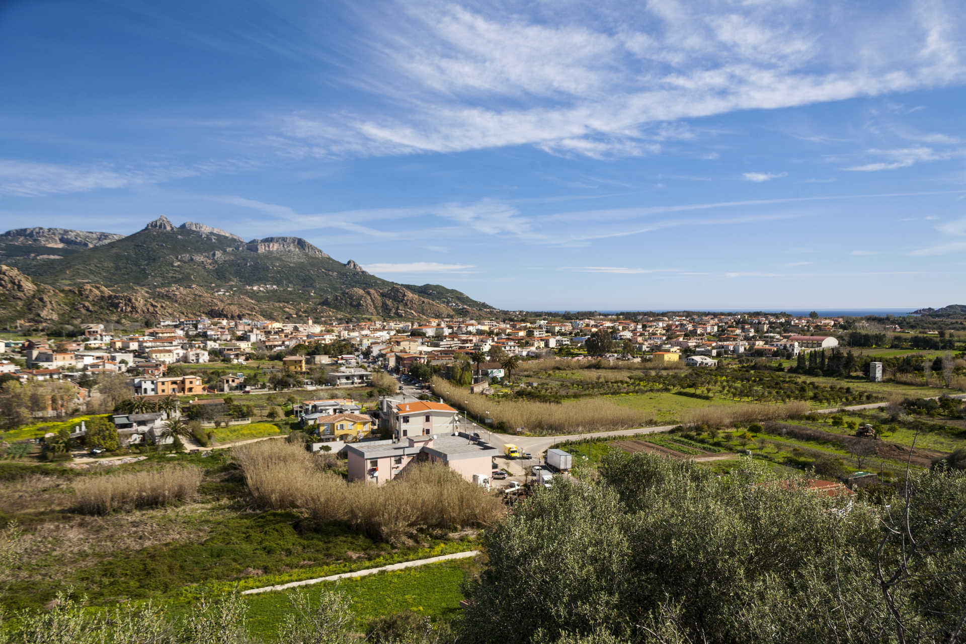
Set between two rivers at the centre of a natural amphitheatre created by Monte Oro, Lotzorai is a farming town-tourist destination in the north-eastern part of Ogliastra and boasts more than 2,000 inhabitants. The town’s layout is typical of rural communities: large houses with spacious courtyards. The narrow streets of the old town centre crisscross over one another and offer some lovely settings. Around town are vegetable patches, olive groves, vineyards and orchards with citrus fruit, while along the seven kilometre long shoreline are hotels and restaurants frequented by sea and nature enthusiasts, by rock climbers, hikers and cyclists. The coastline starts at the little tourist resort of Tancau and leads to the peaches of Pollu, Lido delle Rose, Iscrixedda and Isula Manna.
Facing the town’s beach, about a mile east of the coast, is the little Island of Ogliastra. It is actually a small archipelago of three pink granite and red porphyry islands typical of the seascape here. The largest island is covered in vegetation and the habitat of cormorants, royal and Corsican seagulls. Once a haven for boats in bad weather, it is now a destination for pleasure craft. You can visit it in a canoe or reach it by peddle-boat when the sea is calm, or on boats that sail from Arbatax or Santa Maria Navarrese. At the top, some 50 metres high, stands a statue of the Madonna dell’Ogliastra, a work by sculptor Pinuccio Sciola, a favourite of the many faithful who, at the end of July, celebrate the feast of the Madonna of Peace with a procession of boats. Inland from the coast are marshlands and lagoons: the Pramaera River park, the Pollu and the Paùle di Iscrixedda pond right on the southern border between Lotzorai and Tortolì.
The village’s origins date to the Middle Ages and it belonged to the curatorio of Ogliastra, in the jurisdiction of Càlari. The castello della Medusa dates to that era. It sits on the top of a hill at the entrance to town, perhaps built in the XII century on the remains of a far older Phoenician-Punic construction. The origins of the fortress remain a mystery, but man’s presence in the area dates to prehistoric times, as proven by the necropolis with the about twenty stone domus de Janas di Funde ‘e Monti chambers (2700-1800 BCE) hewn into the rock. The many domus chambers cut into the granite at su Tancau-sa Murta, the pre-nuragic remains found in the su Padentinu woods and, above all, the Orzudeni nuraghe are all fascinating. The town’s most important church is in the old centre, the Parish Church of Sant’Elena, who is celebrated in late August.

Selegas
Selegas is at the heart of the Trexenta subregion, perched between two valleys at the foot of Monte Nuritzi. It is a town with 1,400 inhabitants and an agricultural tradition. The name derives from the abundant cultivations of rye - the ‘black bread’ of the Roman commoners - or from segetes, ‘cereals’, then ‘land of Ceres’, the harvest goddess. Even the urban structure is typically rural, with low-rising houses, their façades embellished with murals that depict the local activities and community and the ‘renaissance subjects’ of painter Liliana Cano. The Sa Domu De Perda event in July is dedicated to these wall paintings. In the ‘heart’ of the town is the parish church of Sant’Anna, in the Gothic-Pisan style of the 12th-13th century, enriched by its marble altar. The bell tower has four bells, the oldest (1608) being engraved with Seligas. The parish museum is connected to the church, which holds statues, liturgical books and sacred furnishings, dated from between the 16th and 19th centuries. The patron saint is celebrated at the end of July with a procession and events that express the deep-rooted customs of the town: an exhibition of garments, traditional music, dances and poetic competitions. Next to the parish is a cave dedicated to Our Lady of Lourdes. At the peak of the village stand the churches of Santa Vitalia, whose patron saint is honoured at the beginning of October, and Sant’Elia, built in 1810 on the ruins of San Pietro, on the possible site of a sacred Nuragic fountain in prehistoric times. Also worth visiting is the 16th-century Oratorio del Rosario and the ruins of Nostra Signora d’Itria, located in the most ‘Romanised’ area, attested by fragments of amphorae, jugs and ceramic crockery along with traces of the Carales-Olbia per Bioram. Another stretch of Roman road emerges in the village of Seuni, two kilometres from the town. An ancient and significant village, it is today populated by 300 inhabitants and preserves the Santuario di Santa Vittoria Martire, dating back to 1581 and rebuilt in the mid-20th century. The saint is celebrated in May, in the same month as the festival of Sant’Isidoro, patron saint of farmers, a much-anticipated event along with the carnival.
The heights of Selegas were inhabited as far back as prehistoric times. In Turriga, a statue of the Mother God in marble limestone was found, being 40 centimetres in height and today exhibited at the National Archaeological Museum of Cagliari. The work is similar to those found in the Aegean. Amongst the Bronze Age ruins stands the Nuraghe Nuritzi complex, of which the fortified tower still stands. The Nuraghe Simieri is connected to the Santu Teru of Senorbì, where a Nuragic masterpiece was found - the bronze of a horned soldier. It arises on the Bruncu Simieri, a clear weathering of ‘Monte dei Sumeri’, where the ziqqurat - temples - where usually erected on the peaks, in contact with the sky. It is not unlikely that in the Eneolithic era, a ziqqurat was knocked down by the Nuragic peoples to extract materials useful for building their settlement. Near the Nuraghe of Bruncu is Olias and Bruncu sa Figu, the remains of a Tomb of Giants and a sacred well emerge.

Ozieri
Its intricate and steep paved roads are arranged in amphitheatre style over a very sloping territory: you will enjoy splendid views of the valley below, which is covered in woods. Ozieri is a little town with over ten thousand inhabitants. It is the most highly-populated in the Logudoro area and is located approximately 50 kilometres from Sassari. It was already the administrative centre of Mount Acuto in the 14th century and in the 18th century it became the second most important town in the northwestern area. Its urban fabric is enriched by pavements that open up into clearings, little terraced squares and gardens and it features roof-terraces and nineteenth century loggias. In the old town centre, one of the most prestigious civil buildings is Palazzo Costi, while among the town's historical locations not to be missed are the Borgia prisons. The main place of worship is the cathedral of the Immacolata, built in the 15th century and transformed in the 19th century.
The town is dotted with churches, starting with that of Santi Cosma e Damiano (16th century) and that of the Rosario (17th century), but the most important ones are outside of Ozieri. The most famous one, which is one of the maximum expressions of Romanesque style in Sardinia, is the majestic basilica of Sant'Antioco di Bisarcio, overlooking the plain of Chilivani. Around it, stands a village, which was once a centre of cultural life and seat of the diocese. The church, which is ten metres high, was built using volcanic rock, in three phases, beginning in the 11th century. Particularly prestigious are the portico with six cross bays and the decoration of the apse. The first mention of the church of San Nicola di Butule dates back to 1135 and it too was built in several construction phases. Also worthy of a visit is the church of San Francesco, to which the Capuchin convent is attached and it is one of the two monasteries in Ozieri. The other is the convent of the Clarisse (Poor Clares), in which the civic archaeological museum is located, containing historical evidence of a territory frequented since prehistoric times. The famous culture of Ozieri that spread throughout the Island during the Late Neolithic period (end of 4th millennium BC) gets its name from the Grotto of San Michele. There are abundant traces of the Nuragic civilization: the Nuraghe of Burghidu and Sa Mandra e Sa Jua, sacred wells and Tombs of Giants. The greatest legacy from the Roman era is the Pont'ezzu, a bridge over the Rio Mannu river. The village went through a happy artistic moment with the works of the painter known as Maestro d'Ozieri. On the subject of art, you should not miss a visit to the Diocesan museum of sacred art .A very unusual exhibition worth discovering is that at the ethnographic museum, La taverna dell'Aquila. Thanks to the Chilivani equestrian centre, Ozieri has always been famous for breeding and training horses, a tradition expressed at the Museum of Horses. As far as food is concerned, the village's most characteristic pastries are the delicious suspiros, which are biscuits, known since 1800, made of almonds, honey and sugar and are glazed.
Nuraghe of Santa Barbara
At kilometre 145 of the State Road 131 (the Macomer-Birori junction in the direction of Sassari), it rises on a basaltic slope on the sides of Monte Manai in a dominant position on the Abbasanta plain. Leaving the main Sardinian thoroughfare, after a short distance travelled along a steep road, the Santa Barbara nuraghe can be admired in all its majesty. It takes its name from the ruins of the rural church dedicated to the saint. It has a complex architectural structure, consisting of a central tower and a quadrilobate bastion almost nine metres in height, which encloses an open-air courtyard. The four towers of the bastion, dated to the 15th century BC, are connected by curtain walls constructed in basalt blocks. Originally, it was defended by a barbican, with an attestation from the 19th century that is barely legible today.
Entry is gained from a quadrangular entrance leading to the courtyard. Here open up the accesses points to the towers. The central one is 15 metres in height and nine metres in diameter. Built with carefully-worked blocks and arranged in regular horizontal rows, the intact areas include a room on the ground floor, with three niches arranged in a cross profile, and a circular chamber on the first floor illuminated by a large window with architraves. The outline of a third room can be seen at the top. The side towers would have once connected to each other through corridors within the outer walls. Towers B and C are well preserved. The first, reachable via a short passageway, has a circular layout of over three metres in diameter. A trapezoidal entrance opens in a wall and leads to a small level with three large niches-embrasures. Tower C, also circular yet larger (at four metres in diameter and five in height), is accessible directly from the courtyard via an architraved entrance, and shows two niches-embrasures and three cabinets. Towers D and E are almost totally destroyed. Around the Nuraghe structures are the remains of a large settlement, which lasted for a long period from the middle of the 2nd millennium BC until the Roman era, and then the early Middle Ages.
In addition to that of Santa Barbara, other buildings from the Bronze Age dot the Macomer territory. Worthy of seeing are the burial complex of Perdas de Tamuli and the Ruju Nuraghe structure, mono-towers with a 13-meter diameter. Alongside stands a monument from the beginning of the 2nd millennium BC - the four Domus de Janas of the Filigosa necropolis. The earliest traces of humankind are in the Grotta Marras, with the discovery of a statue of the Mother Goddess (‘Venere di Macomer’) that dates back to the Upper Palaeolithic period. In the Punic era, Macomer was perhaps Macopsissa, a city cited by the geographer Ptolemy (II AD). In Roman times the centre was a strategic place of passage, as is evidenced by the remains of streets and six milestones, two preserved in the G.A. Sanna museum in Sassari.
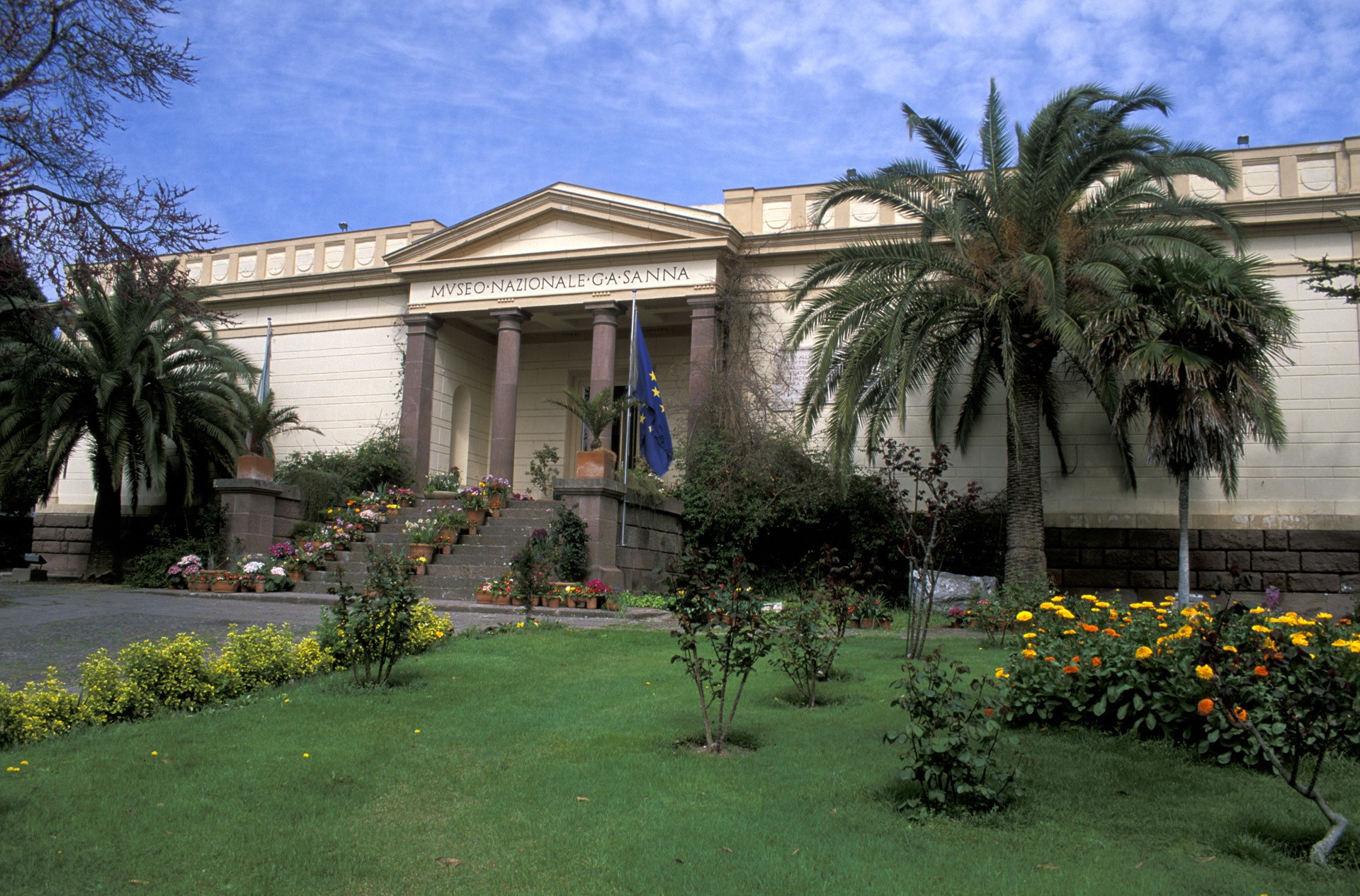
G. A. Sanna National Museum
Giovanni Antonio Sanna was a politician in the kingdom of Sardinia and an important entrepreneur, as well as concessionaire of the mines of Montevecchio. In his will, he left his precious, rich archaeological and artistic collection (250 paintings from the 15th to the 19th century) to Sassari, the city in which he was born. This donation, made in 1878, was the first nucleus of what was to become the future museum, later implemented by artefacts from research and excavations by the Superintendence for Archaeological Heritage and from private collections. Today, the museum is located in a building in Via Roma, donated by his daughter, Zely Castoldi. Created between 1926 and 1932, its elegance resembles that of a classical temple: the flight of steps at the entrance is made of red vulcanite and it is set back from the road. In the centre, there is a protruding body with Doric columns and a tympanum, while in the lateral wings, which are finished with plaster made to look like smooth stone, there is a cornice supporting a parapet with coffered designs containing round reliefs. Between 1966 and 1973, other areas were added to the symmetrical internal rooms, from existing and new constructions, with a more articulate and modern tendency.
The original division into three sections - archaeological, ethnographic and pictorial - was renewed based on a chronological and topographic order suited to a wider audience. A pavilion for temporary exhibitions was created and the 'Monte d'Accoddi' and 'Romana' rooms were reorganized. Other more recent works have been carried out on the medieval section and the transfer of the collection of paintings to the Mus'A picture gallery. Today, the archaeological part consists of seven rooms: prehistory, pre-Nuragic temple of Monte d'Accodi, domus de Janas, Nuragic civilization, a Phoenician-Punic room (with Etruscan and Greeks artefacts found in the sites), a Roman room dedicated particularly to Turris Lybissonis (the present-day Porto Torres) and lastly a medieval room. The clarity of the exhibition will allow you to acquire immediate knowledge of the archaeological and artistic affairs and the traditions of central-northern Sardinia.
To complete our cultural tour of Sassari, a few hundred metres away, you will find religious monuments, including the cathedral of San Nicola di Bari and the churches of Santa Maria di Betlem and Sant’Apollinare, la most ancient in the city, while of the civil monuments, there is the picturesque Piazza d’Italia. Further away from the centre, there are other symbols of Sassari, including the Fontana di Rosello fountain and the Park of Monserrato, a green oasis in the outskirts.

Vallermosa
The name of Vallermosa derives from the Spanish hermosa, meaning ‘beautiful and fertile valley’, in a word ‘ridente’ (Italian for ‘delightful’). Vallermosa, a village of the Iglesiente subdivision with around 2,000 inhabitants, lies in a valley bordered by two streams at the foot of Monte Cuccurdoni Mannu, on the eastern borders of the Monte Linas massif. It is 15 kilometres from Villacidro, thirty from Iglesias and 45 from Cagliari. The Campidanese houses in clay brick with artistic gates embellish the historic districts of Prazz'e Cresia, Cruxi Santa, Cabina e s'Ecca Manna. In the centre stands the parish church of San Lucifero, dating back to the 17th-18th century. In the countryside, the Santuario di Santa Maria can be admired, near which stand the Roman baths (3rd-4th century A.D.). The local festivals feature a jubilation of colours and sounds of traditional garments and musical rhythms. The patron saint is celebrated on 20th May, Santa Maria between 7th and 9th September with a procession from the parish to the country church and a spectacular torchlight procession on its return.
The great naturalistic attraction is the Linas. Covered by dense forests interlaced with streams and waterfalls, it has an alpine landscape with wild peaks, deep gorges and steep rock faces dating back some 300 million years. Amongst the pink and grey granite peaks are almost 8,000 hectares of holm oaks and various Mediterranean tree species, such as strawberry trees, lentisk trees and European olive trees. The lush vegetation is home to, amongst others, the Corsican red deer with the golden eagle flying overhead. A number of paths lead through the woods, to be traversed on foot, by bike or on horseback. In the territory around Vallermosa are lush hills, including one on which stands the park of Gutturu Mannu (‘Great Gorge’), five kilometres from the town, an enormous canyon zigzagged by a stream and covered by 35,000 hectares of forest, one of the largest green areas in Italy. It is a popular destination for trekking enthusiasts, with areas for resting and picnicking. The park is wildlife oasis, with fallow deer and mouflons wandering freely. Also to be discovered is the life of the civilizations of yesteryear in a stretch of land uniting history and nature. Four kilometres from the forest is the archaeological area of Matzanni, which houses a wall structure, three temples with a Nuragic well, surrounded by a village of 13 huts and the ruins of a Punic temple. The most precious artefact found is the small bronze ‘Barbetta’ statue, exhibited in the National Archaeological Museum of Cagliari. On a hill near the village stands the Nuraghe su Casteddu de Fanaris, from which picturesque scenery can be admired. The territory has been inhabited since the Nuragic period and again in the Punic-Roman period, but the origins of the town date back to the mid-17th century, in the context of the events of the Spanish feudal Sardinia: Blasco de Alagòn, the Marquis of Villasor, organised a massive migration of families to the depopulated villages of Pau Josso and Pau de Vignas. From here, the urban development began.

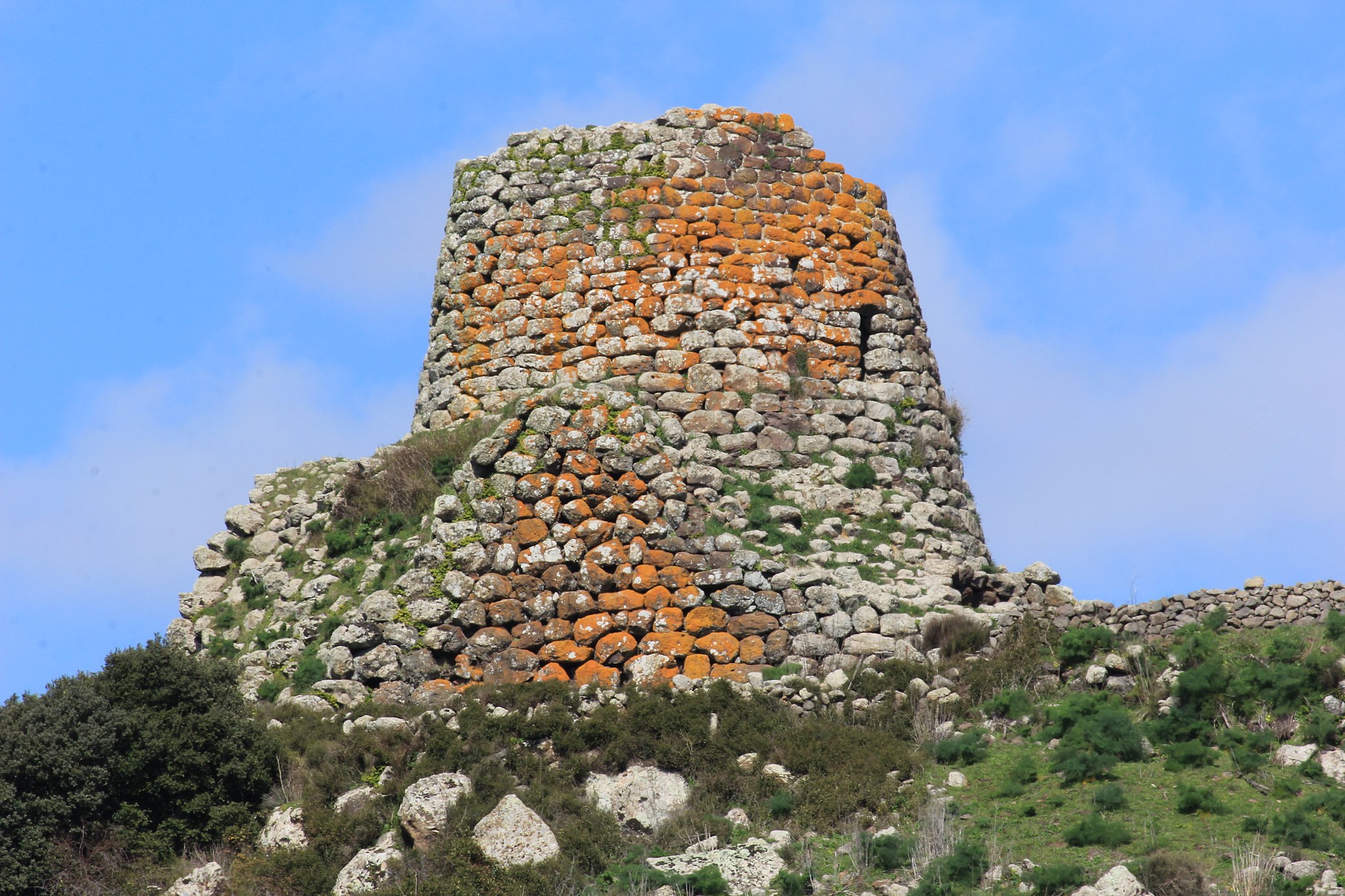
Castello di Medusa
Distant and almost inaccessible, the castle of Medusa has left few traces in history, almost as if it never existed. In contrast, it is the subject of infinite imaginative legends. This mysterious rock, surrounded by solitary hills, ravines and crevasses is set in an impervious landscape where falcons nest, riven by mountain torrents and ancient woodland, domus de Janas and nuraghes. It clings to the hillside of sa Conca 'e su Casteddu, on the edge of the rocky ravine formed by the riu Araxisi river with its limestone cliffs covered in greenery and ridden with caves. The location falls under the territory of Samugheo, an equal distance from the "carpet town" and Asuni, in the heart of Mandrolisai. It is an "anomalous" castle, built at the bottom of the valley, almost hidden, placed to control the traffic from the "Romanised" plains near Forum Traiani to the hills of Barbaria, inhabited by rebel populations.
Once the only road to the Barbagia region passed beneath the fortress, which can now be accessed by a narrow, asphalt road that brings you within 500 metres. From there, continue on foot (or in a jeep) along paths through the woodland that run right up to the castle, It was built during the "Lower Empire" (4th-5th century AD) as a Byzantine castrum, and was later modified twice, in the 6th and the 7th-8th century. The rectangular layout, western battlements and two towers, one with a cistern, date back to the first construction phase. The eastern battlements were built between the 10th and 11th century, when it became a frontier castle between two jurisdictions. The walls, which are now overgrown ruins, originally enclosed an area of around 540 square metres. The castle is first mentioned in a document from 1189, which talks of a castrum Asonis transferred to Genoa by the Judge of Arborea; in 1389, it was restored by Judge Eleonora. The name "Medusa" arrived only after 1480, and it was also known as "di Giorgia". Medusa was an ancient Sardinian pagan goddess. Spano talks about her "home" in the archaeological Bullettino (1860), describing it as home to ghosts and demons, with walls two metres thick, a tower saved from treasure hunters, and caves and rooms dug out of the rock. In legend, it is an enchanted place full of treasure, built by Phorco, who came from Africa to proclaim himself King of Sardinia. When he died (253 AD), his daughter, Princess Medusa, reigned for 28 years: she was an intelligent, warrior-like woman who was the most beautiful on the island, as well as being a jana who could work magic. She died in battle, killed by Perseus, and left the castle and its treasure to the devil, protected by the souls of those who had guarded it, who would transform anyone arriving into blocks of stone. The castle's treasure frequently features in the stories about it, such as an episode that is midway between history and fantasy form the mid-19th century: an Asuni bandit named Perseu (coincidence!), sentenced to seven years in prison in Genoa, told that when evading capture he had hidden in the castle, and found himself in an amazing room full of jewellery, weapons and valuables. He was granted permission to return and find the treasure in exchange for a pardon. Once in Sardinia, no room or treasure was found; nonetheless, locals continue to believe it exists, closed in chests and protected by lethal magheddas flies. In other late-Medieval "chronicles", Medusa is confused with other popular figures such as Maria Cantada and Luxia Arrabiosa.
Pattada
Perched at an elevation of 900 metres, it conforms to the south slope of the Limbara, a massif dominating the panorama of Monteacuto in eastern Logudoro. Pattada is the “highest” inhabited centre in northern Sardinia. A town of 3500 inhabitants famous for its handmade switchblades with a steel blade and mouflon horn handle. The “resolza of Pattada” is a work of art, a cult object prized by collectors all over the world thanks to its shape, durability, finish and inlays of precious stones and metals. Every two years, in August, the Knife Museum hosts the “Biennale del coltello di Pattada” (Pattadese Knife Biennial Exhibition), a display of knife collections of local as well as international collectors. The workshops of knife-makers along the streets can also be visited. Wooden items are also of excellent quality here, especially the bowed string instruments; as are the cheeses: tasty perette, ricotta and Pecorino cheese varieties made here are exported worldwide. Sweets include the delicious honey origliettas. Bread and pasta are also a must-try: su misturu and sas pellizzas.
In April, you can learn about the culture, food and wine during the Abbuconizos e Binu Festival held in a historical centre with picturesque views. Paved streets are lined with stone houses with wooden decorations and shutters and Neo-classical mansions, such as Su palattu ‘e Manuelle (now the town hall). At the beginning of the 20th century, the town was embellished with fountains and with the Square of Sardinia’s Poets, decorated with a sculpture of Pinuccio Sciola. Local writers have named Pattada Lugodoro’s “cradle of poetry”. The town is also known for its able riders, who perform in wild races and acrobatic exhibitions during the island’s festivals and palio. This end of August competition between the town’s ten main districts takes place during the patron saint’s Feast Day, which is also marked by a parade of horsemen, period dress and canto a tenore singers that sets off from the 16th century Parish of Santa Sabina. The church, built in the Catalan Gothic style and restored several times, is full of architectural and decorative detail. The Catalan International Gothic Church of Rosario (16th century), the Church of San Gavino, at the town’s highest point, and the 14th century nave of San Giovanni are also a must see. San Giacomo and San Pietro are the churches in Bantine, where three kilometres of well-preserved Roman road can be seen. San Nicola and San Michele are those of Biduvè, a Medieval village now gone. In June, the Feast of Madonna del Carmelo is celebrated.
The territory’s main peak is Monte Lerno, covered by woods and dotted with springs. Placid lakes adorn woods of the same name populated by donkeys, horses, eagles and falcons, as well as reintroduced red deer, fallow deer and mouflon. Since 2004 the mountain also hosts a stage of Rally Italia Sardegna, a WRC event, on one of the championship' most exciting routes. A lake, around which excursions on foot and horseback are possible, also takes its name from the mountain. Its surface, under which a pre-nuragic village was found, reflects the stones of Nuraghe Lerno, the most famous of 40 found here. Others include Sas Domos de Sa Terra, Sa Niera, linked to a sacred spring, Ottinera and Sant’Elia, associated with Giant’s Tombs. Norchetta’s allée couverte and the walls of Lamparigos and Sa Chidade are even older. On the northern slopes, the ruins of the Castle of Olomene from the Giudicati era can also be seen.
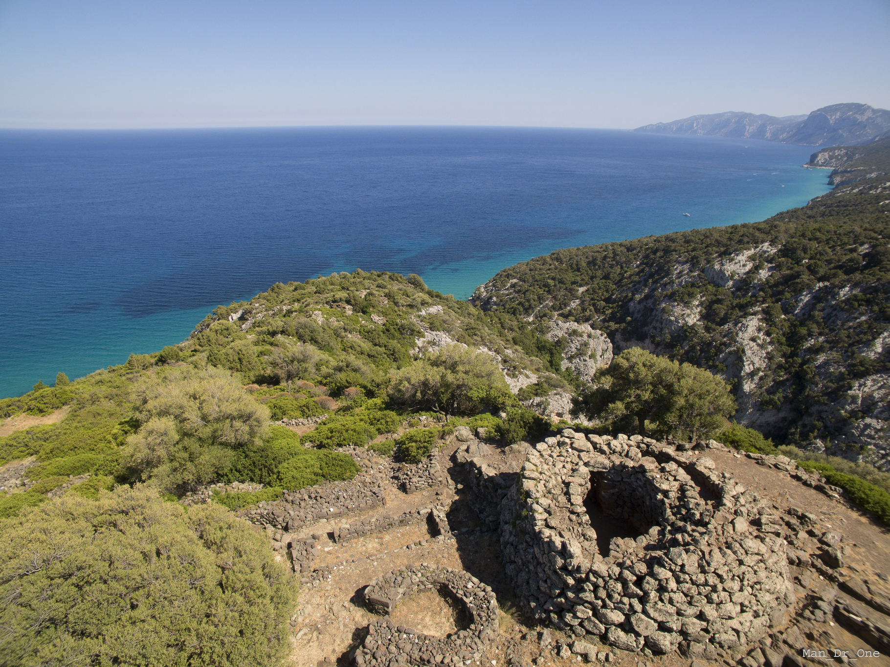
Nuraghe Mannu - Dorgali
The Nuragic civilization developed both inland and on the coast. The archaeological legacies of Dorgali bear witness to how considerably frequented and culturally lively the Sardinian coasts were during the Protohistoric period. The symbol is the complex of the nuraghe Mannu, perched on the top of a promontory, 200 metres above the sea, with its dizzying basalt rock face that descends to the codula of Fuili, a short distance from the Grotte del Bue Marino (Sea Oxen Grottoes) and Cala Luna. The dominant and scenic location was strategic and the view extends across the entire Gulf of Orosei. A path leads up from Cala Fuili close to the archaeological area. It may have been plotted by the Nuragic people in order to reach a nearby landing place. Arriving by car, the diversion leading to the Mannu is at the fourth kilometre along the road that leads to the village of Cala Gonone. From the junction, the nuraghe is two kilometres away and the last 800 metres need to be covered on foot.
The area of the Mannu is made up of a single-tower nuraghe in the centre of a settlement that was first Nuragic and then Roman, stretching for more than two hectares. The tholos tower (false dome) is built with irregular rows of large vulcanite boulders and basalt. It is currently almost five metres high, with a thirteen-metre diameter at the base. The architraved entrance leads into a covered flat arch corridor, which leads first to a stairwell - of which twelve steps remain - and then to a room almost entirely obstructed by a collapse. In the external walls you will notice four niches, probably guard posts, which functioned for sightings and defence of the dozens of huts around the nuraghe. The name Mannu (large) can be attributed to the extensive settlement more than to the monument. The huts near the tower are round and were built with unpolished stones; as you move away, they become rectangular. On the edge of the ravine, the village is protected by a wall that is integrated into the rock. About a hundred metres from the complex lies another settlement, one of the largest of Nuragic Sardinia, su Nuragheddu, with more than 200 huts of various shapes and sizes, not yet excavated.
In the end stages of the Nuragic age, the area was frequented by Phoenicians, Punic people and then by cives of ancient Rome during the Republican and Imperial age. The coexistence of different cultures is evident: the Mannu is the ideal context for studying the final evolution of the Nuragic civilisation and the Romanisation of Barbagia. Roman buildings were constructed over the Nuragic huts, both those for civil use and also warehouses with silos, millstones and storage jars. Each building is made up of two communicating rooms. The walls were built from reused or semi-finished ashlars and the roofs were made of roof tiles and curved tiles supported by a wooden truss.
Antonio Taramelli (1927) was the first person to explore the area. From 1994 to date, a remarkable quantity of ceramic and stone fragments for everyday use have emerged from a long series of excavations - pots, pans, cups, whorls, loom weights, pestles and millstones -, ranging from the Middle Bronze Age to the Iron Age (16th-9th century BC). A stele was also found, implying that there was a Tomb of Giants nearby. Fragments of bricks and ceramics provide proof of the Roman era, while urns from the Late Roman Empire, African terra sigillata with Christian symbols and 4th-6th-century roof tiles are evidence of the site’s Late Antiquity and Byzantine phase: continuity that confirms its strategic placement along the coastal trade routes. A selection of artefacts, from the Protohistoric period to the Early Middle Ages, is on display at the Archaeological Museum of Dorgali.
Mannu and Nuragheddu are two of the countless prehistoric sites in the Dorgali territory. La necropolis of Conca ‘e Janas is one of the most ancient legacies, while other domus de Janas are Pirischè and Isportana. Slightly more recent is the dolmen of Motorra, one of the best-known on the Island. The complex nuraghi that stand out are Purgatoriu and Oveni, located 500 metres from the sanctuary-village, and Serra Orrios, which has one hundred huts, a meeting room, and two megaron temples, making it one of the main Nuragic settlements. The single tower of Gulunie also functioned as a lookout post, close to Cala Osalla. Other Nuragic villages are the 130 huts of the nuraghe Arvu and the most famous of all, that of mount Tiscali. The ultimate Tomb of Giants is s’Ena ‘e Thomes and dates back to the Early Bronze Age.