
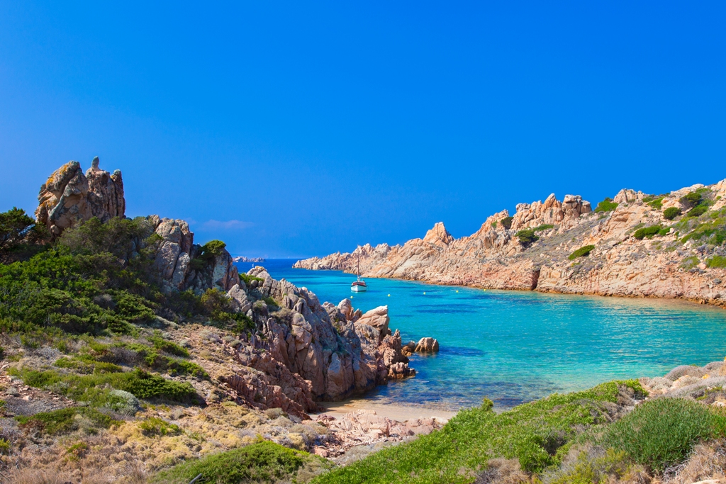
Razzoli - La Maddalena
This is the penultimate bulwark of Sardinia on the border with Corsica - further north is only the "twin" island of Santa Maria. The high cliffs of Razzoli dominate from the north the park of the Maddalena archipelago, of which it is the fifth largest island with an area of one and a half square kilometres and a coastline of over twelve kilometres. The larger islands are La Maddalena, from which you will leave to go to Razzoli and the other islands, Caprera, Garibaldi’s "garden", connected to its "older sister" by the Moneta Pass, Spargi and Santo Stefano. Razzoli is the largest of the northern "trio", also composed of Budelli - with its legendary pink beach (Spiaggia Rosa) - and Santa Maria, a few meters away and connected by the Asinelli Pass.
The unmistakable characteristics of Razzoli are the jagged coastline and a mountainous conformation; the highest peak is Monte Cappello, 65 meters high, while what is most fascinating is its history that preserves mysteries that have become increasingly intriguing and evocative over the centuries. The pristine vegetation and marine fauna are the main attraction - not surprisingly, among the 60 islands and islets of the archipelago, it is the one with the wildest appearance. It forms a natural embankment with its high granite cliffs, clashing against the elements of an often rough sea at the northern end of Sardinia. The rocks shaped by sea and wind are authentic natural sculptures. Some sheltered coves are real 'gems': Cala Cappello, Cala Noce, and Cala Lunga, accessible only by sea and composed of pebbles and fine sand, and other small sandy coves like Cala Bove Marino: here in the past, not far from the shoreline, you could see the 'shy' monk seal, last sighted off the cove in 1997. The shades of the sea vary between blue and deep blue, with a seabed rich in marine fauna and flora, perfect for snorkelers.
Inland, among granite rocks and Mediterranean scrub, especially helichrysum and junipers, ancient mule tracks allow you to enter the heart of the island, inhabited mainly by sea birds, until you reach the lighthouse, built in 1974 next to the previous building dating back to 1843. You can visit the imposing structure that rises above the sea and whose great light reaches up to 13 miles from the coast. The building is connected to the beach of Cala Lunga by a mule track characterized by a rail track used by the families who inhabited the island to transport fuel and food supplies. Just before the lighthouse, guarding the tormented Bocche di Bonifacio, you will see a tomb with ancient legends. The story has it that a young woman, the daughter of a lighthouse keeper, was buried here after dying in childbirth, and that on some nights her harrowing lamentations can still be heard. According to others, the tomb preserves the bodies of two French sailors who were shipwrecked in 1855.
Serramanna
Serramanna lies in the central-western part of the Campidano plain, one of the most fertile areas of the island, where the Leni torrent intersects with the Flumini Mannu. Serramanna is a city of just under 10,000 inhabitants, which has always been based on agricultural production, especially wheat and vegetables. Today, it is one of the largest fruit and vegetable producers in Sardinia. The communal winery producing excellent wines and the still-active canning industry have enjoyed great renown. The historic centre is comprised of typical Campidanese houses, with entrance portal, courtyards, sas lollas and various environments for working and lodging, with highlights including the Casa Cadoni-Arcais and Casa Abis, with a long portico with pointed arches. Amongst the historic buildings to be admired is the Monte Granatico and the headquarters of the Società Operaia (operatic association).
The houses in the town are arranged around the San Leonardo parish church, built over in a number of differing periods, hence the Gothic-Catalan, Aragonese and late-Baroque fusion. It is characterised by a Latin cross layout and a tall octagonal bell tower, designed by the architect Antonio Calabrès. Also worth visiting are the churches of Sant’Ignazio da Laconi, and San Sebastiano, which housed the Dominicans between 1631 and 1854, and that of Sant’Angelo (16th century), which contains the Museo delle Memorie e delle Tradizioni Religiose with various thematic areas: precious and sacred furnishings with liturgical functions, sculptures, statues, silverware of sacred art and ex voto. In the countryside is the church of Santa Maria di Monserrat, dating back to the year 1000, cited in 1089 as part of a donation made by the Giudicato of Cagliari to the Benedictine monks. Serramanna was also a pilgrimage destination for the 2000 Jubilee. During the excavations carried out in the sacristy of the rural church, the most significant finding from the Nuragic age reappeared. Other Nuragic structures have been identified in Santa Luxeria. The first settlements within the Serramanna territory date back to the Neolithic village of Cuccuru Ambudu and the menhir Perda Fitta, a granite boulder representing the Mother Goddess. There were numerous rural villages during the Roman domination, with the remains from this time kept in the National Archaeological Museum of Cagliari. In the Middle Ages, Serramanna was divided into numerous Villas, including five main ones, whilst with the advent of feudalism, it passed through various noble families. In 1617, Antonio Brondo y de Ruecas was named the first count of Serramanna by King Philip III of Spain, an appointment that continues to this day.

Sanctuary of Sant'Anastasia
It stands in the upper part of Sardara, a village in the Medio Campidano area, and it gets its name from the little church nearby. The Nuragic sanctuary of Sant'Anastasia is characterized by a sacred well, known as funtana de is dolus (well of the pains), from which the spring emanates and is fed by groundwater aquifers. Thanks to a draining mechanism, you can enter it and admire its solid architecture, going right down to the bottom. Created with basalt and limestone blocks, perhaps in the Late Bronze Age, it has a circular room with a false dome roof, which you can get to via a flight of steps protected by a corridor covered with slabs in a jack arch arrangement. In the temple, of which only the well still remains, the water deities were worshipped, like in the Sanctuary of Santa Cristina (in Paulilatino), that has a similar structure but is perhaps from a later period.
The use of the area for religious purposes continued on after the Nuragic era, as is confirmed by Punic pottery and the remains of a Byzantine building beneath the church of Sant'Anastasia (rebuilt in the 15th century), in which there are two naves separated by pointed arches resting on pillars. Inside the church, there is another Nuragic well, of which several ashlars decorated with engraved patterns - one shaped like a taurine protome - are walled into its façade. In the well, which is smaller than sa funtana de is dolus, numerous pots from the Iron Age (8th century BC) were found. The excavations in the surrounding area have unearthed a large curvilinear enclosure alongside which there is a path of stone slabs. Inside it are the huts of a village that extends mostly beneath the current houses in Sardara. They are the remains of a vast Nuragic settlement, not just religious but also civilian, that continued on from the Recent Bronze Age to the Early Iron Age, and was also frequented in later periods. The enclosure incorporates a large circular hut, maybe a Council room, with a seat that runs along the perimeter wall. Here, as well as furnishing elements, among which a stone alter shaped like a Nuragic tower stands out, there are numerous artefacts unique in the Nuragic context: terracotta melting moulds, lead ingots and a pot containing precious bronze relics. You can admire them in the Abbas Villa city archaeological museum. Not far from the excavations, you can also visit Casa Pilloni, a dwelling that dates back to earlier than the 17th century and is currently a centre of services for the enhancement of the archaeological site.

Villa San Pietro
It stretches along the foot of Mount Punta Sa Cresia, half an hour from Cagliari. Villa San Pietro is a village with an agricultural and pastoral vocation and two thousand inhabitants, in constant growth since the end of the nineteen sixties, making it unique among the island's Municipalities. Its territory does not have an outlet to the sea, but it extends as far as the beach of large-grained sand and pebbles of Porto Colombu, near the tourist port of Perd'e Sali, not far from Pula and from its marvellous shoreline. In the hinterland, there is the lush forest of Monte Nieddu, which extends over granite massifs, and the green expanse of Is Cannoneris, a wildlife oasis repopulated with Sardinian deer and fallow deer and moistened by various watercourses. Forests of holm oaks, Mediterranean scrub and conifers disappear on the horizon: you can travel through them along well-marked trekking trails. From the summit of the territory, Punta Sebera, you can admire part of the Gulf of Cagliari and the southwestern coast.
The village, which emerged around the year one thousand, gets its name from the pretty Romanesque church of San Pietro. Built around the end of the 13th century, it has a single nave and a wooden roof. The façade is adorned with a belfry and an oculus. The interior was originally built with terracotta and granite slabs and the floor was entirely paved in stone. The celebrations in honour of the patron saint take place at the end of June. The evocative Festa di Sant'Efisio celebration takes place in stages: the saint's carriage passes through Villa San Pietro on 2 May and continues on through Nora; on 4 May, on its way back, it stops at Villa Atzori.
The first nucleus of the village was Roman, while the territory has been inhabited since the Nuragic age: there are three Tombs of Giants, Su Cuccumeu, Perda e’ Accuzzai and Su Lilloni, and the Mereu Nuraghe, which is still partially buried on top of a hill on the border of Sarroch, around which there may have been a village. The megalithic tomb was connected to the settlement, a few tens of metres away. The remains of other villages are in Porcili Mannu and Sa Sucraxia, located inside the forest. The most likely hypothesis is that they are the dwellings of families of Moors, enslaved by the Romans and forced to work in the mines of the Sulcis area. There is a necropolis near the ruins of the dwellings.
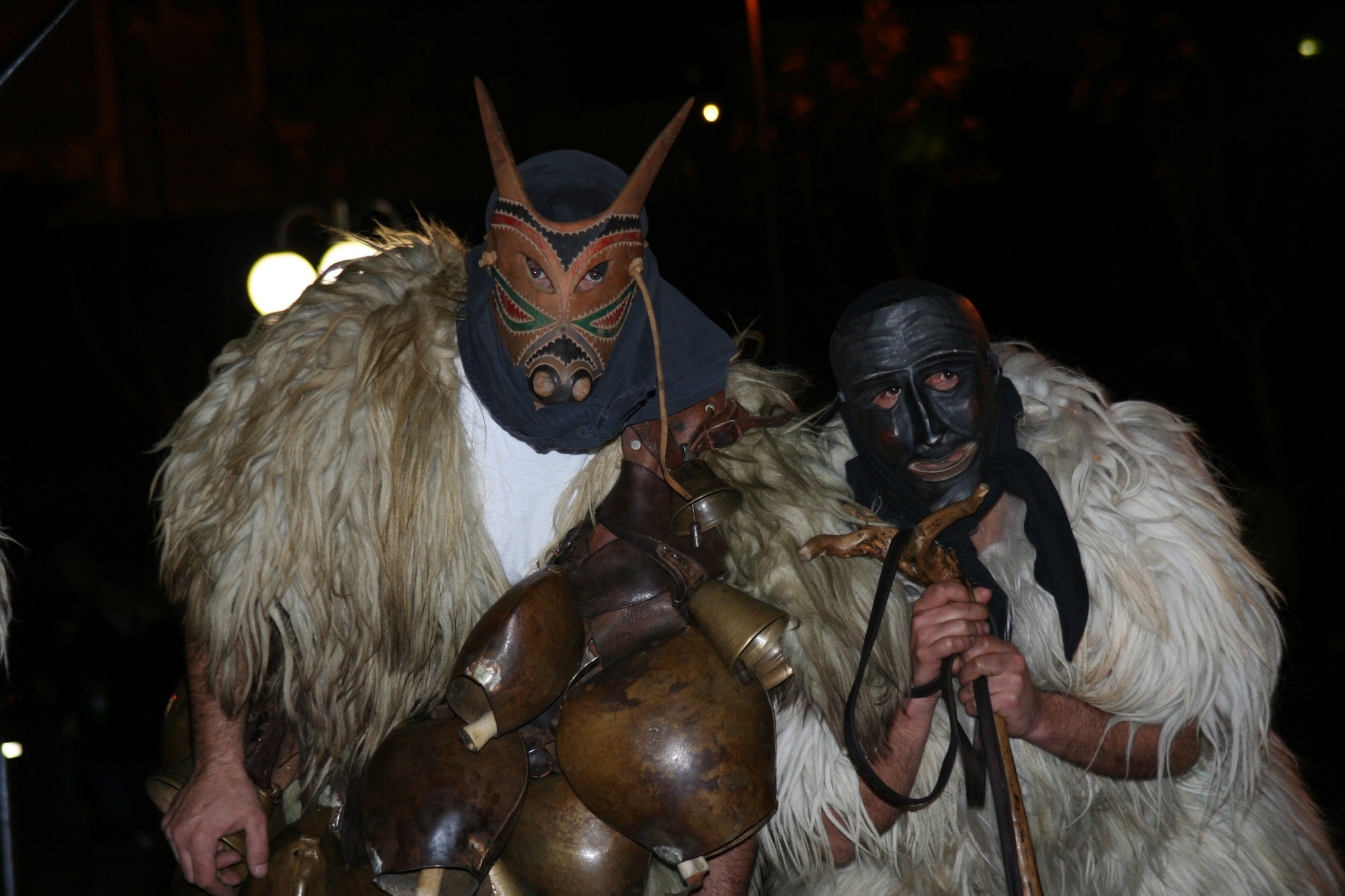
Ottana
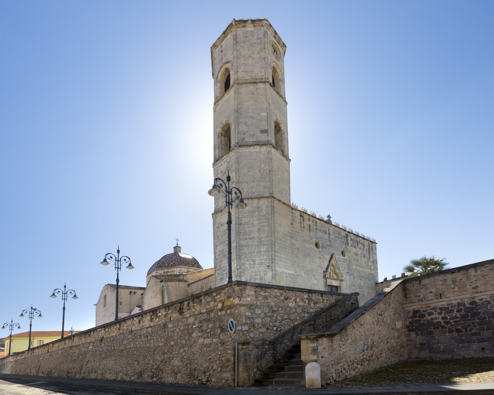
It was once an episcopal see, symbolized by the former cathedral, and today it is the village of Boes and Merdules, wooden monstrous-looking masks, protagonists of one of the Island's most famous carnivals. The village of Ottana was originally pastoral and, at the end of the 20th century, it became a site for the petrochemical and textile industries. Today, it is mainly dedicated to agricultural activities, artisan agri-foods and wood. It has two thousand 300 inhabitants and stands near the hills of Barbagia di Ollolai, on a large plain in the valley of the Tirso river, that forms lake Omodeo a little further south. Ottana has deeply-rooted traditions that have resisted over time, among which Su Carrasegare. The masks of Ottana retrace the archaic agricultural and pastoral rituals.
It is during the Fuochi di Sant'Antonio Abate (Fires of St Anthony) that the Merdules (hunters) and Boes (animals to capture) come out for the first time, in mid-January. The Holy Week rituals are deeply heartfelt and culminate with S'Iscravamentu, an engaging ceremony accompanied by the choir of sos tenores. The Assumption of Mary into heaven is celebrated on the 15 August Ferragosto holiday. Flavours are also linked to its origins. Among the breads, pane fresa stands out, while among the specialties, there are the sos cogones, filled turnovers cooked in the oven, and among the pastries, there is s'angule, a symbol of Ottana and originally made as an ex voto offering. You can taste it during Autumn in Barbagia and, at the end of May, during the celebrations in honour of Santu Nigola. One of the main religious monuments in Barbagia, the church of San Nicola is dedicated to the patron saint. The austere and charming Romanesque architecture, a cathedral from 1112 to 1503, dominates the historical centre with grandeur and alternates the two colours of the black-violet basalt and pink trachyte. Inside the high and 'austere' interior, there is the Pala di Ottana, a fourteenth-century polyptych by the Master of Franciscan tempera painting. Next to it, there is the fifteenth-century church of Santa Maria.
The village has very ancient roots, dating back to the Recent Neolithic period, which is demonstrated by the Domus de Janas necropolises of Sas Concas and Sorgosío, walls and megalithic structures, and to the Metal Age: there are about ten corridor nuraghi, some with tholos, approximately 15 single-tower and few complex ones, various villages of huts, dozens of tombs of Giants and the sacred well of Zuncos. The archaeological area of Bidinnannari is the main site, made up of 'mixed' nuraghe - two towers have been added to one corridor nuraghe - an inhabited settlement extending for 400 square metres and funerary buildings: a small dolmen, four tombs of Giants (one of which is well-preserved) and one allée couverte tomb. The complex of Talinos is also interesting, with single-tower tholos nuraghe and circular huts. The ruins of the thermal structures of Banzos also remain, dating back to the Roman age, when Ottana was a highly populated centre and one of strategic-military control for fighting the barbarians.

Villasalto
Nestled 500 metres high on a plateau that alternates sinuous forms with steep slopes and deep crags, the Gerrei town of Villasalto includes 1,000 inhabitants, having experienced a mining epoch thanks to the Su Suergiu mine, the foundry of which produced 90 percent of the antimony of all Italy, used for war purposes. Extraction and processing activities lasted a century (1880-1987) - also in the minor mines of Sa Lilla and Parredis - which took a downturn in the post-war period. Today, 19th-century buildings, a mining village and a building dating back to the beginning of the 20th century that houses an archaeological-mining museum, are precious ‘pieces’ of the Parco Geominerario Storico e Ambientale della Sardegna. The historic part of the town, whose name derives from saltus (countryside), arose around the 17th-century parish church of San Michele Arcangelo (the parish saint being celebrated at the end of September), which safeguards paintings and 17th-century wooden statues plus an organ from the 18th century. The most recent part was built around the Sanctuary of Santa Barbara, founded by Byzantine monks and rebuilt in the mid-19th century. For the patron saint of miners, the most adored festival takes place at the beginning of June. It is repeated on 10th July together with the Sagra della Capra (food fair dedicated to the goat). Tastings of meats and cheeses can also be enjoyed in spring with the su Sinnadroxiu. In mid-January, bonfires are lit for celebrations dedicated to Sant’Antonio and San Sebastiano. A much-anticipated event is the is Animeddas, the Sardinian version of Halloween.
The territory of Villasalto is one of the wildest and most evocative in the south-east, rich in springs and covered with holm oaks and oaks. To the east, it overlooks the valley of the Flumendosa, from where one can spy a succession of imposing ramparts that fall on the riverbed and frame the woods. Granitic slopes and spiers of Mount Genis, an elevation that separates the Villasalto plateau from the Sarrabus and a fauna oasis inhabited by mouflons, are covered by a centuries-old holm oak wood. From the summit, the panorama embraces the northern Tacchi d’Ogliastra and Gennargentu, to the south the Sette Fratelli park. Amidst the Mediterranean scrub, there are bizarre rocks carved by time, as if an eagle were perched on top. To the west, the plateau is bordered by Mount Arrubiu and its forest, populated by a colony of deer. Here, the remains of a village and the Roman necropolis of Cea have emerged, a mysterious settlement perhaps linked to the argentiferous veins in the area. Other itineraries to be explored include those of the valleys of the Rio s’Acqua Callenti and on the promontories of Monte Lora. Nearby, sa Grutta ‘e Scusi open up, a hollow that is famous for cave formations and the presence of ‘geotritone’ (cave salamander), a Sardinian endemic reptile. On the Genis, at 700 metres above sea level, there is a large Nuragic complex, sa Dom’e sa nì (‘house in the snow’), consisting of tower, walls and circles (huts or places of worship), used in modern times to preserve ice. From below the eastern ridge of the mountain, the Nuragic village Arcu ‘e sa Tuppa arises. There are other Nuragic structures, the Pala Perdixi complex and the Tomb of Giants of Aligamu.
Capoterra
Capoterra stretches along the foot of Mount Arcosu and it is washed by the Stagno di Cagliari lagoon – known as Santa Gilla. Capoterra is a town with approximately 23 thousand inhabitants at the southwestern gates of Sardinia's capital city. In its immense territory, which has been inhabited since the Pre-Nuragic period, nature and history are intertwined. You will find enchanting and remarkably interesting landscapes on Monte Arcosu, consisting of almost four thousand hectares of forest, with a 'heart' of holm oaks and cork oaks, surrounded by Mediterranean scrub, where the Sardinian deer and the fallow deer wander undisturbed. The park is kept moist by watercourse and waterfalls. Located within the 1300 hectares of the Cagliari lagoon, one of the most important birdlife oases in Europe, there is the pond of Capoterra, where you can take a comfortable position and observe flamingos and black-winged stilts. Nearby, in the locality of Cuccuru Ibba, there are traces of the Neolithic era: a lithic workshop and round huts. In various localities, there are ruins dating back to the Nuragic age, necropolises and towers and, in particular, the Monti Arrubiu Nuraghe. Dating back to the Punic period (5th-4th century BC) there is a settlement in Su Loi and a necropolis in the locality of Sant'Antonio. From history to astrophysics: in the hills near the district of Poggio dei Pini, the astronomical observatory frequented by international teams of scientists stands out.
Its name comes from the Latin Caput terrae: during the Roman period, the town (perhaps an oppidum) developed near the lagoon. In the Giudicati period, it was the villa of the administrative region of Nora and, from 1120, of the Giudicato of Cagliari. After passing to the Signoria Pisana (Seignory of Pisa) and then conquered by the Aragonese, the village was destroyed and was uninhabited for three centuries. Until the middle of the seventeenth century, when the baron, Girolamo Torrelas, decided to repopulate it, granting plots of land to families from other parts of Sardinia as well as 'good conditions' for avoiding disputes with the lesser legal authorities.
In the village, worthy of note for its history and tradition is the parish church of Sant'Efisio, patron saint of the village, the original nucleus of which was unsurprisingly called Villa Sant'Efisio. Identities and legends materialise in the church of Santa Barbara de Montes, dating back to the Romanesque period, built on the eastern slope of the Capoterra mountains. 50 metres from the church, the Basilian monks built a chapel, where it is said that Barbara, a martyr from Cagliari, was beheaded during the persecution of Christians. The head, as it fell, gave rise to a spring, which is still active and is called Sa Scabizzada (the beheaded one). In the 20th century, the surrounding area became the summer residence of families from Cagliari: you will see beautiful villas set between palm trees and centuries-old olive trees.
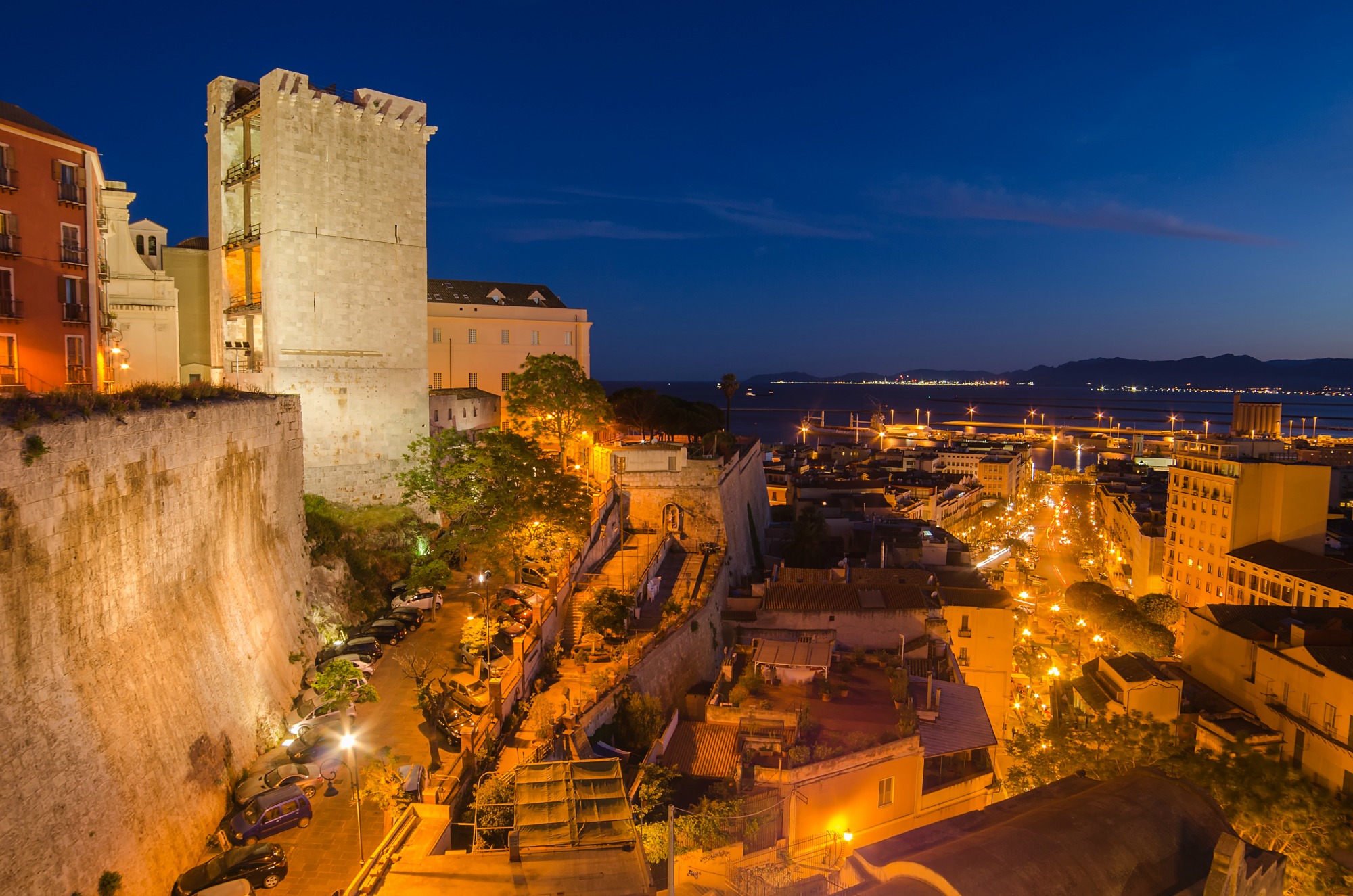
Fortifications of Cagliari
Cagliari's walls run all around the perimeter of the ancient Castello district and include the tower of the Elephant and that of San Pancrazio. Large parts of the old system of towers and bastions, built to protect the town, are still remaining and today, thanks to the panoramic views of the town they offer, you can spend pleasant, relaxing moments. From elegant terraces, in one of Cagliari’s highest areas, you can sip an aperitif while enjoying the breathtaking views. Not far from the fortifications, you will find the main shopping streets.
Between 1491 and 1508, a bastion was built on the hill of the Castello district and was the seat of the town's civil and religious authorities for centuries. In 1534, a boundary wall was built between the Tower of the Elephant and the Church of Santa Croce, a former synagogue converted into a Catholic place of worship in 1492. The Bastion of Santa Croce is now an elegant terrace, an elegant terrace and centre of nightlife, overlooking the Stampace district and facing the deep blue sea of the port.
The Tower of San Pancrazio, built in 1305 by architect Giovanni Capula, was constructed in sandstone, white limestone extracted from the Bonaria hill, where the splendid basilica of the same name stands. At the base of the tower, the gate of San Pancrazio opens up, allowing you to enter the Castello district.
The Tower of the Elephant was built two years later. Its name comes from the statue of the pachyderm, symbol of the city, positioned on a corbel on the external part, facing towards the port. Divided into four levels, you will be struck by the majesty of the great portcullis which is raised, but ready to close the entrance door to the old district. Don't be afraid to cross it, though, because it is now one of the access routesalways open (and highly-frequented) to the beautiful sights of Cagliari.

Armungia
It stands on a plateau surrounded by woods, Mediterranean scrub and cultivated fields in the historical territory of Gerrei. From a portion of the territory of Armungia, known as Cilixiucci, you can enjoy a view of incomparable beauty over the whole valley from the Flumendosa, the second longest river in Sardinia (and the one with the greatest flow). The historic centre developed around the nuraghe Armungia, which gives the village its name and dates back to the 15th-14th century BC. Today, it is in a good state of preservation, located right in the centre of the village, and it is one of the rare cases of a town-based nuraghe. The archaeological area includes a tower made of limestone blocks that has a twelve-metre diameter, with an internal chamber more than eight metres high and covered by a tholos (false dome). A flight of steps on the left of the entrance led to the terrace.
The village architecture reflects the agro-pastoral origin of the village: modest houses made of schist, inside which you will often find a ball oven and courtyards with rooms used as storehouses or stables. The town is a true scattered museum, meaning a system of museums and monuments that bear witness to the culture and everyday life of the village. When crossing the quaint village streets, you will be following an itinerary of great cultural interest. From the nuraghe Armungia, which is softly lit up in the evening, you will pass by the ethnographic museum of sa Domu de is Ainas, located inside the municipal building, in which there are about six hundred artefacts from the material culture of the local farming community, then the Bottega del Fabbro (Blacksmith’s Workshop), a stone building dating back to the early nineteenth century that contains the tools of the ferreri, and lastly the house of Emilio Lussu, a museum dedicated to the great writer and statesman, who was deeply linked to his village of birth, and to his wife Joyce Salvadori Lussu, both protagonists of twentieth-century history and key figures in the democratic and antifascist history of Italy.
Around Armungia, you can also admire numerous caves, like those of su Pittiolu and Gospuru, as well as a few abandoned mines, which offer you an interesting itinerary of industrial archaeology. The territory is on the border of the Park of Sette Fratelli (Seven Brothers): you can lose yourself in the lush, enchanting nature, particularly appreciated by trekking lovers.

Sassari
Founded in the Middle Ages, when the population of the ancient Turris Libisonis gradually took refuge in the hinterland, Sassari emerged on a limestone plateau marked by valleys and gorges and surrounded by cultivated hills. Olive groves and woods complete the setting of the fifth largest territory in Italy. It is the city with the second biggest population in Sardinia (128 thousand inhabitants), the heart of an area that contains double this number. It became a Municipality in 1294, with the promulgation of the Statutes of Sassari, which represent a fundamental body of laws in the history of the Island. In the 19th century, it expanded beyond the fourteenth-century walls that surrounded it, linked by 36 towers. Six of them still remain. The La Marmora barracks were built in place of the castle, now the museum of the Sassari Brigade, protagonist of military events in the 20th century. The most influential Sassari-born people include former politician Enrico Berlinguer and former Italian presidents Antonio Segni and Francesco Cossiga. The Fontana di Rosello fountain and Piazza d'Italia are the two symbols of the city. The city centre consists of stately buildings and places of art and culture. There are numerous museums, among which the Mus’A, the Biasi, the Tavolara Pavillion and, above all the Sanna National Museum, a powerhouse of archaeology. The most impressive prehistoric (and mysterious) piece of evidence is the altar of Monte d’Accoddi, a step pyramid that brings to mind the sanctuaries of Mesopotamia, built in the 4th millennium BC, renovated in the 3rd millennium and frequented up until the Bronze Age. In the Sassari area, there are also dolmens, domus de Janas, menhirs and 150 Nuragic sites with nuraghi, villages, Tombs of Giants and sacred wells. The most ancient of the religious buildings is the church of Sant’Apollinare. The cathedral of San Nicola di Bari stands out and is a harmonious overlapping of architectural styles (Gothic vaults, Baroque façade, classical decorations), built starting in the 13th century. On the second last Sunday in May, the captivating Cavalcata Sarda, a parade of traditional costumes, takes place. On the 15 August ‘Ferragosto’ holiday, the ‘big’ festivity is celebrated, that of the Discesa dei Candelieri, a procession of monumental wooden candles carried on shoulders along the streets to the church of Santa Maria di Betlem, to renew the vows made to the Virgin Mary who, according to legend, saved the town from the plague. The Holy Week rituals are also very evocative. On the subject of tradition, there are also the local dishes: ‘favata’ (broad bean stew) and ‘monzette’, little snails cooked in batter. There is no lack of gardens and parks, among which the park of Monserrato a green oasis. Platamona, a stretch of sand in the gulf of Asinara, is historically ‘the beach of the people of Sassari’. On the western side, to the north of Capo Caccia, you will find the dazzling colours of Porto Ferro, with its fine sand, and Porto Palmas, with its small smooth pebbles. Further north, there is the Argentiera, an evocative symbol of mining archaeology, once in vogue and today a ghost village.