
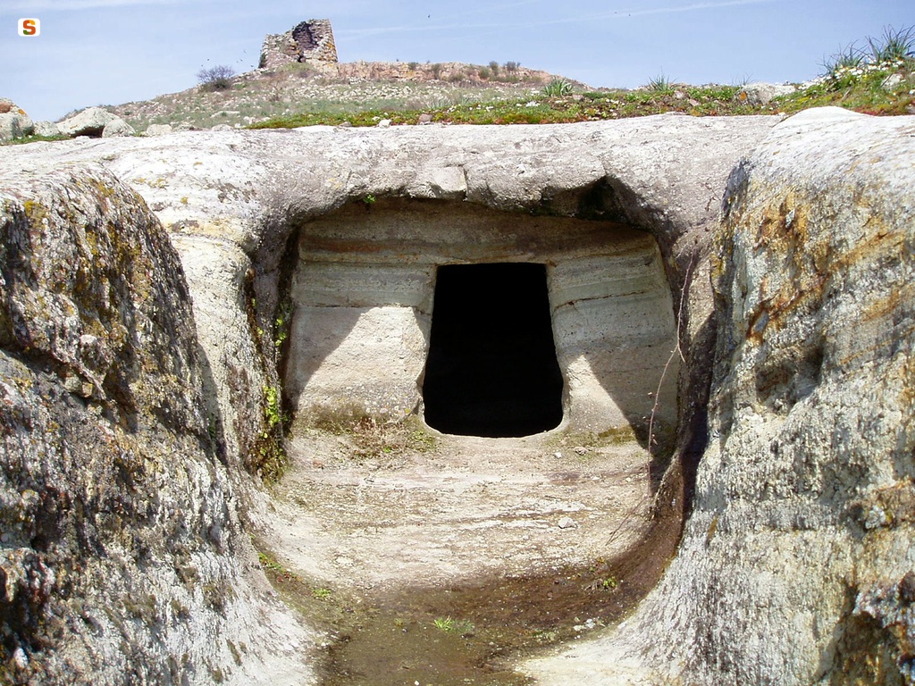
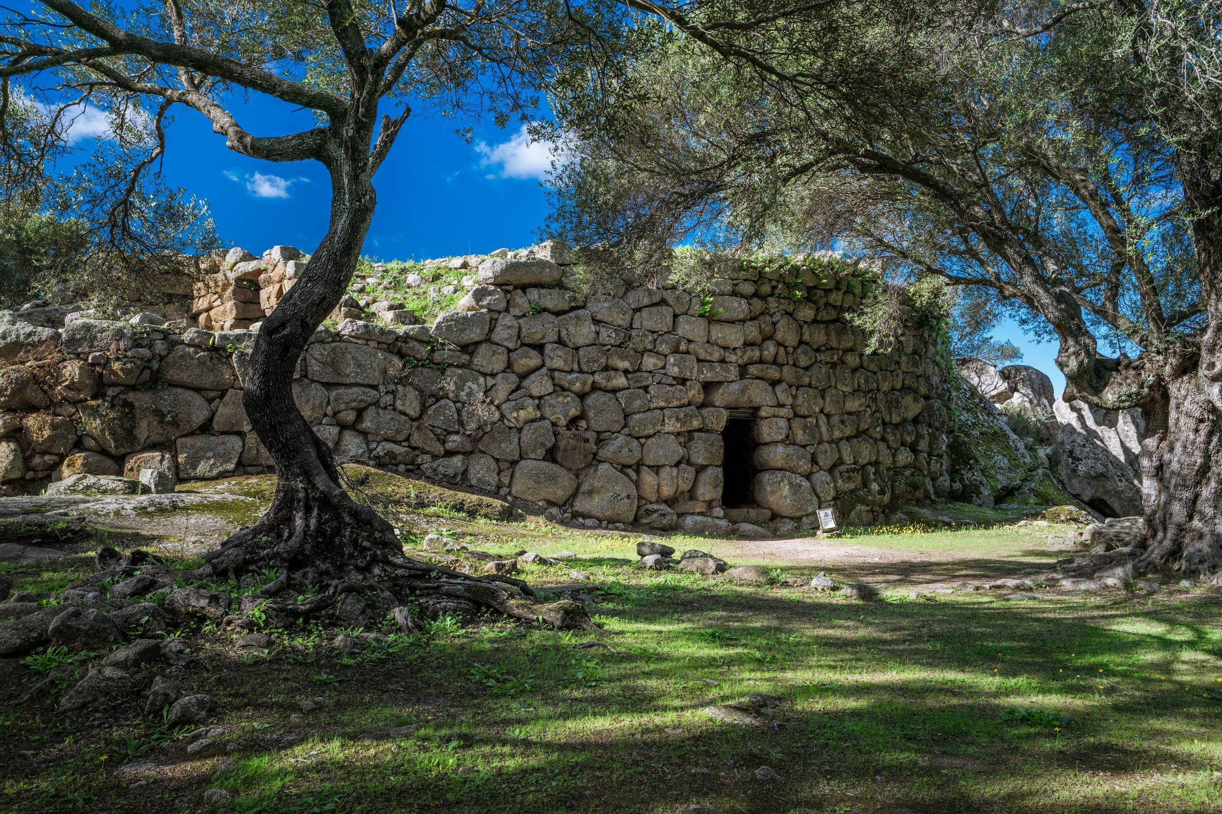
Necropolis of Filigosa
Their peculiar shape gives an anthropomorphic appearance to the rock, almost as if it were watching over the extraordinary testimonies of the remote past with a severe countenance. The four domus de Janas of the Filigosa necropolis rise at the foot and on the slopes of a hill topped by the imposing tower - 13 meters in diameter - of the Ruiu nuraghe. The pre-nuragic burial ground is a few kilometres from Macomer, the main centre of the Marghine, and is closely linked to that of Abealzu, in the territory of Osilo. Although they are 60 kilometres apart, the two sites, Macomerese and Osilese, have architectural similarities, in terms of type of burials and identical finds: from the two necropolis derives the name of an important cultural facies of the Sardinian Eneolithic, the culture of Abealzu - Filigosa - also known only as Filigosa -, developed between 2700 and 2400 BC
Four tombs have been investigated so far: three dug into the tufa at the foot of the hill, and the fourth to a higher level, although the original the number of burials had to be much higher. All are multicellular, characterised by long access dromos (corridors) that follow the natural inclination of the rock and have circular hearth cells in the centre of the floor. The necropolis was used by the proto-Sardinian populations up to the first centuries of the II millennium BC, with funeral rites that provided for scarification and burial of the remains in secondary deposition (not in physiological position). The dromos of tomb I, eleven meters long, leads to the trapezoidal main compartment: at the base of one of its southern walls you will notice a funeral bed and, higher up, two hemispherical cups. At the centre of the floor stands a hearth of one meter in diameter with an annular edge in relief and central dip. Two doors in the back wall lead to six secondary cells. The first leads into a polygonal space and from this to another rectangular area; the other door gives access to four compartments arranged in pairs, one of which is in turn divided into two parts by a 'partition'. The dromos of tomb II has an initial curvilinear development, a trapezoidal major cell and other three square rooms connected in horizontal succession. The main cell, with a sloping ceiling towards the entrance, presents the 'classic' ritual fireplace and niche on a wall. The corridor of the third tomb, ten meters long, grows in height and width towards the bottom, covered in the final stretch by a small pavilion. The door with negative frame of the back wall leads into two coaxial square rooms. Tomb IV also has a corridor followed by three coaxial and square cells - with fireplace, cup marks and small niche - while a fourth side compartment opens onto the second room.
Of great interest is the reuse of the first tomb in the Nuragic age, with the restructuring of the dromos prospect with well-shaped ashlars, almost simulating the entrance of a Giants' tomb. The excavations have also brought to light a half-metre deep well, full of ceramics and Roman fictile objects of the Republican and Imperial ages. Macomer, not by chance, is identified with Macopsissa, the first Punic and then Roman city, cited by the geographer Ptolemy (2nd century AD), a strategic place of passage between the south and north of the island. Traces of streets and milestones remain.
In addition to Filigosa, among the prenuragic funerary complexes, Perdas de Tamuli stands out. The Macomerese territory shows traces of settlement dating back to the Upper Palaeolithic period, in particular in the Marras cave, where a statue of the Mother Goddess ('Venus of Macomer') was found, kept in the national archaeological museum of Cagliari. Among the nuragic testimonies, in addition to Ruju that dominates the necropolis of Filigosa, the most impressive and famous is the nuraghe of Santa Barbara, consisting of a 15 meter high central tower, a four-tower bastion and a large village. The Giants’ tomb of Puttu 'e Oes is also worth a visit.
Paulilatino
Surrounded by cork oaks, Mediterranean shrubs, olive groves and vineyards, and irrigated by springs, it sits in the south of the basaltic plateau of Abbasanta. Paulilatino, the biggest town of Guilcer in the Medieval period, has 2300 inhabitants, offers uncontaminated scenery and is famous for its prehistoric sites: Domus de Janas, dolmen, menhir and as many as 110 Nuragic sites. The most important of these is the Temple of Santa Cristiana (12-8th century BC), the best preserved and fascinating example of Nuragic holy architecture. It stands in a park with hundred-year-old olive trees that takes its name from the 11th century country Church of Santa Cristina. The Well Temple, surrounded by a fence shaped like a lock, has a vestibule and staircase covered by architraves and a chamber with a tholos vault. Water enters the pool through a year-round spring. Outside the fence, there is a meeting shed and a dozen or so other buildings, possibly housing for priests and market stalls. Two hundred metres away, stands the Santa Cristina Nuraghe, six meters high and thirteen wide. Sheds occupied from Nuragic age to the Medieval lean against the structure. Other must-see nuraghes include Battizzonis with a keep, bastion and three towers, and Lugherras. Built between the middle and the end of the Bronze age, it has a central tower surrounded by a three-lobed bastion, which is surrounded in its turn by an external wall with four towers. Nearby, there is a Giant’s Tomb with rare four-cornered stele. During the Punic-Roman period, a temple dedicated to Demeter and Kore was built on the summit of the nuraghe. Excavations brought to light various votive oil lamps (lugherras), for which the site was named. The most important Giant’s Tombs are those of Goronna. One of these, at 25 metres long, is among the biggest of the island. The “block-type” Mura Cuada Tomb is also interesting.
Paulilatino’s main income is from shepherding, which produces excellent cheeses: caciotta, sweet paulese and musinau (a type of sheep milk cheese). Ancient knowledge possessed by the locals is related to weaving and bread baking, for normal days (su coccoi de tzicchi) and for the holidays (su lazzaru). You can learn about local traditions at the Ethnographic Museum hosted at the Atzori mansion: the life of a community of shepherds and farmers is portrayed through old furniture and work tools. During the Roman era, to which the tombs of Muriscoa and the ruins of Putzu ‘e Turru have been attributed, the village was called Paulis Lactea. The name derives from a nearby bog, drained in 1827, which in the spring formed a milky film, latina in Lugodorese. Low, black basalt houses with ‘Aragonian’ doorways and wrought iron balconies, give the town a fairy-tale feel. The main square is called Su Pangulieri, meaning market stalls or the place were outlaws were punished. Here stands Su Cantaru Mannu, a large fountain fed by the Sa Bubulica spring. Many other springs powered mills until mid-20th century. In the town centre stands the 16th century Parish of San Teodoro built in the Catalan Gothic style with a façade embellished by a rose window and a bell tower with an onion dome. Other religious buildings include the 17th century churches of Anime and of Santa Maria Maddalena, in honour of which the most popular celebration is held in late July, the 16th century cemetery Church of San Sebastiano and the Church of Nostra Signora d’Itria, whose feast day is celebrated after the Pentecost with a procession in traditional dress and sacred songs, is goccius.

Spargi
Uninhabited because of its granitic and rugged nature, it has an almost circular shape, with few coves and countless sandy bays. Spargi is located across the western coasts of the Maddalena, and is the third largest island of the Maddalena Archipelago National Park, with a surface of over four square kilometres. It is accompanied by its “smaller sister”, Spargiotto, where rare bird species nest: European shags, Audouin’s gulls and European storm petrels. Not too far west rises the Spartigiotello cliff and its shallows, split in half by a sand channel, a paradise for divers. The seabed is surprising: large underwater attractions include the Washington shallows, Punta Zanotto, coloured red by soft corals, and Spargi wreck, a Roman craft (35 metres long) dated 2nd century BC, discovered in 1939. Part of its load is in exhibition at the Nino Lamboglia Museum in the Maddalena.
To reach the island and islet, take private or rented boats or go on a guided excursion leaving from the Emerald Coast, La Maddalena, Palau and Santa Teresa Gallura. Sgargi is particularly beautiful from its southern and eastern sides, where there are beaches of white sand: the turquoise reflections of Cala Corsara, the crystalline luminosity of Cala Soraya, Cala Conneri (also called Cala dell’Amore) and Cala Granara. Little coves lined with rocks sculpted by time and vegetation that grows all the way down to the shoreline are abundant in the north (Cala Pietranera) and west (Cara Piscioli). The hinterland is almost impossible to access, covered in cistus, giant strawberry trees, juniper trees and mastics. In the early 19th century, a famous episode confirmed this particularity: Natale Berretta hid here to avoid being arrested, and managed to elude inspections. Once he was proved innocent, he decided to continue living there with his family.
In the 20th century, the island was a military base during both world wars. Today its fortified bases are local attractions: in particular, Fort Zanotti is located on its northern part, overhanging the sea, hidden among granite and vegetation. The old military port of Cala Granu and other former military seats are in the northwest of the island.
Santa Maria
The pearl of the far north of Sardinia, the closest to the Strait of Bonifacio, on the border with Corsica. Together with the two other splendid islets of Razzoli and Budelli, Santa Maria represents the northernmost part of the La Maddalena Archipelago Park, one of the destinations not to be missed on your tour of about 60 islands. The surface area of the islet is two square kilometres, while it has a ten-kilometre perimeter of jagged coastline. The characteristic that makes it stand out from the other minor islands of the Maddalena Archipelago, is that it is the only one that is permanently inhabited, obviously apart from the big ‘sister’ La Maddalena. You can reach it in about twenty minutes by boat from the port of La Maddalena or that of Palau.
The morphology of Santa Maria also distinguishes it from the nearby islands: it has no elevations and the highest point is Guardia del Turco, just 49 metres high. So you can walk through nature, crossing paths surrounded by low Mediterranean scrub. Along the ‘internal’ paths, you will come across the ruins of a Benedictine monastery built in the first half of the 11th century and a place of seclusion and prayer for the monks. It was abandoned in the 16th century and at the end of the 18th it passed to the Bertoleoni family, who later also took possession of the beautiful Spargi. In the 19th century, the renovated building became a shepherd’s dwelling. Today, other homes are present on Santa Maria and are also used as summer residences by artists and show business celebrities.
Along another scenic path, you will reach the lighthouse of Punta Filetto, where you can enjoy the view that extends across the open sea to some smaller islets. From the lighthouse, you will catch sight of some coastal pearls, particularly the coves of Cala Santa Maria and Cala di Fosso. The first, which can be reached by sea, has very fine white sand, washed by the uncontaminated sea and with an abundance of marine animals. It is 200 metres long, making it the biggest beach of the entire archipelago. Its shallow waters and sandy seabed sloping down towards the open sea form a splendid natural pool. The cove is surrounded by pink-coloured rocks covered in Mediterranean greenery. Behind the bay, there is a small saltwater lake, the Palude, habitat of numerous species of aquatic birds: woodcocks, moorhens and mallards.
From Santa Maria, you can easily get to the adjacent Razzoli, ‘walking on the sea’ along the Passo degli Asinelli (Passage of the Donkeys), a strip of sand submerged by just half a metre of water. Further north, you will come across the narrower Passo dello Strangolato (Passage of the Strangled one) that separates Santa Maria from the islet of La Presa, which represents the northernmost point of Sardinia. On the island, you will find bathing facilities, hotels and restaurants where you can taste seafood cuisine, as well as authorised charter services for visiting the entire park, including the brightest jewel, the Spiaggia Rosa (Pink Beach), or for doing some fishing tourism or using the services for open sea diving.

Domusnovas
It is located in the valley of the Cixerri river, in a largely mountainous territory. Domus novas, with over six thousand inhabitants, is an important municipality in the Iglesiente area and is known as the 'village of the grottoes' as well as being a protagonist in the historic mining period, which lasted over a year, until the middle of the 20th century, with approximately 50 mines, among which Arenas, Barraxiutta, Sa Duchessa and Tiny. As well as the abandoned sites, you can also visit the city museums: the Mineralogical Museum located in the former Monte Granatico with collections of minerals and fossils, and the Museum of Wildlife and Nature. Evidence of the extraction activities are also kept in the vast complex of Monte Linas-Oridda-Marganai, a park with varied landscapes: from the granite Mount Linas and the limestone massif of Marganai to the Plateau of Oridda, where the forest of Montimannu is situated. In the granitic areas you will come across gorges and waterfalls, like Piscina Irgas and you will find holm oak forests on the elevations, which you can travel through on foot or on horseback.
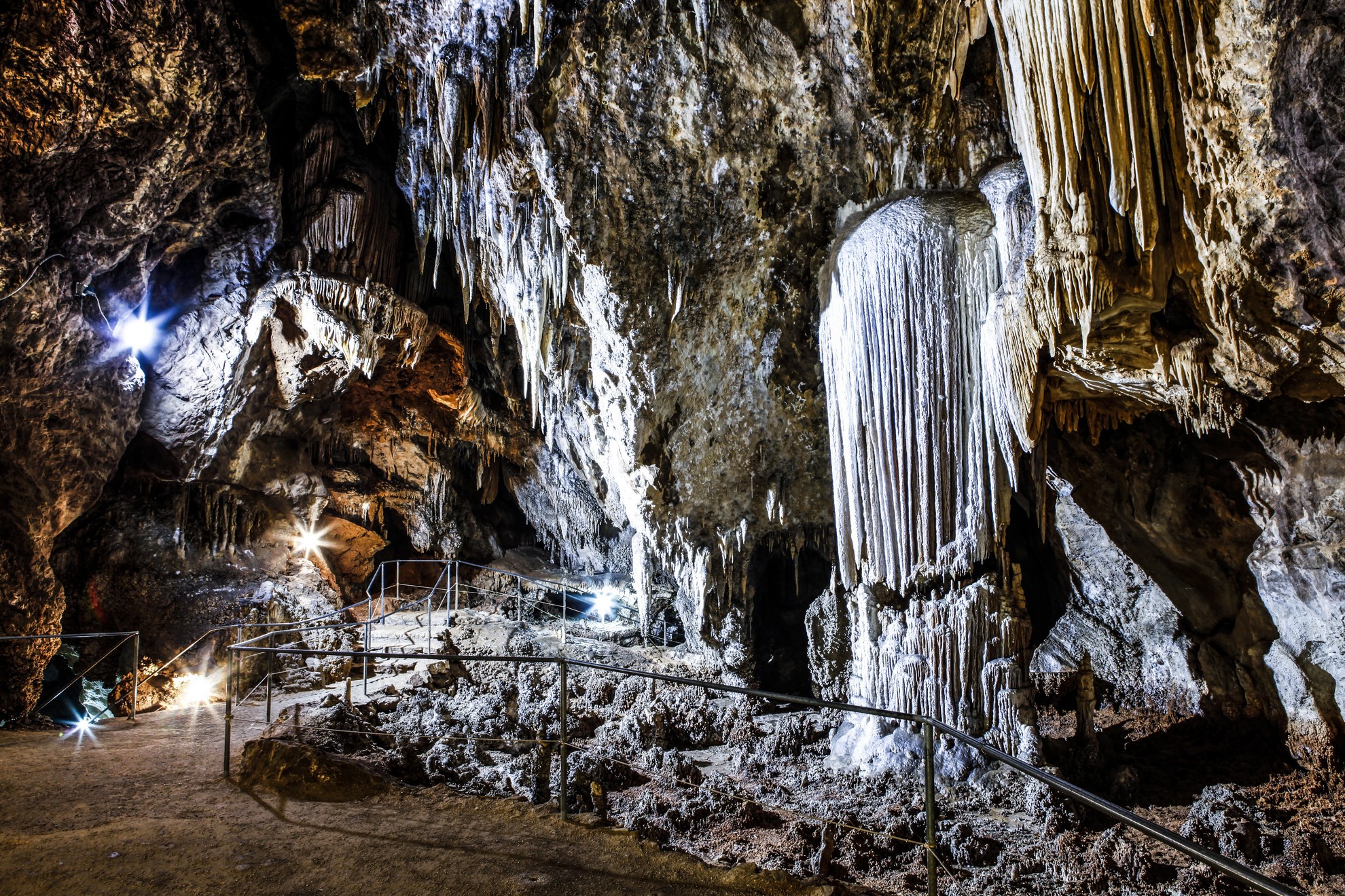
Infiltrations have created underground rivers and caves in the limestone rocks, among which the Abisso Paradiso grotto and a famous 'geological gem', namely the Grotto of San Giovanni, that runs from one side to the other of Mount Aqua. A well-lit winding through road runs through it: it is the only one in Italy and a rarity in the world. It is divided into two levels: a fossilised part, 850 metres long, consisting of large rooms with stalactites and stalagmites, and an active part, two kilometres long, extending through tunnels and underground passages. The rock faces at its entrances and the cliffs of Oridda are ideal for rock climbing. The residential area is three kilometres from the southern entrance: along the road, you can admire the old mill of Sa Ferraia and the little church of San Giovanni. It was built amidst centuries-old olive trees, following the demolition of the chapel dedicated to the saint inside the grotto, around 1800. The other buildings of worship are located in the old town centre: the medieval church of Santa Barbara and the parish church of the Vergine Assunta, dating back to the 18th century, with a stone façade. The festivity in her honour takes place on the 15 August Ferragosto holiday, with folk group processions and launeddas players. At the northern and southern entrances of the Grotto of San Giovanni, there are the remains of gigantic walls, which remained intact until the 19th century and are one of the most majestic pieces of prehistoric evidence in the area. The Nuragic era left behind obvious signs: the most important is Sa Domu e S’Orku, with a central tower and bastion surrounded by a wall intercalated by five other towers. Domus novas has medieval origins. The Pisan and Spanish dominations left a permanent mark on its traditions, particularly on the rituals of Holy Week and Friday is the day on which they are richest in pathos, with the procession of the Crucifix and Su Scravamentu. Among the lay festivities, don't miss the various stages of Primavera Sulcitana (Spring in Sulcis) and Sapori d'Autunno (Flavours of Autumn).
Is Zuddas
In a magical environment, made of rock and fantasy, you become a child again. The grottoes of Is Zuddas, in the territory of Santadi, open up 236 metres below sea level in the cambrian limestone, dating back to 530 million years ago, of Monte Meana. They extend over a total of 1650 metres, while the visitable tourist itinerary is half a kilometre long. Each of the rooms stands out for its size and the variety of concretions covering cavities and walls: from stalactites, stalagmites, flows and tubular formations to aragonites, symbol of the caves, the formation of which is still a mystery and is the object of research.
Just past the entrance, look up at the ceiling, where you will see the tracks of the Prolagus sardus, a now-extinct rodent that existed only in Sardinia and Corsica. The Organ room is one of the most evocative rooms. Its name derives from a column of stalactites and stalagmites, resembling a pipe organ, embellished by formations of various shapes. After a short tunnel, the impressive Theatre room opens up before you and is a prelude to the Eccentrics room, adorned with aragonites, unique thread-like formations unlike any others in the world, which have developed in all directions without being influenced by gravity, often taking on bizarre shapes. Next to these are the acicular aragonites: large tufts of crystals similar to needles, known as 'cave flowers'.
A visit during the Christmas season is even more exciting: in the Organ room, you will be able to admire a charming nativity scene, enriched by trachyte sculptures created by the sculptor Giovanni Salidu. Nearby, there are other evocative caves: Pirosu, inside which a Nuragic sanctuary was found, and those of the Campanaccio (Cowbell) and the Capra (Goat).

Nuragic village of Tiscali
It is located in a deep depression created by a deepening in the heart of the mount of the same name, in the boundary between Supramonte di Oliena and Supramonte di Dorgali. The Nuragic village of Tiscali, built along the walls of the depression and invisible until you get to the inside of the cavity, consists of two ensembles of dwellings of various sizes, built and inhabited between the 15th and 8th centuries BC. Their origins are mysterious: the building technique is different from those of other Nuragic sites. It was probably inhabited in pre-Nuragic ages. What we do know is that it was repopulated between the 2nd and 1st centuries BC, and inhabited for a very long time, perhaps up to the High Middle-Ages.
You will reach the first agglomerate by means of a wide opening in the rocky wall. To the north, forty circular stone huts are built over a cliff, which probably indicates there were once terraces, which later collapsed. The second complex is located on the southwestern side, and consists of about thirty square or rectangular dwellings. In the centre of the cavity, you can admire a millennial grove of holm oaks and mastic trees. Their particular location and water collection system point to the probability that inhabitants stayed in the depression for long periods of time. The village was perhaps the extreme defence system against invaders in the Roman age.
Tiscali is one of the most popular trekking destinations in Sardinia. To reach the depression, in the centre of which a wide window opens with a view of the Lanaittu valley below, you must first face two hours of intense trekking. Thanks to the wild scenario, the path to discover a valley hidden in the entrails of the island becomes very interesting. Arriving from Dorgali, the path, marked with road signs and arrows on the rocks, crosses the Surtana valley and the Doloverre gorge until it climbs mount Tiscali. The Dorgali and Oliena territories are an archaeological park. Another unmissable village-sanctuary is Serra Orrios, which consists of about one hundred huts, two small temples and megalithic tombs, the Arvu complex, the Carros foundry, in addition to tens of domus de Janas, menhirs, Giants’ tombs and other Nuraghi, including Mannu, which dominates a basaltic geography in the centre of the Gulf of Orosei. The Corbeddu and Ispinigoli grottoes have yielded human traces dated all the way to the Palaeolithic. To complete your archaeological tour, go to the Civico Museo Archeologico of Dorgali, dedicated to findings from all over the territory.
Nuraghe Albucciu
A walk through the countryside of Arzachena, the renowned tourist centre of Gallura, will allow you to discover a landscape made of vineyards and pastures, in an area that has been inhabited for millennia and which preserves a rich archaeological heritage inherited from the civilizations that populated the area in prehistoric times. Just two and a half kilometres away from the village of Arzachena, you will find the Albucciu nuraghe , one of the most characteristic and important examples of a 'corridor' building (or protonuraghe), the ancestor of the later nuraghes, although the truncated-ogival rooves were affected by the subsequent tholos building technique .
Dating back to the Middle Bronze Age (15th century BC), the centuries, or rather the millennia, have meant that the nuraghe is completely hidden in a jagged grove of olive trees and Mediterranean scrub. The peculiarity, which differentiates it from the other nuraghes in the area, is its construction technique. The imposing granite blocks were carefully leant against an imposing, light-coloured granite rock that forms part of the masonry of the main building, as well as a preponderant part of the entire nuraghe.
The structure is very well preserved despite some collapses. The layout is irregular, typical of protonuraghes. The shape is rectangular with a north-south orientation and east-facing façade. At the entrance, surmounted by an architrave and open on the large façade, you will see, on the left, a deep closet and a large elliptical room covered with tholos on the right. You will also notice a series of corbels that, in the past, held a balustrade to protect the terrace. Past the entrance, you will see two small niches, one on each side. Further in, you will find a trapezoid passageway, and if you look up you can see a false dome ceiling. On the southern slope is the largest space on the ground floor. The very high roof allowed for a wooden loft that divided the hall into two floors. In the lower one, a mullioned window opens on one side, while a seat on the floor near the fireplace and a wall cupboard still give the nuraghe the impression of 'being lived in'. The upper floor is one of the largest rooms in the entire building: you will enter it via a staircase. It consists of a semi-circular open-air area and a series of rooms, including a large circular chamber, the largest of the nuraghe, accessible only from the terrace. The main daily activities took place on the upper floor: processing of milk and cereals, cooking bread and other foods.
Among the most important findings at the site are a hilted dagger, a statuette of an offeror and a closet of bronzes. These objects allow us to date the Albucciu nuraghe to between the end of the Middle Bronze Age and the Iron Age (around 1400-650 BC). The archaeological area, in addition to the nuraghe, also includes the remains of circular huts, which formed the nuragic village, and 80 meters from the complex the remains of a Giants' tomb called the Moro tomb, probably connected to the life of ' Albucciu. Not far away there is also the Nuragic temple of Malchittu.
San Pietro - Villamar
Romanesque churches with two apses are a rarity in Sardinia and the Church of San Pietro is an exceptional case within this originality, perhaps because its double apse was not envisaged in the original building. The sanctuary is located in the historic centre of Villamar, on the edge of the Majorcan district, an area ‘colonised’ in the 14th century by grain traders from the Balearic Islands. There are no sources that attest to the construction phases, but it is thought that the church was built, with a single nave, in the second half of the 13th century. Later on, a decision was made to expand it to the north by adding a second smaller nave. Both naves end with an apse, but the second has a smaller diameter and is not as deep. It is possible that the work was carried out by different workers and that, when constructing the north nave and the double bell gable, the builders tried to imitate the style of their predecessors. Some decorative motifs, such as the pointed arches on the façade, bring to mind Arab influences, suggesting that masters from Spain worked on the construction site.
The sanctuary, built in sandstone and vulcanite, rests on a high plinth, from which you will see corner pilasters and pilaster strips that start in the façade and divide it into sections. The corbels of the arches are decorated with a variety of ornamental motifs: crosses, flowers, pointed leaves and human protomes. Each of the two naves has its own entrance portal. Inside, they are separated by three large arches resting on rectangular-section pillars. The roofing is made of wood, while the floor retains its original stone construction. You can admire several wooden sculptures, including one depicting the saint to whom the church is dedicated in pontifical robes, gilded and damask, dating back to the late 16th and early 17th centuries. Just over two hundred metres separate San Pietro from the parish church dedicated to Saint John the Baptist, constructed on a pre-existing Romanesque building and the result of Gothic-Catalan renovation carried out in the 16th century. The parish church is the place where the Retable of the Madonna del Latte (the Nursing Madonna) is kept, one of the main works by the painter Pietro Cavaro, made up of various panels depicting scenes from the life of Jesus, Mary, apostles and saints. A short distance away, you can also visit the sixteenth-century Church of Madonna di Antoccia, which contains several multicoloured statues created using the cannuga technique, meaning with the body made of a frame of canes. Outside the residential area, in the middle of a park, stands the small Church of Santa Maria d'Itria. Every year, on the third Sunday of August, the people of Villamare come here in a procession, accompanying the statue of the Virgin Mary and celebrating a festival that is particularly heartfelt by the community.
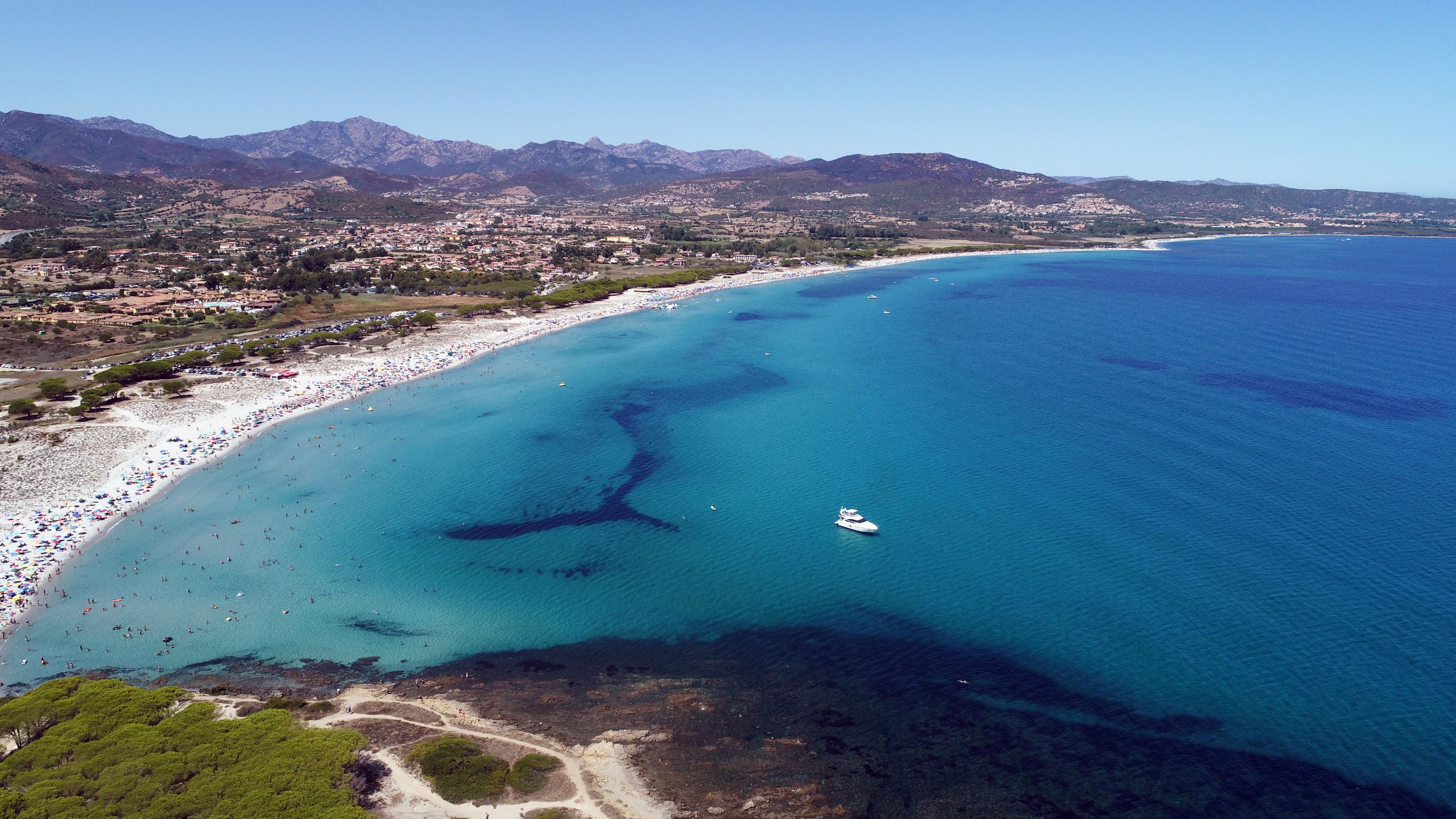
Cala di Budoni
A seaside little town rich with charm, night life, history and traditions, Budoni, a Gallura commune in the border with Baronìa, could not but boast among its pearls a string of dreamlike beaches. Cala di Budoni is, without a doubt, a shining example. About four kilometres long, it goes from Li Cucutti to Porto Ainu, and overlooks a crystalline, shallow sea, perfect for children, with fine and light sand. Along its long and sinuous extension, the coast of Cala di Budoni changes name a few times: Li Salineddi, Salamaghe, Lido del Sole and sa Capannizza.
The beach offers plenty of comforts and services: it is accessible to disabled people and has plenty of parking space. The whole area has many hotels and camping sites, as well as cafés and restaurants. You can also rent beach equipment. The cala is loved by windsurfers, scuba divers and snorkelers.
Nearby, the natural habitat is very varied. The Mediterranean scrub, growing in the midst of the sand, follows the shore and enriches it with green hues. This spectacular scenario also has small dunes, ponds and pine groves, the home of many different species of birds. In the Budoni territory, you will also get to know other pearls of these shores: Li Cucutti, “hills” in Gallura dialect, like those covered in lush green pine groves around the wide beach that meets the turquoise sea; the beautiful yet never crowded beach of Baia Sant’Anna, made of thick golden sand and lapped by crystalline green seawater that becomes deep after only a few steps away from the shore, and cala Ottiolu, near the small Porto Ottiolu neighbourhood, a fantastic beach of white sand that enters the crystalline sea, much beloved and very popular.