
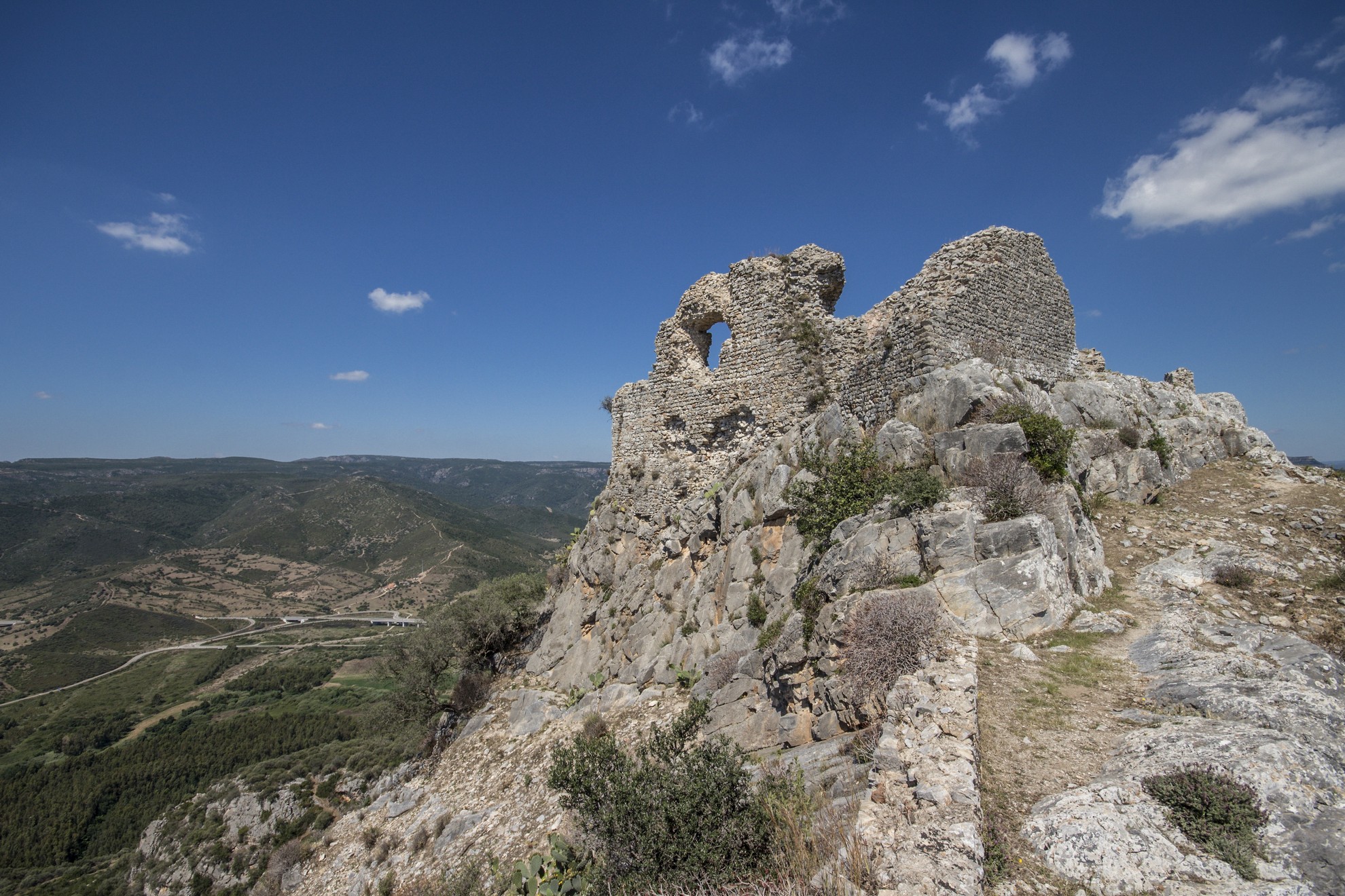
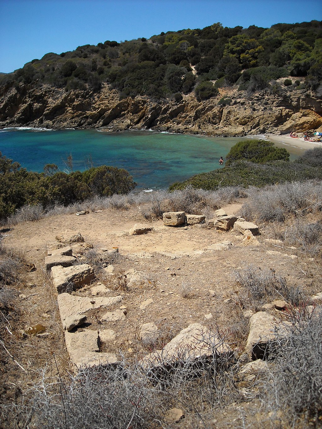
Castle of Quirra
To get to the Castle of Quirra, you'll have to take a stretch of the 'old' SS 125, the Sardinian Orientale so popular with bikers, and you'll think that 'the journey is as good as the destination'. Then you'll walk for twenty minutes along an arduous path until you reach its mighty walls besieged by wildlife. Finally, from up there, the view of Cala Murtas and Porto Corallo on one side and the Ogliastra Tacchi on the other, will remain etched in your memory for a long time.
Today, the Salto di Quirra testing range is part of the municipality of Villaputzu, a transitional territory between Sarrabus and Ogliastra. In the 12th century, when the judges of Cagliari built the castle on the hill of Cudias, it marked the border with the judicature of Gallura. The manor then passed to the Pisans and finally to the Crown of Aragon, which awarded it to the powerful Carroz family as compensation for their support during the wars of expansion. The castle of Cagliari and other fiefdoms in southern Sardinia also went to the Valencian nobles.
During the Spanish domination, the castle was the stronghold of the Marquisate of Ogliastra, a powerful and prosperous fiefdom that stretched from Tertenia to Santa Maria Navarrese and comprised 76 villages. Its castle must have been imposing and appeared impregnable, and it is still possible to see its large perimeter and walled enclosure with towers and two cisterns. From the top, you only have to look around to understand why the area was fiercely contested in the Middle Ages: its location was strategic for monitoring the coast and the access routes to the inland mines.
The fate of the fiefdoms and castles given to the Carroz family marked the life of Violante, who, at a very young age, was appointed to inherit the Ogliastra fiefdom after the death of her father during the fire in Cagliari castle. She was the last heir of the immense family fortune. Left alone and at the mercy of her relatives who tried to undermine her, she was able to impose her will and rule the fiefdom in spite of the family's wiles and also of the local Church, which condemned her for her extramarital affairs. The parish priest who dared to challenge her lifestyle was hanged and his body displayed as a warning in the castle grates. For this violent act, she was nicknamed the Bloody Woman and removed from the island she loved.
This is the story so far, but the legends about her are endless: one concerns the love of the Count of Mandas who wanted to marry her and take her with him. Violante demanded a condition that he considered impossible to fulfil: to reach the impassable castle of Quirra with a four-horse coach. The Count succeeded and took Violante away from her fortress, but the pain of leaving her homeland led to her death of a broken heart along the way. The mountain path they travelled today connects Quirra to Perdasdefogu, and in her honour and in memory of the sad tale is called sa Scala de sa Contissa. According to another legend, Violante Carroz died when she fell from her castle, leaving behind a golden loom hidden in one of the many caves on the slopes of the hill: many believed it was not a legend and searched for it, without ever finding it.
Castle of Chiaramonti
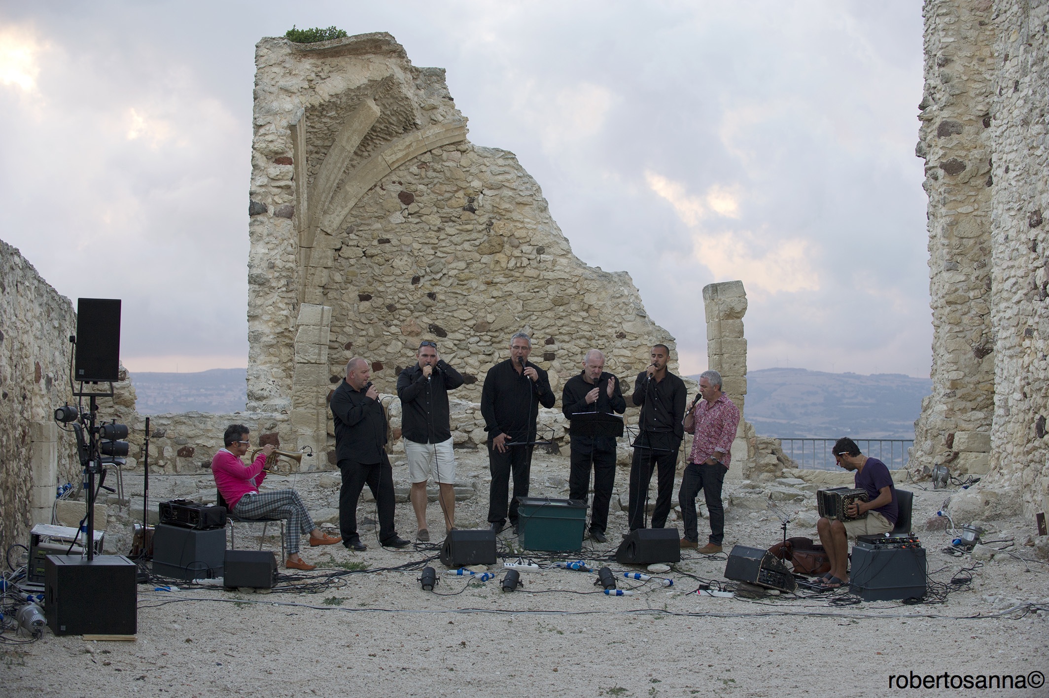
“At least 600 years old, on the top of a mountain, at the edge of a cliff, a quarter of an hour over steep and rugged trails,” were the few concise words that said it all. They were pronounced by the mayor of Chiaramonti in 1827 to justify and finalise the definitive abandon of the “uncomfortable” parish of San Matteo. It had been built around the beginning of the 16th century over the remains of the fortifications of a castle built by Brancaleone Doria, the husband of Eleonora d’Arborea. The imposing church on the fort had been repeatedly sacked by raiders, and so the mayor had a new parish church built in the centre of town.
The history of the grand manor has been forgotten, it is no longer a church and not even a fortress coveted by men greedy for power. It has now become an oasis of peace steeped in history, reachable on foot from the centre of Chiaramonti, an ancient little village in Anglona on the border with Sassari and Logudoro. Some parts of the old church are still standing and imperiously dominate the town, like the 12 metres high belfry built on the tower of what had been a medieval castle. Eight chapels lined the nave, of which traces of aragonese architecture are still visible in the vaulted ceilings, and at the side was the chapel of the convent of Carmelites that flanked the church.
In the silence of this abandoned church, you can almost hear the echoes of the bells in the tower as they set the rhythm for the pastoral life of the villagers, and, within the walls, hear the raised voices of the troops of the Doria family as they defend the castle from the power lust of rivals.
The mayor back in 1827 certainly couldn’t have imagined that the abandoned “falling fortress” would have become so fascinating as to attract visitors and cultural events in a then distant future. How could this place, so vital to the history of Chiaramonti, so rife with different and contrasting emotions, the powerful foundations of an unconquerable fort and walls steeped in devotion, not become an international stage for jazz musicians, so at home in this part of Sardinia?

Forum Traiani thermal baths
Ancient Rome's passion for thermal waters extended to the far reaches of their empire, and an important neighbouring province such as Sardinia could not be missed. On the island they built their main baths in Fordongianus, to capitalise on waters that rise to the surface very hot (at 54 degrees) while maintaining their beneficial properties.
However, the history of thermal baths here, as in many other island spas, is much older, dating back to prehistoric times: the pre-nuragic and nuragic Sardinians considered these waters sacred and used them to heal themselves. Sacred springs and wells probably attracted the early Sardinian populations from other island territories near and far. In fact, the plains around the town today are dotted with prehistoric settlements, including Casteddu ecciu and several domus de Janas necropolises.
The Roman thermal complex was built on the banks of the River Tirso, precisely on the site of Caddas (appropriately meaning 'hot') that the Romans called aquae ypsitanae. Emperor Trajan commissioned the establishment at the edge of the town centre of Forum Traiani, the great trading market between the Romanised populations of the hinterland behind the Gulf of Oristano and the communities of the north and south of the island. When the complex was built, the forum also became a place of wellbeing and a social gathering place, where people not only bathed in the pools but also strolled along the arcades around the pools discussing politics and business: Forum Traiani became a popular destination for cultivating physical and mental health and the pleasures of life. The architecture, with its arcades, halls and pools, is still impressive today and gives an idea of what it must have been like in the days of imperial Rome.
In the centre of the establishment is a large rectangular pool reserved for bathing in warm water (tepidarium), once covered with a barrel vault and surrounded by porticoes where people stopped and rested between baths. On either side are the catchment and mixing basins and the Nymphaeum, a large basin surrounded by niches where statues and votive plaques were displayed. This was the sacred space for the worship of the healing powers of the aquae calidae. More secluded is the thermal pool circuit, from the hot baths (calidaria) to the frigidarium with changing rooms and dining areas.
Private patrician houses, 'reception facilities' for visitors, public buildings for civil activities and funerary rites were built around the spa, most of which are now part of the subsoil of the town of Fordongianus, which shows signs of ancient remains in many parts of its urban grid. With the fall of the Roman Empire, the baths were gradually abandoned. The final blow came during the Middle Ages, when they were dismantled to build churches, convents and places of worship. The strictly therapeutic parts of the building were saved, along with a few others that escaped the new worldview, but were fortunate enough to continue the tradition of the thermal baths and still make the former Forum Traiani a wellness centre par excellence.
Nuraghe Aleri
It dominates the marina of Sarrala from the top of a hill with a view of the large, splendid Foxi Manna, in the same way it once guarded a port built next to the beach, at the mouth of a river. The Alèri, built around 3500 years ago, is the best-preserved nuraghe out of dozens discovered in the Tertenia territory. Ten kilometres separate the main town in southern Ogliastra from the archaeological site, which can be reached along the road that leads from the village, through Capo Sferracavallo, to its seafront. After parking your car, you can walk along a path through wild nature and evidence of the distant past.
It is a complex nuraghe of great visual impact, consisting of a central tower with a tholos roof, built at the beginning of the Middle Bronze Age (15th century BC), to which, over the centuries, until the 11th century BC, three other secondary towers were added, positioned on the sides and the front with respect to the keep, connected by straight curtain walls and internally linked by covered corridors. The origin of the building dating back to the archaic phase of the Nuragic age is confirmed by the use of unprocessed granite rocks, of various sizes, positioned in uneven rows.
Starting at the architraved entrance, there is a seven-metre-long corridor. Halfway along it, there is a stairwell, now blocked after various collapses, and there is a circular room at the end, with a diameter of four and a half metres and about eight metres high. It has a typical lowered floor and two niches with ogival ceilings. On the slope of the hill, you will see the remains of circular and oval masonry, perhaps belonging to a village, also frequented later on, in the Punic-Roman era and not yet excavated.
Tertenia is a fascinating mixture of landscapes between the sea and the mountains. Its long seafront is made up of beaches of fine, light sand, interrupted by rocky shorelines: in addition to Foxi Manna, don’t miss Foxi de Murdegu with the 16th-century tower of San Giovanni di Sarrala above it. According to tradition, the town emerged here and was then moved to defend itself from Saracen incursions. Near the coast, you’ll find plains and hills covered in Mediterranean scrub and dotted with prehistoric remains. The first traces of a settlement date back to the Final Neolithic period in the 4th-3rd millennium BC, while there was a very high population density in the Bronze Age: almost 80 nuraghi, about thirty Giants’ Tombs, around twenty Nuragic villages and a sacred well. Along the Sarrala seafront, you’ll find another nuraghe, that of Nastasi, where ceramic artefacts were found and are now on display at the G. Sanna Museum in Sassari.
San Francesco di Lula
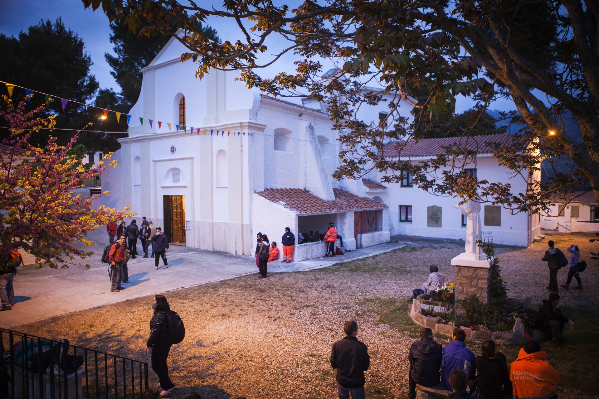
In the background, stands the Montalbo massif, bare and imperious, with a rugged hill right behind it. An austere and evocative setting accommodates a symbolic place of spirituality, where worshippers from all over Sardinia go on pilgrimages on the occasion of a double festival with legendary roots. It is the sanctuary of San Francesco, just over three kilometres from Lula: twice a year, on 1 May and 4 October, an act of devotion takes place here and it is one of the most typical and heartfelt of the Island, as described by Grazia Deledda in her novel ‘Elias Portolu’.
The origin of the celebration goes back in time to a news story, namely the unjust murder charge brought against a bandit from the village of Lula, who went into hiding to escape conviction and was forced to hide in a cave in the surrounding hills. Once his innocence had finally been demonstrated, the bandit built a small church as a token of thanks. The current building, however, is the reconstruction, dated 1795, of a pre-existing building, probably dating back to the 16th century. Inside the hall, there is a seventeenth-century wooden statue of St. Francis, a work by the Neapolitan school.
From the moment of its construction, the sanctuary was a place of worship and a destination for pilgrimages, not only for the inhabitants of Lula. So, to welcome pilgrims and participants in the novenas, arriving from all over the Nuoro area and from the rest of the island, the cumbessias were built, largely in modern times, and are distinctive stone houses built around the sanctuary, used as accommodation and to provide solace for the worshippers.
The atmosphere of mystery linked to the legendary bandit, who was forced to move only in the darkness, echoes in the procession repeated twice a year. The walk starts in the deep of the night from the church of Solitudine (Solitude) in Nuoro, covering over thirty kilometres and arriving at the sanctuary the next morning. The pilgrimage on 1 May coincides with the beginning of the novena, which ends on 10 May. The protagonists of both celebrations, in May and at the beginning of October, are the culinary traditions of Lula: you will be able to enjoy the typical dishes offered to the worshippers. Starting with su filindeu, a very unusual homemade pasta cooked in mutton broth and seasoned with cheese. Then there is su zurrette, made all over Barbagia, a salted black pudding made from mutton or lamb. Of the centuries-old rituals performed for the saint, one that stands out is sa bertula (the saddlebag), a vow in which an exchange is requested: a sick child lies in one pocket of the saddlebag and offerings from a house-to-house collection are placed in the other. Then there is sa pesada: the equivalent weight of the sick child is offered on a scale - using lamb or veal meat - as a ransom.
Once the celebration is over, it is time to leave the sanctuary: the simulacrum of St. Francis goes back to Nuoro, accompanied by the worshippers on foot or on horseback. At s’Arbore, in the Marreri countryside, a meeting with the pilgrims coming from the capital takes place and is an opportunity for a reception in the open air. The handover of the simulacrum follows in the evening, for the last stretch as far as the capital, where the procession moves three times around the church of the Rosario (Rosary) and then stops at the house of the new prior, who will guard the banner until the following May.
Ancient city of Bithia
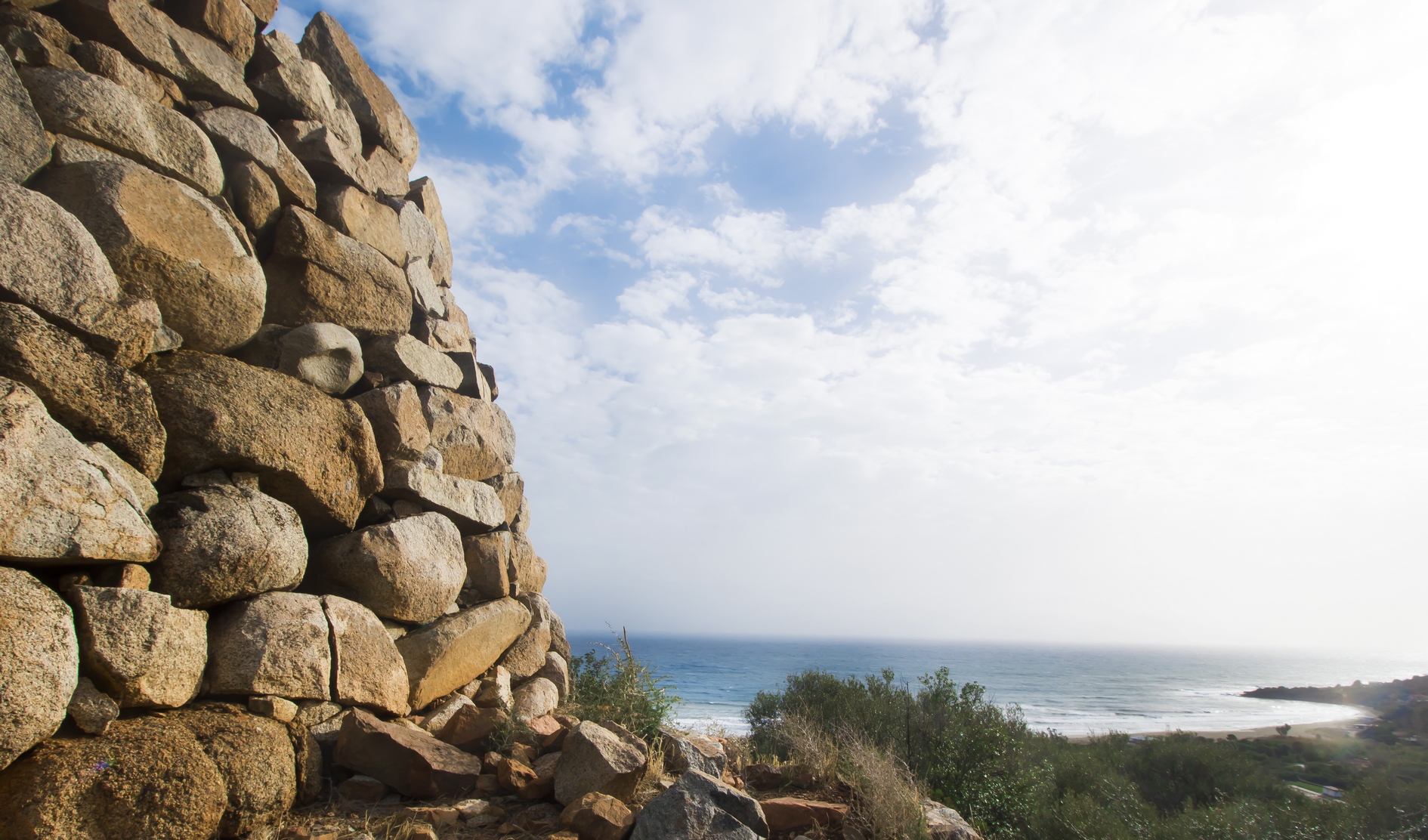
At the foot of the promontory where the tower of Chia stands, built by the Spanish in the17th century to defend the coast from pirate incursions, there are ancient historical Sardinian ruins that slowly emerge from the sea. It was initially a coastal storm, in the nineteen-twenties, that revealed traces of a necropolis and, in the years that followed, several excavation campaigns made it possible to uncover the ruins of an ancient city, an archaeological legacy of inestimable value. A treasure forgotten for centuries, surrounded by a series of heavenly beaches, the ‘seven pearls’ of Chia, a renowned tourist resort that brings lustre to the Municipality of Domus de Maria.
A Neo-Punic inscription carved into one of the ruins recovered from the sea, identified as a sacred building, also provided history with the name of the mysterious site: Bithia. Today, we know that it was inhabited for over a thousand years, from the 8th-7th century BC to the 6th century AD, until, during the last phases of the Roman Empire, the ’unobstructed ’ pirate incursions in the western Mediterranean forced its inhabitants to take refuge inland. Until then, Bithia, which was built on a pre-existing Nuragic settlement, must have been a thriving harbour town, first Phoenician, then Punic and lastly Roman.
The architectural evidence of what must once have been a lively coastal town is partially hidden by the Mediterranean vegetation, which covers the slopes of the promontory where the town probably stood. Unlike the other Phoenician-Punic towns, like Nora and Tharros, Bithia continues to hide a great many secrets and, therefore, reconstructing its urban fabric is complicated. It may have included several agglomerations arranged around the only necropolis at the foot of the acropolis that, according to some, stood on top of the promontory of the tower. However, you will be able to observe the outlines of the walls and of the individual houses more clearly. The sacred, burial area dating back to the Phoenician period is also mysterious: according to some, it was a tophet, that is an open-air sanctuary, containing the incinerated remains of babies and children, placed inside ceramic urns. Much of the rest of the ancient city has been lost and some of its treasures are now abroad, while others have been relocated in Sardinian museums, such as the statue of the god Bes, on display at the national archaeological museum of Cagliari: it is more than a metre high, made of sandstone and perhaps represents a salvific divinity, to which the iconography of the Egyptian divinity was associated. Its original home, where the inscription showing the name of the town was also found, is now probably buried inside a private property, but it was studied during the excavation campaigns carried out in the 20th century and was identified as the temple of Bes.
If you want to delve deep into the history of Bithia, you can reach the site via the path, indicated in the Antonine Itinerary, which formerly connected the urban centre to the nearby town of Nora, today the archaeological park of Pula. The starting point is the little beach in the locality of Pinus Village. As you move along some stretches of the itinerary, you will notice the road with stone paving made of polygonal blocks. The view is spectacular: you will be walking close to the forest of is Cannoneris, along the coast, with numerous views of enchanting coves and elevations. Some of these, such as the mountain of sa Guardia, can be reached via detours on the path. You will then move alongside the islet of su Cardulinu, connected to the coast by a narrow strip of sand, on which what may have been a Phoenician tophet and another Punic temple were found. Lastly, you will reach the foot of the Aragonese tower.
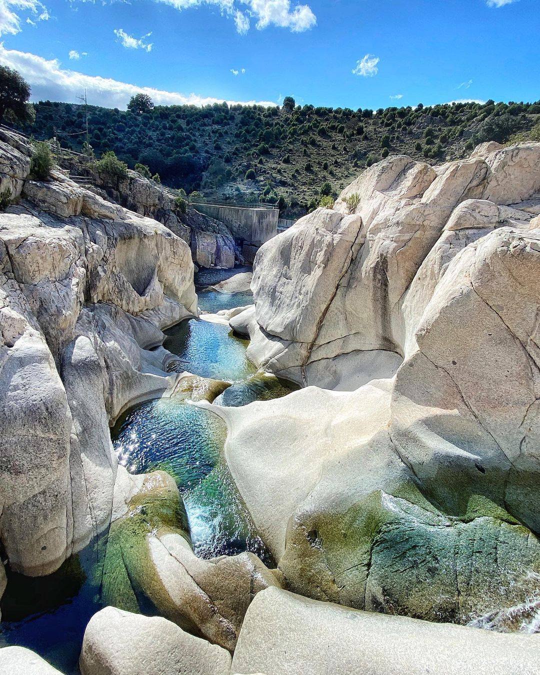
Bau Mela natural pools
When thinking about Ogliastra, its traditions, longevity and flavours of the typical local products and cuisine come to mind but, perhaps most of all, the breathtaking natural scenery. On the border of Barbagia, in the Villagrande Strisaili area, an oak forest contains one of its gems: the natural pools of Bau Mela. You’ll find yourself admiring an oasis where the current of the stream of the same name has carved and shaped the granite and through two small waterfalls in rapid succession it generates a captivating series of cascades and ponds. The first waterfall is the most impressive and it creates the largest pool, while the second is divided into other equally accessible little pools, where you can immerse yourself in the crystal clear water surrounded by mighty granite walls. The landscape on your way to this natural masterpiece is no less magical: lush Mediterranean scrub, centuries-old junipers and expanses of asphodels will accompany you on a journey through wild and uncontaminated landscapes.
The importance of this water resource is also based on the presence of a dam and a hydroelectric power plant, which you can see along the way, and are part of a system for managing the waters of the area, taking the name of the upper Flumendosa plant and also includes the nearby dams of Bau Mandara and Bau Muggeris.
In the surrounding area, you will also find other places to explore: a fascinating route – equipped with tables for taking a break and picnics – leads to the majestic Sothai waterfall, which flows into the Bau Vigo canyon. In the territory of the nearby hamlet of Villanova Strisaili, about 700 metres above sea level, is the Pirincanes gorge, created by the Rio ‘e Forru, where the water has eroded the pink granite, forming a series of natural pools, called ‘cauldrons of the giants’.
Such natural beauty did not leave the forefathers of the Ogliastra area indifferent and it is no coincidence that this area is rich in archaeological evidence: the Park of Santa Barbara contains seven Tombs of Giants and a megalith, 17 nuraghi and ten Nuragic villages. Villanova Strisaili’s surroundings include other sites: those of s'Arcu e is Forros, where it is possible to admire a megaron temple and two well temples, various domus de Janas, the complex of Troculu – with two nuraghi, a village and a Tomb of Giants – and the archaeological area of sa Carcaredda.
Villagrande Strisaili is the ultimate town of centenarians, guarding ancient traditions that have been handed down unchanged for centuries and can be found in the celebrations, such as the feast of San Sebastiano, and in the local crafts and traditional cuisine.

Capo Figari and Figarolo island
It is a natural open-air museum that embellishes the coast of Golfo Aranci, in Gallura. The promontory of Capo Figari, along with the islet of Figarolo in front of it, have been declared a Site of Community Importance and are treasure troves of biodiversity. You can get to the promontory via the beach of Cala Moresca, a ‘gem’ set in a little bay and cooled by a pine forest. The summit of the promontory is just over three kilometres from the cove and, at the top, at a height of 350 metres, are the remains of the Naval Semaphore, inaugurated in 1890, purchased by the Ministry of Defence 15 years later and made famous in 1932 by Guglielmo Marconi, who built a shortwave radio link there, connecting it to the transmitter in Rocca di Papa, near Rome. From up here, you can enjoy a breathtaking view: to the south, you can see the entire gulf of Olbia, with Capo Ceraso and the island of Tavolara, while to the north, you can see the islands of Soffi and Mortorio with the Costa Smeralda in the background.
Various trekking trails are marked out on the promontory, thanks to which you can observe other pieces of historical evidence that underline the importance and the use of the site over the years. Behind Cala Moresca, there is a furnace for the production of lime, which was abandoned after just a few years of use. Moving on along the Filasca trail, you will come to the Luigi Serra coastal battery, built during the First World War on the peak that gives the trail its name. You will notice the remains of turrets and circular bases on which the cannons were anchored. A detour will take you to a small cemetery, called ‘of the English’, in honour of the burial of an English sailor, accompanied by a Celtic cross, though in reality, it is mainly the burial place of Italian sailors who disappeared during various shipwrecks. Going beyond, you will reach the picturesque Cala Greca, with its deep waters that give the sea a strong blue colour. Nearby, you will notice the unusual rock of Mamma Chiatta, a name given to it by the fishermen of Golfo Aranci because of the outline that, according to them, resembles an overweight elderly lady. The northern side of the promontory will treat you to other captivating views of places that can be reached by sea, like Cala del Sonno and Cala Fenice.
In front of Cala Moresca, Figarolo appears. Its name comes from the presence of flourishing fig trees. The island is a limestone plateau with an unusual pyramid-like shape. A variety of wildlife resides there: moufflons, cormorants and buzzards. The raven also passes through and sometimes the peregrine falcon nests there. The vegetation includes holm oaks, lentisk trees and thousand-year-old olive trees. The surrounding seabed is a paradise for diving enthusiasts: shallows, underwater caves, black corals and also groupers, lobsters, corbs, sea urchins, sponges and sea fans. Off the island, lies the small wreck of a merchant ship that sank in the mid-20th century.

Cabu Nieddu
A spectacle that is unique on the island, very rare in Italy and unusual in the rest of the world: the waters of the Cabu Nieddu waterfall fall directly into the Sardinian Sea, a forty-metre drop, from a vast natural amphitheatre dug out of a high stretch of coast between the famous bay of s’Archittu and the Marina of Tresnuraghes. We are in the territory of Cuglieri, in the historical region of Montiferru, which gets its name from the massif of volcanic origin that dominates a landscape of plateaus, woods and rivers. One of these watercourses, rio Salighes, is the protagonist of the magnificent scenario: it crosses the solid layer of basalt rock that stretches as far as the Campeda plateau, until it touches the coast and flows into the sea.
In spring, the more abundant the winter rain, the more spectacular and unforgettable is the ‘plunge’ of s’Istrampu de Capu Nieddu, as it is known locally. The origin of the phenomenon lies in the volume of the river, which flows over the surface of the land up to the coast, because over thousands of years, it has never been large enough to gouge the hard basalt rock and create itself an underground ‘bed’ on which to proceed.
You can admire the whole waterfall in a boat, from a privileged position, setting off on a tour from Santa Caterina di Pittinurri, Bosa or Oristano. The view is spectacular, with the blue sea and the green slopes of the Montiferru massif: a landscape that brings to mind the famous Irish Cliffs of Moher. The elevations are covered in holm oaks, chestnut trees, strawberry trees, broom plants, wild roses and hawthorns, as well as the fragrances of thyme and helichrysum. Looking north, you can see the coast of capo Marargiu, where griffons dare, and in the distance the promontory of Capo Caccia; to the south, you can see Capo Mannu and the islet of Mal di Ventre. After seeing the waterfall, you can continue the tour towards the Spanish tower of Capo Nieddu and even further north, towards the mouth of the Rio Mannu river, where you can admire the view of Punta Foghe, also guarded by an ancient watchtower.
The surrounding area is dotted with evidence of the ancient volcanic activity of the massif, which shaped the current harsh and diverse landscape: in addition to Cabu Nieddu, in the valley of riu s’Abba lughida there is the waterfall of s’Istrampu ‘e Massabari, while a little further south, on the border between the territories of Bonarcado and Santu Lussurgiu, the valley of riu sos Molinos opens up and generates the waterfall of the same name, another unmissable masterpiece of nature.
Cane Malu
Going for a swim in a pool on the moon? You can imagine the scenery and experience the sensations in the cove of Cane Malu, three kilometres from the medieval village of Bosa. The natural pool is located on the tip of Cabu d’Aspu, a few steps from Bosa Marina, where the northern stretch of the Bosa coast begins, in the Capo Marargiu direction. You will reach it after walking for about ten minutes along a path that, setting off from the river port at the mouth of the Temo river, runs alongside the sea, over cliffs of white trachyte, the typical local stone. It is precisely this particular type of rock that creates the lunar scenery, a surreal, white landscape, which is counterbalanced by the intense turquoise colour of the sea. Countless storm surges, driven by the force of the northwesterly wind, have gorged and shaped the trachyte over thousands of years, creating the shape of a large ‘basin’, bordered by a band of rock. The white strip of trachyte resembles a dog's tail, especially when the sea is rough, hence the name: ‘bad dog’. Not surprisingly, it is a unique jewel of nature that requires prudence and, in fact, it’s best to choose a day with no wind and with a calm sea, to fully enjoy the charm of the pool. Then, if you wait for the sunset, the play of light between the light colour of the cliff and the reflections of the sea will treat you to unforgettable sensations.
Cane Malu is cosy and comfortable for those who want to lie down and relax in the sun. The surrounding beaches also offer relaxation: to the south of Bosa Marina is the beach of Turas, famous for its spectacular sunsets, while four kilometres north of the village is the beach of s’Abba druche, with its white, grainy sand mixed with pebbles and its shallow waters. Moving even further north, you will be surprised by the wild scenery of Cumpoltittu: the coast is protected on both sides by promontories covered with Mediterranean scrub stretching down to the sea with its blue and turquoise water. Not far away, the small cove of sa Codulera has a pebbly seabed and a transparent sea suitable for snorkelling, while Torre Argentina will strike you with its alternating inlets, coves and reefs that plunge into the cobalt blue sea.
Not only splendid beaches: the 45 kilometres that separate Bosa from Alghero are a setting worthy of a Hollywood film. Provincial road SP 49 - which becomes provincial road SP 105 halfway along - offers irresistible views, pink trachyte rock walls, expanses of yellow broom, shimmering reflections of the sea, ranging from emerald green to turquoise, and sheepfolds scattered here and there that have become guardians of the coast, a role that once belonged to the Spanish towers.