
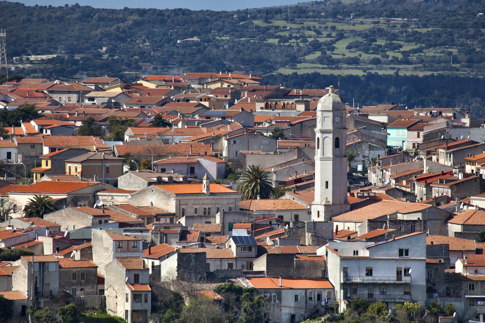
Thiesi
The adjective tiesu means ‘laid out’. Hence, it is not surprising that this inhabited area lies on a plateau on the slopes of the plateau Su Montiju. Thiesi is a town with 3,000 inhabitants in the Meilogu region, 40 kilometres from Sassari, which some sources claim was founded by a Jewish community who had been exiled by the Romans. Today, large dairy industries operate here with cheese production being the main activity. The flavours of the local cuisine are captivating, with sas impanadas, timbales filled with aromatic pork meat, su succu, durum wheat fregola pasta cooked in broth, and su ghisadu, lamb cooked in tomato sauce. The urban layout has advanced in two areas: around the 17th-century church of Sant’Antonio and around the parish church of Santa Vittoria, a beautiful Gothic-Aragonese construction built between 1400 and 1590, highly decorated within and featuring a Renaissance portal.
Originally, the shape of the village was triangular with three other churches at its tip: San Sebastiano, San Giovanni, immersed in the lush Badde Serena valley (and reachable via a stone staircase) and the Santuario della Madonna di Seunis, on the outskirts, built in 1700s (then later remodelled) on a rocky spike overlooking the valley of the Rio Molinu. Today, it is a destination for Marian pilgrimages. At the beginning of September, the most heartfelt celebrations are held, with a procession accompanied by folk groups and knights from the Meilogu region. The feast of Santu Juanne is at the end of June. Within the village, there is the stunning complex of the ancient prison-tower, built to defend against the Aragonese (15th-16th century), that was later transformed into a place for detention during the Savoy period. There is also the mural ‘The Year of the Assault’ (on the Angioy uprising of 1800) by the local painter Aligi Sassu.
Ten kilometres from the town, there is the Mandra Antine necropolis with four Domus de Janas carved into a trachyte ridge. One highlight is the “painted” Tomb III with refined and colourful frescoes within. This is one of the most surprising legacies of the Neolithic period (3rd millennium BC) in Sardinia. Also outside the village is the Protonuraghe Fronte ‘e Mola. It is one of about 350 Nuragic structures in the Meilogu region, a territory that will conquer hearts also due to its naturalistic features, such as the extinct volcanic cones that stand isolated - the Colle Santu Bainzu di Thiesi is one of the five volcanic craters in Meilogu and a fascinating protected natural monument, which creates an unusual and unique landscape. Another spectacle of nature is the Grotta di Monte Majore cave, which opens via a wide entrance on the eastern side of the mountain. Upon a short and easy descent, a hall full of concretions is accessed, expanded across 300 metres. Branching out in another direction is a splendid white outpouring and a tunnel that flows into a second domed room. The cave houses a colony of around 5,000 bats.
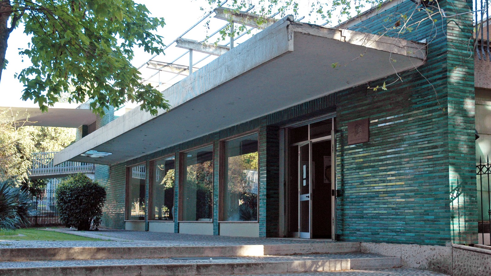
Tavolara pavilion for handicrafts and design
Two great Sardinian twentieth century minds, linked by a building-masterpiece, a place of art and identity, knowledge and know-how: the forms inspired by the Neoliberty style of the architect from Cagliari, Ubaldo Badas, and the decorations of the artist from Sassari, Eugenio Tavolara, created one of the best Sardinian expressions of modern architecture, located in the public gardens of Sassari. Inaugurated in 1956 and dedicated to Tavolara, the pavilion has been the headquarters of the Sardinian Institute and Organization of Artisan Work (Istituto Sardo Organizzazione Lavoro Artigiano - ISOLA), which spread the image of a creative and authentic land. It hosted the first exhibitions of artefacts curated by the artist, leading to worldwide fame. Today, now restructured, it will accommodate the museum of handicrafts and design, with the greatest 'public' collection of works by Tavolara and that of ISOLA acquired over six decades: ceramics, baskets, jewellery, fabrics and other products.
The building extends over two floors, with a total of three thousand square metres, built with a combination of materials used creatively: colour combinations, coloured tiles, decorated railings. Its current appearance, following redevelopment concluded in 2013, will enchant you with the idea, conceived by Badas, of continuity between the inside and the outside. Ponder over the external volumes, which are lively and articulate, and the openings that 'follow each other' to enclose the large exhibition spaces. A staircase with reliefs of the Cavalcata Sarda (Sardinian horse-riding folklore event) by Tavolara leads to the single space on the upper floor. The rest of the interiors are also adorned by the skilled hand of the designer.
The central nucleus is the courtyard, where the bright glass windows of the exhibition halls look out, supported by light pillars. A long external wall accompanies a 'path of water' in the pool: in the centre, there is a fountain embellished with coloured ceramic reliefs, the work of Giuseppe Silecchia. The external staircase was originally suspended over the water, giving the effect of 'lightness'. The last touches were made to the exhibition halls, laboratories, terrace with a dining/refreshments area, entrance ramp tunnel, hall of the Workshops and a false ceiling made of red wood, dotted with lights to resemble a starry sky.
In Sassari, you can pass from Sardinian art and handicrafts to a concentration of history and archaeology, by visiting the Sanna Museum. In the old town centre, don't miss a visit to Piazza d'Italia and its most important religious buildings: the cathedral of San Nicola di Bari and the churches of Santa Maria di Betlem and Sant'Apollinare. In the outskirts, you will find another symbol of Sassari, the Fontana of Rosello fountain.

Sant'Antonio di Gallura
Rising to 350 metres high, Sant’Antonio di Gallura is surrounded by granite mountains and deep valleys lush with oaks, holm oaks and Mediterranean scrub, backdropping the Lago del Liscia. The village is populated by 1,500 inhabitants, including those of the hamlet Priatu and various villages. Until 1979, when it became an independent municipality, it was called Sant’Antonio di Calangianus, after the municipality on which it depended. An obligatory waypoint from the inland heading towards Costa Smeralda and the Parco dell’Arcipelago della Maddalena, it is the ‘heir’ of Villa de Castro, whose existence is documented by Liber Fondachi (1317) and Compartiment de Sardenja (1358) and of findings of burials, jewels and coins, including a Genoese coin from 7th-8th century. The early medieval village was located at the foot of the Lu Naracu overlook, today the highest point of the town from which you will admire views ranging from the Limbara massif to the Arzachena and Palau sea. From this height, it is possible to see the hills dominated by the stazzi (rural settlements), fundamental elements of the Gallura agricultural-pastoral culture. It is surrounded by Liscia, the largest artificial reservoir in the island’s north, formed by the dam of the same name. You can coast along the side of Sant’Antonio aboard the Trenino Verde (Green Train) and cross its waters aboard a paddle boat. On the side of Luras stand the 1,000-year-old olive trees of Carana.
The name Lu Nuracu, together with the toponym Lu Nurachéddu (in Campu d’Idda), are the ‘clues’ to the territory’s use in the Nuragic age. Near the viewpoint stands the Chiesa di Sant’Andrea, dating back to the mid-18th century and elected as a parish in 1907 (for only five years). Around the small sanctuary, the new inhabited nucleus developed. With the increase in population, the construction of a major church was necessary. Hence, the new parish church of Sant’Antonio Abate was built in 1912, having a basilica layout with three naves divided by arches, a high altar and frescoed apse. The patron is celebrated in mid-January with the Fuochi di Sant’Antonio Abate event. Not to be missed is Palazzo Mannu, in the noble architecture of the Gallurese, built entirely of granite. Doors and windows are outlined by architraves and jambs, whilst the upper floors are adorned with wrought iron balconies. The interior preserves furnishings and structures from the early 20th century. Nearby are charming country churches, and venues for hosting events, where you will discover the most authentic Gallura delights and savour delicacies such as Zuppa Gallurese and Mazza Frissa. There is the Madonna di La Crucitta and the sanctuary of San Giacomo, celebrated in May, San Leonardo and San Giuseppe, celebrated in June, and the rocky church of San Costantino, perhaps of early medieval origin, next to which there is Lu Pulteddu, a sort of ‘window’ that, according to tradition, upon being passed by three times, cures abdominal pain.
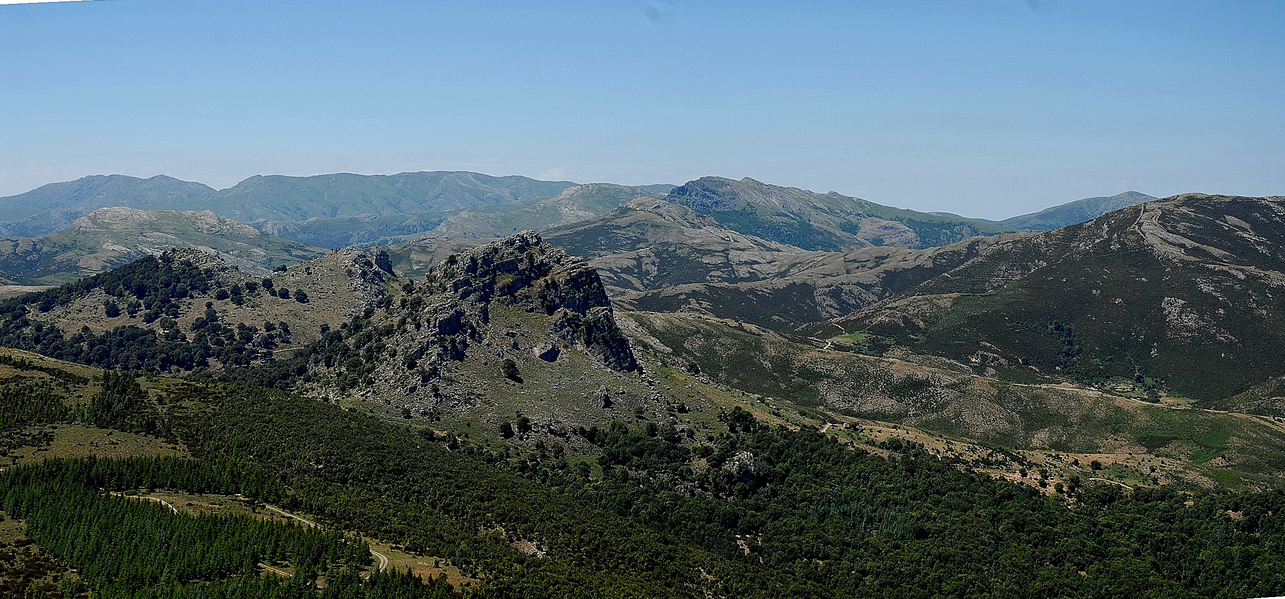
Supramonte di Baunei
The Supramonte is a mountainous complex characterised by carbonatic highlands and dolines. With an area of around 35,000 hectares, it also takes in the long stretch of coastline of the Golfo di Orosei and it falls within the territorial areas of the municipalities of Oliena, Orgosolo, Urzulei, Dorgali and Baunei. Enormous rocky bastions characterise the landscape, alternating with deep canyons and rocky peaks that tower into the sky. The Supramonte, for ease, is divided according to the territories of the municipal areas in which it falls. The Supramonte of Baunei is situated in the eastern extremity of the highground, in the highest part of the Ogliastra, and is home to the famous calcareous pinnacle called Agugliastra or Perda Longa, the Punta Ginnircu and the Pranu Supramonte. Also very characteristic in the territory of Baunei is the cave of Su Sterru, which is 275 m deep. A jump into the deepest darkness at the centre of the heart of the Sardinian land. The abyss is among the deepest single span whirlpools in Europe and legend has it that it originated from an awful struggle between a terrible snake, master of the highland of Baunei and San Pietro who wanted to free the inhabited area from the terrible animal. The final battle saw the victory of San Pietro that grabbed the reptile by the tail, beating it to earth with so much force as to form the deep abyss. As a sign of gratitude, the inhabitants of Baunei built a rural church in the vicinity of Su Sterru that is still today devoted to San Pietro.
Loiri Porto San Paolo
The two main residential areas, little villages and stazzi, merge together into a single dimension. The little village of Loiri and the marine village of Porto San Paolo merged to create a single Municipality in 1979, along with a myriad of districts surrounded by Mediterranean greenery. A majestic centuries-old olive tree welcomes you at the entrance to Loiri: the municipal 'capital' has three thousand 500 inhabitants and stands amidst low hills, about 15 kilometres from the sea. The coastal village, which has accommodation facilities, services and a modern tourist port, is frequented by 15 thousand people in the summer. According to legend, the apostle Paul stopped here in Antiquity, before withdrawing to a hermitage deep in the Gallura area.
Loiri Porto San Paolo, which is exactly halfway between Olbia and San Teodoro, shares 15 thousand hectares of sea and 40 coastal kilometres of the marine area of Capo Coda Cavallo with them. Ferry services leave here every day allowing you to visit the wonders of the impressive island of Tavolara and the smaller islands of Molara, Molarotto, Piana and the Isola dei Cavalli. During Una Notte in Italia (A Night in Italy), the famous film festival on the island of Tavolara, you will be in the company of actors and film directors starring in the event along the stretch from Porto San Paolo to the island. Another event not to be missed is the nautical fair.
There are eight churches in the villages and hamlets: worthy of note is the church of Santa Giusta, in the district of the same name, the first medieval centre of the future Municipality and, in Loiri, the parish church of San Nicola di Bari, featuring a façade made of exposed granite stone and an architrave portal, with a bas-relief depicting a scene from the life of the saint. There are patron saints celebrations associated with the religious buildings, in which the Choir of Loiri performs: San Nicola (St Nicholas) is celebrated at the end of August and Sant'Antonio da Padova (St Anthony of Padua), in mid-June.
The first sporadic traces of humans in the territory date back to the Neolithic age. It was later frequented much more intensely: on a hill near Loiri, you will see ruins from the Nuragic period. During the Punic-Roman era, this area continued to be frequented uninterruptedly, as in the district of Enas.

Nostra Signora di Talia
Its charm lies in its archaic appearance and the simplicity of its forms, as well as the privilege of becoming the home of a work, every Christmas, unique in Sardinian and with very few other examples in Italy. The Romanesque church of Nostra Signora di Talia stands in the eastern part of Olmedo, overlooking the square of the same name. The name probably comes from the statue of the Madonna d’Italia, found during the 18th century among the ruins of Talia, a village that no longer exists. The church – also known as Nostra Signora di Ulumetu – has features that suggest it was built by Tuscan-Lombard workers, probably in the first decades of the 12th century. The materials used were limestone, reddish tuff and basaltic trachyte.
Thanks to a series of recent restorations, which removed several layers of plaster applied over the centuries, you can now admire the original façade: in the lower part, slightly-carved cornerstones were used, while near the top, squared ashlars were positioned in a more regular way. An architraved portal opens up in the centre, with a relieving rounded arch. The lunette has a fresco depicting the Madonna with Child and the side naves and the sloping roofs are delimited by a row of small arches, which are interrupted on the sides of the façade next to the corner pilasters. In line with the portal, there is also a small cross-shaped opening. Other circular windows open up on the sides and in the apse. The internal layout has three naves, divided by small arches supported by columns decorated with capitals and slab abacuses. The central nave is covered by a wooden roof, while the lateral naves have barrel vaults. The presbytery is raised with respect to the main body of the church and is preceded by two square-shaped pillars.
Every year, from Christmas Day to Epiphany, the church fills with visitors thanks to the spectacular nativity scene inside it. The unusual feature of the nativity scene is that it is made entirely of bread, which is used to shape the landscape and all the sacred characters. You will also see scenes of traditional life, such as cheese-making, fishing and household chores, with houses, farms and nuraghi.
Leaving the town, you will visit the archaeological heritage of Olmeda: the most famous legacy is the fortress of Monte Baranta. There is a pre-Nuragic settlement around a mighty megalithic wall, with an enclosure-tower and huts, while outside there is a sacred area, in which a circle formed by orthostatic slabs and menhirs stands out. Then there are the nuraghi Mannu and Talia, a name that often recurs, dating back to the Bronze Age.
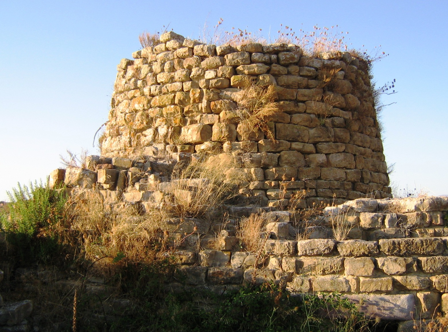
Nuraghe Piscu
The name is said to derive from su piscu, the bishop of the diocese of Barbaria, who received numerous donations from the judges of Cagliari, including the land where the archaeological park stands. The Piscu Nuraghe stands imposingly on a hill, along the SS 128 road to Senorbì and Mandas, just a short distance from Suelli, which was the bishop's seat in the Middle Ages and has always been a centre of veneration for Saint George the bishop.
Mentioned in various medieval documents and known locally as sa domu de s orcu, the Piscu is the most monumental and best preserved of the 200 nuraghi surveyed in Trexenta, archaeologically 'investigated' and restored in the 1980s. The majestic complex architecture arose between the Middle and Recent Bronze Age (15th-11th centuries BC), built of marl blocks, hewn and arranged in regular rows, and consisting of a main tower, the oldest of the structure, and four corner towers, joined by thick walls, which were built at a later stage. Inside the bastion, almost a square with sides of about thirty metres in length, is a courtyard. Around it, a low bulwark of large boulders 'embraces' five projecting towers and encloses a village of numerous circular and quadrangular huts.
The main tower, nine metres high and eleven metres in diameter, is accessed through an architraved entrance with a relieving space above. The corridor has two opposing niches and leads into the large tholos (a false dome) chamber, built with hewn blocks of limestone. The technique is 'overhanging': the rings decrease in diameter as you ascend. Originally it must have consisted of two floors accessible by a staircase or through external terraces. The corridor then leads into the courtyard, with entrances to the four secondary towers of different sizes. Two of them are contiguous, so the unusual plan appears to be that of a trilobate rather than a quadrilobate structure. The four towers have niches and slits, the largest being similar in size to the keep, with a circular chamber and a T-shaped room. On the inside of the wall, a well has been unearthed, which served as a cistern for collecting rainwater. Various types of vessels were found at the bottom, some small with handles and diagonally cut upper openings (possibly glasses). The first excavations date back to 1860: in the keep, a large jar embedded in the ground and covered with a plaque, oyster shells, boar tusks and animal bones were found; in a chamber and in the hallway, a bronze bowl, potsherds, pieces of millstones, a piece of marble, perhaps used for tanning hides and charred grain.
The Piscu is the most iconic building in an area with many pre-historic finds, guarding the surrounding fertile valleys. From the small hill on which it stands, you can see other nuraghi, some 15 of them, including Planu Senis, as well as pre-nuragic sites, such as the necropolis of Pranu Siara and Santu Perdu.
Supramonte
Its extension, of over 35 thousand hectares, gradually becomes invisible to the naked eye and is large enough to contain the territories of five villages, Baunei, Dorgali, Oliena, Orgosolo and Urzulei, and part of the Gulf of Orosei. Supramonte is a mountain range featuring plateaus and sinkholes. The landscape has distinctive features identical to each other: huge bastions, deep canyons and rocky peaks towering up towards the sky. However, each municipality has its ‘own’ Supramonte, with original and unique natural monuments.
The Nuragic village of Tiscali enriches the territory of Dorgali and Oliena. The Grotta del Bue Marino is the undisputed symbol of Dorgali; the gorge of Su Gorroppu identifies Baunei and also Dorgali. In the Supramonte di Oliena area, above the valley of Lanaittu, the cave of Corbeddu is well worth a visit. Its name comes from the bandit who took shelter here in the 20th century and it is well-known for being the place in which the remains of a deer, already extinct in the Sardinian Pleistocene era, was discovered, from which the humans are presumed to have been present on the massif 18,500 years ago. Then there is Urzulei, characterized by lush vegetation and the cave of Palu. The sinkhole of Su Suercone, a limestone chasm 500 metres wide and 200 metres deep, and the unspoilt forest of Sas Baddes, the only extensive primary Holm Oak forest in Europe, are the distinctive features of the Supramonte area of Orgosolo.
Also in Oliena, you will remain speechless at the sight of Mount Corrasi, the highest peak in the mountain range (1463 metres), featuring a barren, rocky environment with chasms, aiguilles and unusually-shaped pinnacles, covered by 650 botanical species, most of which are exclusive to the limestones of central Sardinia and some of which exist only in the Corrasi area. It is also home to the Nurra de sas Palumbas, a cave famous for its wildlife.
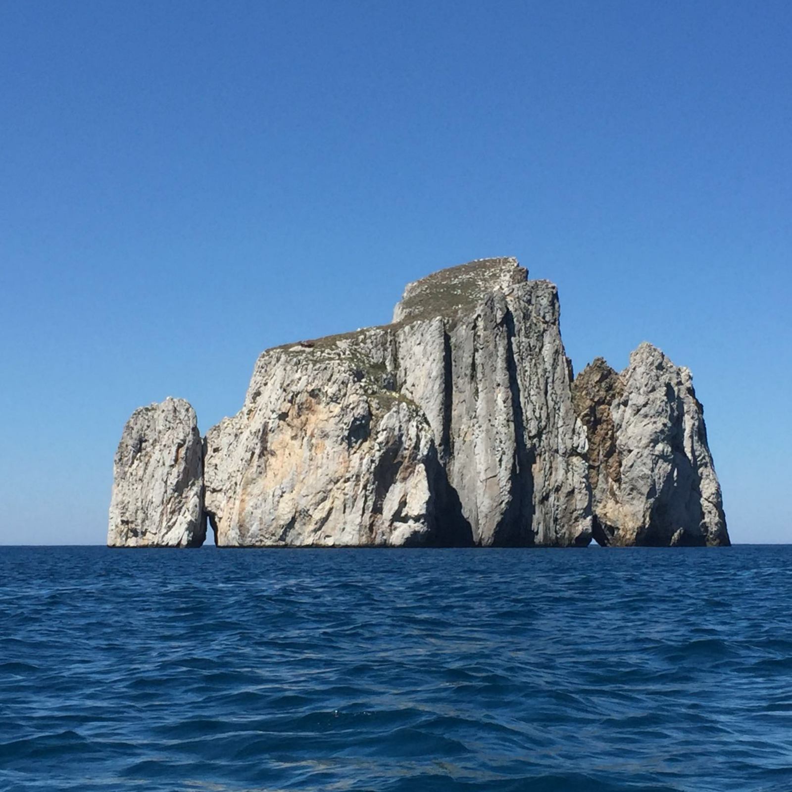
Pan di Zucchero and sea stacks of Masua
Admiring the impressive rock at sunset, as it rises out of the sea just a few metres from the coast, increases its splendour: the sunlight bounces off the limestone silhouette in every shade of yellow and orange. Pan di Zucchero (meaning Sugarloaf) is one of the most impressive and spectacular natural monuments on the Island and the symbol of the coast of Iglesias. The name comes from its resemblance to the famous Pão de Açúcar (Sugarloaf Mountain) in the bay of Rio de Janeiro and in the 18th century, this name had already replaced the original Sardinian name Concali su Terràinu. You can get to it in a dinghy or by boat from the magnificent cove of Masua, a coastal district in the Iglesias area, just two and a half kilometres away.
Once having succeeded in reaching its rocky walls, which is not so simple, climbing enthusiasts, with equipment and supported by expert guides, can climb up its 133 metres: it is the highest sea stack in the Mediterranean. From the top, you will be able to see its three ‘younger brothers’ next to it, two of which are known as s'Agusteri and il Morto, the southernmost one. The four sea stacks of Masua are structurally homogeneous, connected and an integral part of the monument: their cerulean-white colour stands out against the violet-coloured coast in front of them. They are composed of Cambrian limestone, which is chemically almost pure, and they were formed by the erosion of the sea, which generated their detachment from the mainland and specifically from the cliff of Punta is Cicalas: the 300-metre stretch of sea separating them is often inaccessible.
Pan di Zucchero has a massive, rounded shape. Karst phenomena have pierced its surface (less than four hectares) with flat steps, leading to the creation of two tunnel-like caves. They open up at sea level, are 25 and 20 metres long respectively, and are both habitats for seabirds. It is possible to pass through one of them in a small boat. Opposite the little island, the outlet of the Porto Flavia mining tunnel looks out to sea, magically suspended halfway up the sheer rock face. It is the most visible extremity of a futuristic complex of underground tunnels that end at a construction carved into the cliff at the beginning of the 20th century. From here, the minerals were loaded directly onto merchant vessels. At the foot of mine, there is the cave of Grotto del Soffione, so called because of the effect of the waves that enter the cavity and ‘bounce’, making big splashes. Alongside the ruins, there is the little beach of Porto Flavia mine: from the small lido, a destination for scuba diving enthusiasts, you will be dazzled by the contrast of colour between the greyish-white of the giant marine limestone rock, the azure and blue of the sea and the green of the surrounding pine forest.
The entire coast of Iglesias has a wild appeal and a great variety of landscapes. Not to be missed, are Porto Paglia and Nebida, another small ‘mining’ district. Two kilometres to the north of is Cicalas is the Grand Canal of Nebida: it is a long, narrow valley, crossed by a torrent that flows to the sea in a splendid ‘fjord-like’ inlet, characterized by a small beach and a series of caves: at the foot of the cliff there is the Grotta di Canal Grande, a 150-metre long tunnel carved by the sea that crosses the promontory from one side to the other, just above the surface of the water; under the north wall, the Grotta delle Spigole (cave of the sea bass) opens up. Further north, there are the inlets of Porto Sciusciau and the beautiful Cala Domestica, in the territory of Buggerru. You can also visit the Grand Canal via land, departing from Masua: a trekking trail along the tracks of the mining works. The coastline and, more generally, the life of the Iglesias area were deeply marked by mining activities. At the end of the 19th century, a great deal mining work took place at the Masua mine, while today the complex includes dwellings located on various levels, a school, a hospital, a church and workshops. It is a ghost village and a stage of the Santa Barbara mining route as well as being part of the Geomining Park of Sardinia, recognized as a UNESCO world heritage site.
Supramonte di Dorgali
The Supramonte is a mountainous complex characterised by carbonatic highlands and dolines. With an area of around 35,000 hectares, it also takes in the long stretch of coastline of the Golfo di Orosei and it falls within in the territorial areas of the municipalities of Oliena, Orgosolo, Urzulei, Dorgali and Baunei. Enormous rocky bastions characterise the landscape, alternating with deep canyons and rocky peaks that tower into the sky. The Supramonte, for ease, is divided according to the territories of the municipal areas in which it falls. The Supramonte of Dorgali falls among the valleys of the Flumineddu and the Cedrino and also contains the basin of the Lanaittu. On the border with the valley of Lanaittu a steep calcareous mountain rises, that was home, inside an enormous doline, to the spectacular Nuragic village of Tiscali. The gorge of "Su Gorroppu" is remarkable: deep and narrow, it separates the Barbagia from the Ogliastra. It is a splitting between the calcareous mountains of Dorgali and those of Oliena and it makes a favourite shelter for rare species of birds of prey. Its extends as far as the coast up to Cala Luna with characteristic examples of calcareous rock, smoothed walls and large fissures. Numerous caves open out onto the coast, among which that of Bue Marino famed for the presence of the monk seal in times past.