
Segariu
Its name derives from s’ega ‘e riu, meaning the ‘marshy river valley’, or from segau de s’arriu, meaning ‘cut in two by the river’, because of the town’s location in a valley crossed by two tributaries of Flumini Mannu. Segariu is a town of 1200 inhabitants close to the border between the Marmilla and Trexenta historical regions with characteristics of both: the rolling hills covered pine groves and Mediterranean shrubs of Marmilla, and the rugged hills interspersed with cultivated, fertile, flat stretches of Trexenta. The town is known for traditional kaolinite and limestone shaping, with clay bricks and roof tiles being produced. In the centre of town, the Museum of Clay, a testimony to the importance of this tradition, is dedicated to salvaging this craft, which has defined the town for centuries. The exhibition is an accurate reconstruction of a local roof tile workshop. Here, visitors can observe and participate in workshops lead by clay working masters. The Perdas e Minas exhibition also focuses on this activity, atypical with respect to the surrounding Campidano farming reality, with period photographs, working tools and accurate reconstructions of production processes. Another demonstration of this tradition is the Tebajus event in July, which in addition to activities linked to the local production of fired roof tiles, includes craft shows and an exhibition of typical products.
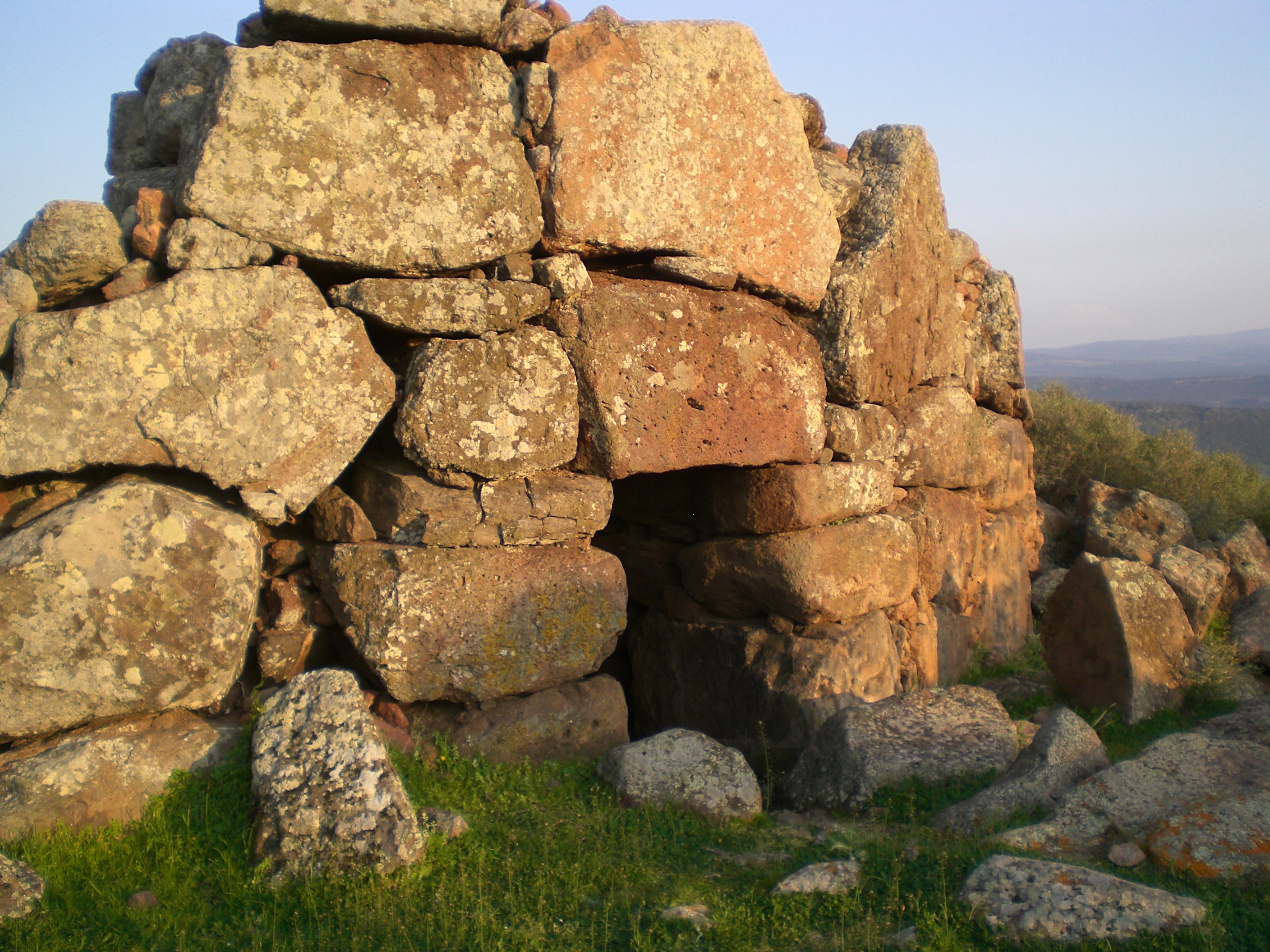
The area has been inhabited since the Bronze Age as seen from the Franghe Morus Nuraghe and the four-lobed Nuraghe of Sant’Antonio, a nearby symbol of Segariu. Built using limestone and marl blocks, it has one central tower and four external towers oriented along the four cardinal points. The area immediately to the east of the nuraghe and its interior have produced artefacts of a large and interesting Late Punic settlement. A Giant’s Tomb was likely located nearby, just as the small country church dedicated to the same saint built between the 12th and 14th centuries in Late Romanesque style over a well temple most probably coeval with the Nuragic settlement. It is one of the many Sardinian expressions of continuity between different cultures and religions. The celebration in honour of Saint Antonio is held in early September, where in addition to religious events, a tasting of typical local products and dishes is held. A 17th century Parish of San Giorgio Martire stands in the town’s centre. It has a presbytery topped with star vault typical of the Catalan Gothic style. The Feast Day of the church’s patron saint is celebrated in late April with religious rituals and music shows.
Senis
At the entrance to the town, two ancient buildings, adjacent but distant in time, draw the eye: the ruins of the tower of a Medieval castle and a large baronial palace, ‘living’ testimony of the 17th century. Senis is a small town of 450 inhabitants in Upper Marmilla territory with a glorious past, particularly as part of the Curatoria of Parte Valenza and Brabaxianna under Giudicato of Arborea. It was the ‘doorway’ to the Barbagia. Hence, around the 13th century a defensive fortress was built on the Funtana Menta hill, a natural ‘balcony’ overlooking the valley of Flumini Imbessu. The ruins of its ten-metre-tall rectangular tower and a buried space for storing water are still intact. Four centuries later, the town was chosen as a noble residence. A courtyard separates the Giudicale tower from a 1662 Baronial Palace, testimony of the central role played by the town and a repository of memories of feudal affairs.
The restored complex is composed of a two-storey villa, stables, small prison and the Is Nueddas enclosure, originally used as a garden. The present-day circular town rests on the slope of Su Casteddu. It is arranged around the 16th century Parish of San Giovanni, which houses the Altar of Rosario and the base of the main altar dating to 1608. The patron’s Feast Day is celebrated in late June with a procession accompanied by goso, religious songs to which the early October Sa Pratza de Preguntas et Torrida Congress is dedicated. The other church in the town is dedicated to saints Cosma and Damiano, whose feast day is in late September. The most anxiously awaited event is the early August Snail Festival with many tasty dishes to try.
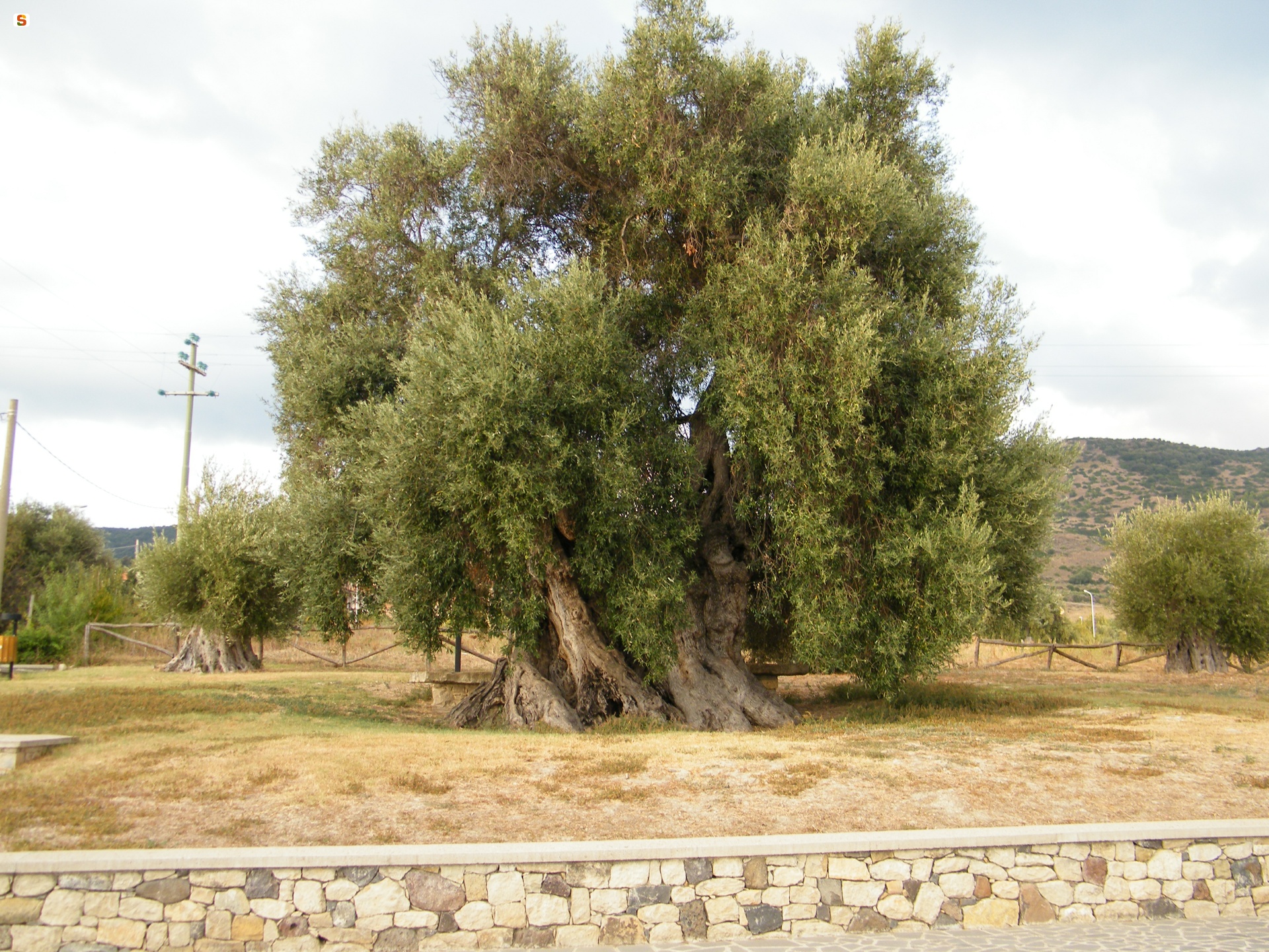
Two more rolling hills overlook the town: the hills of Giuerri and Santa Vittoria. The apex of the latter contains the remains of a mysterious building surrounded by a village where a sacrificial slab was found. The hills are covered by alternating pastures, cultivated fields, cork oak groves and Mediterranean shrubs. Shepherding produces exquisite cheeses, ricottas and meats; while the vineyards, almond orchards and groves of ancient, contorted olive trees produce renowned wines, almonds used in traditional sweets and excellent olive oil. Along the bank of Imbessu, surrounded by tunnels formed by ash trees, poplars and willows, stands the Spanish Fountain. A unique work of architecture and sculpting carved in multi-coloured trachyte by Laconian stonemasons and enveloped by the foliage of downy oaks and ivy in a fairy tale setting. It consists of a mask from the moth of which water once poured, flanked by two bas relief swans and other ornaments.
Traces of the area’s Neolithic past are abundant, especially obsidian chips and pottery fragments. The plateau is known as Bidda ‘e Perda, the country of stone. The name derives from the ruins of three Nuragic towers, anthropomorphic menhirs and rare historiated statue menhirs found in the area, which demonstrate a link to Sarcidano. The other hills are topped by eight Nuragic complexes, including the imposing and well-preserved Senis Mannu nuraghe, with a tholos roof. Another important site is the Casteddu nuraghe, shared with Asuni.
Setzu
‘‘Sitting’ at the foot of the Giara, a basaltic plateau that is home to an unparalleled natural oasis, Setzu is a small agro-pastoral village of about 150 inhabitants, the smallest in southern Sardinia and one of the smallest in the number of residents of the entire island. Its main income comes from farming and shepherding. It is known for its meats, cheeses, wine, mushrooms and snails: the foundations of local culinary specialties, which visitors can taste in mid-August, at the festivals of the Fregola and of Su Pani Indorau. The town name means ‘old’ (from su becciu, su belzu/elzu or s’etzu). The oldest of the nearby towns, it was part of the Giudicato of Arborea in the Medieval Period.
The town’s territory covers an area of about 250 hectares on the south-west slope of the Giara, as well as the rolling hills of the Marmilla. The town’s symbol is a unique species of wild horse: the Giara horse. They can be observed close up as they gallop through forests of cork, downy and holm oaks, wild olives and Mediterranean shrubs. The area is perfect for horseback riding and biking.
The town centre has retained its traditional look with stone Campidanese homes, characterised by arched doorways and internal courtyards (lollas). The buildings are arranged around the Parish of San Leonardo, built in the 13th century in Romanesque style. Fallen into ruin, it was rebuilt in the 17th century with obvious Baroque details. Next to the church, stands a bell tower with a square cross section: evidence of the original Romanesque structure. The church’s patron saint is celebrated in early November. The town’s other church is the Church of San Cristoforo. Setzu has close ties to tradition: the community’s most anticipated event is the Feast of Sant’Ignazio da Laconi in late August. The town’s cultural heritage includes the ex-grain bank and the Filo di Memoria multimedia museum, set up in 2011 in a converted historical residence in the heart of the town. It talks about prehistoric archaeology and the history of the town, using tools that include fables, across three rooms. The exhibition route leads visitors in a ‘live encounter’ with the Mother Goddess and Janas in a virtual voyage from 5000 to 3000 BC, a period during which the area was populated, as seen from the Domus de Janas, Domu ‘e s’Orcu and Grutta sa Perda. The remains of Nuragic towers testify to human presence during the Bronze Age. Numerous Roman ceramic items were also found near s’Uraxi Nuraghe. At Corte Muros, sections of walls and roofing dating to the same period were unearthed. While at Nuraxi ‘e Setzu, the ruins of a Roman Imperial village were found.

Siamanna
It was founded in the Roman Era in the upper section of the modern town, in Funtana e Susu, along the road from Usellus to Forum Traiani (Fordongianus), which is marked as Is Romanaius to this day. Siamanna is a small town of about 800 inhabitants, 15 kilometres from Oristano. It sits at the foot of Mount Grighine, which gave its name to the territory extending from the northern borders of Campidano and the historical territories of Barigadu and Upper Marmilla. The town’s name derives from s’ia, meaning ‘the road’, in reference to the Roman road. It was combined with the adjective manna (big), to differentiate it from the nearby, smaller town of Siapiccia, meaning ‘small road’. The two towns were part of the same municipality from 1947 to 1975.
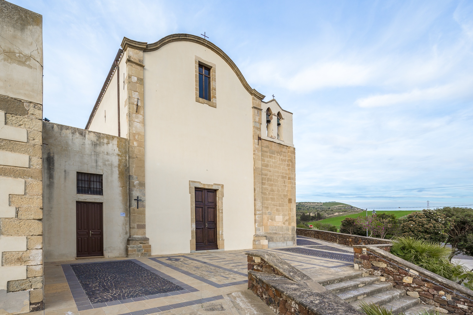
Its well-maintained historic centre has characteristic rural Campidanese structure: low houses with large courtyards and narrow roads. The 1512 Parish of Santa Lucia, whose original Pisan Romanesque layout consists of a nave and two lateral aisles, catches the eye in the city centre. In the first half of the 20th century, it fell into ruin and was torn down to be replaced by a new church. Only the 1745 bell tower dating to the Marquisate of Arcais remained standing. Its patron saint is celebrated on August 21 and 22 with two very popular events, the Festival of Su Pannu, brocade or damask cloth once given as a prize at festival race, and the Festival of Typical Products. The festival’s protagonists are Siamannese bread, grapes, cheeses and ricotta, typical of a town of shepherds and farmers cultivating cereals, fruit, olives and grapes. During the festival, the farmers cook ravioli according to traditional recipes for visitors. Religious celebrations are repeated on December 12 and 13 with a bonfire and a procession. On a hill about two kilometres from the town stands the Church of San Giovanni, a must-see. Possibly constructed in the 16th century and restored several times. Its patron saint is celebrated in late June with a dinner, music and traditional dancing. Adjacent to the church stands a nuraghe of the same name, the most important of nine surrounding the town, which predate by several centuries the Punic period and the extensive ‘Romanisation’. The other nuraghes are Auredda, Concu, Crogana, Curreli, Monte Qua Sigu, Paba de Soli, Pajolu, Pitzu Cau and Santa Vittoria.
Mount Grighine is over 700 metres in height and dominates the fertile lands around Siamanna, cut by valleys and crossed by the Mannu River. The mountain is a Palaeozoic island formed 500 million years ago. Its slopes contain outcrops of basaltic and granitic rocks eroded by the wind, alternating with, at times impenetrable, Mediterranean shrubs and ‘flashes’ of century-old holm and cork oaks, at Sa Cora e Is Ottus and Su Sruesciu Nieddu, for example. A refuge for bandits in the past, today, the mountain hosts an imposing wind farm.
Castello di Monte Acuto
The high plains of Monte Acuto, on the southern slopes of the Limbara range, are home to the remains of defensive fortresses and strategic outposts from early medieval times. Wounded during fierce battles and marked by the passage of time, Monte Acuto Castle sits at 500 metres in the Berchidda region and is a fine example. First documented after the XIII century, it enjoyed its most flourishing period when it was the seat of Giudicessa Adelasia di Torres and of archbishops, prelates and a variety of dignitaries. The castle was vied for first among the guidicati, and then fought over by Pisa and Genoa. It remained a vital structure until the Catalan-Aragonese conquest, after which it began to fall into disuse and declined to its current state. Perched on high, it watched over the roads travelled by convoys along the Mannu river valley, where merchandise was carried towards Terranova Port, modern-day Olbia, and connected with the Upper Gallura.
In order to get an idea of life at the castle you have to get through thick vegetation amongst which you’ll find a variety of pre-Nuragic and Nuragic sites: dolmen and menhir, huts and megalithic walls bear witness to the prehistoric remains you’ll come across along the trails. As you continue your ascent, you’ll see a sort of outpost, a guard tower, round, located a short distance from the fort. The castle’s main body, which seems to have had an elongated oval shape, is home to the remains of the walls. Tiles and bits of ceramic vases were found here too. At the top you’ll find the remains of a square room, the base of the tower (now gone), and next to that a partially interred cistern. From up here you can see the other systems of elevated outposts, each one visible to the other. You will go back to the life at the castle, imagining the chain of coded light signals created using metal items or mirrors that passed from one outpost to the other, or with bonfires when needed during the night.
After your trip to the castle, go and explore the many attractions in Berchidda, a lovely city with houses and neo-Classic palazzi set along narrow streets surrounded by a granite landscape shaped by the passage of time, dotted with oak and cork woods and Lake Coghinas. At Berchidda you can enjoy traditional cuisine, like the suppa cuatta, fine cheeses, sweets made with almonds and Vermentino wine. In mid-August they have the world famous Time in Jazz festival. In the town centre you can visit the church of San Sebastiano and the XVI century church of the Rosario and the wine museum at the feet of Sant’Alvara hill. In the surrounding countryside are prehistoric and Roman remains, like the bridge over the Silvani river.
Nostra Signora di Castro
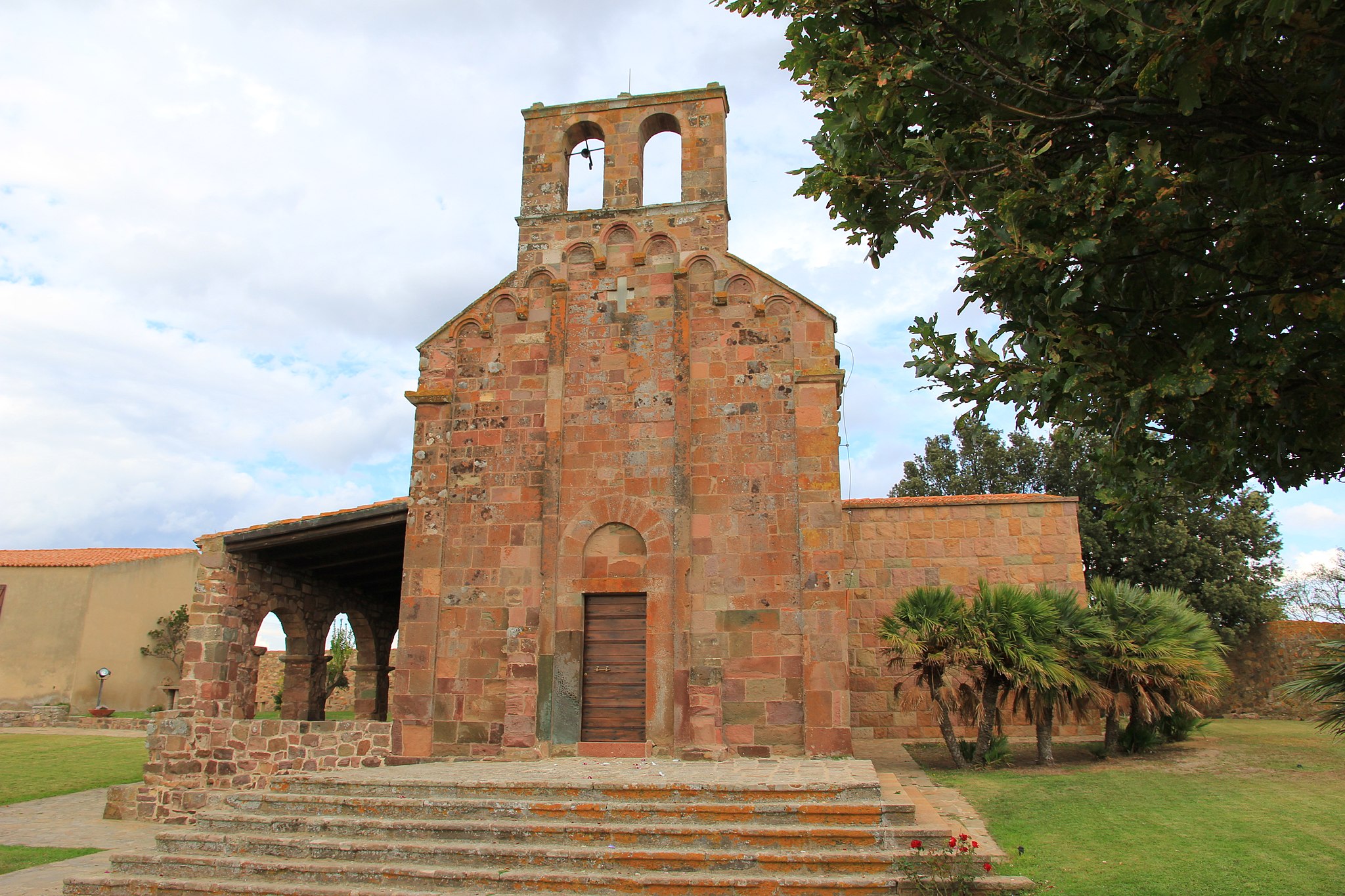
On a high plain on Monte Acuto, one of the most “Romanised” areas in Sardinia, a Roman-Byzantine castrum (castle) and medieval ruins dominate the plain below, home to the Coghinas river and lake. This is the setting around Nostra Signora di Castro, just five kilometres from Oschiri. Going up the hill of the small Romanesque church you will relive the history of the XI and XII century, when it was built between the banks of the lake, the castrum of Luguido, the village and the Castra castle, which lend their name to the temple. It was once the cathedral of the Castro diocese, which was done away with four centuries later, in 1508. No one knows the exact date of construction. The Liber judicum turritanorum claims it was founded by Mariano I di Torres in the XI century, at the same time as the Nostra Signora del Regno in Ardara, whose Romanesque-Lombardian style bears close similarities. Others think it’s consecration was linked to the cathedral of sant’Antioco di Bisarcio in 1164 or 1174.
The area around it has lodging for pilgrims, cumbessias, and a two storey building now used for exhibitions about the history of the sanctuary and the archaeological site. The church attracts many pilgrims, the courtyard comes to life on the Sunday after Easter for the Madonna di Castro celebrations. Once up the five stairs you will enjoy the light reflected by the blocks of trachyte used to make the building. They are graced with gradations of hues of intense pink to dark purple. Two pilasters face the door and divide the façade into three mirrors, each featuring three arches set on decorated bases. Inside is a single 11 metre long and 5 metre wide nave. The semicircular apse has a trussed wooden ceiling. To the left is a great door that was added at a later date. A parchment has survived from the Romanesque altar, now housed in the parish of Oschiri. It features St Restituta, an African martyr whose cult on the island dates to the High Middle Ages. Some graves in the surrounding area date to the same period.
In Oschiri, a town in eastern Logudoro at the feet of the Limbara and in the middle of a valley graced with Mediterranean shrubbery, oak and cork trees, are other religious buildings of the same period as the former cathedral. In the old town, near the parish church of the Immacolata is the Church of San Demetrio, in the countryside are the sanctuaries of San Giorgio, San Pietro, Santo Stefano and Nostra Signora di Othi. Low houses and narrow cobblestone streets are what characterise this rural village, where fine cheese, Vermentino wine and panadas are made. The surrounding area is home to Roman and Byzantine ruins, but also prehistoric remains like the 70 domus de Janas at the necropolis, the mysterious complex of Santo Stefano and 60 Nuragic settlements. The relics are on display at the MuseOs.
Biru 'e Concas
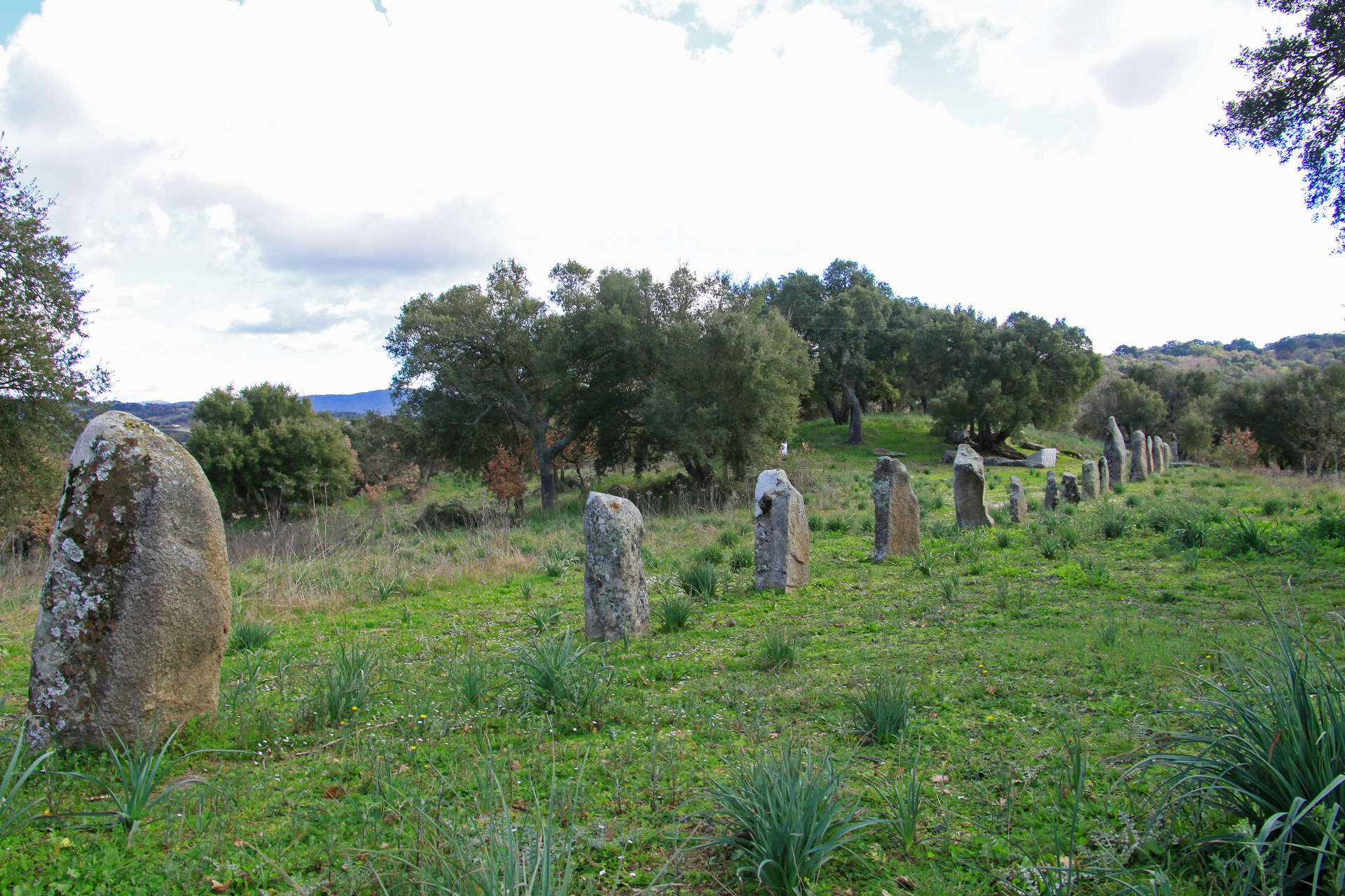
Right in the middle of the island is a place that exudes spirituality and provides food for thought. You will notice it when you visit the most extraordinary grouping of menhir in all of the Mediterranean basin. It is the archaeological park of Biru ‘e Concas, which literally means ‘trail of the heads’, commonly referred to as the Sardinian Stonehenge. Located a few kilometers from Sorgono, the town is nestled in the woods of the Mandrolisai region, the westernmost point of the Barbagia. Inside you will see two hundred huge sculpted boulders that have been worn down to an oval shape. The oldest, proto-anthropomorphic, date to the late Neolithic (3500-2800 BC), while the more elaborate stylized ones, anthropomorphic, date to the Eneolithic (2700-1700 BC). In essence, the megalithic monuments are elongated sacred rocks that were once embedded (perdas fittas) and served as phallic symbols for fertility to evoke the Mother Goddess, a primordial Nuragic divinity that somehow echoes the mythical and heroic figures of the forefathers.
Nestled among pine, chestnut and hazelnut trees and still spread about as they were in origin, you will see some of these forms of prehistoric cultural art alone or in pairs, trios, other times set in circles or rows of twenty. Thirty of them are lined up in double rows, like warriors defending an area of worship, another 170 are flat on the ground pointing west, towards the sunset, broken up, the result perhaps of the holy war against the idolatry of the Barbagians declared by Pope Gregory in the VI century during the Christianisation of inner Sardinia. The two hundred menhir discovered in the late XX century were remarkably important for Barbagia, who had only counted some fifty before the big find. And they are all concentrated within an area of five hectares, very near the famous Sanctuary of San Mauro, a complex erected by Benedictine monks as though they were attempting to exorcise the holy, phallic granite statues all lined up along the transhumance routes towards the plains. Who were the makers of the great stones? Is there some connection to Celtic or Breton megalithic tradition, or where they autochthonous, original? And why such a vast concentration of menhir near Sorgono? These are questions still being asked and the object of debate among Sardinian archaeologists.
Not far from the menhir is a hidden spring that could indicate a well for the worship of water, the confirmation of an intertwining of styles and architecture between the Neolithic and Bronze Ages. All around are remains of round huts, perhaps a Nuragic village, while further on are two nuraghe, one with a corridor, the majestic Talei, the remains of a Giant tomb and a dolmen.

Villa Piercy
An estate dating to the late XIX century has, over the decades, morphed from being a farming estate to a nature oasis with a verdant garden featuring a wide variety of plant species. Set over four hectares among the hills of Marghine and the Campeda high plain, it is the legacy left by a Welsh engineer who came to Sardinia in 1863 to help design the (Cagliari-Olbia and Chilivani-Porto Torres) railroad line that was being built by the Italian-English company known as the Royal Sardinian Railroad Company. The celebrated figure was Benjamin Piercy, a rich and powerful man who fell in love with Sardinia, where fortune smiled on him until he collapsed during a banquet and died in 1888. In exchange for the work on the largest public works done (until then) in Sardinia he received several terrains in the Bolotana area. There he invested more than a million lire, a vast fortune in those days, to construct a modern company that was defined a “monument to agriculture.”
On the premises of the Badde Salighes estate (the Valley of the Willows) he built a majestic English style villa, his residence, where he lived in luxury and lavishly entertained fellow Brits and Italian friends. They say that Umberto of Savoy, the soon to be King of Italy, was a frequent guest. The rural three storey, square residence was built between 1879 and 1882. The building was topped with four towers covered with metal domes topped with an iron pinnacle. Inside the residence you will see paintings embellishing the ground floor rooms. After a 2010 renovation it was opened to the public along with the gardens, something of a botanical garden that reflected Piercy’s love of nature. Strolling among maples, holly, chestnut trees, holm oaks and downy oaks, you will also admire exotic species, the legacy of the British engineer's travels to various parts of the world. In the garden there is a libocedro, Himalayan tuja, Spanish fir, Balearic box, Lawson cypress and other rare plants. The park is also in English style, with a swimming pool surrounded by trees just a short distance from the villa.
Piercy’s legacy was left to his son and then expropriated in the mid-XX century. It included the lovely villa, the garden and even a small town, Chilivani (part of Ozieri), an important stop along the railroad. The Mediterranean’s largest animal husbandry concern was begun on the thousand hectares of his estate. Many workers worked and lived with their families in the Badde Salighes and Padru Mannu, where a dairy equipped with modern technology was built. It stands to good reason that Piercy’s name is closely linked to the nascent intensive agriculture and animal husbandry of Bolotana, a town surrounded by fertile fields and steeped in rural traditions, including the art of carpet weaving.
The Monte Baranta Megalithic Complex
Huge boulders create an impenetrable 100 metre long and 3 metre high wall. It’s the great wall of the fortress built by pre-Nuragic settlers to defend their wide fertile valley, and it is one of the most remarkable and massive settlements from the III millennium BC in all of the Mediterranean basin. It sits on the slopes of Mount Baranta just 3 kilometres from Olmedo, an important industrial/agricultural town in the heart of the Nurra region. Also known as su Casteddu, the fortress dates to the Copper Age (2500-2000 BC) and was constructed with massive megalithic structures following the natural contours of the terrain. Protected by walls, the fortress is comprised of a wall-tower and a group of rectangular huts. Everything here is imposing, built with large rocks and boulders: even the horse-shoe shaped tower is huge, six and a half meters thick and nine metres high. It sits perched on an outcrop of trachyte over the valley below.
At the far end of the wall is a sacred area with a megalithic circle where worship and sacrifices were carried out. It is made up of 80 standing straight up in a 10 metre wide circle. Between the rocks are characteristic menhir, one split into two pieces, another whole lying on a rocky raise, perfectly polished. East of the wall you will also find the remains of a small village. Seven large, rectangular, multi-room dwellings have so far been identified.
The Monte Baranta megalithic complex was a busy place, bustling with the military, religious and civic activities of the pre-Nuragic people who lived there. You can feel a touch of insecurity in the air, a fear of attack from the outside that urged the settlers of the Monte Claro culture to seek protection inside an impenetrable construction.
Just after its construction, Su Casteddu was lived in for a relatively short period of time, as shown by the paucity of period relics found during digs and the fact that the area of worship remains unfinished. The site was repopulated during the Early Bronze Age and then, more sporadically, during Nuragic and Roman times. Proof of the vitality and density of the population can also be seen in the surrounding area, in the Olmedo region that counts some twenty nuraghe, including those of Mount Ortolu (a corridor construction), Masala (tholos) and sa Femina, remarkable for the fact that is was built in town.
Monserrato
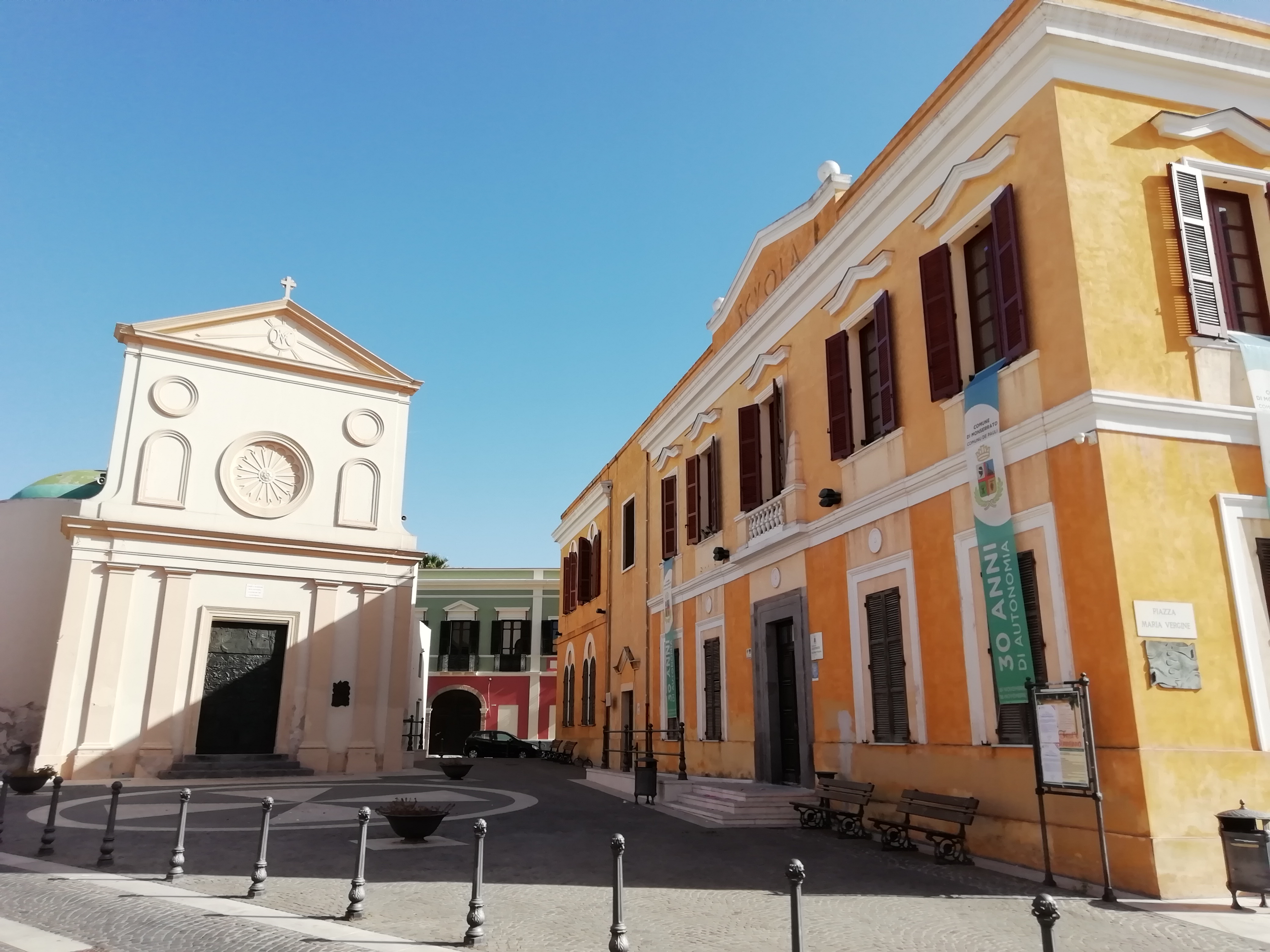
Monserrato lies in the southernmost part of the Campidano province, near the Molentargius-Saline Regional Park, within the metropolitan city of Cagliari. Monserrato is a city with 20,000 inhabitants, whose inhabited area, through the municipality of Pirri, is seamlessly joined with that of the capital, from which it became independent via a referendum in 1991. In Sardinian, it is known as Pauli (swamp), already the name in medieval times. It then became Paùli Pirri. In 1881, the name changed to Paùli Monserrato. Just seven years later, via royal decree, this became Monserrato, deriving from the Madonna of Montserrat.
The old town is characterised by narrow streets overlooked by typical Campidanese houses in Ladiri (mud-brick), with Spanish loggias and wooden portals. The winemaking tradition lives on, as is testified by Sagra della vendemmia (Grape Harvest Festival) at the end of September. Its communal winery is the oldest in Sardinia (1924), with nuragus, monica, moscato and nasco wines produced here. From the end of the 20th century, construction was remarkable, with new and modern neighbourhoods being built. Along the road to Sestu, the Cittadella Universitaria was built, being a vast complex connected to the city by the Ponte Strallato (bridge) on the state road 554, the only one on the island. Inside the citadel is the Museo Sardo di Antropologia ed Etnografia (Sardinian museum of anthropology and ethnography). The other main exhibition is the Museo delle Ferrovie della Sardegna, dedicated to the construction and operation of historic stations and railway lines, with an area in which old-time steam locomotives and vintage carriages are kept. There is also the Trenino Verde, a tourist service that departs from Monserrato and heads to Mandas and Isili.
To be admired in the heart of the city is the parish church of Sant’Ambrogio (whose patron saint is celebrated on 7th December), in late Gothic-Catalan architecture, built between the late-15th and early-16th centuries. Whilst there was originally one nave, today the interior has three, with the central one being wide and tall, composed of pillars that unite in ogival arches. The side aisles are barrel-covered with six chapels on each side. On the high altar in gilded wood and polychrome marble (1705), scenes of peasant life and Christian symbols are carved in bas relief. The baptismal font is the work of Catalan craftsmen of the 15th century. Particular and unique in Sardinia is the conformation of the diagonal buttresses of the façade. The earliest information on the Church of Santa Maria de Pauli dates back to the 12th century. Its Greek cross layout is surmounted by a 19th-century dome. It is only open in September to celebrate the Virgin of Montserrat, just prior to the harvest rituals. Within are housed works by artist Gianni Argiolas, including the ‘Painting of the Procession’. Another illustrious local is painter Cesare Cabras (1886-1968), whose works are on display inside the town hall. A stand-out amongst the Monserrato traditions is the luxurious traditional women’s clothing.