
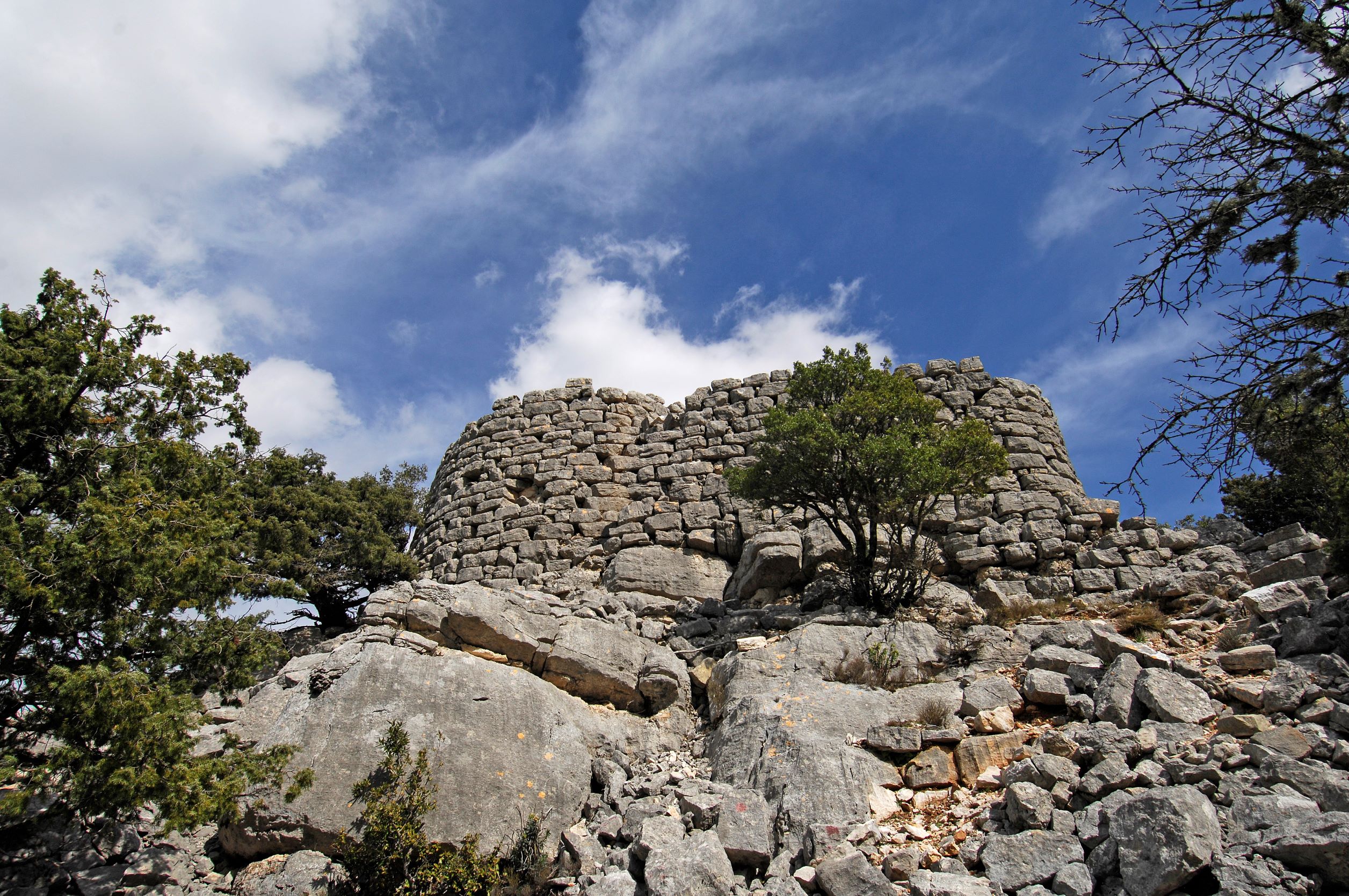
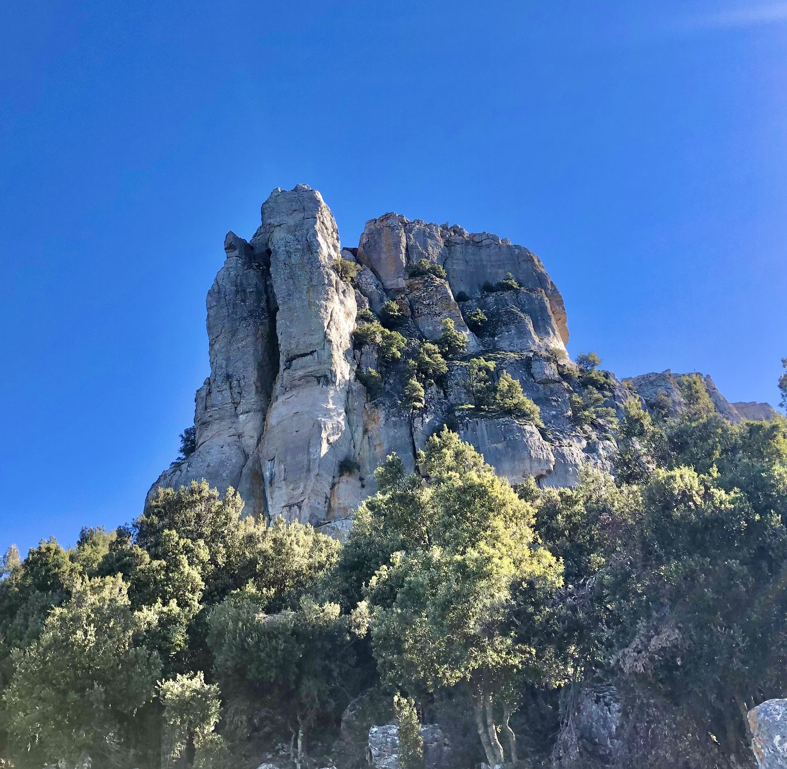
Nuraghe Mereu
It stands on a rocky outcrop overlooking one of the deepest canyons in Europe and, thanks to its light limestone blocks, it stands out in the heart of a dense forest. The nuraghe Mereu stands at a height of 835 metres on the Supramonte of Orgosolo. The inhabitants of this Barbagia village call it nuraghe intro ‘e padente, or ‘the nuraghe inside the wood’. The Mereu is, in fact, difficult to see if observed from below and from a distance, as it is surrounded by the forest of Montes. However, once you reach it, you will be able to admire a breathtaking landscape, especially the walls of the spectacular gorge of Gorropu to the north-east. Then, to the south, you can see the outlines of the Supramonte of Orgosolo and that of Urzulei.
The nuraghe, built entirely from limestone blocks found on site, has a complex structure, with a trilobate layout, a keep and two secondary towers connected by a curtain wall. Still standing are the main tower with a tholos roof, still intact and about five metres high, and the bastion on the west side. The original entrance was on the south side and led into a corridor that is still partly accessible and at the end of which there is a connecting room between the keep and one of the towers, now partially collapsed. The third tower, however, is now a ruin. The stairwell, to the left of the entrance and leading to the upper terrace, is also partially remaining. To the west of the fortress, you will notice several traces of the village huts, while, hidden inside the wood, there are a few Tombs of Giants, linked to the same settlement.
800 metres further on, heading north-east, you will reach the single-tower nuraghe Presethu Tortu, also known as nuraghe Gorropu due to its closeness to the gorge. It is also built in white limestone and is located on the edge of a rock wall, which conditioned its structure. On the east side you will notice a bastion more than three metres high, still in good condition, while the tower is currently six metres high. Like the Mereu, the Presethu Tortu is surrounded by traces of huts. The path between the two nuraghi crosses the dense forest, marked by stones purposely placed along the way. A visit to the two nuraghi ‘guarded’ by the forest of Montes will take you into the thousand-year-old wood of sas Baddes, one of the most ancient expanses of holm oaks in Europe, occupying a thousand hectares. A short distance away, a visit to the most famous natural monument, the gorge of Gorropu, on the border between the Barbagia area of Orgosolo and the Ogliastra area of Urzulei, is a must. The canyon with its majestic walls, a kilometre and a half long, was created by the patient erosion of the river Flumineddu, and it is a destination for trekking enthusiasts from all over the world.
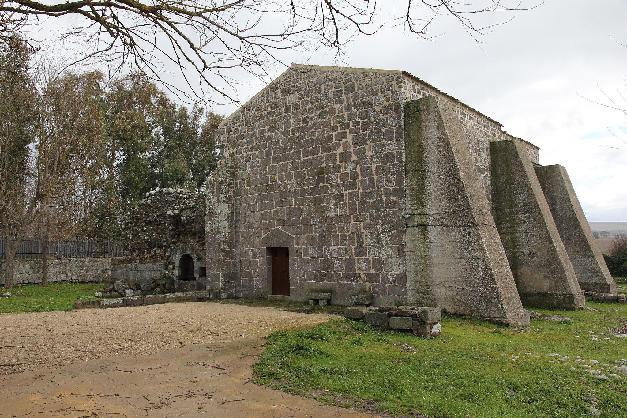
Santa Maria di Corte
It is the first and main Cistercian church in the Sardinian territory, evidence of the age of the Judicates, made up of wars, alliances, religious ferment and monasteries around which medieval village life revolved. Above all, it is the only remaining part of an abbey that reached its maximum splendour and then decline and ruin over just a few centuries. The church of Santa Maria di Corte is also known as Santa Maria di Cabu Abbas, from the name of the locality, a valley in the territory of Sindia - three kilometres east of the village - rich in springs and water sources. The sanctuary has lived two lives: the first began with the foundation commissioned by the judge of Torres, Gonario II, following an encounter with Saint Bernard of Clairvaux. The term 'corte' (court) contained in the name is, in fact, the result of the sovereign’s direct desire to build the abbey. Gonario asked and obtained, from the abbot, the arrival of monks and workers to build the complex and, in exchange, he granted large portions of land between Planargia and Marghine.
Between 1147 and 1149, the abbey was built and consecrated. The monastery became an economic centre, attracting farmers and artisans thanks to the ‘granges’, self-sufficient farms managed by the monks, but sources tell us that shortly thereafter, already at the end of the 13th century, the abbey complex was in complete crisis. The church and monastery were abandoned around the middle of the 15th century: the abbey was closed down by the Pope and the buildings were almost completely demolished to make room for other buildings. The sanctuary’s second life began at the beginning of the 17th century, when the renovation of the original transept began and new rooms were added, ‘converting’ the surviving building from scratch into a church. Thanks to the excavations and the evident traces on the ground, it is possible to reconstruct the layout of the entire building made from trachyte and dark basalt: the church had three naves, a crux commissa and a quadrangular apse. The cloister opened on the south side, surrounded by spaces used by the monks. Today, you can admire the southern part of the transept with two chapels, a vaulted room - perhaps used as a sacristy -, and part of the raised choir. On the right side, you will notice three buttresses, between which a portal with a rounded arch opens up between the first and second buttress. The chapels are barrel vaulted and each of them contains a single lancet window.
The abbey was destroyed also as a result of the popular belief that the monks were hiding rich treasures there. According to a legend, there is a second underground church, with a golden statue inside it protected by mysterious rituals preventing it from being found.
The celebration of Santa Maria di Corte is deeply heartfelt by the people of Sindia: on the eve of the celebration, su Izadolzu takes place and is a common vigil in which food and drink is offered. 8 September is the real day of the celebration, with a solemn procession, dances and shows.
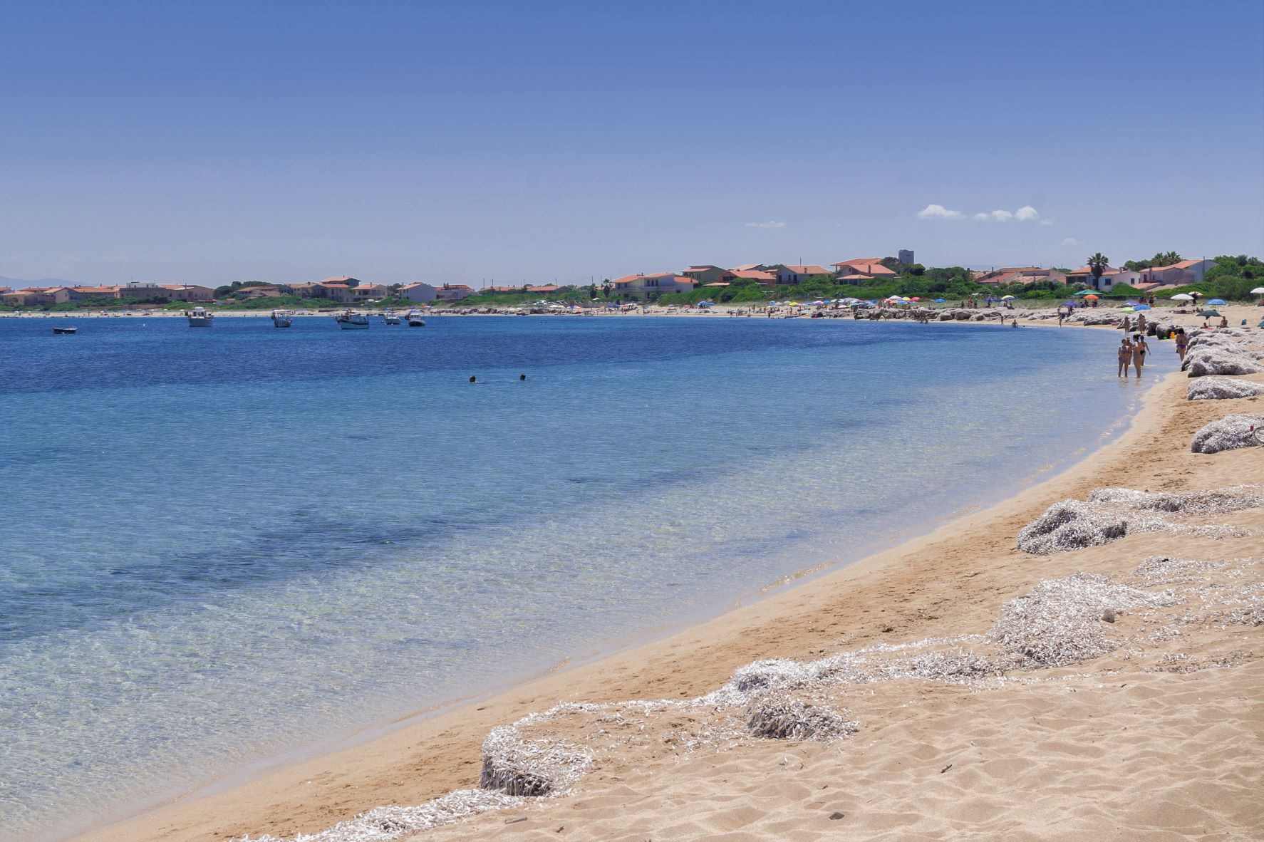
Sa Rocca Tunda
A wide expanse of pale grey sand, crystal clear waters and soft sand dunes behind it, a view that you will never want to stop observing, in absolute tranquillity. Sa Rocca Tunda stretches along the foot of Capo Mannu, in the northern part of the Sinis peninsula, next to a small village of little houses and dirt roads in the San Vero Milis area. The beach is about a kilometre long and part of the protected marine area of Sinis and is washed by a turquoise sea that takes on more vibrant colours offshore. The left side of the beach is delimited by the promontory of Capo Mannu. In front of it, the islet of sa Tonnara appears and, to the right, there is the cliff of su Crastu Biancu, beyond which you will have a view that stretches from the northern coast of the Oristano area all the way to the ‘costa dei grifoni’ (coast of the griffons) at Capo Marargiu. On the opposite side, behind the promontory, another rocky offshoot stands out, dominated by the remains of the Capo Mannu tower, built in the Spanish period (16th century).
A refreshment area is the only service in this wild and uncontaminated place. In fact, Sa Rocca Tunda is ideal for those seeking relaxation and tranquillity away from the chaos of the most crowded holiday resorts. Large spaces and shallow waters make it suitable for families with children. The transparency of the sea also attracts snorkelling enthusiasts, while the Sale Porcus pond behind it, populated by various species of birds - including pink flamingos - invites you to dedicate some time to birdwatching.
Around Capo Mannu, you will find numerous other unmissable beaches, which will take you on a real tour of scenic beauty. Almost in continuity with sa Rocca Tunda, towards the tip of the promontory, you will find su Pallosu, with its colony of cats. On the opposite side, a sandstone ‘barrier’ is located in the open sea a few dozen metres from a golden beach, creating an unusual landscape: it is Sa Mesa Longa, a real natural swimming pool with emerald green waters. To the south, in front of the village of Mandriola, lies the long beach of Putzu Idu, with its very shallow, blue and incredibly transparent waters. A spectacular cliff surrounds s’Arena Scoada, where rocks smoothed by the waves emerge, as well as sand mixed with quartz crystals and a sea reflecting shades of green and blue. Just before sunset, you can stop near the Capo Mannu lighthouse, at the foot of another Spanish tower, Turr’e sa Mora, to admire an unforgettable play of colours with a view of the island of Mal di Ventre.
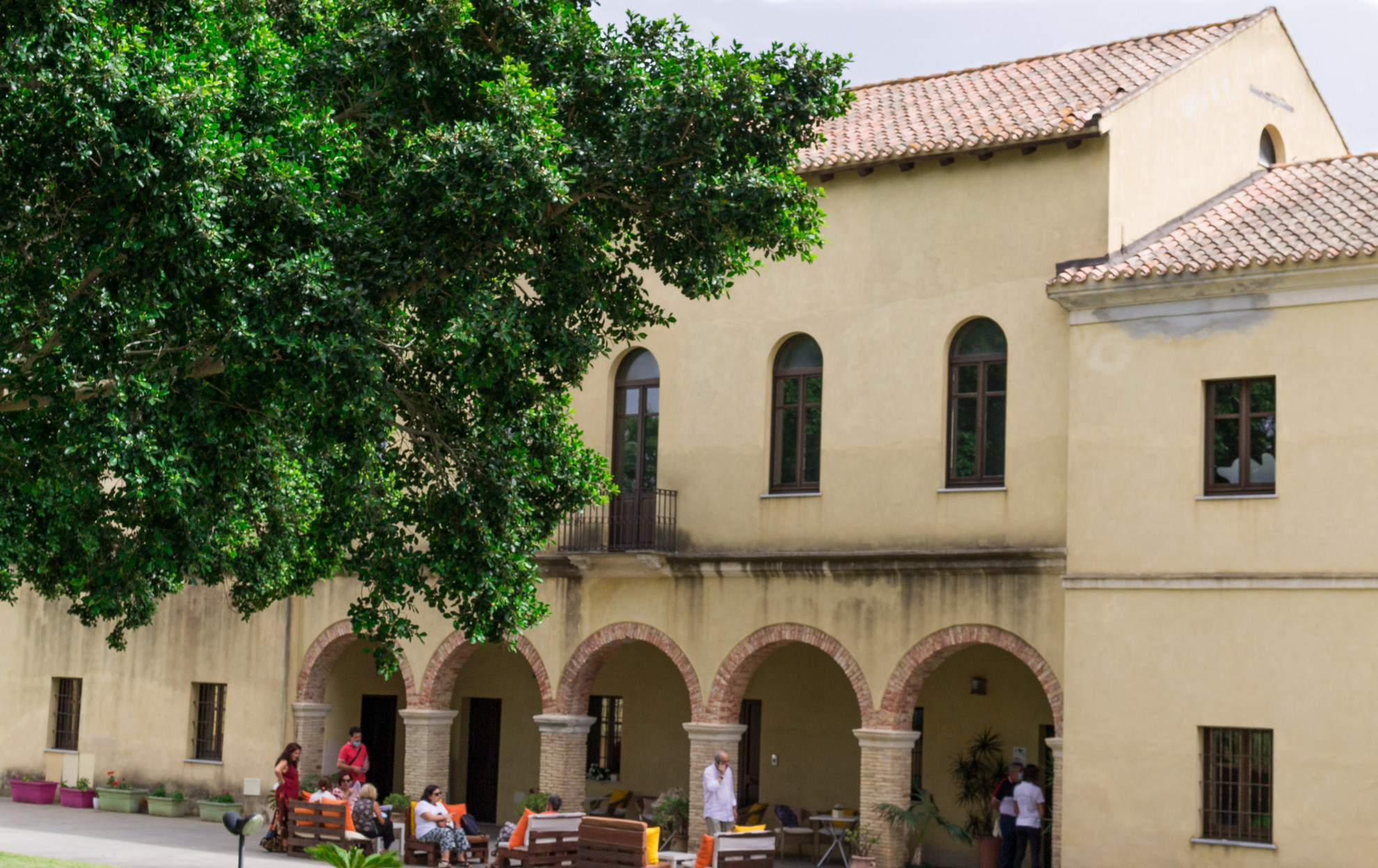
Casa Spadaccino
It was originally a railway station, then a manor house, after which it was abandoned for decades. Today it is a cultural centre. These are the four lives lived by Casa Spadaccino, a historic building a stone’s throw from the sea, at su Loi, a locality in the territory of Capoterra. It was constructed in 1873 by the French mining company of Petin et Gaudet, which held a concession in the inland mountains. It was located at the end of the ‘road of the Genoese’, an ancient coal merchants’ road on which a railway was installed. The building served as the terminus station for convoys loaded with iron extracted from the mine. In the 1930s, it became the heart of a thriving farm, surrounded by vineyards, vegetable gardens and orchards. The area was transformed into a large, colourful garden, where cutting-edge cultivation techniques were applied, so much so that it earned itself the nickname of su spantu, ‘the wonder’, which still identifies a small village not far from su Loi.
The urban development of the Capoterra coast led to the sale of much of the land, resulting in the decline and closure of the company. Casa Spadaccino - which owes its name to its last owner - was abandoned for decades, before being acquired and renovated by the Municipality of Capoterra. Today, the Laguna di Santa Gilla environmental and sustainability education centre is located inside it, along with the Laguna Museum (MuLAG), and it also hosts cultural events and shows. The exhibition is a journey through the natural and ecosystem-based aspects of the lagoon, also known as the Stagno di Cagliari. It also looks back at its relationship that evolved over time with the inhabitants of Capoterra. There are plenty of educational workshops and thematic programmes aimed at raising awareness about the lake environment.
The building consists of a single-storey central body, with an attic and an entrance portico with five arches, to which two other buildings, identical to each other, are attached. A large, sheltered garden offers peacefulness and a space for outdoor activities and events. You can combine a visit to the ‘house’ with an experience in close contact with nature on the banks of the lagoon. The lagoon environment extends for 1300 hectares between Cagliari and the territories of Assemini, Capoterra and Elmas. The wildlife that populates it is varied and fascinating for birdwatching enthusiasts, who can count on dedicated stations: you will see herons, hawks, black-winged stilts and above all pink flamingos, which have nested here for decades. You can walk along the paths around the lagoon, or ride on horseback or on a mountain bike.
Monte Novo San Giovanni
A limestone ‘tower’ with spiers of up to 70 meters high, surrounded by rare endemic floral species, from which to enjoy a spectacular 360-degree view of both the Supramonte and Gennargentu massifs. That describes the spectacle of Monte Novo San Giovanni, a natural monument that stands at 1306 metres above the Montes forest, in the Orgosolo region, known as the 'village of murals' of the Barbagia of Ollolai. Seen from afar, it looks like an enormous bastion with an almost regular shape, a bit like the 'heels' of Ogliastra, but in reality the upper layer is broken into rocky blocks divided by deep cracks that are home to such endemic species as the ribes sardorum.
The view from here spans from the Gennargentu to the Supramonte of Orgosolo and Urzulei, from monte Corrasi to the gola di Gorropu, then to the Baronia coastline along the sea. You’ll see the full length of the Montes forest and the centuries-old sas Baddes oak woods, one of Europe’s oldest. At the top of Santu Juvanne, as it is known here, are two wooden huts. On the right looking south-east you’ll see Monte Fumai, another tall limestone tower vaguely shaped like a pyramid. The top reaches 1316 metres in height and it shares its geological origins with Santu Juvanne. The trail that leads to the natural panoramic terrace is accessible to all and an easy walk. It starts at the Montes forestry station and goes by the Funtana Bona natural springs, the source of the Cedrino river, and which, as its name suggests, is a source of pure clean water. The trail, which can also be enjoyed on a mountain bike, is shaded by oak woods and majestic holm oaks. Now and then you might even spot a mouflon, a local breed of mountain goat. Other local fauna includes wild boar, wild cats, dormice, martens, hares and foxes, while eagles, ravens and peregrine falcons circle in sky around the peaks of Monte Novo San Giovanni and Monte Fumai. Near the base of the tower the forest thins out, the rugged landscape comes alive with asphodels and rock roses and begins to open up: you may even see grazing herds along the bends before you reach a small section with stone steps that finally lead you to the summit.
The Montes forest bears traces of ancient settlements, like the Mereu and Presethu Tortu nuraghes near the sas Baddes woods, and the two Giants’ tombs at sa Senepida. At the feet of Monte Fumai are the remains of a pastoral village known as Norculanu, the setting of legends and popular tales that you can hear as you stroll along the streets of Orgosolo, decorated with murals.
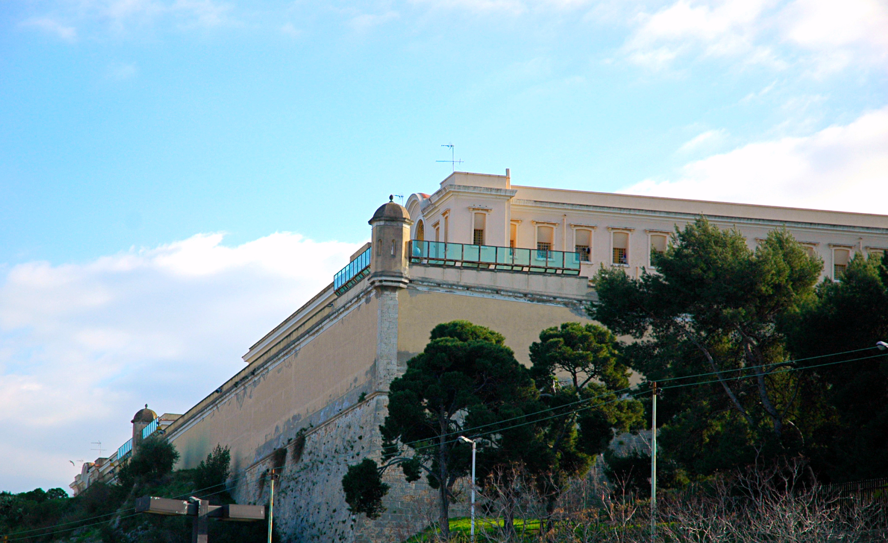
Former prison of Buoncammino
It is the most imposing urban building in Cagliari and it stands on top of a panoramic hill surrounded by tree-lined avenues and ‘terraces’ with a view of the entire city. The prison of Buoncammino, like the surrounding urban area, owes its name to the nearby church of San Lorenzo, originally dedicated to the Virgin of Buoncammino. At the top of a high ground, at an altitude of one hundred metres, it occupies a rectangular surface area of 15 thousand square metres.
The complex, made up of six buildings, was constructed in two phases: the first around 1855 and the second between 1887 and 1897. Before Buoncammino, prisoners were held in the Tower of San Pancrazio, with its entrance in the nearby Castello district, and in annexed and surrounding buildings. The first nucleus emerged to integrate the prison facilities in use at the time, but due to overcrowding and the hazardous conditions they were experiencing, it was decided that the new prison should be extended and transformed into a real ‘citadel’ that could accommodate from 500 to a thousand prisoners, with the consequent permanent closure of the San Pancrazio complex. The current appearance is the result of further additions of buildings, which took place around the 1930s.
At the corners of the perimeter wall, you will notice octagonal bartizans, covered by a small segmented dome. Two more are up against the building at the front of the complex, where the prison entrance archway opens up. Once you cross the threshold, you will see a terreplein that can be reached via two flights of steps opposite each other. Here you will find the management building and an additional porter’s lodge that leads to a courtyard, from which the wings leading to the cells branch off.
In many areas of the prison, you will recognise neoclassical details: rounded arches, cross vaults, decorations and paintings in the cornices and ceilings. Buoncammino stands in a ‘strategic’ position, in the outskirts of the town (at the time of construction), not far from the fortifications of the Castello district and on a high ground with a view of both the east and west sides of Cagliari. During its 120 years of ‘service’, no prisoner ever managed to escape. The prison was closed in 2014, as it no longer complied with the regulations on prison conditions. Since then, it has been opened up to the public, as a stop on cultural tours, particularly on the occasion of the FAI Days (FAI is the Italian National Trust), with a view to turning it into a permanent museum.
Viale Buoncammino boasts some of the city’s most panoramic viewpoints. While walking along it, you will cross through the nineteenth-century Porta Cristina, dedicated to the wife of King Charles Felix, and you will come to Piazza Arsenale, where the Citadel of Museums is located, and Piazza Indipendenza, where you can venture into the little lanes of the Castello district and visit the Tower of the Elephant, Palazzo Regio (Royal Palace), Palazzo di Città and the Cathedral of Santa Maria.

Bau Muggeris
Next to the first weir on the Flumendosa, the river with the highest flow rate in Sardinia, there is a large lake reflecting shades of blue, surrounded by archaeological legacies, ‘ghost’ villages and breathtaking landscapes. Bau Muggeris was originally the name of a gorge, where, according to tradition, the muggeris, meaning the women of the village of Villagrande Strisaili – in the area of which the reservoir is located - went to do their household washing. Today, it is the name of a dam, which was built, and of the artificial basin that emerged following its construction, which took place between 1928 and 1949. The first construction projects date back to 1915 but, shortly after the work began, it came to a sudden halt, when funds were redirected towards coal mining in Sulcis. Three power stations were built downstream, exactly at the ‘cascades’ in the river, which could produce up to 130 million kilowatts/hour at full capacity, equal to about one third of the electricity produced in the entire Italian peninsula in mid-20th century.
The ENEL (National Electricity Board) village also emerged next to the power station at the first ‘cascade’: as well as housing for the workers, it was equipped with a school, a shop, warehouses and a children’s camp. It was abandoned at the beginning of the twenty-first century, following the progressive automation of the power station. Today it is a ghost village, where vegetation has regained the upper hand and where flocks venture out to graze from time to time. In addition to providing power to the power stations, the basin of Bau Muggeris – with its 63 million cubic metres of water - guarantees an essential water supply for agricultural and drinking purposes and prevents the overflowing of torrential rivers in the area, which flow into the reservoir. The lake is rich in fish fauna: carp, pike, eels and above all trout. Three species can be identified, of which two were artificially introduced and one is a native species, the macrostigma sarda, the subject of recent protection interventions to avoid its extinction. You will be able to follow paths suitable for trekking and mountain biking around the shores of the lake, alongside the inlets, enjoying splendid views of the Gennargentu massif and the Buttes of Ogliastra.
A short distance from the ENEL village, you can also admire the remains of the nuraghe su Chiai and the Giants’ Tomb of sa Conca ‘e Pira Onne. Among the waterways that flow into the lake, there is also Bau Mela, ‘creator’, a few kilometres further north, of a spectacular show of nature: the natural pools of Bau Mela.

Castello di Baratuli
It is an important witness to the system of surveillance and defence of the Campidano territory in medieval times and it is also literally surrounded by fascinating legacies from pre-Nuragic and Nuragic times. The castle of Baratuli stands on the top of Olladiri in the territory of Monastir and was built on a previous settlement dating back to the Bronze and Iron Ages. It was built around the middle of the 12th century in the name of the judges of Cagliari, with the aim of monitoring the southern part of the Campidano area. It later passed to the Gherardesca family, who also owned the castles of Acquafredda and Gioiosa Guardia between the current territories of Siliqua and Villamassargia. After the fall of Count Ugolino, one of the most famous and controversial characters of Dante’s Inferno, it ended up in the hands of the Republic of Pisa, which destroyed it in the early 14th century, perhaps to avoid it being conquered by the Aragonese. Along with the castle, the village of the same name located in the valley, near the country church of Santa Lucia, was also destroyed.
By observing the foundations and the wall base of the fortress - a hexagonal layout with a paved courtyard in the centre - you will also see the remains of a barrel-vaulted cistern and other structures, probably used as storehouses and accommodation. On the other side of the courtyard, opposite the entrance, are the foundations of the main tower, which could be reached via a flight of steps. Beyond the courtyard, a furnace and traces of the curtain wall can be seen. From the castle, there is a 360-degree view, allowing you to see Monastir, as well as the towns of Ussana to the north, Serdiana and Dolianova to the east and Sestu to the south.
At the base of Mount Olladiri, next to the path leading to the top, you will notice cavities dug out of the basaltic rock: this is the necropolis of Is Aruttas, consisting of five Domus de Janas, dating back to between 3200 and 2800 BC. Four tombs are made up of an entrance, an anteroom and a burial chamber, while one of them was never completed and only has one room. Not far from the site are the remains of a pre-Nuragic settlement, after which a large Nuragic village was built with numerous huts. The surrounding area reserves other surprises: next to Olladiri, there is another mountain, Zara, on which you can see the ruins of a large settlement frequented between the pre-Nuragic age and the Roman period. There are two funeral areas, including a necropolis with two Domus de Janas, side by side, which, due to their unusual features, have been named is ogus de su monti, ‘the eyes of the mountain’. At the top, you will notice a monumental flight of steps, leading to a sacred area with altars and wells, while on the slopes of the hill there are traces of circular huts. This is where a sandstone artefact was found and some have identified it as a wine press, perhaps the oldest in the Mediterranean and an exceptional piece of evidence of wine production, a widespread activity in the Nuragic age. Today, it is kept in the council chamber of the Monastir town hall.

San Pantaleo - Martis
The most shining example of Italian Gothic style in Sardinia, before the spread of Catalan style, has been standing for centuries, challenging the precarious stability of the ground, thanks to continuous restoration actions. The church of San Pantaleo stands just outside the town of Martis and was built on a rocky spur overlooking the Rio Carrucana valley. There is no certain information on its foundation, but it is thought that it dates back to the first quarter of the 14th century. Two centuries later, the first restoration work was carried out, with reconstruction and consolidation, which were then repeated during the 19th century. Finally, in 1920, its deconsecration took place, due to the risk of a sudden collapse. Since 1988, the church and the rock ‘plinth’ on which it rests have been the subject of stabilisation and renovation work, aimed at ensuring the survival of the building.
It has a basilica-type layout with three naves - although it originally had a single nave - with cross vaults in the central nave and ribbed vaults in the side naves, separated by cross-shaped pillars that support pointed arches. The presbytery is closed by a quadrangular apse, which ends overlooking the edge of the rocky spike. The façade has retained a good part of its decorations, with the exception of the rose-window, which has nevertheless maintained its two-tone array, with alternating ashlars of black trachyte and light limestone. On the left side of the façade, you will notice a trace of the original entrance. The quadrangular bell tower is also still in good condition: the lower part dates back to the first construction of the church, while the upper part was rebuilt in the 16th century. The walls retain several decorations: on the north side, near a single-lancet window, you can see some engravings depicting crosses and a circle with floral elements. On the opposite side, there is an inscribed star, while you can spot traces of frescoes on some walls. The church also contained a precious oil-painted altarpiece, depicting the ‘miracle of San Pantaleo’, created by Andrea Lusso in 1595 and now on display in the parish church dedicated to San Giuseppe.
The church is shrouded in myths and legends: there are stories of miracles inside it, secret environments hidden under the foundations and ruins of ancient temples dedicated to the worship of the water on which it was built. The presence of an underground aquifer is, in fact, one of the causes of the landslide on the right side of the spur.
Just over a kilometre to the east, you can visit another unusual site: the Petrified Forest of Carrucana, featuring silicified fossils of tree trunks, dating back to volcanic phenomena that occurred twenty million years ago. In the opposite direction, you will find the waterfall of Triulintas, set in an almost fairy-tale landscape, with woods, lakes, little wooden bridges and the remains of an ancient mill.

Santa Maria della Neve - Cuglieri
It was the first Sardinian church to obtain the title of minor basilica, it contains a remarkable stylistic variety of decorations and furnishings and is the scene of various rituals of one of the most exciting events during Holy Week on the Island. The church of Santa Maria della Neve stands over the town of Cuglieri from the top of the Bardosu hill, in the eastern part of the village. Its origin is steeped in legend: it is said that, in the 13th or 14th century, a group of fishermen from Cuglieri found a mysterious stone simulacrum of the Madonna - with a golden flower in her hand - on the beach of Santa Caterina di Pittinuri, and they decided to take it to the church of Santa Croce, which was the village’s parish church at that time. The oxen that pulled the cart with the statue in it continued their journey without stopping at the church and instead climbed up the Bardosu hill. Once at the top, it was impossible to make them move. The locals interpreted what happened as divine will and built a temple there. The name also apparently comes from a miracle: the church was originally supposed to be dedicated to Santa Maria del Fiore, but after the attempted theft of all the precious furnishings by a gang of thieves, sudden heavy snowfall prevented the criminals from escaping, allowing the treasure to be recovered.
The first news of the presence of a sanctuary on the hill dates back to the 15th century, but the current building is probably a late seventeenth-century reconstruction, the subject of a great deal of renovation and extension work over the centuries that followed. You can admire a Neo-Gothic style façade, built in 1913 and divided into two orders, above which there is a ‘double inflection’ tympanum, slightly set back to leave room for a terrace. Two small bell towers with spire crowning elements frame the façade, while there are two marble bas-reliefs on the sides of the portal, depicting the arrival of the statue on the hill and a further miracle, which occurred in 1824, when lightning struck the statue, leaving it unharmed. The single-nave hall is divided into bays with a barrel vault and four chapels on each side. In the presbytery, a ‘fan-shaped’ altar stands out, above which there is a dome with pendentives and a tholobate. Among the furnishings, you will notice a chestnut wood choir, marble statues depicting Saint John the Evangelist and Saint Paul and the painted stone statue of Our Lady of the Snow. The basilica is home to one of the historical brotherhoods of Cuglieri, that of the Rosary, of seventeenth-century origin. The brotherhood tends to the celebrations of feast days and helps with the Holy Week rituals: in fact, here, on Friday, sa contra rughe, a heavy black wooden cross, is hoisted up and acts as a support for the crucifix, the protagonist of the ritual of su ingravamentu, the crucifixion. In the afternoon, on the same day, another exciting ritual takes place inside the basilica: the deposition.