
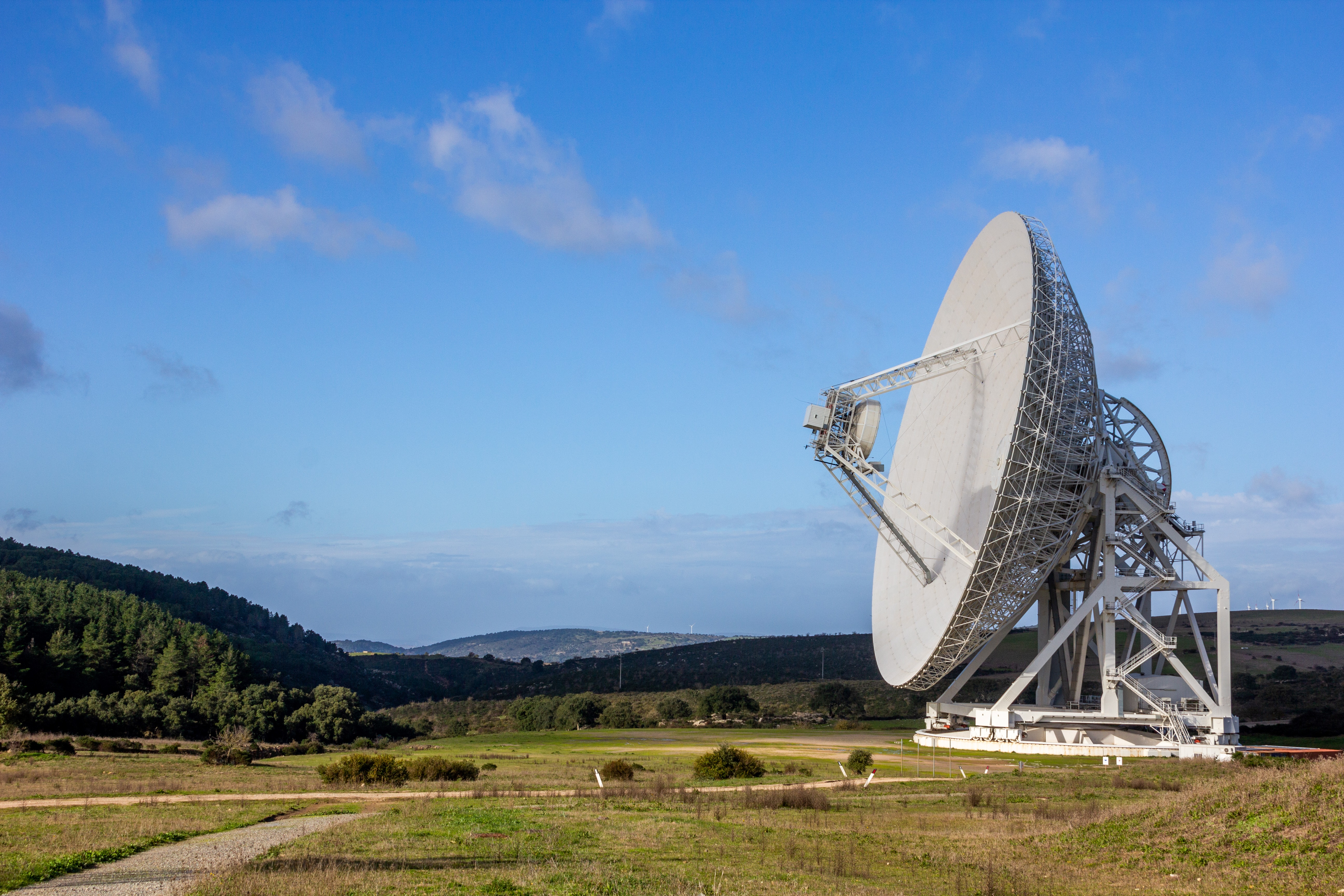
Sardinia Radio Telescope
It is a technological jewel, constantly updated and essential for revealing the mysteries of space and allowing science to make important steps forward. The Sardinia Radio Telescope is a single-dish radio telescope, located in Pranu Sanguni, nine kilometres from the village of San Basilio and 40 km from Cagliari. The site, managed by the Cagliari Astronomical Observatory on behalf of the Italian Institute of Astrophysics, was inaugurated in 2013 and emerged as a research tool also available to the Italian Space Agency. Among the celestial objects that it is able to observe, there are galaxies, black holes, planetary nebulae, neutron stars and pulsars. You can admire a dish with a 64-metre diameter, composed of over a thousand aluminium panels that can move independently, thus allowing the antenna to adapt to the different focal positions of the receivers.
Not only physical elements: the telescope is also involved in the search for signals defined as non-natural, or coming from extraterrestrial sources. The Sardinia Radio Telescope is, in fact, involved in the SETI – Search for Extra-Terrestrial Intelligence - project, through the Breakthrough Listen programme, along with other telescopes from around the world. Furthermore, through the Italian Space Agency, the San Basilio telescope also collaborates with NASA and will be able to provide its contribution to guaranteeing communications during the next missions to the Moon and Mars, as well as tracking satellites and monitoring space debris.
Today, the Sardinia Radio Telescope is the most powerful Italian radio telescope and one of the largest in Europe, as well as one of the most technologically advanced telescopes in the world. This is also thanks to its new ‘glasses’: in 2023, Mistral, a receiver with 415 detectors that operate simultaneously, was installed, allowing us to observe celestial phenomena such as galaxy clusters and gas filaments between clusters, consequently deepening our knowledge of the dark matter of the universe.
During a visit, which you can book through the Cagliari Astronomical Observatory website, researchers, technicians and communicators at the observatory will tell you about all the interesting facts and various aspects of the research project, before taking you for a walk to see the radio telescope up close, located at an altitude of 700 metres, and observe the sky, trying to imagine new and exciting astronomical discoveries.
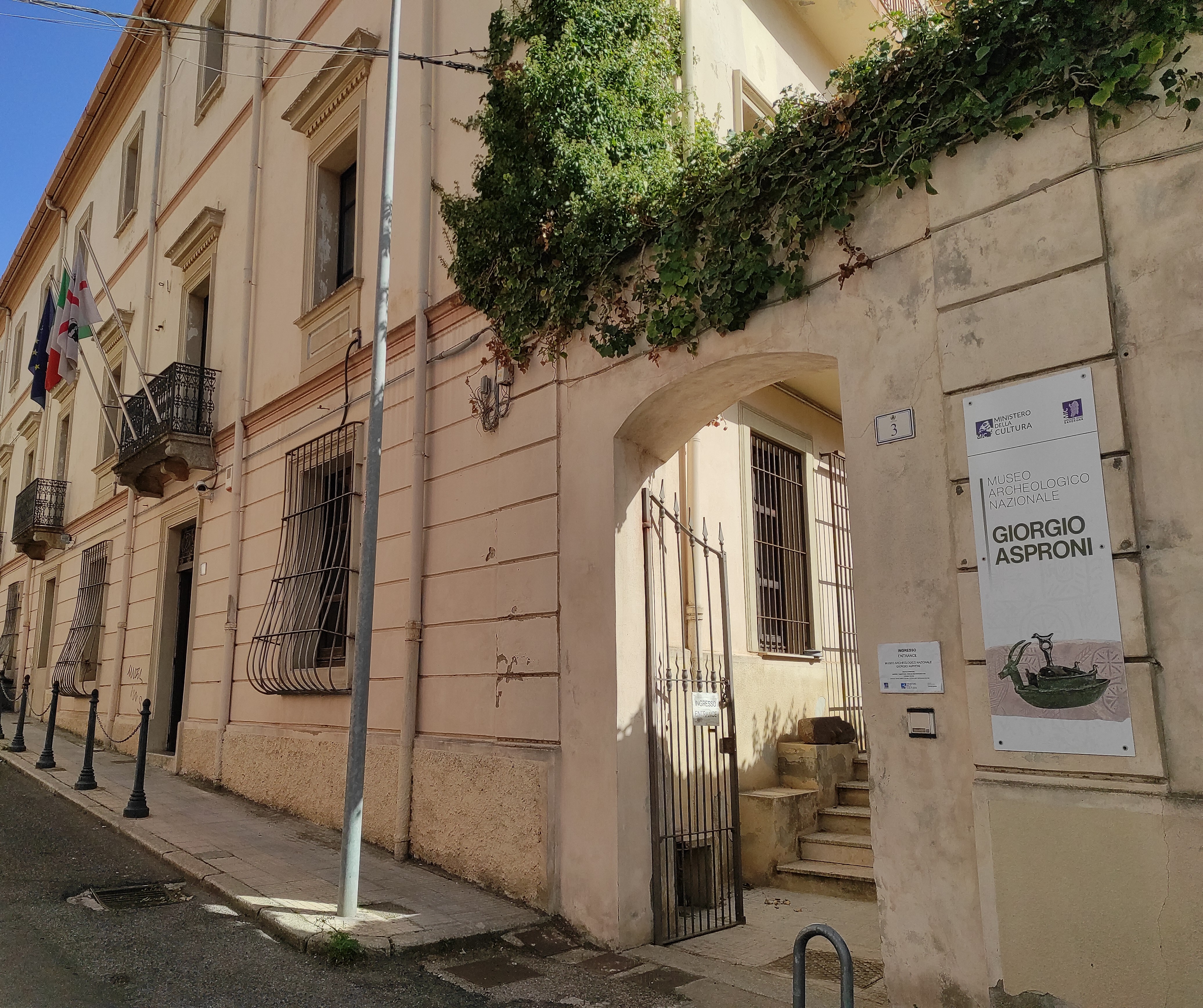
'Giorgio Asproni' National Archaeological Museum
It is one of the sources of pride in a city that, thanks to its artistic and cultural ferment, has earned itself the title of ‘Sardinian Athens’. The National Archaeological Museum of Nuoro, dedicated to the intellectual and political figure of Giorgio Asproni, is located in the historic centre of the main city of Barbagia, a stone’s throw from the Cathedral of Nostra Signora della Neve. The exhibition is located inside a historical 19th century neoclassical-style building that belonged to Asproni himself. It was inaugurated in 2002, but contains a collection with a decidedly older history: the collection dates back to the early 20th century, when Canon Mauro Sale entrusted the objects in his possession to the Municipality of Nuoro. Thanks to donations from private individuals and the activity of the Gruppo Grotte Nuorese, the ‘speleo-archaeological civic museum’ opened in 1978 and, after closure and integration of the collection following further excavation campaigns, led to the emergence of the present-day museum.
The exhibition maintains its dual archaeological and palaeontological nature: starting from the evidence of vertebrates from Monte Tuttavista in Galtellì and from Grotta Corbeddu in Oliena, you will find yourself travelling through time, with Palaeolithic and Neolithic artefacts, objects dating back to the Copper Age and a rich Nuragic collection, including artefacts from the sacred well of Su Tempiesu in Orune and from the village of sa Sedda 'e sos Carros in Oliena. Regarding the latter, you can admire the reconstruction of its spectacular circular well. There is no shortage of evidence from the Phoenician-Punic and Roman eras, with materials also recovered from the depths of the sea. The journey ends with the Middle Ages, represented by artefacts found in the Castello della Fava in Posada. One of the main attractions is the reconstruction of the tomb and of the funeral objects of Sisaia, a woman who lived in the early Bronze Age (2200-1800 BC) in the territory of Dorgali, famous as evidence of the most ancient cranial drilling achieved on the Island.
One of the fascinating features of Nuoro is its varied cultural attractions. Walking for a few hundred metres, you will reach the MAN – Museum of Art of the province of Nuoro. Inside, works by the greatest Sardinian artists, like Nivola, Lai, Delitala and Ciusa, coexist with contemporary trends. In the outskirts, there is the ethnographic museum, where you can gain a deeper knowledge of Sardinian material culture, with objects, masks, clothes, musical instruments and toys. A stop at the birthplace of the most famous Nuoro-born personality in the world, Grazia Deledda, is a must. It has now become the Grazia Deledda Museum. Lastly, the open-air museum in Piazza Satta, ‘created' by Costantino Nivola, is worth a visit.
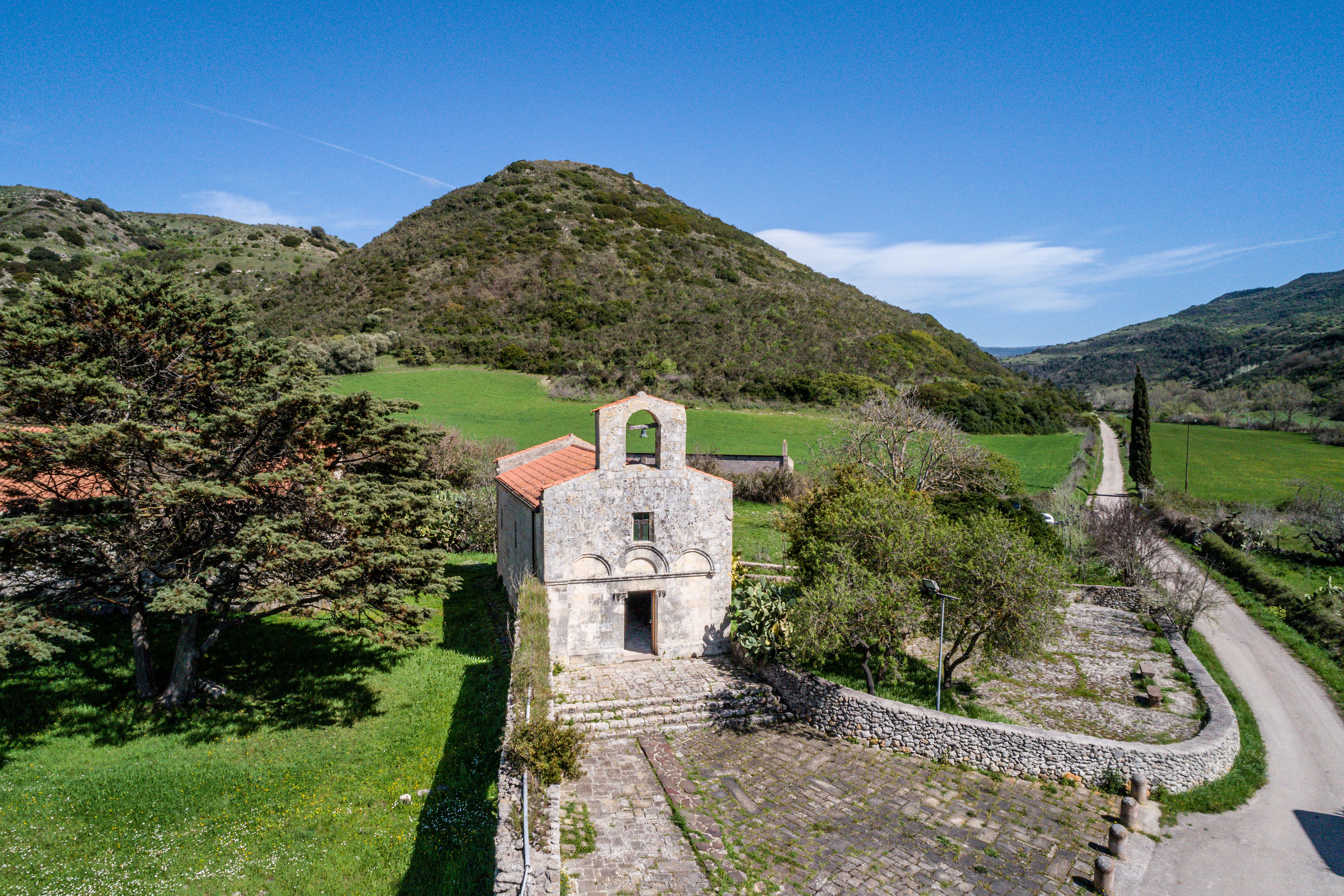
Santa Maria di Cea
The church, the enclosed courtyard and accommodation for the hermits - known as the ‘hermitage’- belonged to a monastic order, as confirmed by medieval sources, but it is not known with certainty which one. Furthermore, even the date engraved on an ashlar on the façade is the subject of debate. These two elements are enough to describe the aura of charm and mystery surrounding the church of Santa Maria di Cea, located in a valley six kilometres from Banari. The area was an important centre of wine production in Roman times, after which it was abandoned for ten centuries. In fact, sources mention the village of Seve and the priory of Santa Maria as existing in the 12th century. It was commonly thought that the convent belonged to the Vallombrosians; in reality, however, no medieval document mentions it among the estates of the Benedictine order. The association began to appear in the 16th century, when the monastery was joined to that of San Michele di Salvennor, coming back to life after centuries of abandonment.
One theory, supported by inscriptions and a tau symbol engraved on the façade, as well as documents from the 14th century, suggests that it belonged to a military-knightly order, that of the Knights Hospitaller of Altopascio. On the façade, there are three epigraphs that are difficult to interpret: one, in particular, shows a date, but the last two characters are quite unclear, making it difficult to read: it could be 1250, 1260 or 1261. The building style is Romanesque, constructed with limestone ashlars; the apse faces east and the façade is divided by a cornice. In line with the main portal, you will notice a window and the bell gable. On the north side, there is a second entrance, called the ‘holy door’, through which only the monks entered. It has is a single-nave layout with a trussed roof dating back to work carried out in 1973, perhaps respecting a previous model, although the idea that the church hall was originally barrel-vaulted cannot be ruled out.
The courtyard contains the remains of structures from the old monastery: traces of room perimeters, an oven to the north and, in the centre, the well, around which you will see sections of the original cobblestone flooring.
The feast of Santa Maria takes place around 8 September and lasts two days, with processions and celebrations in the churchyard. Another opportunity to visit Banari and taste its typical products is the renowned festival of the golden onion, in July.

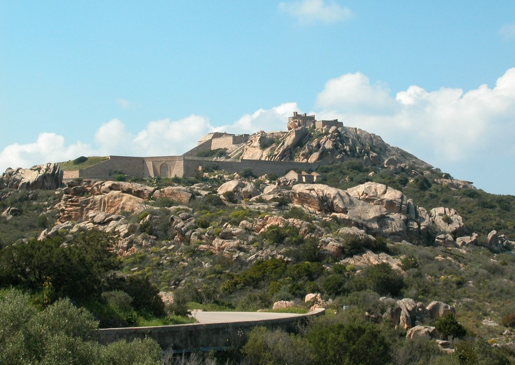
Castle of Pedres
Sought-after because of its strategic position, it bears witness to the historical period of the Judicates and the Pisan and Aragonese dominations. It is one of the symbols of Olbia and, along with the Basilica of San Simplicio, one of its most important medieval monuments. The Castle of Pedres stands on the top of a granite rock about 140 metres above sea level, five kilometres south of the town in the Gallura region. According to fourteenth-century sources, downstream, a few hundred metres south of the castle, there was a village called Villa Pedresa, which has now disappeared. It is assumed that the manor house was built in the thirteenth century, during the ‘dominion’ of the Visconti of Pisa. Around the middle of the 14th century, it was entrusted to the hospital friars of San Giovanni di Gerusalemme and it then passed into the hands of the Aragonese. It was later abandoned starting from the next century.
To go up to the castle, you can follow a path with a flight of steps built in recent times, following a route that may have been used by soldiers during the Second World War. Halfway along the path, you will see the ruins of a small watchtower built in the same period as the castle. At the top, you can admire the remains of the fortress: the keep has a quadrangular layout, with two remaining floors - out of four original ones - and is about ten metres high. It also has an underground cistern. The ‘surviving’ corner is formed by two sides that belong to a second cistern and traces of two rectangular rooms. The castle was surrounded by a double wall: the first enclosed a fortified area, where the garrisons were probably located; the second protected the keep.
On the right, you will notice another building. It dates back to the Second World War and may have been an anti-aircraft post, a casemate or a storehouse. Thus, structures built six hundred years apart coexist on the top of the rock. You’ll take another big leap in time by walking three hundred metres to the west: here, you’ll find the fascinating Giants’ Tomb of su Mont’e s’Abe, built in two phases: during the first phase - dating back to the Early Bronze Age (1800-1600 BC) - the tomb was built with a gallery grave; later on, it was transformed into a Giants’ Tomb, with a semicircular exedra, a corridor and a burial chamber.
The archaeological heritage of Olbia, which also includes the nuraghe riu Mulinu, the sacred well of sa Testa and the Roman villa of s’Imbalconadu, as well as evidence that is still visible in the town, is ‘narrated’ in the Archaeological Museum, on a small island next to the port. Speaking of the sea, after visiting the town, you really must spend some time on the splendid beaches of the Olbia coast, overlooking the island of Tavolara.
Fortress of Monte Altura
Many people consider it one of the most beautiful military works of 19th century Europe. It defended a sea, crossed by Napoleon, Admiral Nelson and Domenico Millelire almost a century earlier, and today it tells its story and offers an enchanting view of the Maddalena Archipelago National Park. The military fortress of Monte Altura stands in Palau, on the hill of the same name to the west of the residential area, a few steps away from the picturesque village of Porto Rafael. It was part of a complex of three military structures, along with the fortresses of Capo d’Orso and Barragge. It was built in record time, in just two years, between 1887 and 1889, using locally-extracted granite stone. This choice had two advantages: faster construction times and, above all, a ‘camouflage’ effect: the buildings in the complex seem to blend into the rocks of the hill.
The three fortresses dominated a strategic space, seriously at risk in the event of a conflict between the European powers. The territory was monitored 360° up to the coast of Arzachena to the east and Corsica to the north-west. In particular, Monte Altura had an anti-ship defence function, equipped with armaments that were cutting-edge at that time. The complex is surrounded by a series of bastions that stand on the granite ridges. After crossing a path surrounded by fragrant Mediterranean scrub, you will pass the entrance once delimited by a wooden door - now made of iron - and you will then see the buildings that survived naval battles, two world wars and decades of abandonment. Fortunately, Monte Altura was never bombed. Lodgings, warehouses, depots, washhouses, a munitions depot and the monumental ramp that leads to the shooting range seem suspended in time, as if they were ready to return to service at any time. The fortress has two levels, connected by a staircase: the upper level contained the armaments, while the other structures found a place on the lower level. The battery of Capo d'Orso, located near the famous rock, defended the port of La Maddalena during the Second World War, but was unable to prevent the tragic sinking of the cruiser Trieste in April 1943. The fortress of Baragge, on the other hand, is located halfway between the other two, overlooking the present-day town of Palau. Also built on two levels, it is now covered in vegetation.
After your journey through history, you won’t be able to resist discovering the jewels of the Palau coastal area: the city beaches of Palau Vecchio, Porto Faro and Spiaggia dell’Isolotto. To the west, beyond the captivating stretch of sand of La Sciumara, the ‘intimate’ beach of Nelson and the little white houses nestled in the greenery of Rafael await you.
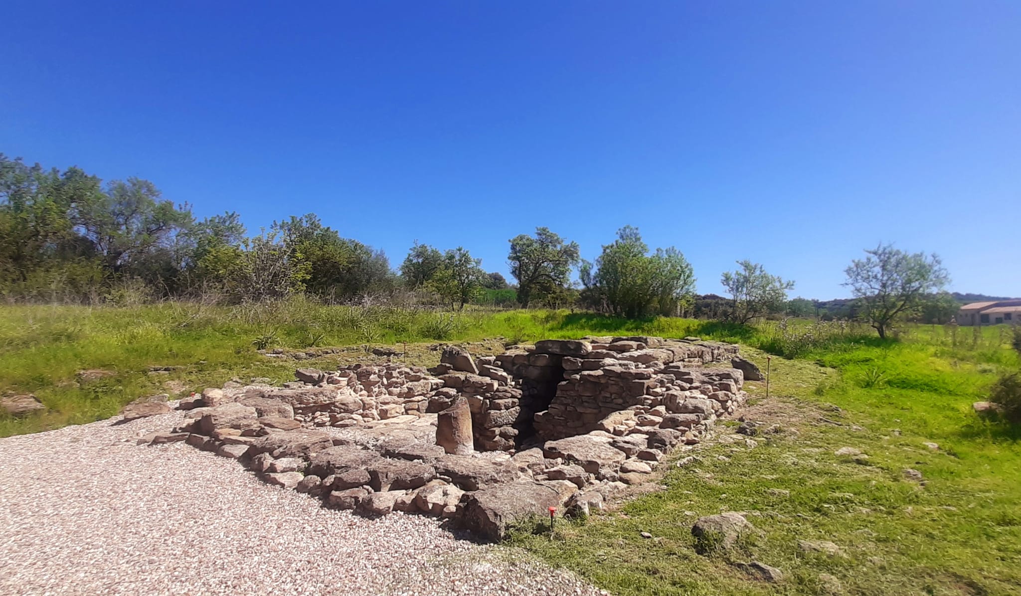
Sacred Well of San Salvatore - Gonnosnò
An aura of spirituality has surrounded it for thousands of years, from the Nuragic era through the Punic period, up to the Middle Ages. In fact, it gets its name from a church, which has now disappeared, that probably stood next to it. The sacred well of San Salvatore is located on top of a hill to the south of Figu, a hamlet of Gonnosnò. Excavations have shown that the area was intensely frequented for a long time for religious and funeral purposes. The first structure dates back to the Recent and Final Bronze Age, between the 13th and 11th centuries BC, and it consists of a rectangular, paved atrium, from which you can enter the stairwell, through a trapezoidal entrance. From here, a staircase of about 4 metres will take you to the room, partially carved into the rock, with a sub-circular layout and a tholos roof.
The material used to build the well is marl, easily found in the surrounding area. The blocks are evenly squared, hammered and arranged in staggered rows. You will notice some unusual elements in the atrium: the paving made of tuff pebbles, a baetyl and a lithic cist. This is what remains of its ‘restructuring’ for religious purposes carried out in the Punic period, perhaps around the 3rd century BC. In the northern part of the area where the excavations took place, traces of masonry have emerged: they are thought to belong to the Church of San Salvatore, of which only the name of the place had remained until now. The outline of the exposed masonry parts would seem to suggest that an apse-shaped building existed in the past. A large necropolis has emerged in the surroundings, where about ten tombs of people who died at a young age have been investigated. The objects found in the necropolis date back to a period between the 12th and 15th centuries AD.
After visiting the well, you can also explore another fascinating piece of Nuragic evidence, just 700 metres from the well. This is the necropolis of Is Lapideddas, consisting of four Giants’ Tombs, one of which is curiously smaller than the others, also built using squared blocks of marl. Tomb 3 is the best preserved: you will see a large burial chamber with a paved floor, several rows of the walls and part of the east wing of the exedra. The excavations also unearthed older and different types of tombs: six burial pits, perhaps dating back to the culture of Monte Claro, testifying that the area was already used for funeral purposes in the pre-Nuragic era.

Porto Cervo
Undisputed capital of the Costa Smeralda, Porto Cervo is a district of Arzachena, a town in the Gallura area, with just a few hundred residents. In the summer, it becomes an extraordinary procession of hundreds of yachts and famous personalities: it is quite likely that you will find yourself in the square, shopping with stars of the cinema and the television. Every day is a continuous stream of engagements with the international jet set: parties, social events, sports events, golf in particular.
The seaside village emerged around a natural cove that resembles a deer. The old port dates back to the 1960s, when Prince Karim Aga Khan IV, captivated by the beauty of this stretch of coastline, had a brilliant idea when he decided to buy the lands of this part of Gallura and, together to the Swiss-French set designer Jacques Couelle, and later assisted by several Italian architects, he brought life to this paradise of international elite tourism. In the 1980s, the work to build the new tourist port began, which is now one of the biggest and best equipped in the Mediterranean (700 boat moorings), headquarters of the Costa Smeralda Yacht Club, organizer glamorous and prestigious regattas. Walking along the docks, you can admire the moored yachts of rich, famous personalities or you can watch them as they leave the port.
The town of Poltu Celvu (in the language of the Gallura area) was built high up on level ground with respect to the port. From Piazzetta delle Chiacchiere to the Sottopiazza there is a series of alleys, windows, balconies, built in typical Costa Smeralda style, as well as shops and boutiques selling prestigious designer items, while, all around, you will find the most prestigious restaurants, luxury hotels, the most fashionable clubs, at the centre of the coast's nightlife, and splendid villas climbing up the surrounding hills, nestled in the Mediterranean scrub. During the design stages, the prince and his collaborators came up with the idea of creating architecture that would maintain continuity with the typical Gallura architecture as much as possible, blending perfectly into the environment: it was the key to success. On the subject of architecture, remember to take a look at the splendid Stella Maris church, the work of architect Michele Busiri Vici, which dominates Porto Cervo Marina.
A few steps from the touristic centre are some breath-taking beaches. The expanse of soft, white sand of the Grande Pevero is lapped by the turquoise, blue and green reflections of the sea, flanked by granite rocks shaped by time, and by Mediterranean scrub. Behind it there are well-kept golf courses hat make the resort a popular destination for golfers. Separated by a promontory, you will find the Piccolo Pevero, a beach that is less than half the size of its 'older sister'. Offshore you can admire the islets of Li Nibani, 'the seagulls'. Two kilometres further south are other wonders: the Romazzino and the Principe beach (in honour of the Aga Khan). On the opposite end of the 'emerald' promontory, you will be entranced by delightful coves, including Cala di Volpe and Liscia Ruja. Further south, don't miss the paradise of Cala Capriccioli, beaches of fine, light-coloured sand, protected by yellow, pink and reddish granite rocks. The name Gallurese means 'goats', and refers to a pair of huge, polished round boulders that form various coves. The beach to the east is ideal for families, while the western side is formed by the beaches of 'Pirata' and 'delle Tartarughe'. The panorama is enhanced by the islands of Soffi and delle Camere and the islet of Mortorio.
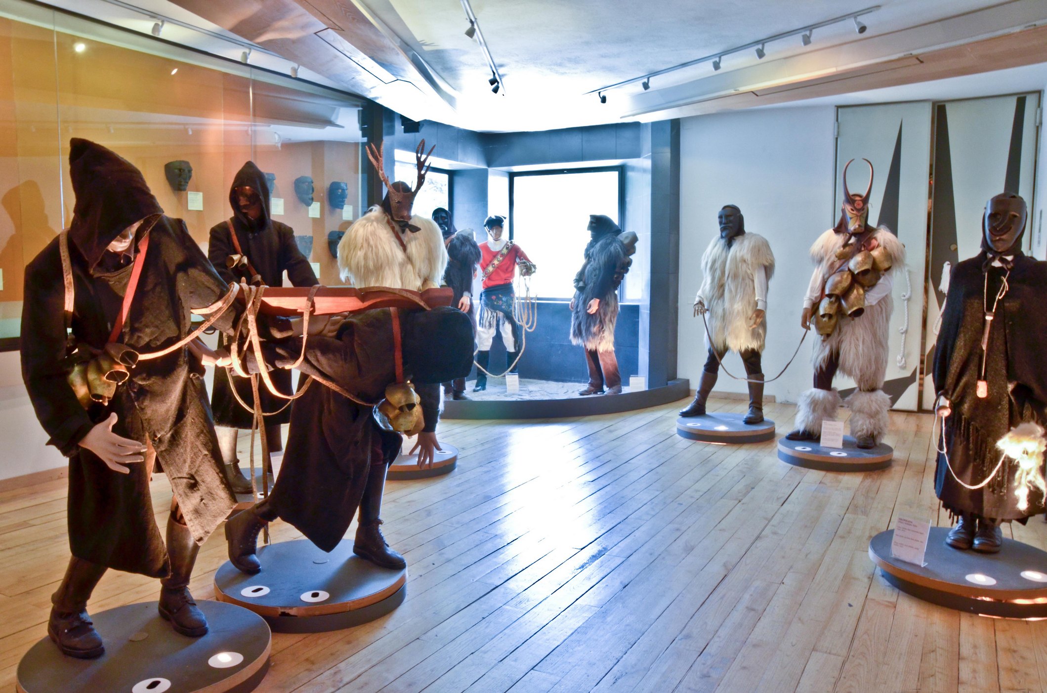
Museum of mediterranean masks
A point of contact between Sardinian traditions and other Mediterranean regions represented by the carnival masks and revealed in a unique place of culture, the only one of its kind. The Museum of Mediterranean Masks in Mamoiada, a village in the Nuoro area in the centre of the island, famous throughout the world for Mamuthones and Issohadores (traditional carnival masks), focuses on the common origin of the island's rituals, particularly those in the Barbagia area and those typical of other civilizations from more or less nearby lands, bathed by the same sea.
The museum focuses on the widespread use of wooden masks worn on the face, with animal and grotesque forms, as well as sheepskin and ram's skin, cowbells and other objects that make deafening sounds. In the rural and pastoral community, these costumes were thought to have influence over the fate of the agricultural year: despite their frightful appearance, their long-awaited visit was welcome and was seen as a chance to make them propitious, by offering them food and wine.
The museum will allow you to gain deeper knowledge of the local identity, starting with the local Mamuthones and Issohadores masks, and compare their affinity and similarity with artefacts from the different countries of the Mediterranean. Your visit will begin with images, texts and sounds, which recount interpretations offered regarding the origin of the Mamuthones. The pièce de resistance is the most ancient mask of Mamuthone, possibly dating back to the first few years of the nineteenth century. The Barbagia Carnival room will introduce you to a series of masks from central Sardinia: Boes, Merdules and Filonzana from Ottana and Thurpos from Orotelli. The third space, the Mediterranean room, is dedicated to carnivals in the Alps and the Iberian and Balkan peninsulas: you will discover affinities with the Sardinian ones.
Once your cultural experience in Mamoiada has ended with a visit to the house-museum, thanks to the museum guides, you can take trips to artisan workshops, nearby archaeological sites, to the Supramonte area and to the murals of Orgosolo.
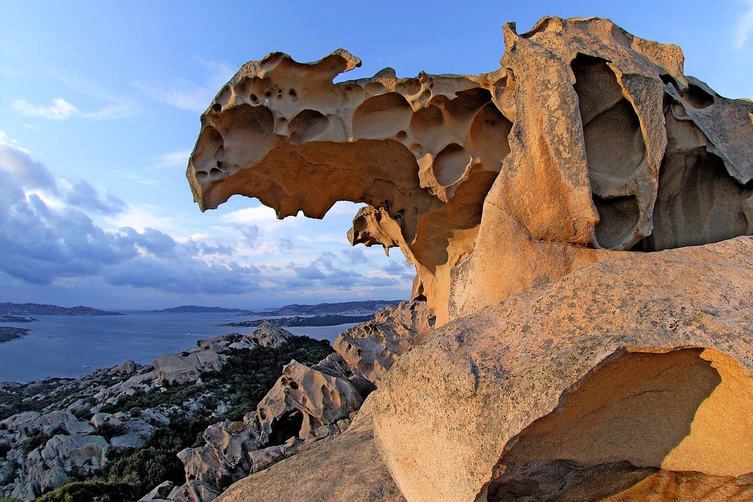
Roccia dell'orso
According to Victor Bérard, a writer and scholar of Homer, Capo d'Orso is the only place in the Mediterranean identifiable as being the 'land of the Laestrygonians', the giant cannibals who were the protagonists of the 10th book of the Odyssey and who inflicted serious defeats and forced Ulysses' desperate escape. The hero of the tale disembarked here, near the spring of Arcacia ('of the bear'), in search of food and water for the crew, which went onto become the local population's “feast". An aura of legend surrounds the cape before the La Maddalena Archipelago National Park, taking its name from a spectacular natural sculpture that extraordinarily resembles the shape of a bear seemingly nodding towards the sea. It is the Roccia dell’Orso ('Bear Rock'), a natural monument visited by thousands of hikers. It stands on a granite elevation, being over 120 metres in height, watching over the nearby village of Palau, a renowned tourist resort nestled in a cove in northern Gallura, close to the Costa Smeralda.
It is located just over five kilometres from the village, reached by a half-kilometre panoramic path - of which around ten minutes is slightly uphill - setting out from the fort of Capo d'Orso, one of the many 18th-century military fortifications of Palau, including the battalions of Monte Altura and Talmone. The promontory offers a view over the entire park of the archipelago, also being associated with the area surrounding nature's work of art, one of the most special rock formations in all of Italy. The granite rock, “carved” over millions of years by the atmospheric agents, is smoothed, seemingly dug out from the surface, with a characteristic yellow-pinkish hue.
The promontorium arcti ('bear promontory') has been known of since time immemorial. The shape of the bear was first noted by sailors in ancient times, with its name remaining unchanged since this time. The first historical attestation comes from the Greek geographer Ptolemy (2nd century AD) who, in addition to providing coordinates, tells of the fear that the Rock Bear induced in sailors due to being able to attract ships “like a great magnet". It is not by chance that the stretch of sea before it contains numerous cargo ship wrecks hailing from various periods in time, confirming the intense commercial traffic throughout this area. The rock has always been a point of reference, being clearly visible from the sea and mentioned in the Portolan Charts, for the sailors who happened to venture off the coasts of Gallura and Bocche di Bonifacio.
The territory of Capo d'Orso is also interesting from an archaeological point of view due to the presence of several tombs in tafoni and a lithic industry from the Neolithic age. The Nuraghe Luchìa and Li Mizzani and Sajacciu Tombs of Giants are the other most famous sites within the Palau territory, where life revolves around tourism and the harbour, from where you can set out on a hike through the park. Granite promontories and sandy stretches alternate from one end of the coast to the other, such as that of La Sciumara ('outlet' in the Gallurese language) and the picturesque coastline with the Nordic atmosphere of Porto Faro. Near the port are L'Isolotto, a cove of fine white sand, and Palau Vecchio, a beach bordered by a pine forest, from where the Trenino Verde ('Green Train') sets out towards the innermost areas of Gallura. Continuing to the west, facing the island of Santo Stefano, the village of Porto Rafael unveils an exclusive and luxurious side of the area. Its most famous bay is Cala Inglese, known as the “Porto Rafael pool”. Extending nearby is the white stretch of Costa Serena. Then there is the indomitable beauty of Punta Sardegna and the exotic features of Cala Trana, nestled amongst the dunes, granite rocks, junipers and lentisks, being characterised by pinkish sand. To be found in the direction of Santa Teresa Gallura is the paradise of Isuledda or Isola dei Gabbiani. In fact, this is a peninsula joined to the mainland by an isthmus surrounded by the turquoise sea. Fanning out within the 'sandy stretch' are the Arenaria beach on one side and on the other, Porto Pollo - a dazzling beach ever caressed by the wind and the Sardinian town famed for funboarding, windsurfing and kitesurfing. Extending before the surfers' paradise is the Isolotto Cavalli and, in the distance, the beautiful La Maddalena islands of Spargi and Budelli.
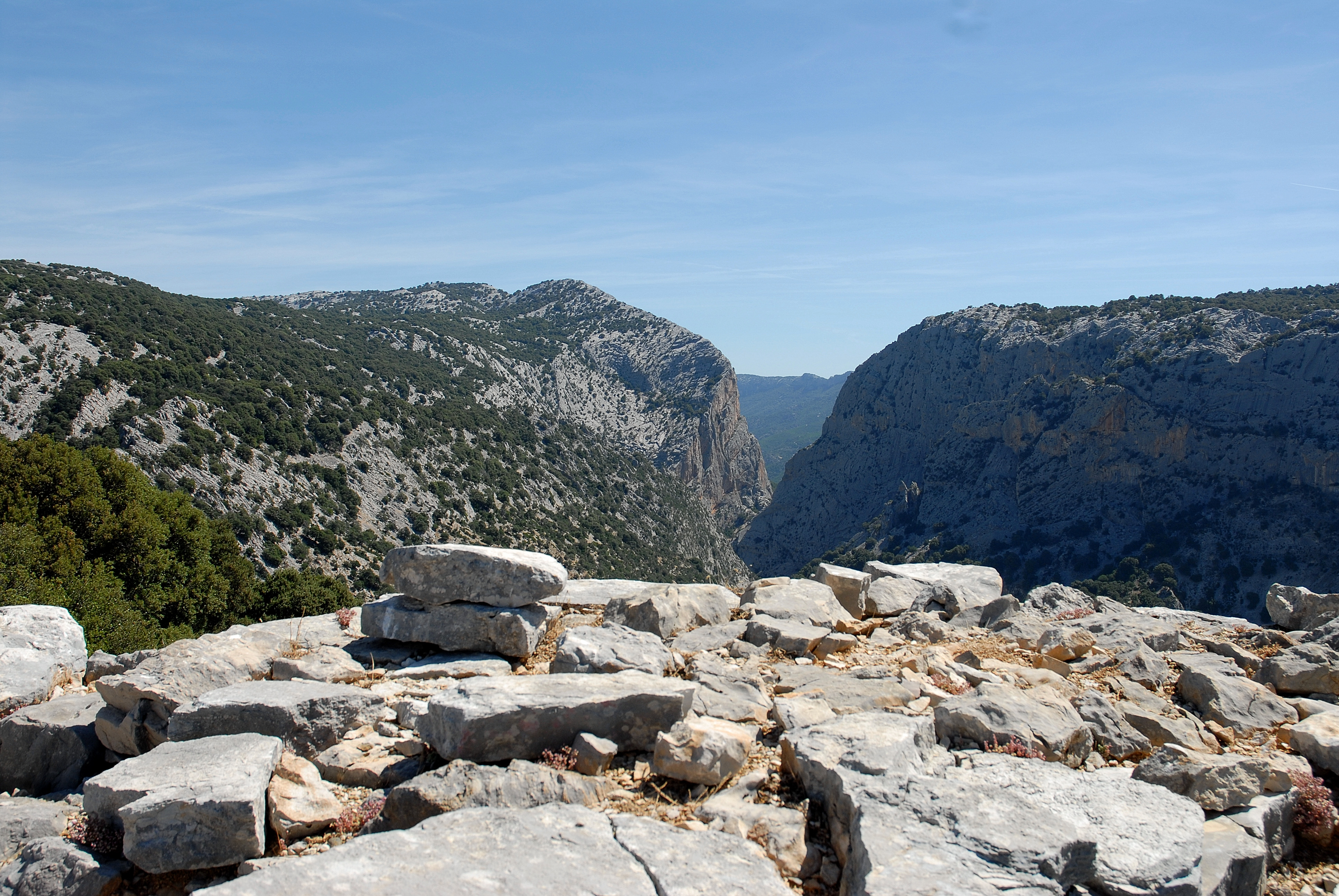
Gorropu
It is the most spectacular canyon in Europe and it is also one of the deepest: while driving down the eastern coast of Sardinia, you really must stop to visit it. Gorropu (or Gorroppu) is a gorge, created from erosion and located in the Supramonte area, between the territories of Orgosolo (Nuoro) and Urzulei (Ogliastra). It has been shaped over time by the force of the Rio Flumineddu rivulet that flows along its bed, at a depth of 500 metres. The width of the gorge varies from a few dozen metres to just four meters. You can reach it, departing from the Gorropu base camp, on the promontory of Su Cungiadeddu (altitude of 830 metres): in five minutes, you will be at the Genna Sìlana pass. From here, you can admire a unique landscape: from the Supramonte areas of Urzulei, Orgosolo, Oliena and Dorgali to Gennargentu and, on clear days, as far as Baronìa. It is the wildest territory on the Island: if you want to tackle its trails, place your trust in local hiking companies and equip yourself with technical equipment. The landscape is marked with long còdule - limestone gullies that sometimes stretch to the sea - narrow gorges and deep sinkholes, caves and ponors, cliff faces and peaks of over a thousand metres high. The area is covered with spectacular juniper trees, thousand-year-old yew trees, holm oak forests and Mediterranean species (among which oleanders and broom), is the habitat of typical Sardinian wildlife, like the golden eagle and the mouflon. There are also prehistoric remains: Nuragic villages and towers and Tombs of Giants, which blend into the environment and are positioned to watch over the territory.
You can reach the gorge along the Sedda ar Baccas-Gorroputrekking trail 'for experts', which is twelve kilometres long (in approximately three hours). Alternatively, you can leave Dorgali, crossing the valley of Oddoene (by car) until you reach the s'Abba Arvabridge and, from here, you can continue on foot for two hours, along a stretch of the Flumineddu river and the southeastern side of Mount Oddeu. These territories were the place of Sardinian resistance for centuries: the rulers had a difficult time here, as this was the area most hostile to Roman militia (Cicero's montes insani). The unusual nature of the place has generated legends: one tells us that, from the narrowest point of the gorge, where the vertical rock faces are over 450 metres high, you could see the stars in broad daylight. Or, it is said that the magical flowers of the 'male fern' bloom by night: only the bravest and greatest experts can pick them.