

Marina di San Pietro
Nestled between the beautiful Cala di Monte Turno to the north and Cala Sinzias to the south, it has featured in prestigious magazines as being one of the most beautiful sections of the Mediterranean. The San Pietro marina is a broad and very extensive beach that contributes to the spectacular coastline of Castiadas, a jewel and tourist resort in Sarrabus, to the south-east of the island. The expanse of more than three kilometres of fine, golden sand borders a clear sea with iridescent shades ranging from emerald green to turquoise. Close to the shore, the seabed is sandy, immediately becoming rather deep. Being wider, it is perfect for snorkelling and spectacular scuba diving in search of groupers or colonies of soft corals thanks to the diving centres in the area. Much of the coastline is unencumbered, with some spaces being occupied by resorts and restaurants. You can rent beach umbrellas and bathing equipment and avail of all the services at your disposal. Behind is a lush naturalistic oasis of Mediterranean scrub. On the promontory that borders the beach stands the Nuraghe Gibe Truttiri.
Sea and tropical beaches, natural oases and quality food products. These are the characteristics of Castiadas, a municipality that occupies a vast and rich territory, inhabited since the pre-Nuragic period and frequented until Roman times, today consisting of villages. Its fertile fields produce wonderful vegetables and citrus fruits, whilst its 13 kilometres of coast represent one of the most beautiful stretches of Sardinia, a succession of white sand and dazzling colours. To the south of San Pietro is Cala Sinzias, its natural continuation, being a kilometre of soft, white sand with a clear seabed and azure waters. It is backdropped by thick vegetation of lentisk, pine and eucalyptus trees. Further south, on the border with the marine area of Capo Carbonara-Villasimius, you will find an absolutely precious jewel, being Cala Pira, a stretch of paradise consisting of 400 metres of soft dunes surrounded by granite and perfumed by centuries-old junipers and Mediterranean scrub. Beyond the promontory north of San Pietro, lies the beautiful cove of Monte Turno, chosen in 2018 by the experts of the holiday web portal of Skyscanner as Italy’s beach of the year. Beyond this begins the stretch of Costa Rei, extending around two kilometres and belonging to the territory of Castiadas, from the inlet of Sant’Elmo to the intimate cove of Cannisoni, from the long beach of Santa Giusta, framed by smooth cliffs, up to the beautiful ‘Scoglio di Peppino’, bordering Muravera. Backdropping the coast is the mountainous profile of the Oasi dei Sette Fratelli, a natural park ideal for taking relaxing walks, dotted with archaeological sites.

Sant'Anna - Cagliari
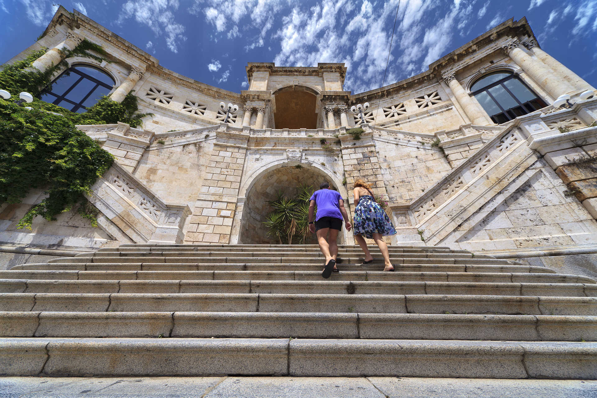
Its domes are easy to recognise from numerous panoramic points in Cagliari, its steps are set between the narrow streets of the Stampace district in Cagliari and it is one of the most spectacular sights in the city centre. Today, the Church of Sant’Anna presents itself in recent Baroque style, but its origins probably date back to the 13th century, closely linked to the history of the city. The Judicate capital of Santa Igia was wiped out around the middle of the 13th century by the Pisans, who established the centre of their dominion in the Castello district, which was especially fortified. The population settled at the foot of the fortifications, giving rise to Stampace, and elected Sant’Anna as their patron saint, building a small church in her honour, probably Romanesque style. The medieval sanctuary was demolished in 1785 and the foundation stone of the new church was laid based on a design attributed to the Piedmontese architect Giuseppe Viana. Construction proceeded very slowly and the inauguration took place in 1818, when the bell towers and main altar were still missing. The interiors were completed at the beginning of the 20th century and the second bell tower in 1938. A few years later, the bombings during the Second World War caused collapses and serious damage to the furnishings. The church didn’t open again for worship until after the war. The various ups and downs gave rise to a sarcastic saying used by the people of Cagliari: sa fabbrica de Sant’Anna, which, in the city, means something interminable.
There are three flights of steps before the building. At the end of the steps, you will find yourself in front of the Piedmontese Baroque-style façade, with a concave central part. The façade is divided into two orders: in the lower one, there are two pairs of columns with Ionic capitals framing a door, above which there is a split tympanum and a rose window; the upper one is decorated with pilasters. The two impressive bell towers emerge from a position set back from the façade. The interior has a single nave with a transept, covered by three domes. There are four chapels on each side, preceded by open arches on a cornice decorated with mouldings, on top of which there are the domes. In the presbytery area you will notice eight tribunes overlooking the altar, while among the furnishing elements that stand out, there is a marble statue of the Crocefisso dei Muratori, donated by King Carlo Felice, and a sixteenth-century wooden crucifix.
There are two other famous historic buildings of worship in Stampace, a stone’s throw from Sant’Anna, standing over underground cavities: the seventeenth-century Church of Santa Restituta, with a crypt that was a place of Phoenician and early Christian worship, then a Roman cistern, followed by a quarry and lastly a shelter used during the bombings; the other is the Church of Sant'Efisio, built on the cave considered the place in which the martyr was imprisoned, starting point of the biggest religious festival in the whole of Sardinia.
San Giacomo - Cagliari
It is the parish church in the historical district of Villanova, at the foot of the Castle, and one of the four most ancient parishes in Cagliari. The church of San Giacomo is located in the square of the same name, at the end of two of the town’s famous shopping streets, Via Garibaldi and Via Sulis, and flanked by the façades of the oratories of the Anime (Souls) and of the Santissimo Crocifisso (Holy Crucifix). The first mention of it is in the ordinances of the Councilors of the Castle (1346). It was probably built around that date. A century later it was flanked by the square bell tower, thirty metres high, as is written on a plaque placed at its base. The temple, one of the first examples of Gothic-Catalan architecture in Sardinia, was renovated between the 18th and 19th centuries. In 1630, its rank was elevated to collegiate church. It was consecrated in 1781. The church of San Giacomo, in the capital, acted as a model for various churches in the central-southern part of the Island, between the 15th and 17th centuries, among which the parish churches of Assemini, Atzara, Sestu and Settimo San Pietro.
The Gothic-Catalan façade was replaced during modifications, which took place in the 19th century, by the current neoclassical purist forms, work of the famous architect Gaetano Cima: it is divided horizontally by springcourse cornices and vertically by four sturdy columns with smooth shafts and Corinthian capitals, supporting a triangular tympanum. At the centre, there is a wooden entrance door with lunettes. The interior, which underwent alterations in the eighteenth-century, has maintained its original Gothic layout with one nave and a barrel-vaulted ceiling supported by parastades. You can admire five chapels on each side, almost all with ribbed cross vaults, except for two that have a dome ceiling. On the left side, the first chapel contains an exquisite 15th-century terracotta Lamentation, while the style of the third chapel, dedicated to the Crucifix, is Baroque, like the chapel of the Sacred Heart, second on the right. On the multi-coloured marble altar, which is the work of Giovanni Battista (18th century), you will notice a group of wooden sculptures, also created in the 15th century, made up of a crucifix and statues of the devout women under the cross. The area of the presbytery, which is raised and enclosed by a marble balustrade, consists of a typical Catalan capilla mayor, with a beautiful star-shaped vault and hanging gems. The church also contains an exquisite organ dating back to 1769.
Solarussa
It is set in north Campidano plain, in the lower valley of the Tirso river, in one of the island’s most fertile areas cultivated for grapes, olives, artichokes, tomatoes, watermelons and melons. Solarussa is a farming town of 2500 inhabitants just over ten kilometres from Oristano, where the Peace Treaty between Eleonora of Arborea and John I of Aragon was signed in 1388. Its Latin name, solum russus, refers to the red-coloured earth in the area. In the 20th century, local industry included the oil-products industry, which produced olive-pomace oil, and an agricultural processing plant, a first of its kind on the island. Today, the town is known for its wine: in Bennaxi, Solarussa’s prolific countryside, the land is green with vernaccia vineyards. The sumptuous wine made from these grapes is the focus of a festival where it is paired with local dishes.
Even carnival follows this theme: called Su Bingiatteri, the ‘vine grower’. Until mid-20th century, bricks and roof tiles were being produced in Bangius and Cu ‘e Forru. They were then used to build the rural homes in the town’s city centre. These homes, some of which are embellished with murals, can be seen to this day. Casa Sanna, the site of cultural events, with its wrought iron balconies and large doorway is one splendid example. It is located in the upper section of the town, next to the Church of Madonna delle Grazie. Once a pilgrimage destination, it is now the site of a late May festival. The façade of this charming church is characterized by an arcade with three orders of arches and by two similar bell towers. The impressive Parish of San Pietro Apostolo, consecrated in 1835, houses 18th century paintings by Pietro Angeletti. Adjacent, stands the Church of Anime. Constructed in 1749, it contains precious furnishings: a polychrome marble altar and a wooden pulpit. On a small hill in the town’s outskirts, stands the Church of San Gregorio Magno, built between 12th and 13th centuries over the ruins of an older building using trachyte and basalt ashlars in minor Romanesque style. The celebration held in its patron saint’s honour in mid-October is the town’s most anticipated. Next to the church, the ruins of a well, Putz’e Angius, and possible thermal baths building, both Roman, can be seen.
In Solarussa, the Romans set up a rest stop along Via Maxima, which links Tharros and Forum Traiani. Coins, the ruins of domus and pottery found at Cuccuru Madau are additional evidence of Roman presence. Of the many Nuragic settlements, the most significant is the Complex of Pidighi, consisting of the very similar nuraghes of Pidighi and Muru Acca and their respective settlements as well as nearby water sources. Both consist of a main tower, an open courtyard and a secondary tower. At the Mitza Pidighi Spring, already known in Pre-Nuragic times, as seen from obsidian and pottery findings dated to 4000 BC, water is still flowing from a small cubicle around which an enclosure, possibly containing an altar, was constructed in 1000 BC.

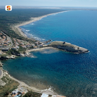
Porto Pino
Little coves with pink sand and crystalline waters, long, white, deserted beaches, rocks with breath-taking seabed, ponds inhabited by flamingos, and, inside, groves, vineyards, grottos, culture and culinary traditions. This is Porto Pino, in the territory of Sant’Anna Arresi, made even more beautiful, to the east, by the homonymous promontory covered in oaks, ancient juniper trees and very rare Aleppo pines – according to legend, the wood favoured by the Phoenicians to build their ships. The other side is dominated by Mediterranean scrub.
The Porto Pino beach is about four kilometres long, divided in two parts by an old sea outlet for the ponds. The “first beach”, not far from the parking area, features greyish sand while the “second”, nestled between lagoon and pine grove, has white sand and meets Is Arenas Biancas, tall, white dunes in the territory of Teulada – also called Le Dune, another awe-inducing expanse, one kilometre long, of soft sandy hills that reach up to 3 metres of height.
The Porto Pino coast, characterised by a shallow seabed that makes it perfect for children, is accessible to disabled people and features plenty of parking space (for campers as well) and all necessary services: rental of beach equipment, hotels and camping sites, cafés and restaurants. It is also the perfect destination for surfers all year round and much beloved by divers and fishermen. A canal crosses the strip of sand and the pine grove in the part of the beach belonging to Sant’Anna Arresi, and connects sea and the lagoon area, consisting of the Maestrale, Porto Pino, Corvo, Is Brebeis and Foxi lagoons.
Nearby, always in the territory of the Sulcis commune, there is also the beautiful Spiaggia dei Francesi (Frenchmen’s Beach), in Porto Pinetto, a half-moon of fine white sand with shells and coral fragments that dives into the sea in shallow waters that change from emerald green to turquoise and azure. After the beach, dive into the culture of Sant’Anna Arresi, a lovely little town that features Nuraghe, called Arresi, right in the centre of the town between the two churches, the old and the new, dedicated to Sant’Anna – the town is named after the saint.
Spiaggia Stella
Positioned at the entrance to the town of S'Archittu, the beach is protected to the south by a large cliff 'La Balena' (the whale) and the sandy sea bed which allows a number of rocks to poke through. The beach of Stella is found in the locality of S'Archittu in the municipal area of Cuglieri. The beach has averagely coarse, light-coloured, greyish sand along with small pebbles and smooth rocks. The turquoise colours of its sea make this a much love spot for the numerous tourists that flock here.
Torre degli Ulivi
The beach has a stony base, with rock formations and small areas of coarse sand mixed in with various grain gravel. Located along the coast in a particularly important stretch, it is home to an ancient look out tower that gives the area its name: Torre degli Ulivi
Rena di Levante and Rena di Ponente
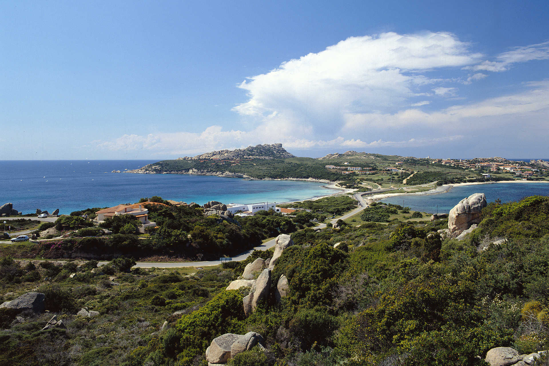
In the territory of Santa Teresa Gallura, four kilometres from the residential area, along the isthmus that joins the peninsula-promontory of Capo Testa to the mainland, there are two beautiful beaches: to the west there is Rena di Ponente (or La Taltana) and, to the east there is Rena di Levante. Their position makes it possible to enjoy the calm sea, choosing one or the other, based on the direction of the wind. Striking granite cliffs that the wind and sea have modelled into strange and original shapes, making the scenario even more captivating,are coloured by the green Mediterranean vegetation. The purity of this stretch of sea is amazing, earning it the Blue Flag award, and it is particularly suitable for children, for relaxing walks in the water and interesting diving.
The beach of Rena di Ponente has soft white sand and is washed by the colours of the sea, ranging from turquoise to blue and emerald green. Rena di Levante has a low cliff that slopes down to the beautiful Capicciolu(or beach of Zia Colomba), with its golden sand and transparent, shallow waters. This was the site of the Roman colony of Tibula and traces of its roads are still visible. It was the point of departure for ships laden with granite, used to adorn the palaces in Rome. Close to the Reno di Ponente beach, you will see granite rocks that the wind and water have modelled into cylinder shapes that resemble Roman columns.
On the western side of the cape, there is another symbol of the Santa Teresa coast: Cala Grande-Valle della Luna: impressive granite rocks, shaped over thousands of years by the force of the weather, take on an unusual shade of white when lit up by the moonlight. Here, you will find secluded little coves with crystal clear waters. Before reaching the peninsula, leaving the residential area of Santa Teresa, the little rocky coves of Santa Reparata are also worth visiting. Not far from the historical centre of this Gallura locality, you can enjoy the dazzling colours of Rena Bianca, a city beach of immense beauty, watched over from above by theSpanish tower of Longosardo. To the east of the village there are numerous other gems to be seen: Cala Sanbuco, La Marmorata and, in moving towards Palau, Valle dell'Erica, Porto Liscia-Sciumara and Conca Verde.

Abbasanta
The houses, made of dark volcanic stone, in the historical centre of the village, extend across the basalt plateau of the same name in the historical territory, full of woods, of Barigadu. Abbasanta is a village with two thousand 700 inhabitants and is a slow food presidium for casizolu (typical local cow's milk cheese). Abbasanta has been famous for its central position in the heart of Sardinia since Antiquity and it is no coincidence that today it is at the centre of the main thoroughfare, trunk road 131. In the Roman era, it was known as Ad Medias Acquas. The subsequent Aba Sancta (holy water) was mentioned for the first time in the 12th century in the rationes decimarum (payment of ecclesiastical tithes). There was a human presence in the area long before the Romans arrived and dates back to the Neolithic period, as is demonstrated by the S'Angrone domen. The sacred well of Calegastea, the tomb of Giants of Sos Ozzastros and numerous Nuragic complexes date back to the Bronze Age. The most famous is nuraghe Losa, located three kilometres from the village. It is made of 'regular' basalt blocks, it has a complex structure and is the result of various phases of building between the 15th and 12th centuries BC: a keep (central tower) 'protected' by a trilobed bastion, with its highest tower reaching 13 metres, also surrounded by a defence wall. It was less frequented during the Iron Age and was later used for funerary purposes. Another important nuraghe is the single-tower Zuras, dating back to between the 14th and 12th centuries BC, worthy of note for the precision used in building it. From its upper terrace, you can see other sites in the area, among which the poly-lobed nuraghe Aiga, around which you will notice the remains of a village dating back to the middle of the 2nd millennium BC. Not far from Abbasanta, in the territory of Paulilatino, another fundamental Nuragic site stands out: the evocative Sanctuary of Santa Cristina with the surrounding village.
The village centre is located around the parish church of Santa Caterina d'Alessandria, which was first built in Catalan-Gothic style in the sixteenth century on the ruins of a nuraghe. It was completely renovated at the end of the nineteenth century, inspired by Renaissance forms: it has a Latin cross layout with a single nave, on which three chapels open up on each side. Other village churches are Sant'Amada (or Dorotea), built in Gothic-Aragonese style in the 16th century, and the seventeenth century Santa Maria delle Grazie. A walk in the Parco di Sant'Agostino park is a must, where you will find a little village of muristenes - lodgings that accommodate worshippers during the celebrations in honour of the saint at the end of August - around a rural sanctuary of Bizantine origin, with centuries-old cork oaks and downy oaks. Other examples of spectacular nature are the Bonorchis spring, near the locality of Tanca Regia, where there is a horse breeding centre and, nearby, prehistoric funerary areas like Domus de Janas, that of Mesu Enas and the tomb of Giants Su Pranu.
Cala d'Ostia
Cala d’Ostia is found in the locality of Santa Margherita in the municipal area of Pula. The beach is made up of a base of light coloured sand mixed with gravel, and has rocks and stones of various sizes, with water that becomes quite deep. It is a small bay characterised by splendid tonalities of the sea and by rich plant life: posidonia, eucalyptuses and wild pines, all watched over by a nineteenth-century lookout tower built near the ruins of another built in the Spanish epoch. The beach is found in the vicinity of the archaeological zone of Nora, a town founded by the Phoenicians between the 9th and 8th century B.C., the oldest - it seems - in Sardinia. The archaeological area is found at the foot of the promontory of Capo di Pula. many treasures remain visible in the site. the mosaics, the town lay-out with thermal baths, temples and a theatre of the Roman era.