


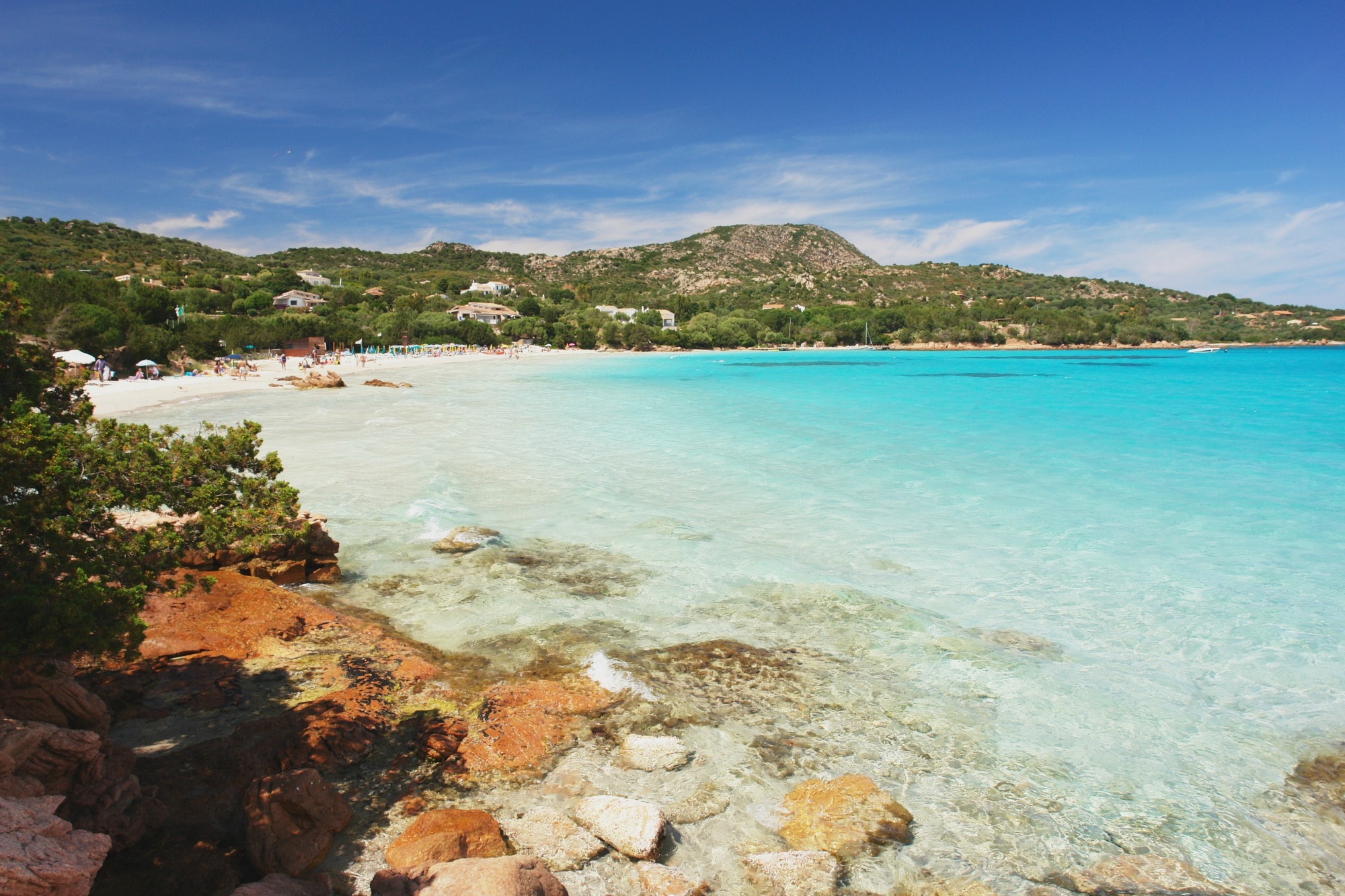
Calamosca
Set in a splendid bay overlooked and sheltered, almost protected, by two impressive promontories: to the east is Capo Sant'Elia, dominated by an ancient lighthouse, to the west is the fascinating Sella del Diavolo (Devil's Saddle), named for its peculiar shape which legend has it was the place where Lucifer landed when he was thrown out of heaven. Calamosca beach, only four kilometres from the centre of Cagliari, is located along the long, wide coastline of Poetto. Its transparent waters gleam with emerald and azure tones, while the sandy beach and smooth pebbles gently slopes to the sea, making it perfect for children and particularly popular with underwater fishing and diving enthusiasts. There is plenty of parking space, a bar-kiosque and beach equipment to hire.
A small path leads from the beach up to a panoramic viewpoint over the Golfo degli Angeli. You'll need to climb up to the promontory to the foot of the Calamosca watchtower, built by the Spanish in the 17th century. We recommend taking hiking shoes and equipment and following the path to the left of the cliffs, towards the Sella del Diavolo: along the way, you can admire numerous small coves before arriving in another miniature paradise with a rocky seabed, Cala Fighera. The path will let you explore all around the "Sella" and the fortifications built on the hills: an amazing experience after sunset, together with a specialised guide.
In Calamosca bay you'll find open-air bars and nightclubs, perfect for summer fun, as well as restaurants where you can try speciality seafood. The vicinity to Cagliari's historical centre with its dozens of cultural attractions and monuments will make you appreciate this wonderful cove even more. What's more, don't miss the nightlife at the kiosques in Poetto, one of Europe's largest town beaches, and only a short walk away.
Pompu
Extending within the Riu Laccus valley, brimming with holm oaks, downy oaks and cork oaks, it lies amidst fertile hills, with the most prominent being Mount Futtu. Pompu is a village of the upper Marmilla region with less than 300 inhabitants. Until 1970, it was a part of Masullas, formed by low stone houses with portals and courtyards. The predominant agricultural activity, with grain crops, vineyards and olive groves, is flanked by crafts, especially that of weaving and the production of bread (civrasciu, coccoi, lada, pani pintau) and sweets (amaretti, gueffus, pabassinos, pardulas). The name derives from the Latin pompa or, ‘procession’. In ancient times, a pilgrimage to the Santa Maria di Monserrato sanctuary was customary prior to the birth of Pompu. Legend goes that, around it, a community of the faithful was established, custodians of the church and those who arranged the pompa, from which arose the first residential nucleus. Hence the name Pompesi and the name of the village. Today, local festivities take place in early September. A statue of the Madonna is accompanied from the little church in the heart of the village, where the parish church of San Sebastiano stands, housing the 18th-century statues of the patron, celebrated on 20th January with a large bonfire and Saint George fighting a dragon on horseback.
An abundance of water, the richness of the soil and proximity to the current Monte Arci park have facilitated the occupation of the territory from Neolithic times. On the border with Morgongiori is the Prabanta complex (3500-1800 BC), with an imposing 3.5-metre menhir, a fertility symbol, and two Domus de Janas, used for funerary rites, respectively called Su Furconi, Sa Sala and Su Forru de Luxia Arrabiosa. From the pre-Nuragic there are seven stations and three workshops for processing obsidian, prehistoric ‘black gold’, hailing from the rich deposits of Mount Arci, worked and traded throughout the Mediterranean. Other rare mineral such as agate, carnelian and amethyst are extracted from the massif. Of note are the remnants from the Bronze Age, the Nuraghe Su Sensu and, above all, at 1.5 kilometres from the town, the Nuraghe Santu Miali, a splendid complex structure consisting of a central tower and a quadrilobate bastion with an internal courtyard. Made with squared sand stone boulders, it dominates the territory, surrounded by a village of circular huts, having been inhabited until the early Middle Ages. The findings date back to ancient rites: bones, coins and oil lamps testify to the use of the courtyard in late-antiquity rituals. The oil lamps, in particular, refer to the divinities - perhaps Ceres - of Romanised Sardinians, decorated with a ‘cross and P’ suggesting the presence of Christian communities, whilst those with the Menorah refer to Jewish rituals. The tomb Su Laccu de su Meli and remains of once-inhabited areas testify to the Roman domination.
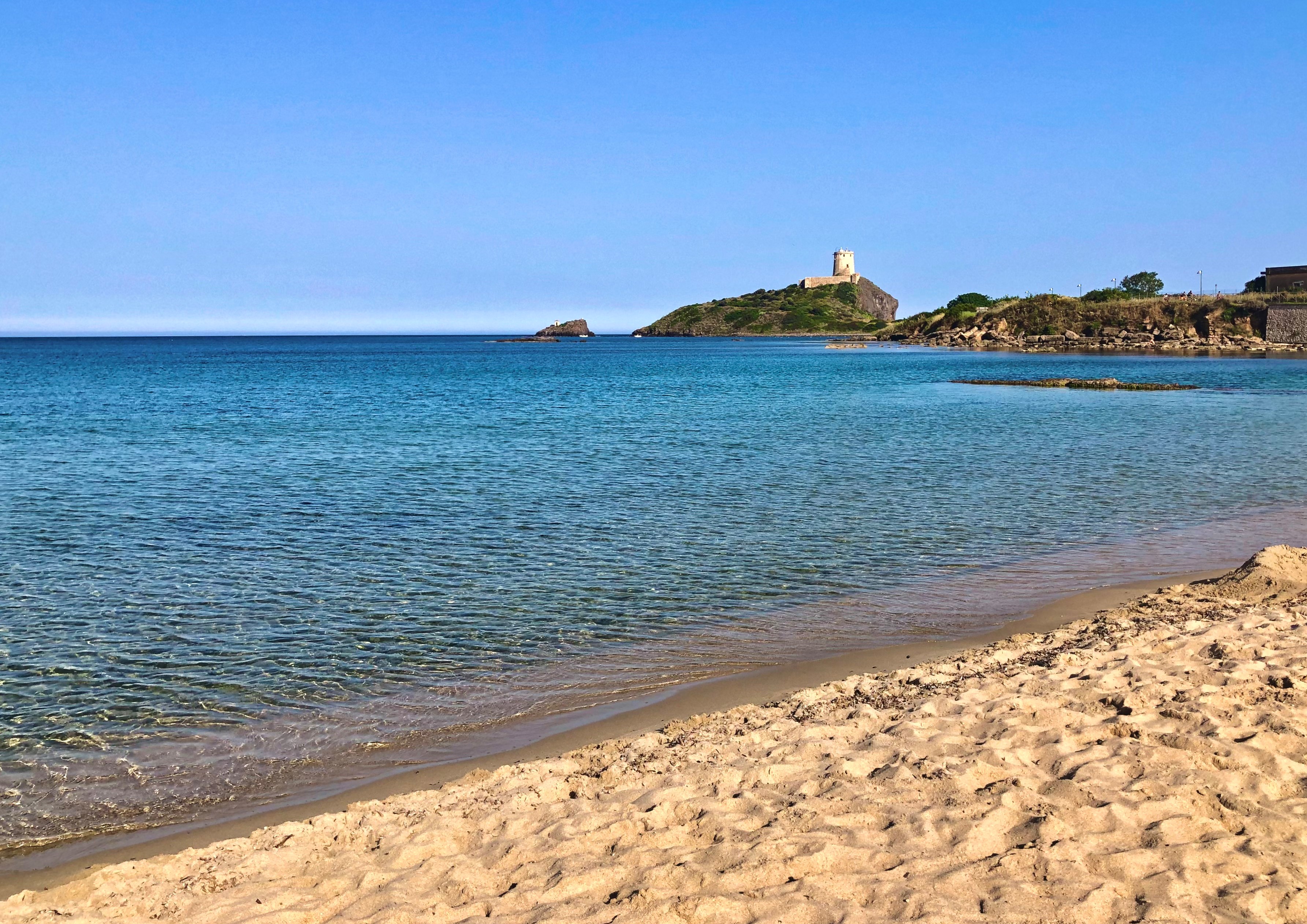
Nora
The large-grain white sand, rocks full of natural life, overlooking tower and ruins of ancient civilisations make this a unique, unmistakable destination. The beach at Nora is one of the most famous in Pula, thanks to the backdrop of the nearby Roman ruins. The bay is enclosed by cliffs and the promontory, with the splendid Coltellazzo tower, and is therefore sheltered from the wind. When the north wind blows strongly, the beach is perfect for enjoying the sun and swimming in the clear, shallow sea, ideal for children. The shimmering tones of blue sea invite you to take a swim, go diving or underwater fishing. The beach has access for persons with disabilities and is convenient thanks to its large car park, services and refreshment points.
It has considerable historical value, located near the Nora archaeological park. The old town was founded by the Phoenicians between the 9th and 8th century BC. However, the traces of the Phoenicians and Punics have been mostly covered over by the Romans. The area is situated at the foot of Capo Pula, the old port, separated from the mainland by an isthmus, offering safe refuge from any wind. The church of Sant'Efisio is also built on the beach, and was traditionally known as the place of the saint's martyrdom. On 3 May each year, a procession for the saint passes by here, in one of the most intense moments of the four days of the Festa di Sant'Efisio. Behind the bay, don't miss seeing the sun go down over the laguna. Take a stroll through the tree-lined streets, and you'll get to the squares of Pula and its nightlife.
Nearby, there are more attractions along the coast: to the east of Nora there is su Guventeddu beach, particularly popular with kite and wind surfers. To the west lie nearly ten kilometres of the splendid Santa Margherita coves, with stretches of fine sand and clear water, broken by small promontories: Cala Marina, Cala Bernardini and other smaller and more isolated coves, as well as the beaches of the numerous resorts that overlook this paradisiacal seaside.

Cala Ghjlgolu - della Tartaruga
This is where nature sculpts the granite rock. Cala Ghjlgolu (or Girgolu) is found in thelocality of Vaccilleddi, at the base of the Monte Petrosu promontory, in the territory of Loiri Porto San Paolo. Its turquoise sea and white sand make it shine and it is known above all for the rock of La Tartaruga - from which it gets its ‘second’ name - an attraction for visitors, especially younger visitors. It is one of the most photographed rocks not only in Gallura but in the whole of Sardinia and is the result of thousands of years of erosion caused by the weather. Other rocks also make the cove stand out: these are called ‘tafonate’ and are eroded by the quartz crystals from the granite that, when crumbled, rotate wildly as an effect of the wind.
The beach is a wonderful source of continuous surprises: ochre-coloured sand mixed with smooth pebbles. The waters are shallow and the seabed is sandy, a perfect place for taking a nice, safe, peaceful dip and it is also ideal for children. You will find all the services you need: parking, facilities for the disabled, campsite, place for dining/refreshments, beach umbrella, sunbed, canoe, pedalo and dinghy rentals. Behind Cala Ghjlgolu, the landscape is enriched by a small pond, which is the habitat of several bird species.
Along the nearby coast, you will find a series of charming little coves, connected to each other and surrounded by Mediterranean scrub and light granite rock. Little trails make it possible to move from one to the other, in the setting of themarine area of Capo Coda Cavallo and the island of Tavolara, rising up like a mountain over the brightly-coloured sea.
Nearby, a visit to the beaches of San Teodoro is a must: the endless, narrow strip of golden sandof the Cinta, the white shoreline and the tropical waters of Cala Brandinchi and the nearbyLu Impostu or the splendid S'Isuledda and the beach ofAldia Bianca.
Elini
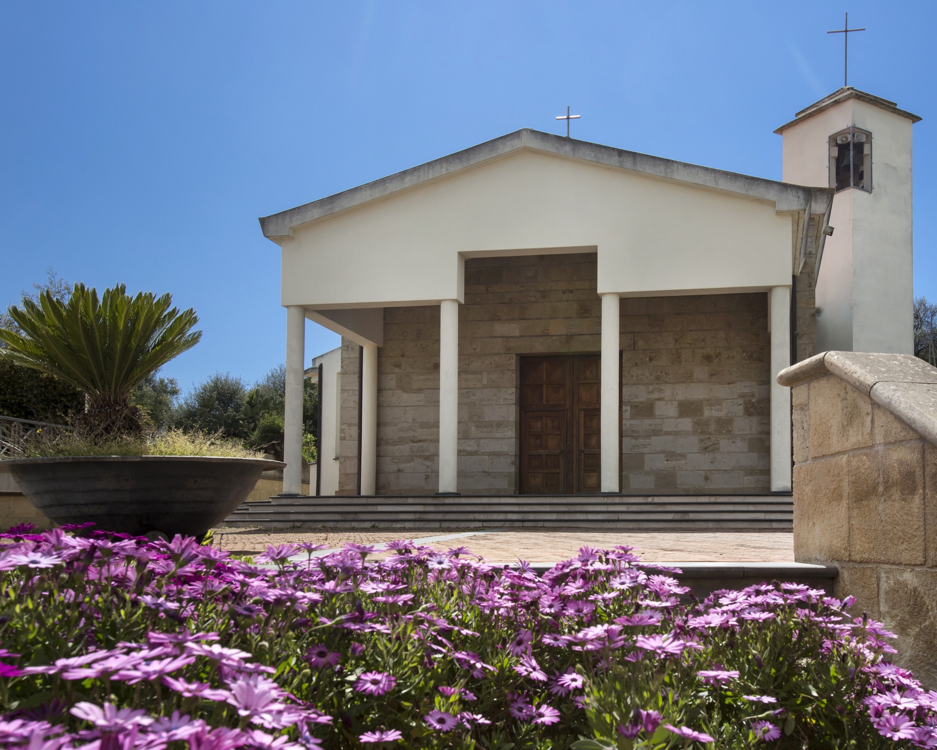
Halfway along the road, between the blue Ogliastra sea and the rugged Gennargentu mountains, the smallest village in the Ogliastra region is perched at a height of almost 500 metres. Elini, which has about 600 inhabitants, extends along a valley covered in centuries-old olive trees, protected from the predominant northwesterly Mistral wind in these lands by the tall mountains. Its territory is filled with numerous springs, which make the area very fertile: olive trees, vineyards and orchards grow here, and there are also holm oaks and downy oaks. The most evocative means of transport to reach this place is the train: accompanied by the soft sound of the wheels on the tracks, you will travel through enchanted landscapes, between limestone 'buttes' surrounded by the lush nature. Once you reach the centre of the village, you will descend into the old station, built in the nineteenth century from granite blocks. In the old town centre the parish church of San Gavino Martire is worth visiting. It was built in the 20th century on sixteenth-century foundations. In the upper part of the village, you can enjoy a spectacular landscape and you can walk between holm oaks and continuous springs: the Parco Carmine park is located here and is a must during your visit. Inside it, you will also find the ruins of two Nuraghi and, above all, you can admire the beautiful sanctuary of Madonna del Monte Carmelo, dating back to the 17th century. According to the canon Flavio Cocco, the origin of the little village is linked to the park. Here, in Antiquity, a Roman military garrison apparently installed itself here. The Elini people venerate the warrior saint Gavino, celebrated solemnly every year on 18 May, and this points to the military origin of the place. The most heartfelt festivity, however, is in July, with celebrations and processions taking place for three days.
Marina di Cardedu
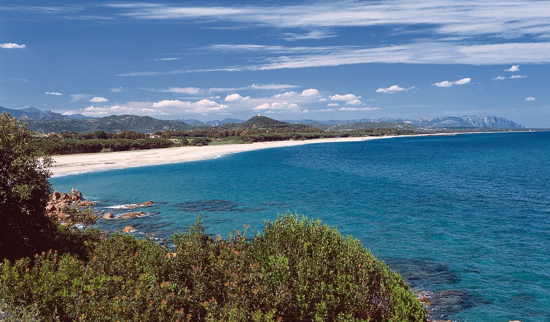
Eight kilometres of beaches, one of the longest on the Island, where stretches of light sand alternate with brighter-coloured pebbly sections. The Marina di Cardedu is a very long coastline in southern Ogliastra, protected by an expanse of eucalyptus trees behind it, overlooking the clear sea reflecting shades of blue and emerald green. Thanks to its considerable size, the coast is never too crowded, not even in high season, while its position means is exposed to the sirocco winds, making it a destination for surfers. The sea quickly becomes deeper and is ideal for diving and snorkelling. The surrounding landscape is wild and captivating, with the hills of Monte Ferru standing out in the background, covered with Mediterranean scrub and sloping towards the sea with spectacular cliffs.
To the north of the Marina di Cardedu lies the beach of Foddini with sand that has golden reflections and an unusual lake next to it. Even further north, without interruption, the coast of Barisardo begins. To the south, beyond the main beach of the marina, is Museddu, where the sand is just as light but a little coarser. The blue reflections of the sea and the greenery that surrounds the coast create an enchanting colour effect. The wide beach allows for relaxing walks and horse riding. The deep waters are frequented by underwater fishing enthusiasts. Continuing further south lies the beach of Perd’e Pera: here, red porphyry rocks start to decorate the landscape, the sand is white and fine and the sea offers shades of blue and emerald green. Behind it, the eucalyptus pine forest provides shelter during the hottest hours. On the beach, you will find all the services you need, bathing establishments, refreshment areas and small boat hire.
The reddish cliffs become clearly dominant on the border of the Marina di Gairo, with wild stretches and breathtaking coves: the last stretch of Cardedu is la spiaggetta, with its dark pebbles and rocky outcrops; then come the charms of Gairo Sant'Elena, Su Sirboni and Coccorocci. The first, at the end of a path nestled in the scrub, will offer you soft, light sand and a turquoise sea with shallow waters. The second is a triumph of colours: multi-coloured pebbles, deep blue water, red porphyry rocks and lush junipers.
Porto Istana
Turquoise waves glide over the surface of the sea, creating an effect of light and colours that is remindful of crystals. The white sand covers the beach, creating a glaring contrast with the water hues. The bay of Porto Istana is located at the feet of Capo Cesaro, a granitic promontory in the Murta Maria neighbourhood inside the gulf (and the territory) of Olbia, twenty minutes by car.
The bay is made up of four beaches, separated from each other by small rocky strips. It is surrounded by pink granites and outlined with green Mediterranean bushes: cistus, giant strawberry trees, ericas, evergreen oaks and olive trees. All four little coves, identified by ordinal numbers starting from the north, are characterised by a sea bottom of very fine white sand that gradually dives into the emerald colours of the sea, which makes them particularly suitable for children.
From the beach, enjoy the view provided by the vertical majestic figure of Tavolara, sunbathe while you relax or swim in the paradisiac waters of the protected marine area. The coast is accessible to disabled people, connected to the city through public transportation, has plenty of parking space and rental agencies for beach equipment. Around the beach there are hotels, tourist resorts, restaurants and bars. The coves, beaten by the wind, are a favourite destination of sailors and windsurfers. The seabed is rich with marine flora and fauna, making it an excellent place for scuba divers and snorkelers. In addition, the shore near Olbia is a diving paradise, with various diving points in the promontory of Capo Figari (territory of the Aranci Gulf) and in the marine area: Tedja Liscia, la secca del Papa (shallows), the Molara wreck, the Molarotto rock.
During your Olbia vacation, enjoy other seaside paradises: after Porto Istana, going towards San Teodoro, you will find the yellow-ochre sand of Lido del Sole and Li Cuncheddi. The “town” beach is La Playa di Pittulongu, a half-moon of fine white sand. Nearby are the Spiaggia dello Squalo, the Pellicano, similar to the Playa, but smaller, and Mare e Rocce. Further north there is Bados, with soft grey-ochre sand. The coast of Olbia also includes other long segments: in the direction of the Emerald Coast, there are “pearls” of white sand and crystalline sea in Marinella, Porto Rotondo, Portisco and Marina di Cugnana, among which the Spiaggia Bianca.
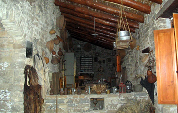
Galluras Museum - Museum of the femina agabbadora
The Museum of Luras is located on the main street of the village, in a typical three-storey house of the Alta Gallura district.
The rooms and fixtures have been restored to reflect the structure and the balance of the traditional homes of Gallura.
The museum is spread over all three floors, in halls which accurately portray the typical environments of local culture between the late 1600s and the first half of the 20th century. The museum showcases more than 4000 objects from the small town. The ground floor is composed of various halls: the Audiovisual Room is equipped for viewing videos, has computer stations for information and bibliographic searches. Hall 1 centres on grape-growing and winemaking activities, displaying the traditional tools and objects used in the vineyard and in the winery. Of special interest are 'sa cascietta', the open wooden barrel for grape stomping, 'sa suppressa', a wooden press dating from the late 17th - early 18th century, and an alembic. Hall 2 and the courtyard display the tools and implements once used by farmers in the fields, to process cereals, for animal husbandry, milking and dairy production, and harnesses and devices for tending farm animals.
The first floor is a perfect reconstruction of a traditional home, with the dining room which was the heart of family gatherings and conversations. It is furnished with a cupboard, a wooden chest for storing bread, the 'piattéra', a wall-mounted plate rack, and a 'banca a fogliu', a very practical extendable table, which can be easily doubled in size, and the kitchen with the traditional 'banca 'e su pane', the bench for bread making, and the bedroom.
The second floor includes two halls: one hall with traditional equipment for spinning and weaving woollen and flax, items of clothing and fabrics and another illustrating cork production and processing, an important local activity.
The Museum also has a famous, sinister tool, the hammer that in past times was used by 'sas accabadoras', the women in charge of 'bringing to an end' (from the Spanish 'acabàr') the suffering of the terminally ill in their deathbed. It is a olive tree club, 40 cm long and 20 thick, with a handle allowing a firm grip.
Address: via Nazionale 35a, Luras Phone: 368 3376321 Manager: Piergiacomo Pala.

Pòglina - Spiaggia Corallo
'Poglina', that comes from poddine, meaning 'flour', like its fine, weightless sand; 'Corallo', meaning coral, because of the gleaming sandy stretch, 'della Speranza' meaning ‘of Hope', from the locality in which it is located that, in turn, gets its name from the little church of Nostra Signora della Speranza (Our Lady of Hope). These are the three names for which the beach is known. It is a gem on the coast of Villanova Monteleone, a historical village located in the Alghero hinterland, 16 kilometres from the sea and it 'administrates' a 14-kilometre stretch of coastline. You can get to it along Provincial road 49 towards Bosa, eight kilometres south of Alghero, or from the new Provincial road from Villanova to the coast. You will find a wide stretch of about a kilometre and a half of fine, light sand bathed by a bright blue sea, quite sheltered but often rough due to the northwesterly mistral wind, making it popular with windsurfing and surfing enthusiasts. The sand slopes gently and continues to do so in the water too: beneath the shallow waters, the seabed is sandy and dotted with rocky outcrops. On the beach, there is a refreshments point and bathing equipment rental. The car park is also suitable for parking camper vans. In the north stands the ancient tower of Poglina, built during the Spanish domination, from which there is a splendid view: behind the stretch of sand, you will see dense and colourful Mediterranean scrub.
Poglina is the seashore of Villanova, one of the few sandy stretches, along with the beach of sa Murena (on the border of Bosa), surrounded by high (up to 500 metres), jagged cliffs from which steep torrents descend, forming the waterfall of s'istrampu de su Segnore. The Villanova territory is dominated by mount Minerva, a spectacular bastion of volcanic origin with a flat peak, covered in forestland. The village, not far from which there is also Lake Temo, is renowned for its textile art and weaving. In the village centre, you can visit the sixteenth-century parish church of San Leonardo da Limoges, rebuilt in neo-Gothic style in 1789, and the ethnographic museum of sa Domo Manna. Other places of worship are the seventeenth-century church of Madonna del Rosario and, three kilometres from the village, Nostra Signora di Interriors, where the festivities in honour of the Nativity of the Virgin Mary (8 September) are held, as well as those in honour of St John the Baptist, at the end of August. The greatest inheritance from prehistoric times are the domus de Janas necropolis of Puttu Codinu and the archaeological park in which you will find the trilobed nuraghe of Appiu, a village of approximately two hundred huts, another monotower nuraghe, a Tomb of Giants with two dolmens, a megalithic circle and a megaron temple.