
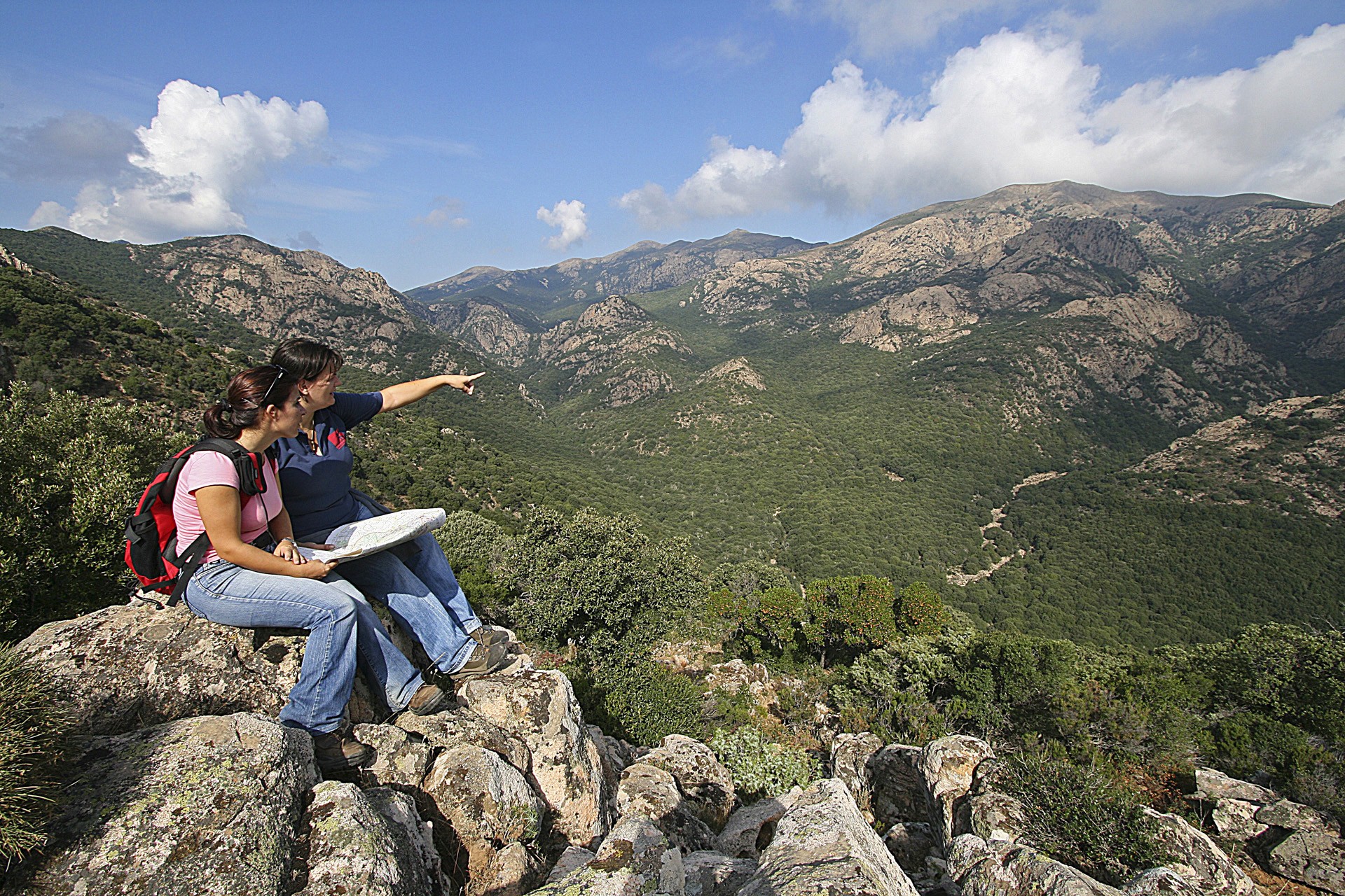
Monte Linas
An alpine landscape with wild peaks, deep gorges and sloping walls. Monte Linas is made up of granite rocks dating back 300 million years and is one of the most ancient landmasses to have emerged in Europe. It is located on the eastern border of the Iglesiente area, downstream of the Cixerri river, and it borders with the mountains of Arcuentu, to the north, and Marganai, to the south, to which it is connected by the Oridda plateau. It occupies nearly one thousand square kilometres in the territories of nine municipalities in the Medio Campidano area.
With its pink and grey granite peaks, it has almost eight thousand hectares of woodlands, made up mostly of holm oak forests. Thyme and helichrysum bushes fill the air with their fragrance, popping up between Mediterranean shrubs like strawberry trees, heather and phillyrea. At lower altitudes, you will find mastics, broom, wild olive trees and, near bodies of water, oleanders and willows. The lush vegetation is a home to several Sardinian red deer as well as wild boar, weasels, martens and foxes. If you look up, you might be surprised to see, flying overhead, the golden eagle, the peregrine falcon and the Eurasian sparrowhawk, which nest on the highest aiguilles, and the beautiful colours of the buzzard, the jay and the hoopoe.
A network of paths lead into the woods: you can enjoy trips on foot, by mountain bike and on horseback. The complex has various gorges and gullies with torrents that descend downwards and create spectacular waterfalls: you will be charmed by Sa Spendula, Piscina Irgas and Muru Mannu, which falls from a height of over 70 metres and is the highest waterfall in Sardinia. The mountainous landscape is located in a metalliferous area, which has been widely exploited. All around, there are the ruins of mining plants: Montevecchio, Ingurtosu and Perd'e Pibera, where there is a park. From here, by following the signposted trails, you will get to the highest point: Perda de sa Mesa (1236 metres). On the summit you can enjoy breathtaking scenery. A park named after the writer, Giuseppe Dessì, occupies the westernmost part of Linas, while in the limestone areas, towards Marganai, underground rivers flow and have created long underground caves over time, among which the beautiful cave of San Giovanni is really worth seeing.
Villaperuccio
Stretching on a plain in the heart of Sulcis and known as Sa Baronia, Villaperuccio is a town with just over 1,000 inhabitants that became an independent municipality (from Santadi) in 1979. The current urban centre was born perhaps upon the arrival of monastic communities between the 11th and 12th centuries. Symbolising the comparison with the first settlements is the medau or furriadroxiu (small rural agglomerate) of Is Meddas, a hamlet of the village, which conserves its original structure - a central courtyard overlooked by low-rising farmhouses and a little landowner's edifice. In the village stands the parish church of Madonna del Rosario, built in 1913 thanks to the donation of a wealthy landowner. The patron saint is celebrated at the end of August. In the town, at Is Grazias, stands the Sanctuary Madonna delle Grazie (16th century), alongside which the remains of a Roman necropolis have been found. Festivities are held in the town church in July, whilst the Sagra dell’Arancio (orange festival) takes place in March.
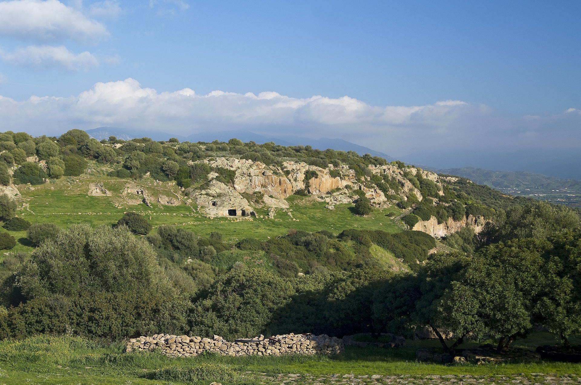
The territory of Villaperuccio consists of an alluvial plain to the south and a semicircle of hills of volcanic origin that enclose the plain to the north. From the hills set out streams that flow into the Rio Mannu, which in turn flows into the Monte Pranu lake. This land has been inhabited since the recent Neolithic period, as is evidenced by many pre-Nuragic remnants. A little more than a kilometre from the lake is the necropolis of Domus de Janas di Marchianna. At the peak of s'Arriorxu are the remains of a cultural village of Ozieri (3rd millennium BC), which was headed by the largest Domus de Janas burial ground in southern Sardinia, the necropolis of Montessu, which opens on the southern flanks of the Sa Pranedda hill, a few kilometres from the village in a beautiful natural amphitheatre. It has 40 sepulchres of various sizes and layouts, mostly multi-chambered (with anti-chamber, main chamber and secondary chambers). The rooms are preceded by vestibules and have niches and cupels, with entrances once closed by doors. The two hypogea at the ends of the rocky amphitheatre are distinguished by their monumentality, flanked by two Domus of great significance in symbolic religious terms (tomb-sanctuary): the 'tomb of spirals', decorated with wolf’s teeth in red ochre and with numerous spirals symbolising the eyes or breasts of the Mother Goddess, candelabrum motifs and false door (a passageway to the afterlife); and the 'tomb of horns', where horns of various shapes, alluding to the god Taurus, are carved. The site was used for a millennium until the late Aeneolithic and Ancient Bronze Age (2400-1600 BC). Not far from the necropolis are two imposing perdas fittas: in the locality of su Terrazzu, the menhir of Luxia Arrabiosa - the protagonist of many a popular legend - and another menhir six metres high atop Monte Narcao. Other menhirs, in trachyte or granite, are Is Perdas croccadas, Is Pireddas, Is Melonis, Bacc’e Fraus, Is Faddas and Is Cotzas. From the Bronze Age come the ruins of 40 small and medium Nuragic structures and a Nuragic hut in the village, close to the town hall.

Monte Arci Regional Natural Park
The largest source of obsidian in Sardinia, hidden in the bowels of a volcanic mountain. The green cloak of the Monte Arci massif rears out of the Uras plains, to the far north-east of Campidano, covered by basaltic lava flows that reveal its origins and history over the millennia. The volcanic chimneys culminate in its peaks: the 812 metre high Trebina Longa, 795 metre Trebina Lada and 463 metre Corongiu de Sizoa. Three peaks that bring to mind a tripod.
The area of the Acri regional park (270 squarekilometres) includesland from elevenmunicipalities in the Oristano area - Ales, Marrubiu, Masullas, Morgongiori, Palmas Arborea, Pau, Santa Giusta, Siris, Usellus, Villaurbana and Villaverde.
The obsidian, rarely found in the Mediterranean and ideal for making prehistoric weapons and tools, attracted ancient populations since the 6th millennium BC, who journeyed to Sardinia in order to stock up on the precious mineral. The deposits in PerdasUrias, s’Ennixedduand Su Forru de is Sintzurreddus (at Pau), Roja Cannas (at Masullas) and the Santa Luxia plateau (at Usellus) were points for collecting and working it. In Pau Museum, you can find out about the thousands of years of history created by obsidian. Contemporary sculptures made from huge, black blocks can be found around the town. Museum guides are available to take you on excursions to the quarries. General La Marmora stated that he had never seen such a large quantity of the black, shiny stone anywhere else. While you're in the park, also look out for the Brunk’es’Omu (at Villaverde) nuraghe and the Domu de is Coambus cave sanctuary (at Morgongiori).
Most of the area on the mountain is covered with holm oaks with occasional cork trees, downy oaks and Mediterranean brush. A splendid example of holm oak forest can be found at s'Acqua Frida in the territory of Ales, rich in springs. The woods are inhabited by wild boars, weasels, pine martens and foxes, while roe and fallow deer have been reintroduced. Overhead, you can spot wood-pigeons, finches, jays and hoopoes, while birds of prey nesting here include goshawks, sparrowhawks, lesser kestrels and peregrine falcons.
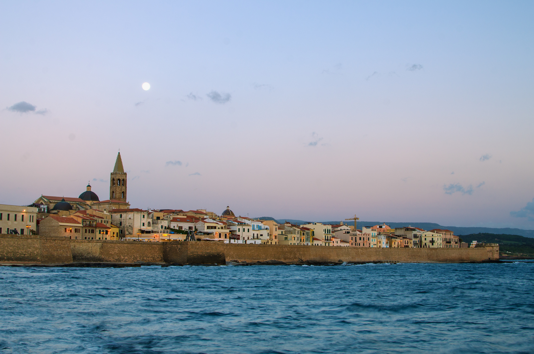
Walls and bastions of Alghero
One of the few Italian cities that have preserved their walls and towers intact. Today its bastions, dedicated to great explorers – Columbus, Pigafetta, Magellan and Marco Polo, have become an interesting walk. Alghero was built between 1102 and 1112 by the Doria family, and its first fortifications were raised a few decades later. By late 13th century, it was increased, while during the Aragonese domination no substantial modification was made to the city, and it preserved its Genovese plant with 26 towers. Thus it was until the 16th century, when the walls were rebuilt: the sea-facing part was completed, but the land-facing part was not. In 1867 Alghero was excluded from the list of strategic cities, and the dismantling began. But everything (or almost) that once was has resisted and can still be seen: the seaward walls and eight 16th-century city towers (plus 11 along the coast).
The Porta Terra tower was the Porta Rejal, the entrance to the city when you arrive from Sassari. The San Giovanni tower was the “middle tower”, what the Sulis is famous for the gruesome night battle that took place between 5 and 6 May 1412: a few Alghero inhabitants opposed the troops of William III of Narbonne. It is named after a Cagliari tribune who stirred up public upheaval in the late 18th century, condemned and then sent to prison for over twenty years. The urban perimeter also include the towers of San Giacomo, della Polveriera (the armory) and of sant’Elmo, named after Erasmus (Elm, in Catalan), the sailor saint. Within, in bas-relief, is the coat of arms of the Crown of Aragon. Finally, the Garitta Reale, an outpost at the extremity of the Marco Polo bastions, and the Maddalena tower, with protruding outlets from which boiling oil and water could be poured onto the enemies below. It is also called Garibaldi’s tower, after the hero who was here in 1855. To the south, along the panoramic road to Bosa, two other towers stand, while to the north, between the park of Porto Conte and Capo Caccia, there are six: the most beautiful of which is the Pegna, built on a promontory by coral fishermen. There are an additional three at Porto Ferro.
Cala dell'Argentiera
A ghost village next to mountains of silvery slag and fascinating ruins from a distant mining period is now an innovative open-air museum. There are also cliffs overlooking crystal clear waters, spectacular coves and expanses of white sand, places where you can alternate relaxation on the beach with hiking explorations. This is the landscape of Argentiera, a hamlet of Sassari - 43 kilometres away (by first taking state road SS 291 and then provincial road SP 18) - once a flourishing village and a major mining district in northern Sardinia, thanks to rich deposits of zinc and argentiferous lead, known since ancient times. Today it is one of the most fascinating sites of industrial archaeology in Europe, an integral part of the geomineral park of Sardinia, as well as a peaceful seaside resort, halfway between Alghero, Stintino and Porto Torres and it is never crowded, even in the height of summer. A few farming families live in the village all year round.
The ruins of the old mine look out onto the turquoise sea. Around it, there are sheer rock faces and promontories covered with dense Mediterranean scrub, which delimit wildly beautiful bays that are accessible from the sea or by land along steep paths through unspoilt nature, ideal for trekking. Spectacular scenery, the set of the opening scene of ‘Boom!’, with Liz Taylor and Richard Burton (1968). The upper coast is interrupted by three sandy coves: in Porto Palmas, near the Businco rock and the cala dell’Argentiera, once used for loading minerals, which were taken on board and then transported on boats. The cove is made up of two semi-circular beaches, separated by a small cliff. The sand is firm, medium-grained and has a light amber-greyish colour due to the mineral powders. The largest of the beaches almost opens up onto the main square of the village and is the scene of a literary festival at the end of July. The smallest beach, located to the south, is known as Cala Onano and is dominated by a mining village that emerged in the early 20th century and by the washery building made of pitch-pine wood, built in 1936 and now one of the most unique mining monuments. The bay has shallow waters and a sandy shore, with rocky plateaus further out: spurs with ravines and cavities stand out and this is the habitat of a great variety of life forms as well as a destination for snorkelling enthusiasts. You can rent beach equipment, pedaloes and canoes here. There is no shortage of refreshment areas and ample parking, also suitable for camper vans. There are restaurants and bars nearby.
Two dirt roads start at the little village and lead to the cape and to the tip of the Argentiera. Two kilometres to the south, you will encounter Porto Palmas, the only landing place within a few miles. The beach is a spectacular crescent of white sand amidst dark rocks, with low cliffs on either side protecting it from wind and currents. To the north of the Argentiera, you can travel in an off-roader along a dirt road that runs parallel to the cliff for a few kilometres: you can admire smooth lava rocks, shaped by water and wind, that looks like a lunar landscape in some stretches and encircles coves with panoramic viewpoints. The road, which is now paved, continues as far as the wild beach of Lampianu, near the now-abandoned village of Nurra, and reaches punta de Lu Nibaru, in front of the Businco rock.
Mining activity at the Argentiera started in 1867 and lasted exactly one century. The mine changed hands many times, passing from one company to another, with ups and downs, while the peak of its development was between the end of the 19th century and the first few decades of the 20th century. This significant and interesting legacy recently entered a phase of development, starting from the environmental regeneration and urban renewal of the little village, continuing, in 2019, with the construction of the Open MAR, an innovative open-air museum, where historical memory, art and new technologies meet each other.
Montevecchio Museum Complex Piccalinna Route
The Piccalinna mine, in Guspini, opened in 1874, spreads over some 370 hectares underground. Initially operated under a concession by the Italian-French company Nouvelle Arboree, in 1897 it was sold to the Società Montevecchio.
The company reorganised both the surface installations and activity at the mine faces, returning the mine to full-scale activity up to its closure in 1981.
The mine compound has fine masonry buildings with brickwork decorations on the facades, built with an eye to style, and which were once the operational heart of the mine works. Other buildings, now derelict and sunk in vegetation, were the living quarters of the unmarried miners: these are seven buildings in all, built in the 1940s, which were added to two earlier ones, constructed in the late 19th century when the shaft of San Giovanni was opened.
On the opposite side, perched on a hill overlooking the mine works stands a stylish plastered building erected in the early 20th century. Adorned by string-courses, pilaster strips and door and window trims in stone, it served as living quarters for the mine foremen.
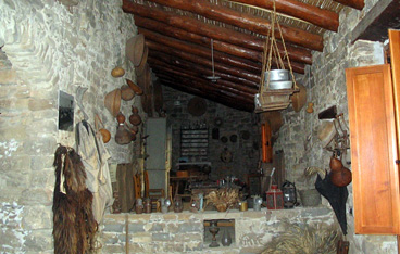
The head of the Shaft of San Giovanni, the lamp-house, the hoist room, the compressor building (made in exposed basalt stone with masonry elements in the late 19th century), the electric power station, the Piccalinna ore treatment plant, the office building and the smithy are the main above-ground structures in the mine compound. The hoist room (spool type, with flat cables) still preserves the imposing hoist engine, originally steam-powered, subsequently, from the 1930s, electricity-powered.
The compressor room housed the equipment for producing compressed air, in the mine to treat the water supplying the ore treatment plant and providing motive force to the drills and other machinery used both above and below ground.
Address: Cantieri di Levante SP 66 Km 5 . Guspini-Montevecchio Phone info point +39 070 973173 . Cell phone +39 389 164 3692 Managing Agency: Municipality of Guspini
Giba
Based on tradition, its founding dates back to the Vandal king Genseric in 500 AD. Giba is located on a plain surrounded by low hills, a few minutes from the sea. The main residential area and district of Villarios, situated along the Karalis-Sulki Roman road (Sant'Antioco), have over two thousand inhabitants. The fertile territory facilitates the production of excellent oil and Carignano wine, artichokes, to which a festival is dedicated in mid-March (at the same time as the festivity in honour of St Joseph), and cheeses. The bread is baked in traditional ovens: at the beginning of August, in the bread festival, as well as the typical local dishes, you can taste several variations: civraxiu, coccoi, pan 'e saba, bread with olives, Ricotta cheese and Lardo. There are delicious pastries (gueffus pabassinas, pardulas and pistoccus) and works of art, like the textile goods: rugs and tapestries. The local artisans also offer you knives, baskets and Is pippias de cane, little dolls made of reeds.
Around the village, the gentle hills, covered in Mediterranean scrub and centuries-old olive trees, look out onto the Gulf of Palmas. On the beach of Porto Botte, now frequented by kite surfers, the infant Alfonso disembarked 1323: it was the beginning of Spanish domination that lasted four centuries. Next to it, there is a lagoon, the habitat of black-winged stilts, western marsh harriers, greater flamingos and the western swamphen, an attraction for birdwatching enthusiasts. Nearby, there is the lake of Montepranu, ideal for recreational fishing enthusiasts. Approximately 15 kilometres to the south, you will find the beaches of Sant'Anna Arresi and Teulada.
Giba has been inhabited since the Neolithic period, as is confirmed by the Domus de Janas of Is Gannaus, dating back to 3500 BC. Dating back to the Bronze Age, there are various types of Nuraghi, among which Nuraghe Villarios, which was built to control the coast, and above all the complex (in excellent condition) of Nuraghe Meurra (12th century BC), on the border of San Giovanni Suergiu and Tratalias, which also includes a village, a sacred well and a Tomb of Giants. There is no lack of Phoenician-Punic evidence, while traces of Roman times are even clearer: the ruins of two villas, the remains of a road, a bridge and thermal baths. It is assumed that the village was founded during the Vandal invasions: North Africans from Mauritania were deported and left their facial features as a legacy in the Sulcis area. At the end of the first millennium, the Benedictine monks of Montecassino and the Monks of Saint Victor of Marseilles gave impetus to the community and the territory, building monasteries here (one is still intact in the outskirts) and Romanesque churches, among which that of Santa Marta is still standing in Villarios (perhaps built in 1066), on a high ground: from above, you can admire the shoreline and the Sinis archipelago. St. Marta is celebrated at the end of July, while the patron saint, Peter, is celebrated for three days at the end of June. An evocative procession takes place with a parade of worshipers in traditional dress, horsemen and launeddas players.
Badesi
Set between Anglona and Gallura, on the far eastern rim of the Asinara Gulf, this is a coastal town whose origins are relatively recent. The area it occupies began to be settled in the XVIII century, perhaps by a family of shepherds, and it gradually became a village that is now nestled around the Sacro Cuore church built there in the early 1900s. The town’s patron saint is celebrated in early June. Four suburbs later came into being on the plains surrounding Badesi.
The beaches of Badesi Mare are of uncommon beauty. Li Mindi is a wide beach of white sand graced with marvellous colours that stretches for kilometres on end, and over which the Coghinas delta passes, one of Sardinia’s most important rivers. The fine sand dunes are home to juniper trees, the island of Asinara lies on the horizon and the view spans from Castelsardo to the isola Rossa. Towards Valledoria you’ll find the famous and bustling Baia delle Mimose, a stretch of white sand bathed by the blue water of the sea, blessed with a shallow sandy bottom, framed by dunes covered in coastal vegetation.
Thanks to its exposure to mistral winds, the shore is the ideal place for windsurfing all year long. The coast has been declared an EU Place of Interest for its thick vegetation and unusual fauna, in particular marsh and migratory birds that nest among the reeds along the Coghinas river and on its islands. All around are gently rolling hills and sloping fields that are home to vineyards whose grapes are used to make the prestigious vermentino di Gallura wine.
With the arrival of summer, the area attracts a myriad of visitors to the Estate Badesana, a series of events that includes the famous summer carnival (on the night of 13 August) and a food festival (8 August) featuring local cuisine and traditional delicacies. In May there is the trofeo Magrini, an international surfcasting competition along the shoreline.
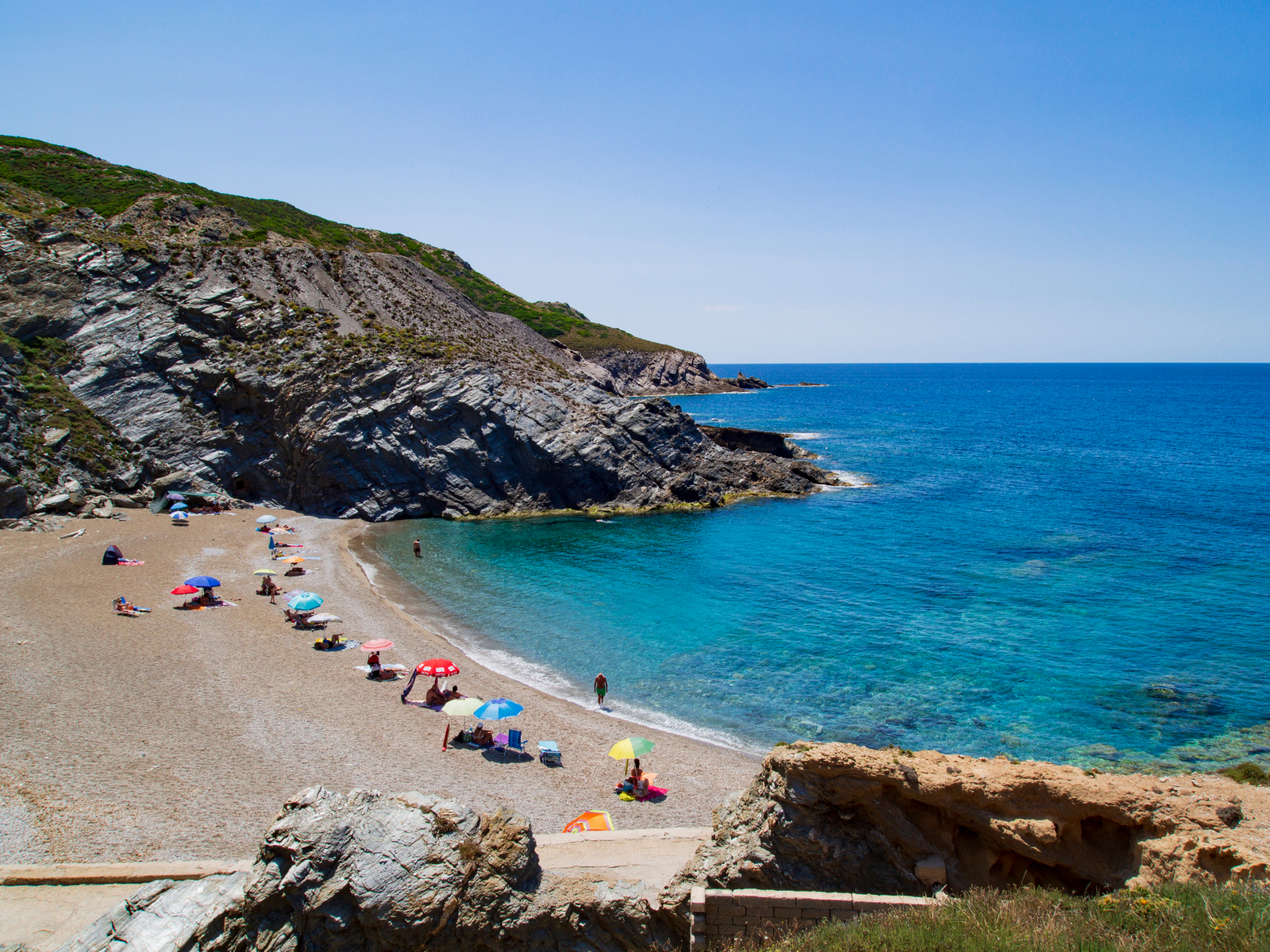
Cala Lunga - Isola di San Pietro
The bay of Cala Lunga, in the locality of La Punta on the Island of San Pietro, is a rock cliff which plunges down into the sea. Its waters are of a changing blue due to the plays of light created by the sun reflecting off the sea bed. The bay is positioned between La Punta and Le Tacche Bianche, this latter an imposing vertical cliff. Out to sea, some few hundred metres from the shore, fishing nets can be seen which are used to catch the precious tuna fish which is exported from the Island of Carloforte as far as Japan, one of this activity’s best clients. The Island of San Pietro also includes the two smaller islands of Piana and Topi, and is separated from the Island of Sant’Antioco by the Colonne channel. Its coastline is jagged with caves and vertical cliffs but more sandy on the western side. The only town is Carloforte, founded in 1738 by a group of Ligurian fishermen hailing from Tabarka in Tunisia. The town can be reached from Calasetta and Portovesme in about 30 minutes by ferry.
Marghine
The mountain ranges of Sardinia, like those of nearby Corsica, are not the continuation of the Italian ones, unlike the French Maritime Alps. In reality, however, Sardinia doesn't possess real mountain chains and also those that seem as such are in effect alignments of ancient pits. Among these are the chain of the Marghine and that of the Goceano, that are positioned in succession as a single west to east alignment in the central-northern area of the island. The mountainous system of the Marghine, that covers a large surface area, falls within a number of municipal areas. Bolotana, Borore, Bortigali, Dualchi, Lei, Noragugume and Silanus are the towns in whose territory the chain of the Margine falls, together with Macomer, the small town that acts as the main town of this region. The Marghine, that has its highest peak at Punta Palai (1200 m) in the territory of Bolotana, is in reality the edge of a highland, that culminates in a series of trachyte peaks that have the characteristic forms of towers. It is a territory of great naturalistic value, with points of extreme interest, like the woods of Downy oaks or the springs that mark Monte Santu Padre (1120 ms) in the territory of Bortigali or the volcanic peak of Monte S. Antonio di Macomer (808 m), from which a spectacular sight can be had of the Planargia, Montiferru, Gennargentu, and on the clearest days also as far as Campidano. Its name is probably connected to the strategic function that these high ground offered right from the Punic age (the name Macomer is of Semitic linguistic origin) and then mostly in the Roman era, when the area of the Marghine became the border between the more Romanised areas and those in which the penetration of the new conquerors met a greater number of obstacles. This is the area that, together with the Goceano, has the greatest concentration of prehistoric and proto-historic monuments in Sardinia, probably for more than one reason. Undoubtedly the increasing amount of research, allied with the position of some sites that are distant from the modern traffic arteries and more urbanised areas, has lead to the discovery of a large number of well-preserved monuments. A must-see in the territory of Macomer is the archaeological area of Tamuli, with a nuraghe, three giants’ tombs and six conical menhirs, of which the three largest (between 1.24 and 1.40m in height) show two mammillary ashlars. Of great importance for the history of Sardinia is also the domus de janas necropolis of Filigosa, from which the bronze age culture of Abealzu-Filigosa takes its name. At Birori the giants tombs of Palatu and Lassia are of great interest. In Bolotana a small, but fascinating park can be visited, in the locality of Badde 'e Salighes, set up at the end of the nineteenth Century by the English engineer Benjamin Piercy who was in charge of building the Sardinian railroads, who around his own Liberty style villa (also within in the grounds of the park) had a large number of plants and aboriginal and exotic trees planted that today give life to a garden of remarkable botanical interest.