
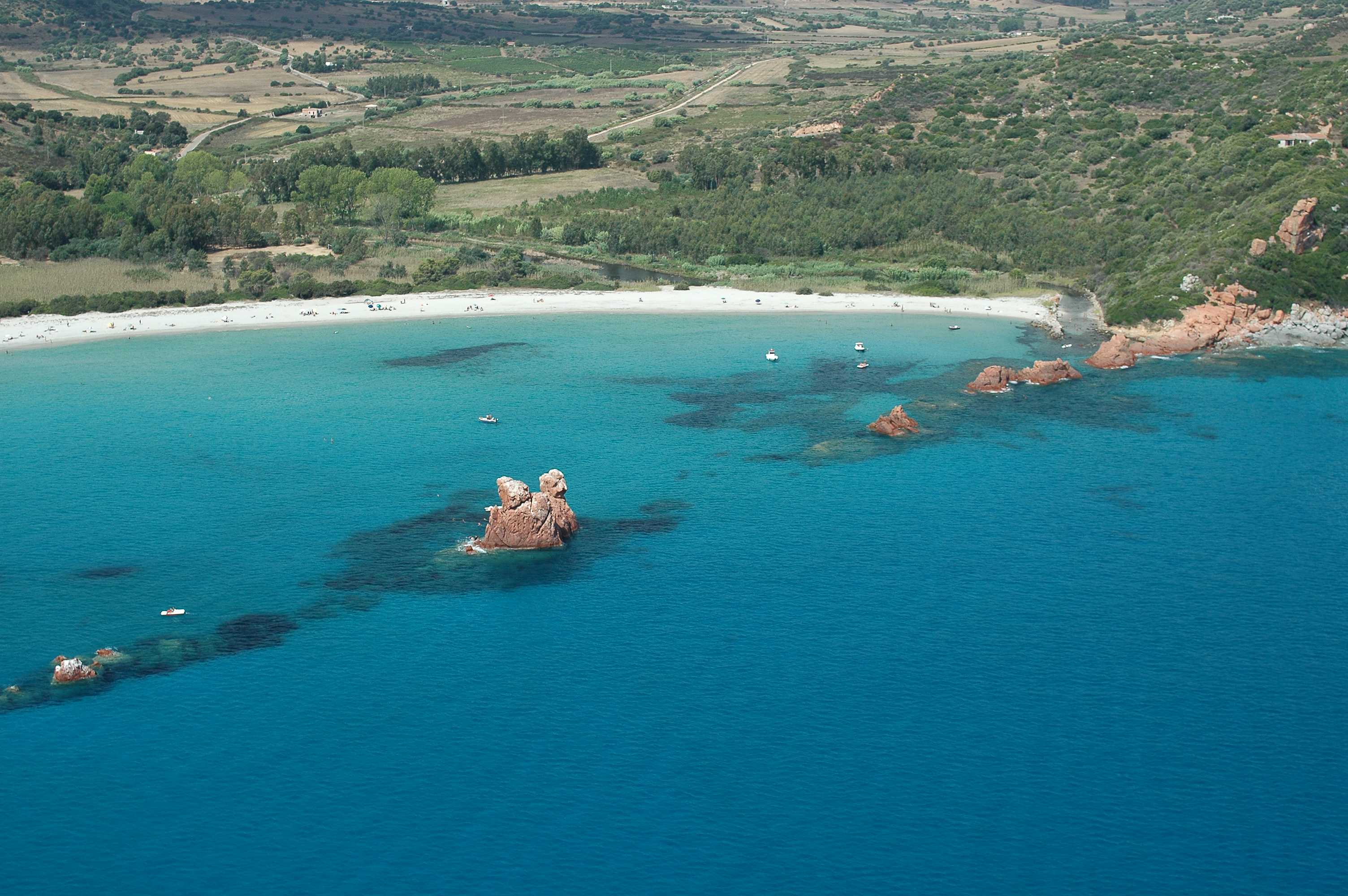
Cea
Soft, white, weightless sand, shallow waters, smooth rocks and the sunlight highlighting the emerald green nuances of the sea. The beach of Cea is more than a kilometre long. Three quarters of it belong to the territory of Tortolì, a town just a few kilometres along the coastline of Orrì, and the other quarter is on theBarisardo coast, which is about seven kilometres away. To the south, it is delimited by a row of rocks, Punta Niedda, while a little further on, there is the volcanic rock of the Plateau of Teccu. Walking here is a sensory experience: the sand is silky to the touch, the scent of the junipers and Mediterranean scrub, the sounds of the sea and its colours all make it a memorable part of your holiday.
From the nearby hill, a ridge of red porphyryends as a beach. In the same direction, 300 metres from the shore, in the centre of the coast, two twenty-metre high sea stacks appear: Is Scoglius Arrubius, which lights up at sunset in a spellbinding show of colours. They are the symbol of Cea, and you can swim to them or reach them on a pedalo.
The beach has places for dining/refreshments, ample parking and equipment rental. There are also services for the disabled and walkways that lead to the water. A little way beyond the beach, a small cove with rocks and stones makes it possible for pleasure boats to dock there. Behind it, there is dense vegetation and next to it there are little ponds, linked to the sea during high tide, where you can fish for grey mullet.
Heading north, in the territory of Tortolì, you will find another picture-postcard location, Lido di Orrì, 16 kilometres of coastline consisting of little coves and small deserted beaches, among which the splendid Cala Ginepro. Then, in the territory of Barisardo, you can visitthe beach of Torre di Barì, symbol of the municipality located in the Ogliastra area. On the subject of red granite, near Arbatax, which is a district and port of Tortolì, don't miss a chance to admire the beach of the Rocce Rosse(Red Rocks), which act 'as a shield' to another dreamlike area, the 'city' beach of Cala Moresca.
Nuraghe Voes
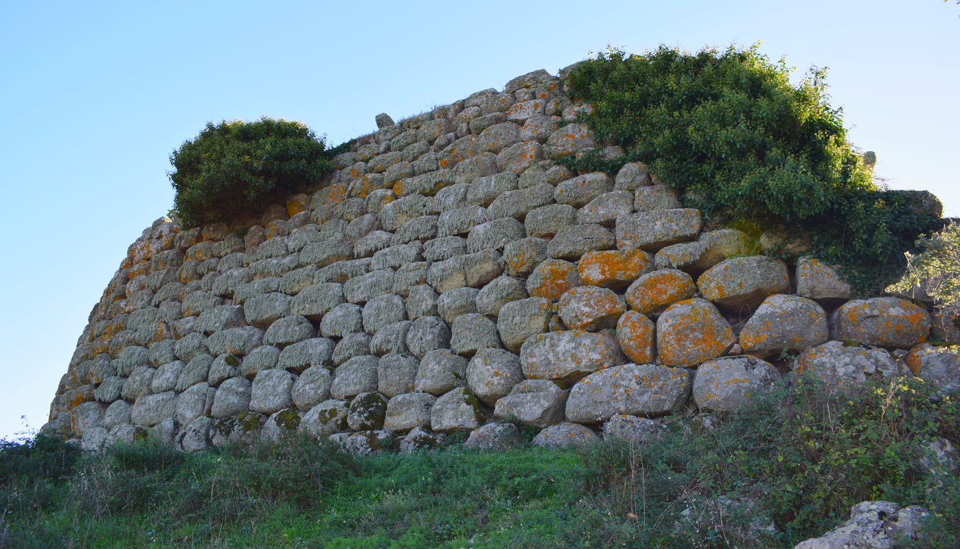
It is by far the most significant Nuragic legacy of Nule, an area with a high density of prehistoric remains and one of the best preserved in central-northern Sardinia. Perched at 700 metres at the south-western high plain of Buddusò, the Voes nuraghe dominates a panorama that spans all of the mountains of the Goceano, all the way to the valley of the lower Tirso river. The monument is located about six kilometres from the small town famous for its textiles and, above all, for its elegant carpets graced with framas designs, whose roots can be traced to the late Roman-high Middle Ages.
The monument is grandiose and its fundamental components remain intact, although they were never maintained or even the object of archaeological digs. Dated to the between the middle and late Bronze Age (1600-1000 BC), Voes was subsequently inhabited in later eras, as proven by a fragment of Punic ceramics and a hoard of copper and silver coins from the Imperial Age found there. The structure is a complex one, made up of a central tower which, it is believed, was once composed of three storeys. Around it, added at a later date, is a tri-lobed bastion: the three towers are connected by a corridor and laid out concentrically. At the entrance is a short corridor that leads to a small rectangular courtyard. The walls have openings that lead to the corridors that provide access to the rooms of the central tower and secondary spaces. The tower, aside from the circular room, has three niches set in a cross pattern with a tholos roof. To the left is a spiral staircase that leads to the rooms of the upper floor, where there are another three corridors that lead to the three secondary towers. The curved line of the tower makes it similar to the famous Santu Antine nuraghe at Torralba, while the bastion bears resemblance to the Losa nuraghe at Abbasanta.
The entire area around Nule is an open-air archaeological museum that includes a wide variety of Neolithic settlements, from dolmen to menhir, and plenty of Bronze Age remains: 18 nuraghe with surrounding villages, three giant tombs. The village of Santu Lesei is also of great importance, famous for the little bronze statue of Nule, an image featuring the body of an animal with the head of a man. It can be seen at the National Archaeological Museum of Calgari. At the end of the archaeological excursion, in the centre of Nule, a town made up of narrow streets lined with ancient stone houses, you can visit the XVI century former church of Santa Croce and the new church of Santa Maria Assunta, built in Gothic-Aragonese style, home to a wooden Baroque altar and valuable paintings.

Salina Bamba
The beach of Salina Bamba stretches out in one of the most beautiful coastal parts in north-eastern Sardinia. In fact, it is located between Cala Brandinchi and Baia Salinedda at Capo Coda Cavallo, in the commune of San Teodoro. Behind the beach we find an expanse of salt water that gives its name to the beach and home to interesting species of waterfowl The beach has extremely fine-grained sand, lapped by a transparent sea, whose turquoise hues mirror the stretch of the salt marshes. Furthermore the beach overlooks the Islands of Tavolara and Molara.
Santu Pedru necropolis
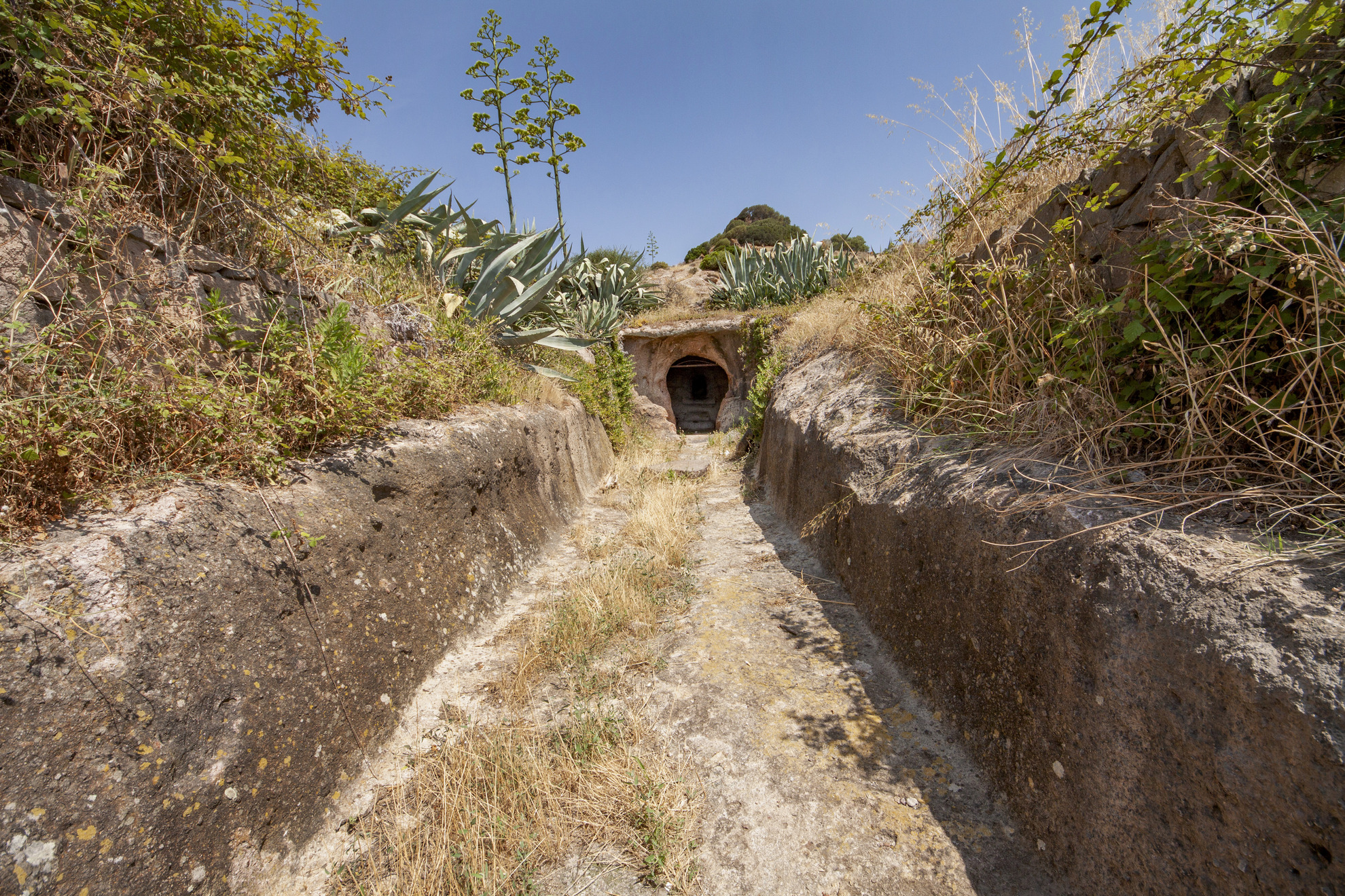
They were ‘abodes for the afterlife’, with decorations created to imitate the homes of the living, in order to maintain a symbolic link with the ancestors and grant them eternal rest in ‘familiar’ environments. Ten domus de Janas make up the necropolis of Santu Pedru, carved out of the trachytic tuff of a hill in the Nurra region during the 4th millennium BC, ten kilometres from Alghero, the ‘capital’ of the Coral Riviera. The collective Nuragic burials occupy the eastern slope of the hill, above which there is a nuraghe with a village of huts, and they remained in use, also for different purposes, until the early Middle Ages.
The tombs are considerably large in size and multi-cellular, meaning that they are made up of several rooms preceded by an entrance corridor, the dromos. Tomb 1, also known as the tomb ‘of the tetrapod vases’, stands out for its complexity and monumental appearance, as two four-footed ceramic vases were found there, in perfect condition. From the entrance, which opens onto the roadside, you will walk along a long dromos until you reach the semicircular anteroom. There, you will notice traces of red ochre paint near an opening decorated with architraves and cornices that leads to the main cell. Nine other rooms branch off from this room. In the main room, you will notice a false door, symbol of the transition to the afterlife, two pillars and a door with bull protomes. Columns, socles and other architectural elements suggest that Tomb 1 also served as a sanctuary.
The other tombs have similar characteristics, particularly Tomb 3, with an even greater number of secondary rooms. The primary cell of Tomb 5, which was never completed, contains a counter. You will also notice traces of red paint in Tombs 6 and 8. Tomb 4 occupies the highest part of the slope and has a distinctive feature: it was converted around the 6th century AD into a rock church that was dedicated, according to tradition, to Saints Peter and Lucia. The building has two apses containing small altars and a sculpted cross to the right of the entrance. Tomb 10 is separate from the rest of the complex and is located on the opposite side of the road, almost in front of Tomb 1. In the main cell, which has a rectangular plan, there are two pillars, a false door and traces of a hearth carved in relief on the floor. The domus de Janas with an extraordinary decorative and aesthetic value were the prerogative of Nurra algherese and Logudoro turritano: about 15 kilometres from Santu Pedru there is the famous necropolis of Anghelu Ruju, one of the most extensive on the Island; while five kilometres away stands one of the most spectacular domus ever explored, s’Incantu, the tomb of painted architecture, ‘showpiece’ of the necropolis of monte Siseri in Putifigari. Chiaroscuro painting, false doors painted red, pilasters, hearths and a relief of beamed roofs characterise the cell and anteroom, with continuous reference to bull’s horns. A little further north, in Olmedo, you can visit the fortress of Monte Baranta, with a megalithic wall almost ten metres long.
Coccorrocci
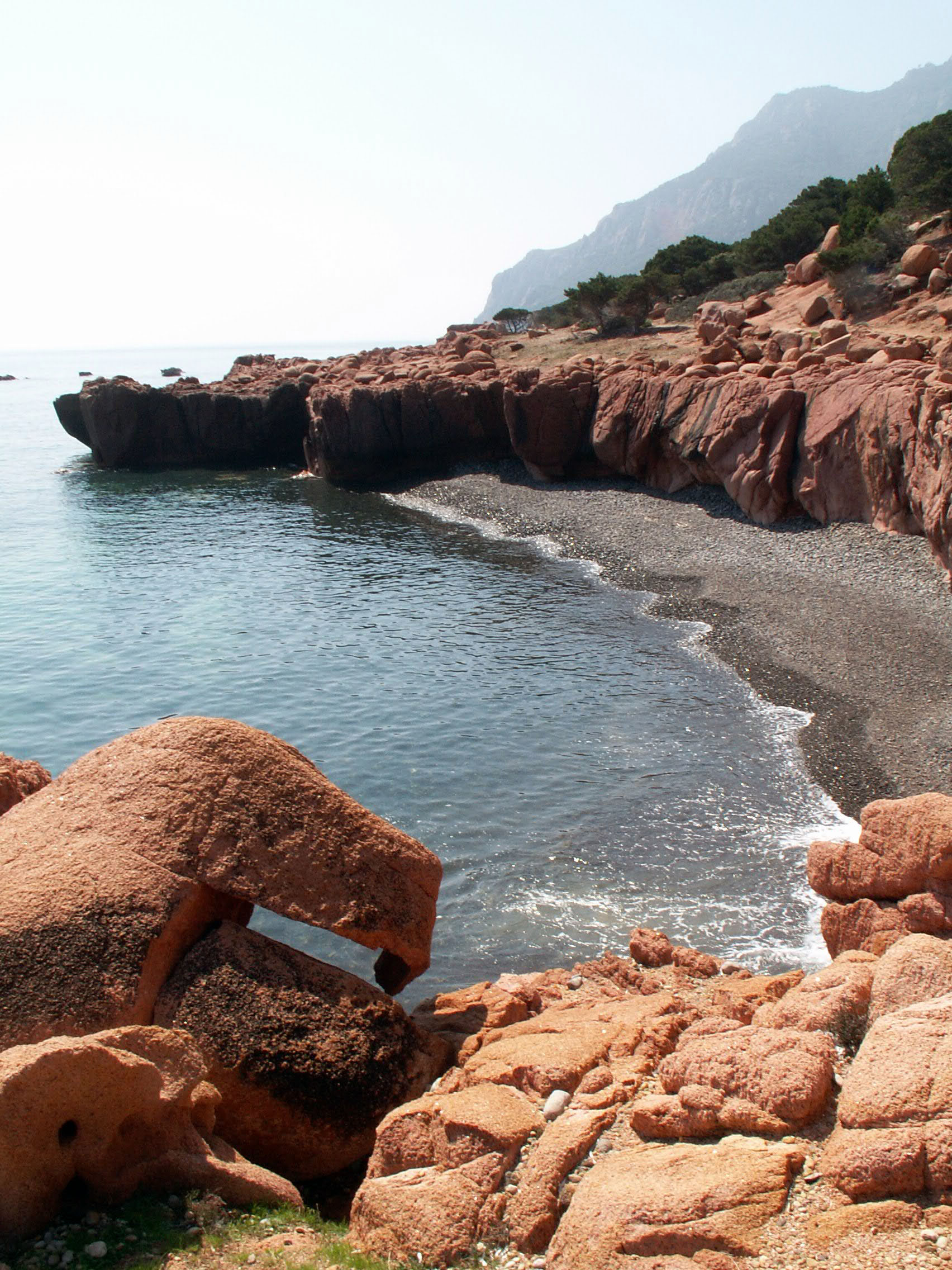
As many as four kilometres of pebbles shaped by time, the habitat of is coccorroccius, sea snails. The Coccorrocci beach, a pearl of Marina di Gairo, is named after these little animals, and is characterised by a very beautiful natural landscape. Mounts Ferru and Cartucceddu loom over the coast with their red porphyry rocks and juniper trees frame the beach with green and fill it with inebriating scents. The volcanic pebbles range from white to pink, from grey to greenish, and gradually fade as they disappear into the crystalline sea. Thanks to the clear water, you can admire the sea bottom, rich with marine flora and fauna. The shoreline is perfect for long, relaxing walks.
Coccorrocci, one of the most famous beaches of Ogliastra, is equipped with hotels. To the north, it confines with Marina di Cardedu, with the splendid Perdepera island in particular, and to the south with Marina di Tertenia, divided by a promontory you can cross in a long trekking session all the way to enchanting Foxi Manna beach. Along the Gairo coast, do not miss another little gem that looks like heaven: the su Sirboni beach (“the wild boar”), also called Cala Francese. Ultra-fine and white sand that dives into the clear azure sea with shallow bottom for many metres, lined with thick green vegetation. Never crowded, this beach has a wild, uncontaminated charm.
For lovers of active tourism, the beach is perfect for trekking, photography, bird watching, Nordic walking and orienteering. Not far from the beach – only a twenty-minute walk – you can enjoy the natural pools fed by the water from the su Accu ‘e axina spring, from Mount Ferru: red porphyry rocks emerge among the lush vegetation, embracing majestic water bodies where you can bathe as you like.
Monte Olia
One of the “historical” regional forests has a great picnic area, is ideal for outdoor activity, and boasts fabulous views from its highest reaches. The forest of Mount Olia spreads out over an area of 2,236 hectares located between the Monti and Berchidda territories. The forest sits on a substratum of granite and is home to holm-oak woods interspersed with conifers (domestic, black and Aleppo pines), downy oaks and young cork oaks, especially in the reforested areas. You will also notice many strawberry trees, heather, cistus and lavender bushes.
The altitude here varies from the 350 metres of the valley floor to the 811 metres of its highest point, the lookout post of Mesureris. Once at the top you’ll enjoy spectacular views that span from the Olbia valley in the north-east to the island of Tovalara, then to the Limbara massif in the north-west and to Lake Coghinas in the west. The fauna that lives here is varied: there are roe, deer, wild boar and mouflons, and it is also the refuge of a rare endemic species, the Bedriaga lizard, considered one of the most quick and agile of its kind in Italy. Eagles and red kites fly high above the treetops, while the rivers are home to Sardinian trout and stream trout. In sa Toa there is a natural pond, a picnic and camping area open in the summer, and trailheads that will lead you on hikes to explore the areas around the forest, especially heading towards the s’Eleme river, which marks the border between Mount Olia and the Bolostiu forest. Another great destination is s’Elighe, a natural pool, in Lada Pilosa. It is nestled in dense vegetation, and the surrounding area is dotted with pinnettas (straw shepherd huts) and wooden huts.
Now and again, you’ll hear the throbbing of powerful engines as Mount Olia is sometimes a venue for the Rally Italia Sardegna. Not far away, the territory is home to vermentino grape vineyards, the wine boasting DOCG status. Monti is an important vermentino wine district and there is a famous festival here in its honour in August, when you can sample fine local meals paired with it. The wine museum in Berchidda tells the fascinating story of winemaking in Sardinia. Berchidda lies draped over the southern slopes of Mt. Limbara and is famous as one the Sardinia’s jazz capitals, home of the Time in Jazz festival since 1988.
Monte Lerno
Total immersion in the purest and wildest nature, in a fairy-tale mountain landscape along the slopes of an imposing elevation. The forest complex of Monte Lerno, which is regional state property, extends for more than 2800 hectares in the territory of Pattada, at a height starting from 400 metres above sea level up to Punta Campanile, the summit of the mountain, at 1093 metres. Holm oak woods dominate this place, but there are also cork oaks competing with them, from which excellent quality cork is obtained, like in the locality of Trataxis. Entering the forest, you will also find downy oaks, holly plants, junipers and yews, while heather, strawberry trees, phillyrea and cistus are found in the thick undergrowth. The forest has been repopulated with protected species and, if you’re lucky, you will be able to admire the Sardinian deer and the mouflon, as well as a multitude of wild boar and hares.
In the artificial lakes of sa Pedrosa, sa Jone and sos Vanzos, you can admire colonies of mallards, while the golden eagle nests on the granite peak of the massif and you might also be surprised by hawks, sparrowhawks and goshawks flying overhead. Thanks to the patrimony of plant life and wildlife, the forest is a favourite destination for hikers and nature photographers, who also explore the area around Lake Lerno, an artificial basin at the base of the mountain. From here, you can take various paths on foot, by bike or on horseback. In the locality of Iscialzos, a convenient resting and picnic area has been set up.
On the shores of the lake, you can combine nature with archaeology. The nuraghe complex of the same name is here, built with granite blocks and consisting of a central tower and two secondary towers connected by a bastion. The keep still has its tholos roof, while the ruins of other adjacent buildings date back to the Byzantine age. Nearby, you will also see the remains of a medieval church, belonging to the village of Lerron that no longer exists and that gave the mountain its name.
Monte Lerno is a name also known to motor enthusiasts: it is one of the stages of the Rally Italia Sardegna, considered one of the most captivating, thanks to the hairpin bends and jumps: the spectacular Micky’s Jump, the photographers’ favourite as the cars pass by, has become the iconic image of the world rally. Lastly, a visit to the centre of Pattada is a must, to discover its artisan and food and wine traditions: the town is famous for its resolza pattadesa, a switchblade knife with a steel blade and mouflon horn handle and for its wooden objects, as well as its cheeses, pastas, breads and cakes.

Campidano
The State forest of Campidano covers an area of 1600 hectares in the territory of four municipalities (Sinnai, Settimo San Pietro, Dolianova and Soleminis), just a few kilometres north of Cagliari, the main reason for the high volume of tourists in the area. The highest peaks are Bruncu Baraccu (655 m) and Bruncu Cirronis (629 m). The historical body of the State forest was acquired by the forest administration around 1900, with the aim of starting the work of reforestation of the area.
Today, after the work carried out over the years, an area of particular interest is the well developed pine forest (Aleppo pines) of Sa Pira, also created with the efforts of the Austrian prisoners of World War I, and a small area of cork oaks planted in 1906 in area known as Is Landireddus. Sa Pira is also the location of the visitors’ centre and the Forest Authority buildings. The fauna includes rather common species, such as the wild rabbit, the Sardinian hare, the partridge and the quail, migratory birds, the fox, and, only in the more dense areas, the Sardinian wild boar.
At Bruncu Mogumu it is possible to still see the lay-out of an archaeological site under excavation and study: it deals with the remains of a Nuragic templet from the proto-historic period (Phoenician materials dating back to the 7th Century BC have also been found). Within the confines of the forest it is also possible to visit an interesting nursery at Mont'Arrubiu, where visitors are also allowed to take away some of the plants. Not far from here are the ex forest barracks, renovated and converted into a residential experience that provides environmental education, among which information, sensitisation and popularisation, organised by the Forest Authority.

Casa Deriu
Three museums in one, three levels with different exhibition spaces, all equally interesting and capable of taking you on a journey through time. Casa Deriu is one of the most distinctive buildings in the area known as sa Piatta in Bosa – the area of the historic centre near the Temo river -, inside which, by merging pre-existing houses together, a museum was created and it embodies the artistic and aesthetic spirit of the town between the 19th and 20th centuries. At the entrance, on each side of the two doors, you will notice pairs of columns made of local red trachyte, while in the entrance hall you can admire three arches, typical of Bosa homes of the past. One leads to the storehouses, the second to the stairs and the third has an ornamental function. From the ground floor, where the cellars were originally located, you can climb the stone staircase leading to the first floor: temporary exhibitions focusing on the traditions, habits and customs of the village are held here.
On the second floor you will travel back two centuries: it is entirely furnished like a 19th-century stately apartment. The visit takes place around a circular route. From the entrance, you can enter the lounge, with parquet flooring, decorated with geometric patterns that reflect the embellishments on the false coffered ceiling. The space communicates with the bedroom, with a majolica floor, where the original wardrobe is kept. You can then move to the dining room and, from here, along a corridor with wooden partitions, back to the landing.
On the third floor, there is a permanent exhibition dedicated to the artistic flair of Melkiorre Melis, born in Bosa in 1889. In addition to the paintings, you can also admire objects and artefacts (furniture, drawings and ceramics), including works dating back to the ‘African period’, inspired by his experience as director of the ‘school of indigenous art and crafts’ in Tripoli. The exhibition is organised into five topics: the entrance room is dedicated to his hometown, with references to Carnival and filet work, the typical lace embroidery of Bosa. The ‘Libya room’ displays panels, furnishings and canvases linked to African activity. A special space contains the archive of graphic and illustrative production; the post-war artistic phase is kept in the ‘Sardinian room’, with portrayals of shepherds and festivals, and in the ‘Nuragic room’, with works where Melis ‘reinterpreted’ the Island’s mythology in his own way.
The building in front of Casa Deriu is part of the same museum system and contains the Atza art gallery, which exhibits canvases by the artist Antonio Atza, one of the main Sardinian artists of the post-war period, from Bosa by adoption. You can delve deeper into the history of Bosa by visiting three other symbols of the town. These are the Castle of Serravalle, which dominates the village from above, the Church of San Pietro extra muros, the most ancient Romanesque church on the Island, and the tanneries, premises where the oldest local manufacturing activity took place: leather tanning.

Castle of Pontes
“Ghosts of the ancient Barons came down from the Castle ruins above Galte”. This is how Grazia Deledda made the ruins of the castle of Pontes eternally famous, in the pages of her masterpiece ‘Canna al Vento’. Today, it is an integral part of the Grazia Deledda Literary Park, an itinerary that includes the places mentioned by the Nobel prize-winning writer. From the 11th century, the fortress, built on a hill at the foot of Mount Tuttavista, which dominates the plain of the Cedrino river, performed a strategic function in protecting the connections between the eastern coast and the hinterland. At that time, Galtellì was an important religious and political centre of the Gallura Giudicato and in the 14th century it was attacked and conquered by the Aragonese Crown.
The castle was inhabited until the 15th century before being abandoned: its last owner was Baron Guiso, around whom there are numerous legends: his ghost would roam the ruins at night, unlike his family, who were forced to wander the underground areas. On one occasion, the Baron’s ghost is said to have met a poor farmer carrying wood. The baron asked him for some wood with which to heat his family and the farmer, despite the hardship he was suffering, agreed without accepting anything in return. From that day on, the farmer became rich. After having supplied the spirits of the castle with wood for the entire winter, he received sacks full of gold in exchange.
You can visit the castle at the end of a path surrounded by mastic trees, where you will notice ancient lime furnaces. The building was inserted onto a previous Roman fortification and incorporated limestone spikes, taking advantage of the shape of the rocky outcrop. It was surrounded by a secondary defence wall at the base and several vestments still exist. There are reports of two towers that were still visible at the end of the 19th century, while today you will be able to identify the remains of one of them in a corner position. A flight of steps will take you to the upper level, where there are traces of an oven and an underground cistern. From up there, you can admire a captivating view of the Cedrino valley as it stretches towards the Gulf of Orosei, following the course of the river. Next to it stands the imposing profile of Mount Tuttavista, the height of which exceeds 800 metres above sea level. During the ascent, you will find sa Preta istampata, a rocky wall on which atmospheric agents have opened a large and unusual circular hole, creating a natural ‘window’ to the valley.
In the village of Galtellì, which is part of the regional circuit of pilgrim destinations, you can visit the complex of the former cathedral of San Pietro, containing a cycle of medieval frescoes, and Casa Marras, an eighteenth-century noble residence in which there is an ethnographic museum.